Walk #375: Merthyr Mawr to Port Talbot
 |
 |
|
General Data
| Date Walked | 06/03/2003 |
| County | Mid Glamorgan, West Glamorgan |
| Start Location | Merthyr Mawr |
| End Location | Port Talbot |
| Start time | 08.56 |
| End time | 16.53 |
| Distance | 21.3 miles |
| Description | This was quite an enjoyable walk, with some nice sandy beaches to walk along and some nice views available along the coast. |
| Pack | Today I carried my 30-litre Karrimor HotRock rucksack, which was filled with my packed lunch, waterproof leggings, water bottle and a couple of spare shirts, together with the usual assortment of odds and ends. |
| Condition | I have a little problem with one of the toes on my left foot that is aching, but that is probably only because the nail is too long. Aside from this I have no problems, and could easily have walked further if I had needed to. |
| Weather | After a very wet day yesterday today was absolutely lovely, with bright sunshine lasting all day with only a few clouds. It was quite warm all day, and there was not much wind to make me cold. There was a little drizzle shower that lasted for five minutes, but this was not heavy or enough to put a literal damper on the day. |
| OS map | Landranger number 170 (Vale of Glamorgan, Rhondda & Porthcawl) |
 |
 |
|
 |
 |
|
Map of the walk
Maps courtesy of Google Maps. Route for indicative purposes only, and may have been plotted after the walk. Please let me have comments on what you think of this new format. For a detailed table of timings for this walk, please see the table file.
 |
 |
|
 |
Notes
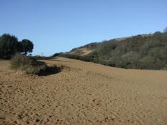
The initial part of the walk took me along the road leading from the church at Merthyr Mawr to the remains of Candleston Castle at the end of the road. This is quite an impressive ruin, not of a castle but of a fourteenth century fortified manor house. It had been occupied until the nineteenth century, and hence the ruins were much more intact than (for instance) the nearby Ogmore Castle, which I passed yesterday. I enjoyed walking around the castle and looking into the various rooms, following trails through the ruins that had obviously been made by people ignoring the danger signs, as I was. Many of the walls are covered in ivy and the ruins are in the middle of a wooded glade, giving the walls an ancient and untouched feeling. A lovely walk through the sand dunes of the Merhyr-mawr Warren followed this, which was lovely. There are lots of tracks through the warren and I tried to reach the beach near the mouth of the Ogmore River, which I managed to do quite successfully.
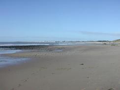
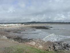
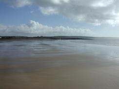
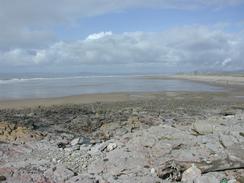
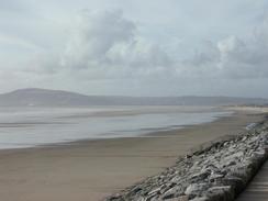
Some of the beaches today were absolutely superb, and in particular the Kenfig Sands were lovely, the distant steelworks not really spoiling the view. The sands are wide and expansive, and very firm underfoot that allowed me to walk along the beach quickly. When I had finished walking along Kenfig Sands I was faced with crossing the Afon Cynffig by fording. This large stream was spread out along a wide section of beach, and so I decided to ford the river rather than make the large inland diversion needed to get to the nearest bridge. The sand had been stripped off the beach and the stream was running over pebbles, and the going was easy although there were deep pools, and in one of these my left boot got filled up with water. Fortunately due to the warm weather this was nothing more than a slight annoyance, and perversely my left foot aches less after being soaked than it did before!
After I had forded the stream I was on Margam Sands and I was left with a choice that I found difficult to make. The long stretch of Margam Sands was absolutely beautiful, and even the nearby Margam steel works did not really spoil the view. The only public access to the beach is via a pubic footpath at the southern end of the beach that leads up to the roundabout at junction 38 of the M4, and so I would not walk along this lovely beach for long. I really wanted to, however, because the beach would be a much shorter walk than diverting inland, but at the northern end of the beach there are the Port Talbot docks that I would have to walk through. John Merrill walked through the port on his walk in 1978, but I did not want to risk finding access through the docks blocked and having to walk all the way back along the beach. Eventually I decided to walk the inland diversion, as this was the nearest official right of way to the sea, although it was far from a scenic or interesting walk.
I do not know if there is an unwritten rule in South Wales in springtime, but over the last few days I have not been able to find an open public toilet. In all the seaside towns with nice, clean seafronts and promenades, I have not seen an open toilet - they have been closed for the season. This is all well and good, but today I really needed to go to the toilet as I was walking through Porthcawl, but I could not find an open toilet, although there were plenty of shut ones. I therefore had no choice but to hold on (crossing my legs would do no good as I was walking), and for my troubles I got aching kidneys.
The weather forecast for tomorrow is for gales and lots of rain, so my plan to reach a point to the west of Mumbles Head may well need to be changed. The walk through Swansea to Mumbles should be flat and fairly easy going along roads and cycle paths, so at least I will not be slipping up and down hills as I did the other day.
Directions
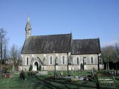
This walk starts off at Merhyr Mawr Church, which is to the southwest of Bridgend. Leave the church and turn right to head westwards along a road for a kilometre until it ends at a car park beside the ruins of Candleston Castle. Leave the car park and head southwestwards through the sand dunes of the Merhyr-mawr Warren until the Traeth yr Afon beach is reached.
At the beach turn right and head northwestwards along the beach and follow it as it slowly turns to head westwards until a car park is reached on the eastern side of Porthcawl. At the car park join a road and turn left to follow it southwestwards to Newton Point. Walk around the point and follow the path around Trecco Bay to Rhych Point, and then onwards past Sandy Bay to the harbour at Porthcawl Point.
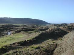
Leave the harbour and walk southwestwards along the promenade beside the road to Hutchwns Point. At the point leave the road and follow a path around the point and then northwestwards across Lock's Common. When a car park at Rest Bay is reached continue on northwestwards along the low cliffs, passing a golf course before reaching Sker Point.
Pass Sker Point and find a safe way down onto the southern end of the Kenfig Sands. Once on the Kenfig Sands head in a northerly direction along the beach for a couple of miles until the Afon Cynfig River is reached. Carefully ford the river; if it looks too fierce then you will have to walk eastwards along the southern bank of the river until you reach the B4283, and make the way to Port Talbot from there
On the other side of the river head along the beach for about a mile until just after a rock sea bank starts on the right. From here a footpath leads northeastwards along a rough track for a mile until it reaches the large Margam railway sidings. Carefully follow the path across the sidings and the main line beyond them, from where a surfaced road leads on and curves past a BOC factory before ending at Junction 38 of the M4.
From here the rest of the walk follows the National Cycle Network 4 route, which heads initially along the A48 before diverting along local roads inland. The path is marked on the OS 1 to 50,000 maps, and so it is very easy to follow and I will not describe the route in detail here. At Talbot Parkway railway station the cycle path crosses over to the southern side of the railway before heading southwestwards towards the seafront in Port Talbot.
At the seafront the path follows the seafront for a couple of miles before turning to the right and heading northeastwards past a large chemical works. This walk ends at an industrial estate on the left immediately before the A4241 road crosses over the M4.
Distances
| From | To | Distance (m) | Ascent (ft) | Descent (ft) |
|---|---|---|---|---|
| Merhyr Mawr | Porthcawl | 5.2 | 381 | 387 |
| Porthcawl | Baglan, Port Talbot | 16.1 | 873 | 879 |
This makes a total distance of 21.3 miles, with 1254 feet of ascent and 1266 feet of descent.
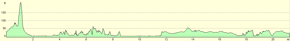
For more information on profiles, ascents and descents, see this page
Accommodation
We parked Mervan in the car park of the Beefeater pub in the village of Baglan, to the north of Port Talbot. They kindly let us park in their large car park, and the only problem was the noise of the traffic on the adjacent roads and the nearby M4.
Disclaimer
Please note that I take no responsibility for anything that may happen when following these directions. If you intend to follow this route, then please use the relevant maps and check the route out before you go out. As always when walking, use common sense and you should be fine.
If you find any information on any of these routes that is inaccurate, or you wish to add anything, then please email me.
All images on this site are © of the author. Any reproduction, retransmissions, or republication of all or part of any document found on this site is expressly prohibited, unless the author has explicitly granted its prior written consent to so reproduce, retransmit, or republish the material. All other rights reserved.
Although this site includes links providing convenient direct access to other Internet sites, I do not endorse, approve, certify or make warranties or representations as to the accuracy of the information on these sites.
And finally, enjoy your walking!
This walk was mentioned in the following routes:
| My walk around the coastline of Britain |
Nearby walks
| # | Title | Walk length (miles) |
|---|---|---|
| 374 | Summerhouse Point to Merthyr Mawr | 14.5 |
|
|

|