Walk #399: Harlech to Porthmadog
 |
 |
|
General Data
| Date Walked | 30/03/2003 |
| County | Gwynedd |
| Start Location | Harlech |
| End Location | Porthmadog |
| Start time | 10.36 |
| End time | 16.37 |
| Distance | 15.2 miles |
| Description | This was a long walk, and one that was quite satisfying, particularly with the views over Snowdonia available on this sunny day. |
| Pack | Today I carried my 30-litre Karrimor HotRock rucksack, which was filled with my packed lunch, waterproof leggings, water bottle and a couple of spare shirts, together with the usual assortment of odds and ends. |
| Condition | Over the last few days I have slowly been developing a few little aches and strains, which all seemed to start hurting at the same time today. The worst is my right wrist, which is aching after I strained it in a stupid way jumping down from a stile yesterday (my hand remained where it was as my body fell). My left knee is also hurting on descents, but fortunately I did not have too many of these today. I am also having little aches from both of my ankles, which fortunately are not bothering me too much. |
| Weather | Today was mostly sunny, but a big cloud layer came over for a couple of hours. There was some quite strong winds today, and these chilled me when I was exposed to them. This was not too bad, however, as the temperature was quite high even when the sun was hidden. Indeed, March has been an extremely warm month, and in some places it has been the warmest March on record. |
| OS map | Landranger number 124 (Dolgellau & Porthmadog) |
 |
 |
|
 |
 |
|
Map of the walk
Maps courtesy of Google Maps. Route for indicative purposes only, and may have been plotted after the walk. Please let me have comments on what you think of this new format. For a detailed table of timings for this walk, please see the table file.
 |
Notes
I had a very late start today, and unfortunately I ever really recovered from this. There are several reasons for this; the fact that the clocks went forward an hour, giving me an hour less in bed; the fact that my parents were staying at the campsite and the fact that I spent a few hours doing some work. Whilst this was all very nice (and the fact that it will not be getting dark until eight in the evening should be very handy), I still do not like setting off this late, as I always feel as though I am late in some way, even if there are plenty of hours left in the day.
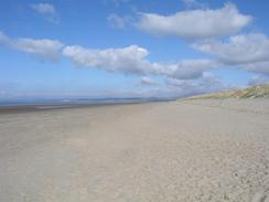
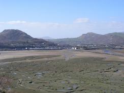
The first part of the route that I did was different - and longer - than the one that I had been planning to do. My plan had been to simply walk along the A496 north from Harlech, but my views over the beach to the west yesterday had been too tempting, and I chose to walk along this instead. The problem is that there is no access eastwards from the northern end of the beach, and therefore I had to trespass across marshland and fields to make my way to the nearest right of way, the footpath at the farm at Glan-y-mor. I am in two minds about whether the lovely walk along the beach was worth the hassle of getting back to the path, but what is done is done. If I had not done this walk then I may well have walked further to Criccieth as I had intended, but I am not too upset about this as my schedule stated that I would get to Porthmadog tonight anyway.
I have always loved Portmeirion, the Italianate village to the east of Porthmadog designed by the architect Clough William-Ellis. I have never visited the village, but have always enjoyed seeing it on its many appearances on television. The village was started in 1926 and completed in 1976, and is now used as a hotel. It is most famous for its use in the 1960's television series 'The Prisoner', filmed in 1966 to 1967. I was quite keen to go in and have a look around it for myself, but I baulked at paying the five pound fifty pence entry fee for what would have been a very quick look around - I could only have spent an hour there at most. I shall have to come back and visit here again in the future.
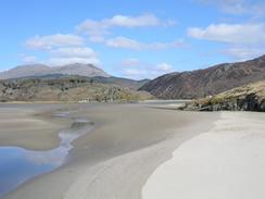
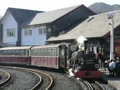
From Portmeirion I got lost whilst walking towards Boston Lodge. The way markers were very poor, and this led to me walking far to low down on the hillside, and whilst doing this I injured my left knee slightly. I eventually made my way down to Boston Lodge, and I was then faced with walking over the Cob, something I was very much looking forward to. The Cob is an embankment nearly one and a half kilometres long, built by MP William Alexander Maddocks in the early nineteenth century. The Cob has allowed over 10,000 acres of land to be reclaimed, and it also carries the Ffestiniog railway eastwards away from Porthmadog. As I crossed the Cob I got a great view over toward the distinctive peak of Snowdon, and this has made me even more determined to climb it a little later in this walk.
This evening we went for a drink in the Ship Inn in the town, where hey had some good live music playing. They kindly allowed us to do a collection, and it was quite late by the time that I dragged myself back to Mervan, although Sam stayed a little longer - the smoky atmosphere really got to me, and I really hd to leave as my eyes started watering. Despite this though it was a good evening, and the people in the pub were all very nice.
Tomorrow I should be able to get to Pwllheli fairly easily, and this marks the start of my walk around the Lleyn Peninsular. Several people in the pub last night told me how beautiful the peninsular is, so it should be a very good walk.
Directions
This walk starts off on the road outside Harlech Station. From the station take a road that heads off to the west, leading towards the beach. When the road ends at a car park continue straight on along a good path through the dunes to the beach, and then turn right to walk northwards beside the dunes. After a couple of miles the beach and dunes slowly starts curving to the right before settling on an easterly course to the south of the Afon Glasyn, eventually reaching Harlech Point.
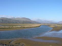
Here the route becomes more complex; the route to Ynys is blocked by flood channels, so from Harlech Point carefully head southeastwards across the marshes. These were mostly dry and firm when I passed, but after heavy rain it may be a different matter and it involved diverting occasionally to get around various drainage channels. Aim for the northernmost of two tracks that lead eastwards to the farm at Glan-y-mor. The walk from Harlech Point is not a right of way, so be very careful about this section of walk.
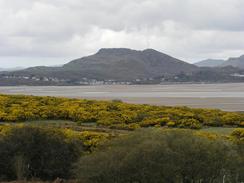
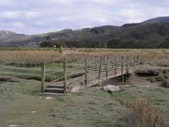
At Glan-y-mor join a footpath that heads northeastwards around the flank of a hill before it curves to head in a more easterly direction in a valley between two hills. When the footpath ends at a house turn right and follow the track from the house southwards, and at another farm this track becomes a public road that continues before ending at the A496 road to the south of Ynys. Turn left to head northeastwards along the A496 into Ynys, and when the road curves sharply to the right to cross a stream continue straight on down another road for about a hundred yards. When a flood bank becomes apparent to the right climb up onto the top of the bank and follow a footpath along it eastwards until a rickety bridge becomes apparent on the left.
Cross this bridge and on the other side join a flood bank and turn left to walk along a footpath at the top of the bank. This bank curves around, but heads in a more northeasterly direction for a couple of miles until it crosses a railway line and ends at a road. Turn left down this road and follow it past Llandecwyn Station and on towards the toll bridge over the estuary. Carefully cross this bridge, as it is very narrow, and on the other side of the bridge follow the road northwestwards past Penrhyndeudraeth Station until it ends at a junction with the A487 road. Turn left along the A487 and follow it westwards for a little over a kilometre, passing Minffordd Station, and then take the first road to the left (which is signposted for Portmeirion). Immediately after this junction take a road off to the right, and head for the car park for Portmeirion.
In the car park beside the entrance into Portmeirion take a footpath that heads from the corner of the car park. This footpath follows the boundary fence to the village for a short distance before heading northwards. This footpath is very poorly waymarked, and I managed to lose it easily whilst walking through the woodland. Try to make your way towards a track that leads northwards near the top of the hill before descending down to meet the A487 road at Boston Lodge. Turn left along the A487 for a short distance until you reach the Cob. Here you can walk along the Cob using the cycle track, but a much better route is to climb up and walk along the top of the Cob beside the narrow-gauge railway line. The footpath ends at the Ffestiniog railway line in Porthmadog, where this walk ends.
Distances
| From | To | Distance (m) | Ascent (ft) | Descent (ft) |
|---|---|---|---|---|
| Harlech | Llandecwyn Station | 10.5 | 364 | 377 |
| Llandecwyn Station | Porthmadog | 4.7 | 433 | 440 |
This makes a total distance of 15.2 miles, with 797 feet of ascent and 817 feet of descent.
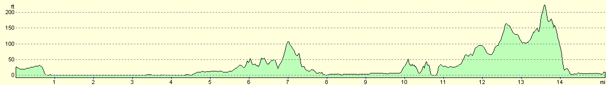
For more information on profiles, ascents and descents, see this page
Accommodation
We spent the night in a car park in the centre of Porthmadog, which was handy for some local pubs and other facilities. As usual this car park had sign prohibiting overnight sleeping, and as usual we ignored these.
Disclaimer
Please note that I take no responsibility for anything that may happen when following these directions. If you intend to follow this route, then please use the relevant maps and check the route out before you go out. As always when walking, use common sense and you should be fine.
If you find any information on any of these routes that is inaccurate, or you wish to add anything, then please email me.
All images on this site are © of the author. Any reproduction, retransmissions, or republication of all or part of any document found on this site is expressly prohibited, unless the author has explicitly granted its prior written consent to so reproduce, retransmit, or republish the material. All other rights reserved.
Although this site includes links providing convenient direct access to other Internet sites, I do not endorse, approve, certify or make warranties or representations as to the accuracy of the information on these sites.
And finally, enjoy your walking!
This walk was mentioned in the following routes:
| My walk around the coastline of Britain |
Nearby walks
| # | Title | Walk length (miles) |
|---|---|---|
| 398 | Fairbourne to Harlech | 17.8 |
|
|

|