Walk #416: Point of Ayr to Shotton
 |
 |
|
General Data
| Date Walked | 17/04/2003 |
| County | Clwyd |
| Start Location | Point of Ayr |
| End Location | Shotton |
| Start time | 09.10 |
| End time | 17.11 |
| Distance | 17.9 miles |
| Description | This was a fairly boring walk involving a great deal of road walking to get to my final position. |
| Pack | Today I carried my 30-litre Karrimor HotRock rucksack, which was filled with my packed lunch, waterproof leggings, water bottle and a couple of spare shirts, together with the usual assortment of odds and ends. |
| Condition | I feel absolutely fine after this walk, aside from a little ache in my right eye. My feet were well strapped up and gave me no problems at all, and I could easily have walked further if I had wanted to. |
| Weather | The weather today was quite like yesterday; sunny and very hot, with a nice, cooling breeze. I do not feel like it was quite as hot, as I found it to be less close. |
| OS map | Landranger number 117 (Chester & Wrexham, Ellesmere Port) |
 |
 |
|
 |
Map of the walk
Maps courtesy of Google Maps. Route for indicative purposes only, and may have been plotted after the walk. Please let me have comments on what you think of this new format. For a detailed table of timings for this walk, please see the table file.
Notes
Today was very much a day of chatting to people, and indeed meting people was by far the most memorable part of the day. The walk was not very scenic and in places just a long road trudge (although I could fortunately break these road sections up by walking along some convenient sections of flood bank). It was hardly a classic walk, and one that I have no real impulse to repeat in the future.
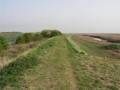
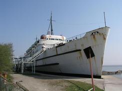
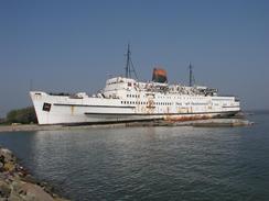
As I left the Point of Ayr I met a couple of council workmen who told me that there was going to be a ten metre tide today, which apparently is quite high. I did not really take any notice of this, as I was not expecting this to bother me at all, as my route did not go along any foreshores or beaches. As I walked along the flood bank southeastwards towards Llannerch-y-mor I could see a large ship in the distance. As I got closer it appeared to be right in the middle of the flood bank; an incongruous sight. When I finally reached the ship I could see that it was berthed right beside the flood bank where it made a diversion to head inland along a drainage channel to the A548 road. The ship is called the Duke of Lancaster, and I later found out that it had been beached there years ago and had been used as a floating disco. The ship looked very uncared for and was rusting badly; I doubt that the public has used it for years. As the footpath diverted inland I could see that the footpath on the other side of the drainage channel was starting to flood with seawater fro the high tide. This was particularly bad where the path dived under the railway line. It only took me a few minutes to reach the A548 and go around the other side, but by then the flooded area was much bigger. I managed to get around this area without getting my feet wet but walking along the side of the flood bank; a precarious walk due to the steep slope and brambles that were growing on the bank.
Over the last couple of weeks we have been aware that the rear offside tyre of Mervan had slowly been deflating. Every five or six days we were having to pump it up, and after this had been done three or four times we decided to get it looked at. Because the tyre was deflating slowly I expected a dodgy valve; when Sam took it to a tyre repair shop in Flint it turned out to be a screw in the tyre! This could have been very dangerous, as if it had moved we could have had a sudden puncture instead of a slow one, but fortunately that did not happen. The people at the tyre shop were nice enough to do the work for free, which was very kind of them, and after this Sam set off to pick up the post that my dad has sent to us via the poste restante service.
I had a little incident as I was walking along the A548 road in Mostyn. There is a section of road where the pavement gets quite narrow, and as I was walking eastwards into the morning sun I was squinting slightly. Due to this I did not see a low-flying branch that hit me slap-bank in the middle of the face, and a twig from the branch went into my right eye. This stunned me slightly, and I kept that eye closed as I put my right hand up to it. When I withdrew it, I could see blood on my palm. After a couple of minutes I could open my right eye and I could see okay, so I could only assume that the twig had missed the eyeball and hit the skin right next to the eye. It has been aching all day, and this evening it started to ache even more. I feel like writing to the local council and telling them that people over six feet tall walk along pavements, and they should be cleared to allow us to do so without risking life, limbs or eyes!
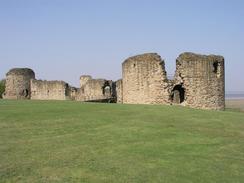
My original schedule had been for this walk to end at Flint Castle, but because I walked further than I had planned yesterday I had to extend this walk. I met Sam at Flint Castle anyway, so that I could have a quick rest and we could plan where I was going to finish. The castle is ruinous but quite nice, and Edward I built it in the thirteenth century. It is fairly unusual in that the keep is situated on a separate islet, so that ships could resupply it even if the rest of the castle was captured. Since then there has been much silting up of the river, and the castle is a short distance from the water's edge. As I approached the castle I went for a quick walk around it, and met a man who I assume was in a rather drunken state. He asked me if I was doing the Coastwalk, and when I replied yes he said that he had read the banner on the window of the van. He asked me details about he specification of the van, and then amazingly said that he had been considering nicking it until he had read the banner and see that it was to do with a charity! I did not know whether to take this rather outlandish claim seriously, but I bade him goodbye fairly swiftly and walked down to where Sam was waiting in Mervan.
As I was passing through Connah's Quay and Shotton I nipped into three or four pubs on the way and did impromptu collections. The pubs were not very busy and there were not many people in them, but I had nice chats to people and collected a little bit more money for the charity. In one pub, The Clwyd, I was given a free pint, which was very kind of the owner. As I drunk I chatted to a few of the people in the pub, and although I was offered another I had to leave as Sam was waiting for me. I met Sam a short distance further on down the road in the car park of a B&Q, and we then drove to the campsite. We had been aware that getting a campsite over the bank holiday weekend could be a problem, and so we decided to get one tonight (this way we can last out until Tuesday night, in other words five nights). There was only one campsite in the Flint area and that was full, but the owner was kind enough to let us stay anyway. This was indeed very kind of them, and Sam spent ages taking to the owners of the site whilst I did some work on the website.
Tomorrow I am aiming to walk up the northern coast of the River Dee towards West Kirby. This means that after a short walk I shall reach the little village of Shotwick and cross over the Welsh / English border. I am unsure about how it will feel to have completed my first country; even if I was to fail in completing the rest of the walk, I feel that it will be an achievement to have done this. It should not take me much longer to complete England, as there is not very much of England on the west coast between the borders of Wales and Scotland; I expect to reach the Scottish border in about a months time.
Directions
This walk starts off at the car park by the Smugglers Inn at the Point of Ayr. Leave the car park and turn right down the road, passing the pub and reaching an embankment. Turn right to head south along a footpath down the embankment. After a kilometre my map shows the path turning to the right, heading westwards to avoid a factory building; however this building has been demolished and I could continue southwards to join a road that dived under a railway line under a bridge. On the southern side of the bridge turn left by a building to join a footpath that heads southeastwards along the top of a flood bank. This footpath crosses the A548 road before ending at a road in the village of Ffynnongroyw.
Turn left to head southeastwards through the village until it meets the dual carriageway A548 once more. Fortunately there is pavement on the far side of the road, and this makes the walk along the road easier. The road passes Mostyn Quay and passes a pub on the right before a footpath leads off to the left. This footpath crosses a bridge over a railway line before meeting a track by the river. Follow the path southeastwards alongside the river until a large white ship is reached alongside an inlet.
The footpath then turns to the right to head under the railway line and reach the A548 road. Turn left along the A548 to cross the inlet and then turn left along another footpath that heads under the railway line and reaches the riverfront once more. Follow the path southeastwards for a couple of miles until it reaches Greenfield Dock.
Cross the dock and continue on along the riverfront along a footpath past Greenfield. Near a little inlet a footpath heads off to the right, crossing a railway line and emerging onto the A548. Turn left along the A548 (unfortunately there is no pavement) and follow it as passes the junction with the A5026 until a road leads off to the right to head into Bagillt. Follow the road as it heads through the village and emerges onto the A548 once more.
Continue on southeastwards into the village of Flint; if you want to visit the castle then turn left by the station, otherwise continue on along the A548. Pass the paper mill in Oakenholt before joining the B5129 road, and follow this road as it heads through Connah's Quay and Shotton. This walk ends a few hundred yards past the station, where there is a B&Q superstore.
Distances
| From | To | Distance (m) | Ascent (ft) | Descent (ft) |
|---|---|---|---|---|
| Point of Ayr | Bagillt | 10.6 | 344 | 312 |
| Bagillt | Shotton | 7.3 | 230 | 243 |
This makes a total distance of 17.9 miles, with 574 feet of ascent and 555 feet of descent.
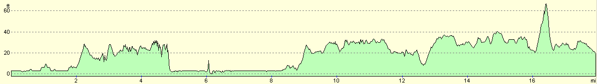
For more information on profiles, ascents and descents, see this page
Accommodation
We stayed at the lovely site at Ty Llwyd, Halkyn, Holywell CH8 8BY. They can be contacted on (01352) 780748. This is a lovely little site that cost us only seven pounds for the night. They were kind enough to let us stay despite that fact that they were fully booked; an act of kindness that we shall not forget.
Disclaimer
Please note that I take no responsibility for anything that may happen when following these directions. If you intend to follow this route, then please use the relevant maps and check the route out before you go out. As always when walking, use common sense and you should be fine.
If you find any information on any of these routes that is inaccurate, or you wish to add anything, then please email me.
All images on this site are © of the author. Any reproduction, retransmissions, or republication of all or part of any document found on this site is expressly prohibited, unless the author has explicitly granted its prior written consent to so reproduce, retransmit, or republish the material. All other rights reserved.
Although this site includes links providing convenient direct access to other Internet sites, I do not endorse, approve, certify or make warranties or representations as to the accuracy of the information on these sites.
And finally, enjoy your walking!
This walk was mentioned in the following routes:
| My walk around the coastline of Britain |
Nearby walks
| # | Title | Walk length (miles) |
|---|---|---|
| 415 | Rhos-on-Sea to Point of Ayr | 19.9 |
| 417 | Shotton to Hoylake | 19.0 |
| 769 | Bodfari to Prestatyn | 12.7 |
|
|

|