Walk #504: Glenelg to Morvich
 |
 |
|
General Data
| Date Walked | 20/07/2003 |
| County | Highlands |
| Start Location | Glenelg |
| End Location | Morvich |
| Start time | 09.35 |
| End time | 16.35 |
| Distance | 18.0 miles |
| Description | This was a mixed walk, with road and path walking and some superb view over the sea and a couple of lochs. |
| Pack | Today I carried my 30-litre Karrimor HotRock rucksack, which was filled with my packed lunch, waterproof leggings, water bottle and a couple of spare shirts, together with the usual assortment of odds and ends. |
| Condition | Aside from the underside of my feet aching I have no significant problems after this walk, and if I had changed into my trainers I could have easily walked further. |
| Weather | Today was literally a day of sunshine and showers, with some light showers interspersed with brighter spells. The showers were never too hard, and I did not bother putting my coat on for them as it was a warm day. |
| OS map | Landranger number 33 (Loch Alsh, Glen Shiel & Loch Hourn) |
 |
 |
|
 |
 |
|
Map of the walk
Maps courtesy of Google Maps. Route for indicative purposes only, and may have been plotted after the walk. Please let me have comments on what you think of this new format. For a detailed table of timings for this walk, please see the table file.
 |
 |
|
Notes
For the second day running it was raining as I woke up, but fortunately by the time I had properly awoke and opened the blinds it had stopped, with a few patches of blue sky visible. It took me some time to get myself ready for the walk, but eventually I was ready to head off. I had only gone a few yards when a car stopped beside me and the couple inside gave me a donation for the charity - they had overheard us talking in the pub last night, and we chatted for a few minutes about the walk. Once I had restarted I passed the rather dominant remains of Bernera Barracks, built in 1722 to help control the Highland Clans, and it was eventually abandoned in 1790. The ruins were fenced off so I could not look around them, but even from a slight distance I could see how the barracks would have dominated the area.
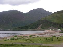
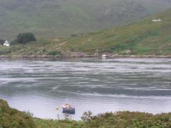
I was looking forward to seeing the ferry that led across the Kyle Rhea to Kylerhe on Skye, as Graham had said that it was the best ferry in Britain. I knew that the ferry had an unusual turntable arrangement (the cars drive on a an angle and then the table gets turned onto the boat), but unfortunately when I got to the jetty it had just started out across to Skye. I really did not want to have to wait fro it, so I decided to move on - I could easily come back to visit here some other time.
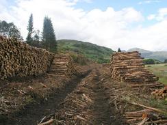
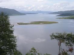
The initial walk through was along a lovely woodland path, and there were occasional good views over Kyle rhea and Loch Alsh. Eventually the path descended down onto the foreshore, and I chose to walk along the shingle beach rather than along the grassy path, as my trousers were getting soaked from the waist-high grass, made wet by a twenty-minute shower. At Ardintoul it all started to go pear-shaped. My Ordnance Survey map showed the path climbing uphill along the Allt na alach and then skirt the hillside. When I approached a house at the bottom of the river a woman came out and told me that the path had been diverted due to the forestry clearance operations. She gave me some alternative directions, but I could see no footpath diversion signs and something in her manner made me not fully trust her, but I followed her directions and soon got lost. I decided the best thing would be to try and find the path as marked on the map, so I ended up climbing up a steep slope through dense forest. More than once I though that I had found a track only to find it end in some impenetrable trees; this was thoroughly depressing and quickly got me down. I sat down fro a couple of minutes to think through my options; I could either continue trying to find a path or go back down and work my way around via the road; I was loathe to do the latter, and so I worked my way higher around a little crag to some flatter ground. Eventually I found an old and overgrown path contouring the hillside, and I followed this. The going was easier, and I eventually found a far better path through the tress, and on this were some signs in the other direction stating that the path was diverted straight down the hill. The lady had been correct; and if I had believed her more I would have saved myself much time floundering around steep wooded hillsides!
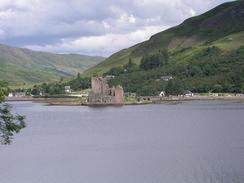
Once I had found the proper path I managed to get myself going quickly again as it descended slowly though a cleared area of woodland and past the remains of Letterfearn broch; the second-best preserved example that I had seen on the trip. These structures are of quite an amazing scale considering that they are over 2,000 years old, and it is a shame than none exist intact today. Once I reached the end of the public road I sat down on a bench outside a public house at Totaig and ate my lunch as I looked over the loch towards Eilean Donan Castle. It was the first time that I have ever seen this castle in reality, and I had first seen it in a film called Highlander years before. Seeing the castle was one of the things that I had most been looking forward to on the trip, and seeing it across the water and examining it with my ocular was superb.
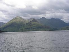
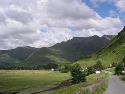
The majority of the rest of the walk was a long road plod down the western shore of Loch Duich. The views across the loch were beautiful when the sun was shining, and the Five Sisters of Kintail - five Munroes close together in a mini mountain range - were calling out to be climbed. I have never really been a keen Munroist; I have climbed a few, but only when there has been some other objective in mind. The mountains that I have seen over the last few days have really inspired me, however, and the idea of climbing some of them is becoming increasingly appealing. I do not think that I will climb them all; I live too far away to make this practical, but I think that I may choose a select few and climb those.
By the time that I reached the campsite the underside of my feet were aching a great deal, as water had got into my boots earlier in the day. When I took my boots and socks off my feet looked like boiled prunes, all wrinkled and pasty in colour. Once I had dried them off they soon recovered, and they gave me no trouble this evening. The campsite that we are staying at is quite nice, and a hot shower is just what I needed to revitalise myself after the rigours of the last few days walking. The campsite is fairly busy, with many caravans, motor homes and tents on it, and I feel sorry for the people camping as it has been raining fairly continuously all evening - it is on nights like this that I am glad we have Mervan!
Tomorrow is going to be a long road plod along the A87(T) towards the Kyle of Lochalsh. Normally main roads like this would be very boring, but this one promises to be lovely as the views over the lochs, mountains and castles ought to be fantastic if the weather is nice.
Directions
This walk starts off at the Glenelg Inn in Glenelg. Leave the Inn and turn left along the road for a short distance until it turns to the right near a phone box on the left. At this bend continue straight on along a track that passes the ruins of Bernera Barracks, where the track ends and a path continues on across some marshland. The path eventually ends at a public road near Galltair, and then turn left and follow the road northwestwards for over a mile until the road ends at a little ferry terminal.
Just before the ferry is reached there is a car park on the right. Enter the car park and then take a track that heads out of its end. The track enters some woodland and winds around before reaching a large electricity pylon. Here the track becomes a path and is very clear as it continues through the woodland until near Garbhan Cosach, after which the path drops down and follows the foreshore eastwards along Camas nan Gall. The path heads towards Ardintoul Point before heading inland and joining a track that passes Ardintoul Farm. From here I cannot give accurate directions for the next few miles; the path that is marked on my 1997 Ordnance Survey map does not exist and there is a new diversion, but as this was signed from the east I could not find it. I believe that the new path follows the foreshore east from Ardintoul and crosses the Allt na Dalach before eventually climbing steeply uphill to join the old path in the forest on the hillside. Follow this path as it slowly descends past Letterfearn Broch and finally ends by a white cottage at Totaig.
From Totaig follow the road as it heads southeastwards along the southern shore of Loch Duich for about six miles until it crosses the River Shiel and ends at the A78(T). Turn left up the A78(T) and follow it northeastwards for about a mile, and then before the road joins the causeway turn right down another road that passes through Carn-gorm. Just before Croe Brrige is reached a road leads off to the right; the campsite where this walk ends is about a hundred yards down this road on the left.
Distances
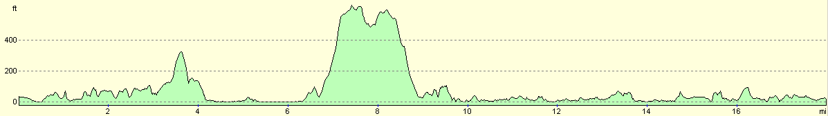
| From | To | Distance (m) | Ascent (ft) | Descent (ft) |
|---|---|---|---|---|
| Glenelg Inn | Totaig | 9.4 | 1785 | 1798 |
| Totaig | Shiel Bridge | 6.1 | 850 | 873 |
| Shiel Bridge | Morvich campsite | 2.5 | 367 | 351 |
This makes a total distance of 18.0 miles, with 3002 feet of ascent and 3022 feet of descent.
For more information on profiles, ascents and descents, see this page
Accommodation
We spent the night at the Morvich Caravan Club Site, Inverinate, Kyle IV40 8HQ, and they can be contacted on (01599) 511354. This site cost us fourteen pounds fifty pence for the night, and the warden was a little rude. The site was clean and tidy, however, and the facilities were nice.
Disclaimer
Please note that I take no responsibility for anything that may happen when following these directions. If you intend to follow this route, then please use the relevant maps and check the route out before you go out. As always when walking, use common sense and you should be fine.
If you find any information on any of these routes that is inaccurate, or you wish to add anything, then please email me.
All images on this site are © of the author. Any reproduction, retransmissions, or republication of all or part of any document found on this site is expressly prohibited, unless the author has explicitly granted its prior written consent to so reproduce, retransmit, or republish the material. All other rights reserved.
Although this site includes links providing convenient direct access to other Internet sites, I do not endorse, approve, certify or make warranties or representations as to the accuracy of the information on these sites.
And finally, enjoy your walking!
This walk was mentioned in the following routes:
| My walk around the coastline of Britain |
Nearby walks
| # | Title | Walk length (miles) |
|---|---|---|
| 503 | Kinloch Hourn to Glenelg | 19.9 |
| 505 | Morvich to Kyle of Lochalsh | 15.6 |
| 506 | Kyle of Lochalsh to Strathcarron | 19.7 |
|
|

|