Walk #510: Ardheslaig to Alligin Shuas
 |
 |
|
General Data
| Date Walked | 26/07/2003 |
| County | Highlands |
| Start Location | Ardheslaig |
| End Location | Alligin Shuas |
| Start time | 09.58 |
| End time | 16.30 |
| Distance | 17.4 miles |
| Description | Although this was a long walk along roads with only a short stretch of path, it was highly enjoyable due to the marvellous and stunning scenery. |
| Pack | Today I carried my 30-litre Karrimor HotRock rucksack, which was filled with my packed lunch, waterproof leggings, water bottle and a couple of spare shirts, together with the usual assortment of odds and ends. |
| Condition | I feel absolutely fine after this walk, and have suffered no significant problems. I could easily have walked further if I had to, but that was not necessary. |
| Weather | Today was a day of sunshine and cloud; there was a great deal of cloud, but also some significant sunny periods. This made for quite a nice day, and there was only a couple of minutes of drizzle in the mid afternoon. It was quite breezy in places, however, and this helped keep me cool when I was exposed to it. |
| OS map | Landranger number 24 (Raasay & Applecross, Loch Torridon & Plockton) |
 |
 |
|
 |
 |
|
Map of the walk
Maps courtesy of Google Maps. Route for indicative purposes only, and may have been plotted after the walk. Please let me have comments on what you think of this new format. For a detailed table of timings for this walk, please see the table file.
 |
 |
|
Notes
The five-mile drive this morning from Shieldaig back to Ardheslaig, where I ended yesterday's walk, was interesting - the road winds around and climbs and falls, and hardly lends itself to a fast drive, particularly in a top-heavy motorhome! When we reached the lay-by where I finished yesterday's walk I was a little whiter, and I was glad to get out and start the walk.
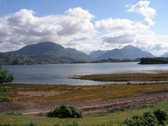
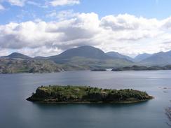
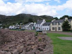
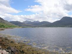
From the start the views were superb, and I took many photographs over Loch Shieldaig as I walked down the winding road. All the time the Torridon Mountains were visible over the loch, and I had to stop occasionally to let the view soak in. The road eventually descended to meet the A896 road, and I walked along it for a short distance before diverting to walk through the beautiful little village of Shieldaig. The village is all very neat, from the waterfront area to the houses behind, and I enjoyed the little stroll through it. I met Sam at the little caravan park above the village, where we had spent the previous night. Sam was talking to a couple on another motorhome, and we chatted for a few minutes before I set off on the walk once again.
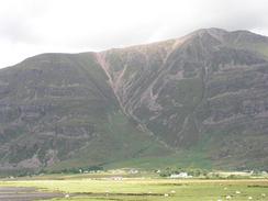
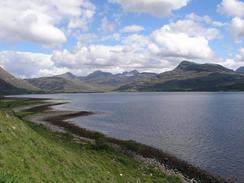
The walk to the village of Torridon at the head of Loch Torridon was typified by superb views of the surrounding mountains, and in one place there was a viewpoint beside the road that allowed expansive views over the loch and mountains. Eventually I reached Sam, who had parked Mervan by a visitors centre by a road junction in Torridon, and I climbed in to at my lunch. Sam was busy reorganising all the cupboards in Mervan; as the walk has gone on we have collected many items - books, magazines, pebbles and a thousand and one over nick-nacks, all small individual memories of the trip. These have slowly filled up all the cupboards until it got to the stage that one of mine flew open whilst Sam was driving, smashing the hair clippers. For this reason Sam was going through everything, working out what we could put in the topbox and what could be thrown out. She had a pile of items for me to look through, and I did this and put about half for storage, which will make a big difference to our comfort in Mervan.
I had planned to end today's walk at Diabaig, which would allow me to reach Gairloch tomorrow. Unfortunately the four-mile stretch of road from Alligin Shuas to Diabaig is very steep and winding, and Sam did not want to drive Mervan along it if it could be avoided. I was fairly happy to end the walk at Alligin Shuas as I had done a reasonable distance for the day, and ending four miles early would not stop me doing the path northwestwards to Redpoint tomorrow, so we agreed to meet at the road junction in Alligin Shuas, which is only a scattering of houses.
Sam wanted to drive back to Torridon for the night, a four-mile drive along the road. The main reason was so that we could have showers, but I could really not see the point of doing the drive when she would have to drive me back here in the morning so that I could restart the walk. This decision turned out quite well, as the place that we parked Mervan for the night was fantastic - the views over Loch Torridon and the Torridon mountains were sublime, especially as the sun was shining for a long time this evening. The views were so expansive that I walked a few yards along the ground (which at this point consisted of simply a flat surface of rock) so that I could take some photos. My camera has a panorama function that I rarely use - I tried using it a couple of years ago with my previous Olympus camera in Shropshire with negligible results - I had not used a tripod and the wind was trying to blow me over, so the photographs did not line up well. I tried it again this evening, and although I still did not have a tripod I am more hopeful of getting a reasonable result. The views really do deserve good photos - it is one of the best places that we have spent a night on this trip.
I am extremely tempted to climb a Munro tomorrow - maybe Beinn Alligin, the start of which is just down the road, or perhaps Liathach, a little further to the east. I shall make a final decision in the morning when I see what the weather is doing before I make a decision. If there is any cloud I do not think that I will bother - doing a Munro will be a distraction from the coastal walk, and will therefore only be worth doing if the weather is ideal. It is extremely tempting, though.
Directions
This walk starts off at a lay-by immediately to the southeast of the junction with the road leading to Ardheslaig. Simply walk along the road southeastwards for a little over three and a half miles until the road ends at a junction with the A896 road. At the junction turn left to had northwards along the eastern bank of Loch Shieldiag for about a kilometre until a road junction is met on the left. Turn left and follow the road as it heads through the village before climbing uphill to the right and ending at a T-junction with the A896 once more.
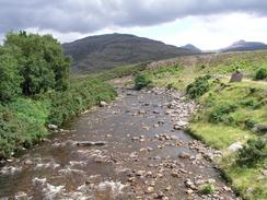
Turn left to head eastwards along the A896 road. It initially passes the Ob Mheallaidh before descending to go over the outfall of Loch Damph beforee climbing up to a viewpoint over the loch and then descending down to pass a pub and the Torridon Hotel. Immediately after this the road passes the head of the loch and through the village of Annat and crosses over the River Torridon. Half a kilometre after the bridge turn left down a minor road that heads northwestwards through the villages of Torridon and Fasag. Continue on along the northern bank of the loch for a little over a mile until the road climbs up sharply to the right, where a private driveway continues straight on along the shore of the loch. Take the driveway that forms a track that follows the shore until it curves to the right. As it does so turn left down another track that crosses the Abhainn Coire Mhic Nobuil on a bridge and curves around past some cottages, after which it curves to the left to head westwards towards a church. At the church the track becomes a distinct path that continues on before ending at the end of a road in Rechullin. Join the road and follow it westwards along the northern bank of the loch for over a mile past the jetty at Inverallign, after which the road climbs steeply up to the right before ending at a road junction in Alligin Shuas, where this walk ends.
Distances
| From | To | Distance (m) | Ascent (ft) | Descent (ft) |
|---|---|---|---|---|
| Ardheslaig | Shieldaig | 4.9 | 906 | 971 |
| Shieldaig | Torridon | 7.3 | 951 | 909 |
| Torridon | Alligin Shuas | 5.2 | 778 | 591 |
This makes a total distance of 17.4 miles, with 2635 feet of ascent and 2471 feet of descent.
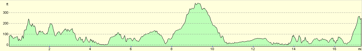
For more information on profiles, ascents and descents, see this page
Accommodation
A couple of hundred yards up the road from the road junction from Inveralligin there was a flat area of rock beside the road, where we parked for the night. There were no facilities nearby, but the views out of our window over the Torridon Hills were stupendous.
Disclaimer
Please note that I take no responsibility for anything that may happen when following these directions. If you intend to follow this route, then please use the relevant maps and check the route out before you go out. As always when walking, use common sense and you should be fine.
If you find any information on any of these routes that is inaccurate, or you wish to add anything, then please email me.
All images on this site are © of the author. Any reproduction, retransmissions, or republication of all or part of any document found on this site is expressly prohibited, unless the author has explicitly granted its prior written consent to so reproduce, retransmit, or republish the material. All other rights reserved.
Although this site includes links providing convenient direct access to other Internet sites, I do not endorse, approve, certify or make warranties or representations as to the accuracy of the information on these sites.
And finally, enjoy your walking!
This walk was mentioned in the following routes:
| My walk around the coastline of Britain |
Nearby walks
| # | Title | Walk length (miles) |
|---|---|---|
| 509 | Applecross to Ardheslaig | 20.2 |
|
|

|