Walk #587: A circular walk between Baslow and Grindleford
 |
 |
|
General Data
| Date Walked | 24/01/2004 |
| County | Derbyshire |
| Start Location | Baslow car park |
| End Location | Baslow car park |
| Start time | 08.43 |
| End time | 15.12 |
| Distance | 16.1 miles |
| Description | This was a beautiful walk, taking in the gritstone edges to the north of the village of Baslow. |
| Pack | Today I carried my 30-litre Karrimor HotRock rucksack, which was filled with my waterproof leggings, water bottle, trainers and a couple of spare shirts, together with the usual assortment of odds and ends. |
| Condition | I feel absolutely fine after this walk, and I could easily have walked further if I had needed to. I have no blisters, and my feet and legs are fine. |
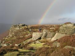
| Weather | The weather today was very mixed; for most of the time the skies were sunny, but there was a brisk and chilly wind that brought in occasional showers of drizzle and rain. This led to many rainbows being visible in the sky, which added dramatic effect to the gritstone edges. |
| OS map | Outdoor Leisure number 24 (The Peak District - White Peak Area) |
 |
 |
|
 |
 |
|
Map of the walk
Maps courtesy of Google Maps. Route for indicative purposes only, and may have been plotted after the walk. Please let me have comments on what you think of this new format. For a detailed table of timings for this walk, please see the table file.
Notes
The weather forecast for today looked quite promising, so I decided to make a visit to the eastern gritstone edges of the Peak District, specifically so that I could experiment with the new wide-angle lens that I bought this week for my camera. I had planned a 20-mile circular walk based on Baslow, but as I could not locate the map of the area to the north of Grindleford I was forced to limit myself to the area south of there. The drive through the Peak District to Baslow was nice, and I was pleased to see that the mornings were getting lighter earlier; the only annoyance being the two pound fifty pence charge for all-day parking in the car park - an absolute rip-off.
Roads led uphill out of Baslow, and these were soon followed by a track, churned muddy by boots and all-terrain motorbikes, that lead uphill onto the East Moors. On the way I passed Lady Wall Well, which is marked on the map but was singularly unimpressive on the ground - nothing more than a water-filled trough by a wall. The going got muddier until I reached an old quarry and the terrain flattened. Instead of turning left to walk northwards along Baslow Edge I walked eastwards for a short distance to Wellington's Monument, a simple cross on the southern edge of the moorland, with some fairly expansive views that were obscured by the sun, which was low in the sky at this time of the morning.
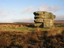
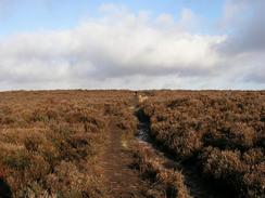
Another path took me to the Eagle Stone, a large chunk of stone sitting in the middle of otherwise featureless moorland. I walked around this strange feature and took some photos of it, before heading off along the broad track that heads northwards towards the road and car park at Curbar Gap. I then had a choice of routes; the most obvious one headed north along Curbar Edge, but I chose to climb up onto the higher ground of White Edge to the northeast. The path here was again muddy, and my trouser legs were by this time stained dark brown by the peaty water that was being thrown up by my feet.
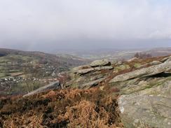
Once at the top of White Edge I was greeted by expansive views to the west; I could see right over Curbar edge and over towards Hope and Kinder Scout to the northwest. The wind was strong but not troublesome, and after passing the trig point on the edge I slowly descended past the Hurkling Stone (a stone sticking out from the edge of the escarpment), and headed across White Edge Moor. Once I reached the junction of the B6054 and A625 roads I was faced with a choice; I wanted to continue northwards towards Stanage Edge, but as I did not have the relevant OS map with me I was forced to head below another little escarpment towards Longshaw Lodge.
On the map there is marked 'Little John's Well' beside the escarpment, but I singularly failed to find anything that was of note; simply a little trickle of a stream running from below the path. Longshaw Lodge itself was much more impressive; a grand stone building that is now owned and run by the National Trust. A path took me past a pond, after which I headed downhill, crossing the B6521 road and reaching Grindleford Station. This was a fairly unnecessary diversion, but I wanted to nip into the famous cafe in the station building - a Mecca for walkers and climbers. I did not fancy a big meal, but I treated myself to a bacon and egg bap - and unusually I did not have one of the gigantic mugs of tea with it.
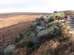
Half an hour later - and with the inner man well and truly satisfied - I set off back up the hill. I had decided to walk back along the lower escarpments of Froggatt and Curbar edges, which would make a nice, compact circular walk. These edges proved to be absolutely fantastic - great, sculpted rock formations hanging over some medium-sized cliffs. Unfortunately at some of the best views a rain shower came in, which prevented me from taking some nice photographs - however the storm was again accompanied by a couple of rainbows, which made up for the inconvenience somewhat. One downside to walking the edges was that the path resembled a pedestrian motorway, and the whole world seemed to be walking along it. I tried to ignore the people and just soaked up the scenery on the edges, as well as promising myself that I would have to come here again on a sunny summers day.
When I reached the road at Curbar Gap I decided to walk along Baslow Edge back to Wellington's Monument. Instead of following the broad track that I had walked along earlier, I decided to stick to a far smaller path that stuck closely to the edge. I was exceedingly glad about this, as the views were infinitely better than the track, only a few yards inland. The path skirted the edge and passed reasonably far away from the Eagle Stone; when the southern edge of the moor was reached I turned left to walk back towards the monument. Annoyingly again the sun was in the wrong position to get a good photograph of the monument - it was still too low in the sky.
As I walked along the track that leads from Wellington's Monument to the A621 road I was most surprised to see Highland Cattle in a field off to the left; I am a long way from the Highlands, and although I saw some a month or so ago on another walk in Derbyshire, I was not prepared to see so many in one field. I took some photographs for Sam (who loves Highland cows), and tried to attract some towards the wall so that I could take some better shots, but I failed miserably and they remained standing where they were. Apparently the grass that I was offering them was not tasty enough!
The track ended at a road, and a hundred yards after that reached a crossroads with the A621 road. Another road took me straight on uphill, and I then climbed over a fence and walked across some fairly desolate moorland, punctuated by the odd straggly tree, to the trig point on Birchen Edge. From here there was another wonderful walk along the edge towards Nelson's Monument, a simple pillar commemorating the famous sailor. Here I saw he first climbers of the day, doing various pitches up the rock face. Nearby were three prominent stones called the 'Three Ships', and with a little imagination I could see them as being three ships sailing in line. The rest of Birchen Edge was lovely, and when it ended a steep descent took me downhill to a track, which in turn led onto the B5060 road near the Robin Hood Inn.
Unfortunately to get back to the car in Baslow I had to walk along main roads, but the pavement that ran alongside the road made this bearable. Eventually I reached the car park and could get out of my boots, elated at having completed a superb walk. It is one that I shall definitely have to do again (maybe in a varied form) in the near future.
Directions
This walk starts off at the car park on the A619 road in the village of Baslow. Leave the car park and pass by the public toilets to reach the A619 road. Cross the road, and once on the other side head up Eaton Hill road. When the road curves sharply to the left turn right up Bar Road; initially the road is surfaced, but as it goes higher it becomes increasingly rough and muddier. The track curves sharply to the right and then the left, before settling on a north-northeasterly route uphill. As the gradient slackens it passes to the right of a disused quarry, and continues on along the southern edge of the moorland to a simple stone cross called Wellington's Monument. Once at the monument head back on yourself down the track for a few yards before taking a path that heads northwesterly across the moorland to the prominent Eagle Stone.
Once at the Eagle Stone join a wide track that heads northwards for a little under a kilometre to a road at Curbar Gap. Once the road is reached turn right and follow it past a car park; at the far end of the car park go through a stile and take a path that diverges away from the road to the left. This path heads northeastwards, descending slowly downhill to cross the Sandyford Brook and climbing uphill for a short distance. Near the top of the hill (and near a cairn) a path leads off to the left, following White Edge. Take this footpath (diverting off to see the trig point if you wish) for a couple of miles until a wall is reached just beyond the Hurkling Stone. Go through a stile and continue straight on along a path across the moorland that leads in a rough northerly direction towards a junction of the B6054 and A625 roads.
At the B6054 road turn left and walk northwestwards for a few yards to the road junction. At the junction continue straight on to the far side of the A625, where a footpath starts down a track. The track heads northwards below a little escarpment, before entering an area of woodland and descending down and around the northern edge of Longshaw Lodge. When the track reaches a T-junction with another track turn left for a few yards, before climbing over a stile to the right to join a footpath. This footpath is east to follow as it skirts in front of Longshaw Lodge. A little ditch starts on the left as it enters an area of woodland; fairly soon the path turns to the right to heads towards a lake. It skirts the side of the lake and a few yards further on take an indistinct path that leads off to the left.
The path heads south-southwestwards and eventually becomes more distinct as it turns to head southwards and joins the top edge of a wooded escarpment. After a few hundred yards a path dives off downhill to the right; the descent is steep but there are some handy steps that make the going far easier. The path ends at the B6521 road; cross the road and once on the other side turn left for a few yards and then turn sharply to the right down a surfaced footpath that leads down to Grindleford Station; the station cafe is a few yards downhill on the right, in the old station building. Once you have refreshed your body climb back up the surfaced path back to the B6521 road, and then turn right to walk southwards along the road for a short distance. Shortly after a right-hand bend a surfaced road leads off to the left, take a footpath that heads off to the left, heading uphill slightly to the east of southwards past Tumbling Hill and entering Hay Wood. A stream is crossed, after which the path climbs sharply to reach the A625 road.
Turn left and follow the road westwards for a few yards, before taking a footpath that heads off to the left, keeping to the higher edge of the moorland as it winds southwestwards immediately above Froggatt Edge. Keep to the high ground as the path curves to take a more southeasterly course, tunning above Curbar Edge before rejoining the path walked earlier on beside a road at the car park at Curbar Gap. Head south along the path above Baslow Edge, retracing the earlier part of the walk past the Eagle Stone to Wellington's Monument, but then instead of turning right continue on slightly north of eastwards. The path skirts the edge of the high ground for a little over a kilometre before reaching a road. Turn right along this road and follow it eastwards for a few yards until it reaches the A621 road; cross this and continue straight on along a road on the other side.
Follow this road as it heads uphill; it curves to the right to take a more southeasterly course. Near the 287-metre point on the map, climb over the wall and fence to enter the moorland to the south (note that this is not a right of way, and hence you may want too find a better route further down the hill). Head southwestwards across the moorland; the going is not hard although there is no path, and aim to reach the trig point on Birchen Edge. Once at the trig point, follow an obvious path southwards along the edge, passing Nelson's Monument and then the 'Three Ships' (three large rocks). Once at the southern edge of the escarpment turn right and take a very steep path down to the track that runs along the base of the escarpment; once on the track turn left and follow it out to the B6050 road. Once on the road turn right and follow it for a short distance past the Robin Hood Inn to a junction with the A619 road. Continue straight on at the junction to head downhill along the A619; after a mile a roundabout is reached with the A621 road. Here turn half-left to follow the A619 westwards into Baslow; the car park where this walk started is a few hundred yards further on from the roundabout on the left.
Distances
| From | To | Distance (m) | Ascent (ft) | Descent (ft) |
|---|---|---|---|---|
| Baslow car park | Grindleford Station | 7.5 | 1250 | 997 |
| Grindleford Station | Baslow car park | 8.6 | 1030 | 1283 |
This makes a total distance of 16.1 miles, with 2280 feet of ascent and 2280 feet of descent.
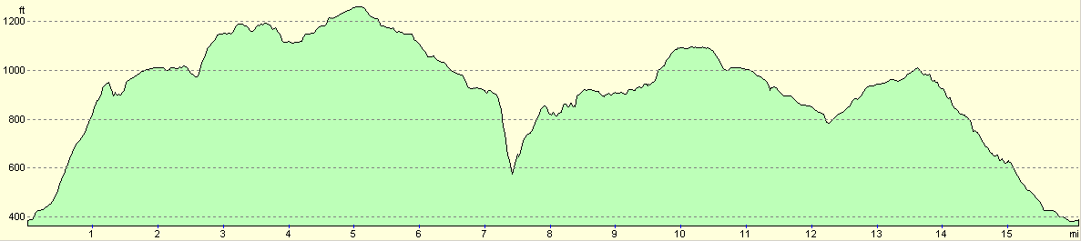
For more information on profiles, ascents and descents, see this page
Disclaimer
Please note that I take no responsibility for anything that may happen when following these directions. If you intend to follow this route, then please use the relevant maps and check the route out before you go out. As always when walking, use common sense and you should be fine.
If you find any information on any of these routes that is inaccurate, or you wish to add anything, then please email me.
All images on this site are © of the author. Any reproduction, retransmissions, or republication of all or part of any document found on this site is expressly prohibited, unless the author has explicitly granted its prior written consent to so reproduce, retransmit, or republish the material. All other rights reserved.
Although this site includes links providing convenient direct access to other Internet sites, I do not endorse, approve, certify or make warranties or representations as to the accuracy of the information on these sites.
And finally, enjoy your walking!
Nearby walks
| # | Title | Walk length (miles) |
|---|---|---|
| 11 | Stanton Moor | 2.9 |
| 12 | Darley Dale, Stanton Moor and Rowsley | 8.7 |
| 16 | Darley Dale - Winster - Matlock | 7.0 |
|
|

|