Walk #619: Cotswold Way: Painswick to Dowdeswell Reservoir
 |
 |
|
General Data
| Date Walked | 27/07/2004 |
| County | Gloucestershire |
| Start Location | Painswick |
| End Location | Dowdeswell Reservoir |
| Start time | 09.12 |
| End time | 17.34 |
| Distance | 18.2 miles |
| Description | This was a great walk, although quite strenuous with many ascents and descents to be made, some steep. The views are well worth the climbs, however. |
| Pack | Today I carried my 75-litre Craghoppers Rucksack. I did not carry my camping gear, but I did have more other assorted gear with me, which made up for most of the weight of the camping gear. |
| Condition | I am quite tired after this walk, but aside from that I feel relatively fine. The bandage on the back of my left ankle has stopped the bleeding and the chaffing, and my shoulders feel better than they did last night. All in all I could have been in a much worse condition. |
| Weather | The weather today was yet again a mixture of sunshine and cloud, with more of the latter than the former. There was no sign of the drizzle or rain that had occurred on the last two days, and despite the cloud it was quite a close, muggy day. |
| OS map | Landranger number 162 (Gloucester & Forest of Dean), Landranger number 163 (Cheltenham & Cirencester, Stow-on-the-Wold) and Landranger number 150 (Worcester & The Malverns, Evesham & Tewkesbury) |
 |
 |
|
 |
 |
|
Map of the walk
Maps courtesy of Google Maps. Route for indicative purposes only, and may have been plotted after the walk. Please let me have comments on what you think of this new format. For a detailed table of timings for this walk, please see the table file.
 |
Notes
I had another nice chat to he landlady and the other two walkers over breakfast, and I was loath to leave the place, particularly as my left shoulder was aching. The dining room has two fourteenth century columns in it (part of the old Market House), and it was a wonderfully atmospheric place to spend a night. It was with some reluctance that I retired upstairs to get changed into my walking gear and pack my rucksack ready for the walk ahead of me. This reluctance led me to have a later than usual start, and I did not hit the road until after nine.
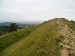
I enjoyed the stroll through Painswick as I followed the Cotswold Way out of the town; the stone of the buildings almost seemed to glow in the morning light, and most of the buildings were fine examples of the stonemasons art. The path headed along roads before heading off to pass some woodland and then cross a short section of a golf course, with a little church barely visible through the trees to the right. The Way officially heads immediately to the south of the summit pf Painswick Beacon, but as there was a trig point at the summit I decided to make a little diversion to visit it. There were clear paths across the golf course towards the summit, which was on what can only be the eroded rampart and ditch of an old fort (I later found out that they were part of the Kimsbury Camp iron age fort, dating from 500 to 100 BC). The diversion was exceedingly well wroth it as there was some superb views over the plains to the west and north, and I stood by the trig pillar letting them sink in for a few minutes.
Eventually I tore myself away from the views, and headed down across path back to the Way, being careful as the paths crossed a golf course. Once n the Way I started to head northeastwards along it, but I soon got stopped when I came across four golfers teeing off at a tee that was immediately bedside the path. They asked me if I could stop whilst they teed off, and as they had asked nicely and it was no bother I did do so. I ended up having a long conversation with them, and they appeared very friendly, which is not always the case when a footpath crosses a golf course.
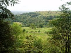
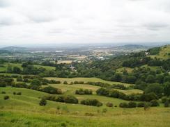
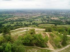
Once the golf course ended the path plunged into Pope's Wood for a short distance before reaching the A46. The road was quiet and easy to cross, and I soon found myself following a path that rose and fell through Buckholt and Brockworth Woods. It was an entertaining walk, and despite the path being through woodland and thereby cutting off the views, I enjoyed my stroll along it immensely. It was a slightly shock to suddenly emerge from the woodland at the top of Cooper's Hill and be confronted with yet another glorious view down northwestwards over Gloucester.
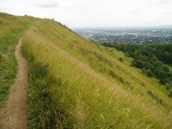
Above Cooper's Hill I met a couple of other walkers, who were resting after the steep climb along the path that runs alongside the infamous slope. They had set off from Chipping Campden on Saturday, and were camping out for the entire route. I sat down beside them and we chatted for a few minutes, before I set off down the hill to get the famous view up the slope of Cooper's Hill. This steep, grassy slope has become infamous for the annual cheese rolling, where a round Double Gloucester cheese is rolled down the slope and people run after it to try and catch it. Injuries and broken bones frequently occur, but still people volunteer to do it every May. The slope is 1 in 2 for most of the way, with a couple of 1 in 1 stretches; as I looked up at the slope I concluded that there was no way that I was going to throw myself off that slope.
From Cooper's Hill the path passed through a series of rather anonymous and uninteresting woods, following broad tracks. I found it a particularly uninteresting stretch of the route, and I listened to Radio 5 as I walked to try and maintain some enthusiasm for the walk. I resisted the temptation to visit the remains of the Witcombe Roman Villa, as I just wanted to get on with the day's walk, a decision that I now regret, although it does mean that it gives me a reason to come back to this wonderful area sometime in the future. The path eventually left the track and headed steeply uphill to reach and cross the B4010 near Birdlip, and then rising up to reach Birdlip Peak, and the first real views that I had had since Cooper's Hill. I allowed these to sink in for a few minutes, before continuing on along the Way.
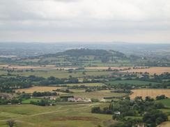
Just before I reached the Balloon Inn I stopped and chatted to a couple of retired gents who are walking the Cotswold Way in sections. I chatted to them for a long time, forgetting to log the stop in the process, and then walked on to the Balloon Inn, which marks the junction of the A436 and A417(T). I was in a very weird mood when I reached this pub, and I went in and had a pint of Deuchars and a well-needed rest. The reason for my strange mood was obvious to me - the last (and only) time I had been past the pub was when Sam and I had been driving back from seeing Graham finish his coastal walk at Churchdown hill, which was very visible a short distance away. As Sam had driven Mervan up the hill I had been very hung over and very, very depressed, for reasons that I do not want to go into now. Being at the Inn and with Churchdown Hill in sight bought back a few memories that hurt, which is strange as what had happened had not really affected me directly.
The pint of Deuchars was soon followed by another, and I sat at my table engrossed in thought, only interrupted by a lady asking me to get the SIM card out of her mobile phone. This I duly did, and, realising that I wanted to get on with the walking to try and get me out of my funk I threw my pack on and set off. Crossing the main road was fun and took me a few minutes, but afterwards I was greeted by a gentle stroll to a magnificent viewpoint on Crickley Hill, with seemingly all of Worcester and Gloucestershire laid out before me, including Churchdown Hill. A lady was sitting down having lunch, and I chatted to her about walking before heading off once again.
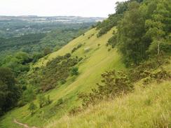
The next stretch of path was far, far better than the stretch from Cooper's Hill had been, as the Way kept to the heights and gave me some superb views over the plains to the northwest and Gloucester. The views came to an end when I reached Greenway Lane, which has to be followed for a mile inland, and then tracks and footpaths took the Way and myself northwards past Salterley Grange to Lackhampton Hill. Here the views started again, with some more superb views available over the old quarry workings. I did not divert down to visit the Devil's Chimney, a column of stone that was left by the quarrymen that is a symbol of the Cotswold Way, but continued on towards the trig point on the top of the hill. There then followed a wonderful walk along the edge of Hartley Hill, with the slope diving steeply off to the left and yet more great views, before eventually Hartley Lane is reached, which slowly led down from the top of the hill.
When I reached the A435/A436 junction at Seven Springs the route ahead was easy to follow as it was very well waymarked with new National Trail signs. After twenty minutes struggling uphill I realised, however, that I was in the wrong place on the map. I sat down right beside a National Trail way marker and started studying the map and my GPS. It soon became obvious that the way marker was on the northern side of the A436 Chatcombe Pitch, when according to the route on the map I should have been far to the south. As I was sitting right beside a brand-spanking new way marker I decided that this must have been a new route diversion to avoid the A436 Chatcombe Pitch (which is apparently a nasty road to walk along), and I later found out that this was correct.
The path headed down from Wistley Hill steeply, the gradient slowly flattening as it passed under some power lines and entered Lineover Wood, in which can be found the second-largest Beech tree in Britain. Once out of the wood the path headed down across fields, with tree never being far away, crossed the barely-noticeable bank of an old railway line and reached the A40. A pavement took me the short distance past the Reservoir Inn, and I then took a track that headed down a couple of hundred yards towards Langett B&B, where I was booked in to spend the night.
The owners made me feel very welcome, which was extra kind of them as they were full with family visitors. Instead of giving me a room they out a bed in the conservatory, which acted as an excellent little room. I was feeling quite fit, so after I had a shower I headed back up to the A40 and the Reservoir Inn, where I had a welcome meal and an even more welcome couple of pints. I could look back on an interesting and varied day's walking, and satisfaction that I still felt fit after it.
Directions
|
This walk follows the Cotswold Way, which is a well waymarked path that is soon to become a National Trail. I used a guidebook for the walk called 'The Cotswold Way', by Mark Richards (see below). This guidebook is written for north to south walkers and therefore the directions are not quite as useful for the south to north walk, but the hand-drawn strip maps are exceptionally good, and can be read easily from either direction. There was a recreational path guide published for the route, but this is out of print and will only be re-issued as a National Trail Guide once the path has officially become a National Trail. If you wish to buy the guidebook for the Cotswold Way that I used, then please click on the link to the right: | 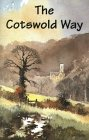 |
Distances
| From | To | Distance (m) | Ascent (ft) | Descent (ft) |
|---|---|---|---|---|
| Painswick | Birdlip | 7.5 | 1568 | 1211 |
| Birdlip | Air Balloon pub | 1.6 | 240 | 279 |
| Air Balloon pub | Dowdeswell Reservoir | 9.1 | 1299 | 1722 |
This makes a total distance of 18.2 miles, with 3107 feet of ascent and 3212 feet of descent.
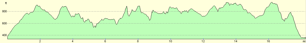
For more information on profiles, ascents and descents, see this page
Accommodation
I spent the night at the Langett B&B, Cotswold Way, London Road, Cheltenham GL54 4HG. This was a lovely B&B and the proprietors, Jennifer and Bob Cox, made me feel very welcome. It cost me twenty-five pounds to stay for the night, which was especially good as they had to squeeze me into an already-full house. They can be contacted on (01242) 820192 or by email at cox.langett@btopenworld.com.
Disclaimer
Please note that I take no responsibility for anything that may happen when following these directions. If you intend to follow this route, then please use the relevant maps and check the route out before you go out. As always when walking, use common sense and you should be fine.
If you find any information on any of these routes that is inaccurate, or you wish to add anything, then please email me.
All images on this site are © of the author. Any reproduction, retransmissions, or republication of all or part of any document found on this site is expressly prohibited, unless the author has explicitly granted its prior written consent to so reproduce, retransmit, or republish the material. All other rights reserved.
Although this site includes links providing convenient direct access to other Internet sites, I do not endorse, approve, certify or make warranties or representations as to the accuracy of the information on these sites.
And finally, enjoy your walking!
Nearby walks
| # | Title | Walk length (miles) |
|---|---|---|
| 618 | Cotswold Way: Dursley to Painswick | 16.7 |
| 620 | Cotswold Way: Dowdeswell Reservoir to Stanton | 19.8 |
|
|

|