Walk #630: Braintree to Marks Tey
 |
 |
|
General Data
| Date Walked | 14/11/2004 |
| County | Essex |
| Start Location | Braintree |
| End Location | Marks Tey |
| Start time | 09.07 |
| End time | 13.59 |
| Distance | 14.4 miles |
| Description | This was a fairly straightforward walk between the two towns, following in part the Essex Way. |
| Pack | Today I carried my 30-litre Karrimor HotRock rucksack, which was filled with two litres of water, a spare fleece, waterproofs and various electronic gadgets. |
| Condition | My legs feel slightly tight as I wore my tight leggings for the first time since the Spring. The undersides of my feet ache slightly as well, which is probably to be expected, as I have not done much walking recently. Aside from both of these points, I feel fine. |
| Weather | Today was a nice, crisp, sunny day. Initially it was quite cold, and I was in need of a woolly hat to stop too much heat escaping from my head. There was only a little breeze but this was quite chilly when I was exposed to it, and there was no sign of any rain all day. |
| OS map | Landranger number 167 (Chelmsford, Harlow & Bishop's Stortford) and Landranger number 168 (Colchester, Halstead & Maldon) |
 |
 |
|
 |
 |
|
Map of the walk
Maps courtesy of Google Maps. Route for indicative purposes only, and may have been plotted after the walk. Please let me have comments on what you think of this new format. For a detailed table of timings for this walk, please see the table file.
 |
Notes
I had not been doing much walking recently for personal reasons, and I therefore decide that it would be best to get myself into walking again slowly. I also did not want to have to drive too far, and so I soon decided that it would be nice to do this walk, which has been on my list of walks to do for a few months. As it is less than an hour drive away from my home I could therefore set off reasonably late, and I had an unhurried drive along the minor roads to Braintree, where I parked at the car park beside the station, which is fortunately free to park at on Sundays.
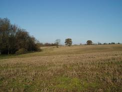
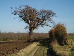
The initial walk out of Braintree was along roads, and I was quite glad when I found myself able to leave the road and join a footpath that crossed the tiny River Brain beside a smelly sewage farm. The next section of walk followed the river southwards along a path that in places was not easy to discern. The path soon crossed the A120, which was on the level, and due to heavy traffic I had to wait for a frustrating couple of minutes before I got the opportunity to cross. Once on the other side the path was easier to follow as it again headed southwards along the eastern bank of the river, which was slowly increasing in width as I headed downstream. Due to trees alongside the river I rarely got to see it, or any signs of the village of Black Notley on the other bank.
The path ended at a road beside the attractive Bulford Mill, an eighteenth century water mill that was converted in 1813 into a corn mill, and continued producing flour until 1947. The building was pretty, with white clapperboards high up on the outside, and I was tempted to have a look around. The walk called me on, however, and so I turned left to walk eastwards towards Cressing along the road. I crossed the railway line using a level crossing at Cressing Station, and headed on towards the B1018 road. Just before I reached this I passed a farm with an old moat outside it; I was annoyed to find that I could not photograph this due to the sun being in totally the wrong position.
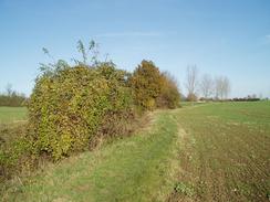
Once across the quiet B1018 I headed along another road for about a kilometre into Cressing, and then on to the little church in the village. A service was about to start, and I tried to look inconspicuous as locals in their Sunday best headed up the road towards the church. At the church I could finally leave the road and start following the Essex Way, an 81-mile long-distance path from Epping to Harwich on the coast. When I had been planning the walk I had decided to follow this path for as long as possible, as it formed an obvious route eastwards towards my destination. The path headed across fields and passed Egypts Farm before joining a road for a short distance, and then along another footpath that twisted and turned for the next mile as it headed northeastwards across fields. Every turn seemed to be a right angle, and although the Essex Way was proving easy to follow I was still relieved when I joined a road and could follow a track northeastwards past a sand and gravel pit to reach another road near Bradwell Hall.
The road did not last long, and I soon found myself on another footpath that followed the southern bank of the Blackwater River. At one point the path squeezed between the river and the fence of another sand and gravel pit before eventually leaving the fence and heading south towards Curd Hall Farm. A long track walk followed as I headed eastwards towards Coggeshall, and I soon reached the fairly spectacular Cogeshall Grange Barn, a 13th Century monastic barn. It looked interesting from the outside but it was not open to visitors, so I only saw the interior on the web when I got home, and the superb example of timbering made me wish that I had the opportunity to go inside. The barn is 120 feet long by 45 feet wide and 35 feet high to the roof apex; although it is not very large by modern standards when it was built it must have been dominating.
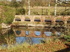
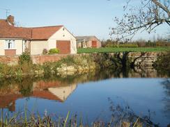
After the barn I headed downhill a short distance to St Nicholas' Chapel, which is the former gatehouse of the abbey. This was built in about 1220, and features the earliest post-Roman use of bricks in England. Again this was not open, and I continued on to the farm. When I reached this fairly ramshackle collection of buildings I was amazed to find that much of the fabric of the stonework appeared to actually be the remains of the abbey - there were bricked-up arches in the exterior walls. It really was a great place, and I could not help but take a quick look around the exterior of the buildings, despite them being in private hands. The track headed on, crossing the Black Water before curving around to enter Coggeshall.
I made my way up the hill towards the spectacular church of St Peter-ad-Vincula, a classic wool church in the Perpendicular style. I walked around the exterior of this for a few minutes admiring the architecture, before rejoining the road outside and then rejoining the Essex Way. The next kilometre was easy going until I reached Houchin's Farm; I climbed up the bank beside the farm to be greeted with a large moat in front of me. I had no idea what this was for as there were no buildings immediately beside the moat, but it was a nice and interesting sight. I walked along to the far side of the banking, and had a little self-inflicted difficulty getting down the steep banking and over the ditch at the bottom before progressing on along the path.
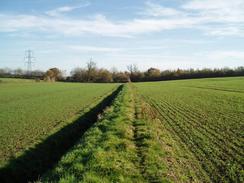
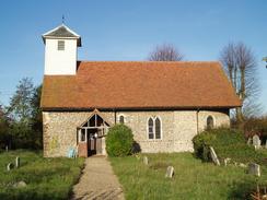
Shortly after this I left the Essex Way and started heading eastwards along local footpaths. These were quite indistinct and I soon realised that I was heading too far south. Instead of backtracking to find the proper route I decided to press on, and found myself diving through a gap in a hedge, only to slide down into a ditch on the other side. Cursing, I pulled myself out only to discover that I had two thorns in my right hand, one in a particularly nasty position in a finger joint. I spent the next twenty minutes trying to pull it out as I walked, and after much struggling and blood it finally emerged in all its quarter-inch glory. Naturally this did not put me in the best mood, and I passed the Church at Little Tey without showing my usual interest in church architecture.
I soon met the A120 on the western outskirts of Marks Tey, and I started walking eastwards along it towards the railway station. There was a train due relatively soon, and as I did not want to have to wait an hour for the next one, I put a little spurt of speed on to get myself there. As I climbed the road bridge over the Colchester to Chelmsford railway line I got a nice view of Marks Tey church a short distance away over a couple of fields, and this cheered me up slightly for the last few hundred yards to the station. I purchased a ticket and was relieved that I had got to the station about nine minutes before the train was due. The journey back was quite good, and we arrived at Witham in time for the connection to the next Braintree train.
This walk has opened up several others for me to do in this area; the most obvious one is to head east for six miles to Colchester, connect up with my coastal walk, and then head north to Manningtree, again connecting up with my coastal walk. Another walk would be to walk northwards from Marks Yet to Sudbury, and get the train back. That would open up another walk from Sudbury to Bury St Edmunds, completing another link in my map of walks. As all of these walks are quite local to me I will probably leave them to do as fillers, to be done when I do not have time to do a longer drive.
Directions
This walk starts off at Braintree railway station. Leave the station building and turn right to start walking eastwards down Station Approach. The road soon curves to the left and reaches a crossroads. Here turn right down Rose Hill; the road passes under the railway line, and shortly afterwards when a double roundabout is reached continue straight on, taking Skitts Hill Road. This winds around in a rough southerly direction for a few hundred yards, and when a sharp right-hand bend is reached turn left along a little track. This heads downhill, passing a sewage works before crossing the tiny River Brain on a bridge. Once on the eastern bank of the river turn right and follow a footpath that heads south alongside the river; do not divert off uphill to the left, where there is a more obvious path. The path continues on for a few hundred yards until the A120 is reached. The path climbs up some steps to the carriageway, which has to be carefully crossed before descending down back to the river on the other side.
The path is easy to follow as it heads southwards beside the river, which is never really in full view due to the adjacent hedges and trees. A little over a kilometre after the A120 the path ends at a road beside Bulford Mill. Turn left to join the road and follow it as it curves to the right and then the left, to reach a level crossing over the Braintree to Witham railway line by Cressing Station. Continue on along the road until it ends at a T-junction a few hundred yards further on. Here turn right and follow the road as it curves around to meet the B1018 road. Turn right along the B1018 and then almost immediately take the first road off to the left, which heads northeastwards into the little village of Cressing. When the road ends at a triangular junction by a little green, turn right and walk south along the road until Cressing Church is reached.
From here the route I followed joins the Essex Way for almost the rest of the day; this path is well waymarked and the route was for the most part easy to follow. Walk past the church and then immediately turn left to start following the Essex Way along the hedge separating the field from the graveyard. The path heads northeastwards across a field, making a little jink to the right for a few yards to meet the end of a rough track. Turn left along this track and follow it past Egypts Farm to reach a road. Turn right along this road and after a hundred yards take a footpath that leads off to the left. This heads northwards towards an isolated patch of woodland; just before this is reached the path turns sharply to the right to head slightly north of east for a few hundred yards until, once it is clear of the eastern edge of the woodland, it turns to the left to head northwards once again.
Again, after a couple of hundred yards the path turns sharply to the right, and after a similar distance to the left to head northwards once again. Eventually when a drainage ditch is reached turn right and started following the southern bank of it eastwards, passing a small patch of wodland before a road is met. Cross the road, and on the other side follow the path as it joins a rough track that passes a large sand and gravel pit. The track surface is actually concrete, but a thick layer of sand covers it. The track eventually ends at a road; turn right along this road for a couple of hundred yards until it turns sharply to the right, and then turn left along a track. A few yards down this track turn right along a footpath, which heads parallel to the River Blackwater until a large pit is reached. Here the footpath squeezes eastwards between the river to the left and a fence to the right, the path is narrow and it was a tight squeeze in places.
The path follows the fence when it turns to the right to head southwards; after a couple of hundred yards turn left and then right to head south along a footpath towards Curd Hall Farm. When the footpath meets a track turn left and start following it eastwards for a mile until it ends at a road by Grange Barn on the southern outskirts of Coggeshall. Cross the road and continue on eastwards along a track, which passes a small church (part of the old abbey) before curving to pas through a farmyard and reach a bridge over the River Blackwater. After crossing the bridge turn left and follow a footpath that heads northwards to a road in Coggeshall. Turn left and walk westwards for a short distance before turning right along a small track, just before an area of grass and the war memorial is reached. The track becomes a path that heads up a slight hill, before ending at a road opposite Coggeshall Church.
At the church turn right and follow the road as it curves around to the right and descends down into a slight sip. By a stream turn left along a footpath that heads northeastwards for a couple of hundred yards to the A120. Carefully cross this road, and once on the other side rejoin the footpath as it heads northeastwards before settling on a more easterly course. The path crosses another road before passing a high bank on the left; this bank is one of the retaining banks for the old moat beside Houchin's Farm. About half a kilometre further east this route finally leaves the Essex Way; when the Essex Way heads off to the left continue straight on along another footpath that skirts to the north of Broad Green before reaching a road. Cross this road, and once on the other side continue along the footpath for half a mile until it reaches a small road in Little Tey.
Turn left along this road and walk northwards along it towards Little Tey Church. Just before this is reached turn right and join a footpath that heads eastwards across fields. This soon reaches a minor road; cross this road and continue along the footpath on the other side. When a green track is reached join this and turn right to walk southwards past some houses until it ends at the A120 on the western outskirts of Marks Tey. Turn left and walk eastwards through the village; after about a kilometre the road rises up to cross a rail bridge before dropping down on the other side to reach a roundabout. At the roundabout turn left and follow a road that leads to the railway station, where thus walk ends, after a couple of hundred yards.
Distances
| From | To | Distance (m) | Ascent (ft) | Descent (ft) |
|---|---|---|---|---|
| Braintree | Coggeshall | 9.7 | 410 | 446 |
| Coggeshall | Marks Tey | 4.7 | 66 | 72 |
This makes a total distance of 14.4 miles, with 476 feet of ascent and 518 feet of descent.

For more information on profiles, ascents and descents, see this page
Transport
There are hourly train services from Marks Tey to Braintree, changing at Witham for the Braintree branch line. A single ticket cost me £4.50, and it should be noted that you only have three minutes to change trains at Witham before the Braintree train departs. Also note that on Sundays car parking at both Braintree and Marks Tey railway stations is free.
Disclaimer
Please note that I take no responsibility for anything that may happen when following these directions. If you intend to follow this route, then please use the relevant maps and check the route out before you go out. As always when walking, use common sense and you should be fine.
If you find any information on any of these routes that is inaccurate, or you wish to add anything, then please email me.
All images on this site are © of the author. Any reproduction, retransmissions, or republication of all or part of any document found on this site is expressly prohibited, unless the author has explicitly granted its prior written consent to so reproduce, retransmit, or republish the material. All other rights reserved.
Although this site includes links providing convenient direct access to other Internet sites, I do not endorse, approve, certify or make warranties or representations as to the accuracy of the information on these sites.
And finally, enjoy your walking!
Nearby walks
| # | Title | Walk length (miles) |
|---|---|---|
| 271 | Fingringhoe to Tollesbury | 16.7 |
| 603 | Bishop's Stortford to Braintree | 18.9 |
| 635 | Marks Tey to Manningtree via Colchester | 17.4 |
|
|

|