Walk #684: Folkestone to Wye
 |
 |
|
General Data
| Date Walked | 17/07/2005 |
| County | Kent |
| Start Location | Folkestone central station |
| End Location | Wye station |
| Start time | 06.43 |
| End time | 14.55 |
| Distance | 22.1 miles |
| Description | This was a pleasant walk following the North Downs Way westwards from Folkestone to Wye. |
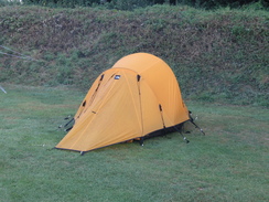
| Pack | Today I carried my 30-litre Karrimor Hotrock rucksack, containing my waterproofs, a few odds and ends such as spare batteries, my Psion 5 and two litres of water. |
| Condition | I am fairly fatigued after this walk and the underside of my feet ache considerably; the first of these was probably down to the warm temperatures and the latter due to the hard ground underfoot. |
| Weather | The day started off with hazy cloud, although it was quite warm for the time of day. As the day drew on, the cloud burnt away and it became a very warm day without many clouds in the sky. There was not much wind, which meant that it was a very warm day for walking. |
| OS map | Landranger number 179 (Canterbury & East Kent, Dover & Margate) and Landranger number 189 (Ashford & Romney Marsh, Rye & Folkestone) |
 |
 |
|
 |
 |
|
Map of the walk
Maps courtesy of Google Maps. Route for indicative purposes only, and may have been plotted after the walk. Please let me have comments on what you think of this new format. For a detailed table of timings for this walk, please see the table file.
 |
 |
|
 |
 |
|
Notes
Daylight cam early, as it does at this time of year, and although my tent protected me form the worst of it I still awoke quite early. I read for a short while, and shortly after six I decide to get up. The dew-sodden tent was soon stowed away in the boot of my car, and I arrived at Folkestone Central station well before seven in the morning. I was soon on the road, and I was surprised to find a couple of newsagents open even art this early hour as I headed northwards through the town. The climb up Creteway Down was steep, and despite the early hour I soon found myself sweating in the heat. When the path ended at a road I rejoined the North Downs Way where I had left it the previous evening, and I was dismayed to find that the views over Folkestone were very hazy, and that I could hardly make out the sea at all.
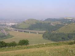
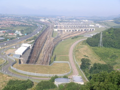
A road took me on westwards, soon passing under a large transmission mast, before dropping me down to cross Canterbury Road. This was followed by a climb up Round Hill, which had some pleasant views back towards the oddly-shaped Sugarloaf Hill and down over the A20, which passes under Round Hill in a couple of tunnels. Next came Caeser's Camp which, despite the name, is not Roman - the earthworks on the top are the remains of a Norman motte and bailey castle. On the western side of the hill I got a great view west over the entrance to the Channel Tunnel and the massed lines of the terminal. A concrete pillar stood on the hill, which I recognised as being a surveying marker for the tunnel. For the next couple of miles the path skirted the top of the hillside as it headed westwards, and I got some good views over the terminal, and I enjoyed watching the trains come in every so often, disgorging their loads of cars, lorries and coaches onto the M20.
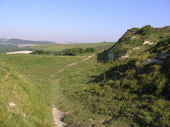
Eventually the path turned away from the terminal and started heading northwards past a field filled with blue flowers, which made an exceedingly pleasant sight. Standing in this field there was a pillbox; the grey concrete walls contrasting against the blue of the field. I went inside the pillbox to find it unusually intact, and could not help but peer out through the gun slits, wondering what it would have been like to defend this point against incoming troops. The path continued along the top of the downs for another couple of miles, before heading down a steep-sided valley and passing under an old railway line. This marked the approach to Etchinghall, which the path skirted around rather than entered. To the south of the village is a military training range, and at the entrance there was a foreboding sign warning visitors to stick to the bridleway. Hanging of this sign was an empty smoke grenade, which I picked up and examined, the base of it being black from where the smoke had poured out.
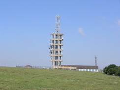
At the western end of the range I reached Tolsford Hill Radio Station, whose vast triangular concrete mast dominates the area. The walk from here across the downs was pleasant, as it slowly dropped down towards the road at Staple Farm, before climbing slowly up back onto the top of the downs once more. When the busy road across Farthing Common was reached the path crossed it and skirted through the field on the western side; when the path was interrupted by a side road I decided to have a rest, sitting down beside the road admiring the views over the plains to the west. The rest did me good, and I had a spring in my step as the path left the road and headed down Cobb's Hill, joining a road for the last half-mile into the village of Stowting. I was disappointed to see that the pub was not due to open until midday, and as I could not justify waiting half an hour for it to open I pressed on along the road that led out of the village.
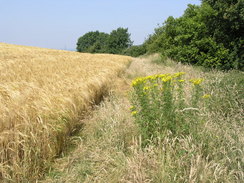
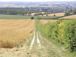
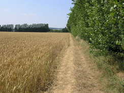
The Way soon left the road and headed along a track steeply uphill back onto the top of the downs, before skirting the top edge along a track. There were some superb views to be had over the plains to the southwest, and I could not help but admire these as I strolled along. The Way followed a road for a short distance, and I resisted the temptation to climb over a fence to visit a trig pillar in a field beside the road, contenting myself to take a picture of it instead. A long walk along a track followed, heading northwestwards along the tops of the downs. The track soon became a road, heading past Beck's Wood, after which a footpath led on towards Cold Blow Farm. The path led on along the top of Broad Downs, and in the distance I could clearly make out Wye and the hills beyond, which marked the end of the nine days walking along the North Downs Way. I still had a few miles left to walk, however, so I removed any thoughts of relaxing and pressed on along the path.
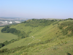
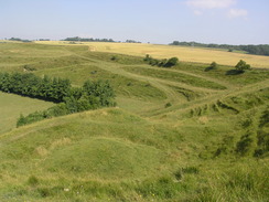
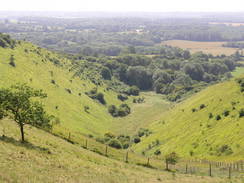
A short distance away from the path I reached the Devil's Kneading Trough, a steep-sided dry valley that was eroded in only 500 years by glacial meltwaters at the end of the last ice age, 10,000 years ago. It is a fairly spectacular gully, and I walked slowly above it examining it before continuing on along the path across Broad Downs, as it passed through the Wye National Nature Reserve. Just before the path dropped down from the hillside I reached the Crown Memorial; which is a crown shape cut into the chalk of the hillside. Standing on it I could not really make out the shape, and it was only later in the day that I could see it standing proudly on the hillside in the distance. The path dropped down off the hill and headed westwards towards Wye, passing the Nurseries of Wye College, one of the countries premier agricultural colleges.
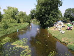
I had run out of water by this time, and after passing the church in Wye I nipped into a shop and bought a couple of small bottles. I gulped one down immediately, and put the other one in the breast pocket of my rucksack, to be drunk as a celebration once I reached the end of the North Downs Way. Wye was quite a pretty town, but I did not take much notice of it as I walked through, making my way towards the railway station. Before I reached the station the road crossed the river Great Stour, and it made for a pleasant sight, with people in the adjacent pub garden and some children splashing about in the water. When I reached the station I had a decision to make; I had about ten minutes before the next train to Ashford, but I still had one and a half miles to walk to reach the point where I had taken the Canterbury loop of the walk.
I was quite tired by this time, but the decision to continue on was easy and I strode down the road before taking the footpath that led northwestwards. Although the walk was slightly uphill there was no discernable gradient and I pushed myself on, reaching the Roman Road by Perry Court Farm earlier than I expected. A quarter of an hour later I marked the junction with the Canterbury loop of the Way, and, exhilarated, I opened the bottle of water and slugged it down in celebration. I had completed another National Trail, and I felt a great sense of achievement wash over me. I could not celebrate too much, however, as I still had to get back to Wye station. The walk back went quickly as I retraced my steps, and I reached the station with about fifteen minutes to spare before my train. I sat on a bench at the station with a very satisfied feeling offsetting the pain from my aching feet, and I waited with a warm glow that was not coming from the glaring overhead sun. Unfortunately the change of trains at Ashford International did not go well; my train got in three minutes after the previous train to Folkestone had gone, and so I had an hour-long wait at the station, during which I sat down on the platform and read a newspaper and drunk more water, dehydrating myself after the long and hot walk.
 |
 |
|
Directions
The walk is also covered in detail in the North Downs Way National Trail Guide, by Neil Curtis and Jim Walker, ISBN 1 85410 853 0, published by Aurum Press Ltd.
The only exception to this is at the beginning of the day, to get from Folkestone Central railway station to the North Downs Way on Creteway Down. Leave the station along the approach road, and when this ends at a road turn left for a few yards to a roundabout. Here turn half right, and follow the A259(T) as it heads northeastwards, with a park to the left. As it heads downhill the road curves to the right, before turning sharply to the left to head uphill to the north. One a large roundabout with the A260 is reached turn right for a few yards to a pedestrian crossing; cross the road using the crossing and once on the northern side of the road head up some steps. At the top of the steps take a short road that heads straight on; when this ends at a T-junction continue straight on along a footpath that squeezes to the left of a house. This footpath heads up Creteway Down, reaching the North Downs Way on a road at about TR230381.
Distances
| From | To | Distance (m) | Ascent (ft) | Descent (ft) |
|---|---|---|---|---|
| Folkestone Central station | Creteway Down | 1.7 | 469 | 72 |
| Creteway Down | Etchinghill | 5.3 | 922 | 1017 |
| Etchinghill | Stowting | 5.0 | 682 | 804 |
| Stowting | Wye station | 7.1 | 650 | 853 |
| Wye station | NDW junction | 1.5 | 128 | 16 |
| NDW junction | Wye station | 1.5 | 16 | 128 |
This makes a total distance of 22.1 miles, with 2867 feet of ascent and 2890 feet of descent.

For more information on profiles, ascents and descents, see this page
Transport
There are regular train sevices between Wye and Folkestone Central, changing at Ashford International station on the way. The small car park at Folkestone Central is free to park in at the weekend.
Disclaimer
Please note that I take no responsibility for anything that may happen when following these directions. If you intend to follow this route, then please use the relevant maps and check the route out before you go out. As always when walking, use common sense and you should be fine.
If you find any information on any of these routes that is inaccurate, or you wish to add anything, then please email me.
All images on this site are © of the author. Any reproduction, retransmissions, or republication of all or part of any document found on this site is expressly prohibited, unless the author has explicitly granted its prior written consent to so reproduce, retransmit, or republish the material. All other rights reserved.
Although this site includes links providing convenient direct access to other Internet sites, I do not endorse, approve, certify or make warranties or representations as to the accuracy of the information on these sites.
And finally, enjoy your walking!
This walk was mentioned in the following routes:
| The North Downs Way |
Nearby walks
| # | Title | Walk length (miles) |
|---|---|---|
| 293 | St Margaret's at Cliffe to Hythe | 17.1 |
| 294 | Hythe to Dungeness | 14.7 |
| 681 | Hollingbourne to Chilham | 22.9 |
|
|

|