Walk #702: A circular walk from Wirksworth
 |
 |
|
General Data
| Date Walked | 26/12/2005 |
| County | Derbyshire |
| Start Location | Wirksworth |
| End Location | Wirksworth |
| Start time | 08.45 |
| End time | 15.20 |
| Distance | 17.1 miles |
| Description | This was an enjoyable stroll through the limestone country immediately to the south of the Peak District. |
| Pack | Today I carried my 30-litre Karrimor rucksack filled with my waterproofs, a book and various other odds and ends. |
| Condition | My knees gave me little sporadic problems today, but nothing too severe. Aside from this I had no other problems. |
| Weather | Today was a very mixed day that was mostly overcast, with few sunny periods. There were prolonged periods of drizzle, throughout the day, although these were interspersed with some sunny periods. Towards the end of the day there was about half an hour of prolonged rain, and I was thankful that it had not occurred earlier in the day. It was quite a chilly day, and particularly so when I was in the wind, but it remained above freezing all day. |
| OS map | Outdoor Leisure number 24 (The Peak District - White Peak Area) |
 |
 |
|
 |
 |
|
Map of the walk
Maps courtesy of Google Maps. Route for indicative purposes only, and may have been plotted after the walk. Please let me have comments on what you think of this new format. For a detailed table of timings for this walk, please see the table file.
Notes
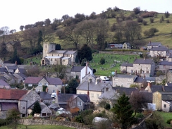
Having walked the stretch of the High Peak Trail from Longcliffe to Parsley Hay on a previous walk, I quite fancied doing the easterly stretch of this path. Public transport I n this area is sparse, and so instead of doing a linear walk I decided to do a circular one, heading to the south of the trail as that was not an area that I have walked in before. Consequently I found myself driving through Derbyshire towards Wirksworth, and after a little trouble I eventually parked in the main car park in the town, which cost a rather extortionate £4.20 for the day.
There was a persistent drizzle in the air when I arrived, and so I put on my waterproof trousers as well as my gaiters before I set off. Initially I followed a road downhill into a little valley, where the station for the Ecclesbourne Valley railway is. This railway preservation group and planning to reopen the seven-mile line to Duffield, and in the station yard there was a variety of rolling stock. I looked at this but as the drizzle was falling I decided to plod on. Initially a road headed uphill, but as I wanted to reduce the mount of road walking that I would have to do, I soon joined a footpath that promised to cut off a large stretch of road.
Unfortunately once an initial stretch of path had finished I found it hard to find where the path went, and so I ended up going too high on the hillside and I cam in contact with the road once again. This was not too much of a problem as there was a pavement, and I used this to get me to a road junction beside a pub. As I was too warm after the climb I used a half-collapsed bench outside the pub to take my fleece off, and as the rain had stopped I swapped over to using my larger, less waterproof camera.
A short walk was followed by a long walk eastwards across farmland, and from this path I got some reasonable views over the Derwent Valley to the east. It was an enjoyable stretch of path, and after I crossed a stretch of the Midshires Way that I did on a previous walk, I descended to meet the A6(T) near a bridge over the River Derwent. As the pavement was on the other, northern, side of the bridge I had to cross the road, and as it was busy I had to wait for a few minutes for a suitable gap in the traffic to occur. Once one came I quickly crossed, and made my way up to join the Cromford Canal.
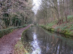
The next couple of miles saw me walk along the Cromford Canal, which was still in water but totally un-navigable. Perversely this made it a much nicer walk than most canals, as in many places there were no defined boundaries between the canal banks and the canal water, with vegetation going from one to the other, There were dead trees lying in the water, and in many places the water seemed only a foot or two deep; in one place there were some very large orange fish clearly visible swimming around. It made for a highly enjoyable stroll, and before long I was crossing the aqueduct over the Derwent and passing the Lea pump house, designed to pump water from the river up to the canal, and which is still in working order, and is occasionally open to the public. There are plans by The Friends of the Cromford Canal for the canal to be reopened and I hope it is, for is should look very spectacular if it were repaired.
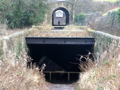
There then followed a Wharf that marked the start of he High Peak Trail, built on the trackbed of one of the most peculiar railways ever built in this country. Originally planned to be a canal across the Peak District linking the Cromford Canal with the Peak Forest canal to the north of Buxton, it was eventually built in the 1830's as a railway with inclined planes replacing the locks. After nipping into a shop to buy a giant Eccles cake I set off on up the first incline, and soon passed a catch pit in the middle of the trackbed, that had been designed to catch runaway wagons down the steep slope. It was quite a step ascent and it lasted a long time, and as I climbed up I was amazed to see runners come bolting down the slope, seemingly out of control as they ran.
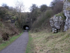
Eventually the top of the incline was reached, and I had a quick exploration of the ruined winding buildings at the top; this winding engine had been used to haul wagons up the incline whilst a cable went around a wheel in a pit between the twin tracks to other wagons to go down the slope. I soon got bored and headed on along the trail, and although there were some superb views I soon reached the next incline, which led up to Black Rocks. These tall, craggy rock outcrops are a fantastic sight, and after I resolved to come back and visit them another day I headed on passing the National Stone Centre before tackling another incline that led up to a visitors centre at Middleton Top. I nipped into here to buy a chocolate bar, and then headed off along the trail.
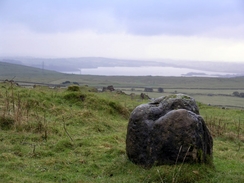
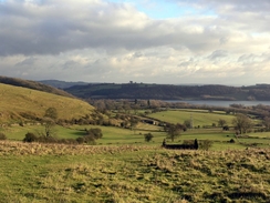
It was another enjoyable stretch of trail, and after another incline (which, although initially an incline like the others, was converted to pure steam locomotive operation, and was the steepest adhesion-powered slope in Britain). After this I approached a factory, and to the right I could see the craggy outcrops of Harboro' Rocks, on top of which there is a trig pillar. I decided to divert off the trail to visit this, and after climbing up a path I reached the rocks and the trig pillar, from here I got some superb views over Carsington Water to the south. In sunny weather it would have been much better, but in the intermittent drizzle and low cloud it left much to be desired, and, chilled, I headed down of the rocks and back to the trail.
About a mile later I reached Longcliffe, where I left the trail and headed south along a road towards the village of Brassington. This village is one that I frequently drive through, and even in the dreary weather the stone buildings seemed to sparkle. Unfortunately my route did not take me through all of the village, and instead I took a footpath that started to head southeastwards over the shoulder of a hill. The path climbed up and I reached the top just as the sun came out just at the right moment for me to get some brilliant views over Carsington Water, before descending down into the village of Carsington. This village is nowhere near as pretty as Brassington, and I quickly walked through, ignoring the lure of the village pub and headed out of the village. The main thing of note was a strange wall comprised of bricks arcs near Hopton Hall, and I wondered why the wall had been built in such a curious fashion instead of straight.
This road ended at the B5035, and I had to walk along the verge for a few hundred yards as there was a fair bit of traffic and no pavement. Fortunately this did not have to go on for too long, and soon I took a quieter road that headed off the B5035. This in turn led me to a track, and as I climbed up this it really started to bucket down with rain. For the first time in the say I was forced to put the hood of my coat up, and any views that there might have been were ruined by the rain and the rapidly-encroaching darkness. The rain did not let off as the track descended and joined a road, which I followed down into the heart of Wirksworth, and this in turn led onto another road that led towards the car park on my way. On the way I could not resist walking around the large church, and I did this before arriving at my car, wet but fairly happy after a good day's walk.
Directions
This walks starts off in the main car park in the centre of Wirksworth. Leave the car park and go down the entrance road until it ends at a T-junction with another road. Turn left, and start heading eastwards downhill along the road; this crosses a bridge over an old railway line and then starts to climb uphill once more. As it climbs the road slowly curves to the right; ignore the first footpath off to the left and take the second, which leads on eastwards, initially along a track but soon emerging into a field. The path slowly climbs uphill before ending back at the road that it came off.
Turn left and continue along this road for a few yards until it ends at a T-junction beside a pub. At this junction turn right and when the road turns sharply to the left after a few yards continue straight on along another road. Pass a road coming in from the right, and then after a short distance turn left along another footpath. This footpath heads downhill northeastwards, before curving to the right slightly to had across some parkland to the south of Wigwell Grange.
The path enters Park Wood and then crosses a stream before climbing uphill slightly; it then heads eastwards to skirt Long Wood before crossing through it and reaching a complex footpath junction, including the Midshires Way. Head straight on along the footpath as it starts to descend, passing to the north of Hankin Farm and eventually reaching the A6(T). Cross the A6(T) carefully and then head across the bridge over the River Derwent. When the A6(T)curves sharply to the right on the other side of the bridge head straight on along a minor road; this curves to the right and then the left in a short distance, before reaching a bridge over the Cromford Canal.
Turn left to join the towpath beside the Cromford Canal, and start following it northwestwards for a little under two miles until it crosses an aqueduct over the River Derwent and reaches a wharf. A little further on from the wharf there is a set of buildings at the start of the High Peak Trail; turn left at these and start heading up the incline that takes the trail westwards up onto the hills. Continue along the trail for around five miles, until SK242551, immediately before a factory is reached on the left. Here a footpath leads off to the right up onto the top of Harboro' Rocks; a option is to take the short walk up to the trig pillar at the top of the rocks, from where some superb views are available.
Continue along the trail for another mile, and just before a bridge over a road is reached turn left along a footpath. This footpath heads south, skirting Peak Quarry Farm before ending at a road. At this road turn left to start heading downhill to the southeast for a couple of hundred yards, and then on southwards down into the village of Brassington. Keep on the main road through the village as it heads downhill, and then turn left along a footpath that passes to the left of a house before entering fields. It descends diagonally across a couple of fields before rising up slightly. The path proves easy to follow as it heads southeastwards uphill before curving to head eastwards, and eventually descending down to become a track that ends at a road to the west of the village of Carsington.
Continue on this road and when it ends head straight on along another road that passes to the left of the village pub and then heads eastwards out of the village. This road curves around a bit before ending at the B5035 road; when this is reached turn left and carefully walk east along the road for a couple of hundred yards until Sycamore Farm is reached on the left. Here turn right along another road, and then after a couple of hundred yards turn left along a rough track, Summer Lane. This track climbs uphill before descending eastwards towards Wirksworth.
When the outskirts of the town is reached the track curves to the right and then the left to become a road; continue on down this road as it heads towards the centre of the town. When the road ends at a T-junction with the B5023 turn left to walk northwards through the town for a short distance; the church is away to the right and then turn right down another road towards the car park, where this walk started and ends.
Distances
| From | To | Distance (m) | Ascent (ft) | Descent (ft) |
|---|---|---|---|---|
| Wirksworth | High Peak Junction | 5.4 | 755 | 1007 |
| High Peak Junction | Longcliffe | 6.4 | 1444 | 650 |
| Longcliffe | Wirksworth | 5.3 | 584 | 1126 |
This makes a total distance of 17.1 miles, with 2783 feet of ascent and 2783 feet of descent.
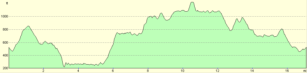
For more information on profiles, ascents and descents, see this page
Disclaimer
Please note that I take no responsibility for anything that may happen when following these directions. If you intend to follow this route, then please use the relevant maps and check the route out before you go out. As always when walking, use common sense and you should be fine.
If you find any information on any of these routes that is inaccurate, or you wish to add anything, then please email me.
All images on this site are © of the author. Any reproduction, retransmissions, or republication of all or part of any document found on this site is expressly prohibited, unless the author has explicitly granted its prior written consent to so reproduce, retransmit, or republish the material. All other rights reserved.
Although this site includes links providing convenient direct access to other Internet sites, I do not endorse, approve, certify or make warranties or representations as to the accuracy of the information on these sites.
And finally, enjoy your walking!
Nearby walks
| # | Title | Walk length (miles) |
|---|---|---|
| 11 | Stanton Moor | 2.9 |
| 12 | Darley Dale, Stanton Moor and Rowsley | 8.7 |
| 14 | Friden, Long Dale and Gratton Dale | 7.8 |
|
|

|