Walk #785: Icknield Way: Whipsnade to Harlington
 |
 |
|
General Data
| Date Walked | 27/08/2007 |
| County | Buckinghamshire, Hertfordshire, Bedfordshire |
| Start Location | Whipsnade |
| End Location | Harlington station |
| Start time | 06.25 |
| End time | 12.24 |
| Distance | 14.2 miles |
| Description | This was a pleasant stroll along the western end of the Icknield Way. |
| Pack | Today I carried my MacPac rucksack, containing my light Jack Wolfskin tent and full camping equipment. |
| Condition | I am feeling fairly good after this walk; the only problem that I have are the insect bites that I got yesterday, and which are itching. |
| Weather | The weather today was much cooler, with clouds generally replacing the bright sunshine that had predominated over the last two days. The lower temperatures made for much more comfortable walking. |
| OS map | Landranger number 166 (Luton & Hertford, Hitchin & St Albans), Landranger number 165 (Aylesbury & Leighton Buzzard, Thame & Berkhamstead) |
 |
 |
|
 |
 |
|
Map of the walk
Maps courtesy of Google Maps. Route for indicative purposes only, and may have been plotted after the walk. Please let me have comments on what you think of this new format. For a detailed table of timings for this walk, please see the table file.
 |
 |
|
 |
 |
|
Notes
I awoke this morning tired, not from the effects of yesterday's long walk, but more from the effect of a long night of interrupted sleep. Sometime during yesterday I got bitten multiple times by insects, and I frequently awoke during the night in order to got momentary relief by scratching them. On several occasions there were various wheezes, grunts, growls and yelps greeting me when I awoke, a sign of how close I was to the fence of Whipsnade Zoo. The sounds were actually quite interesting, and each time I spent the minutes until I managed to get back to sleep trying to guess which animals were making which noises.
The last time that I awoke was about five thirty, just as dawn was breaking overhead, although the sun had yet to make an appearance. There seemed little point in trying to get back to sleep at this point, so I lay in my sleeping bag listening to Radio Five and scratching the many bites over my body. I am unsure exactly when I got bitten - my rest on Ivinghoe Beacon seems the most likely candidate as there were lots of insects buzzing around me at the time - but I have bites under my arm pits, which seems like a strange place to get them.
It had been a still night with little wind, and for the first time ever the underside of the fly sheet of my Jack Wolfskin tent was sodden with moisture - this is a problem that usually afflicts my larger Westwind tent. This was much more serious in the smaller tent, as whenever I moved around I would push the mesh inner against the wet flysheet and get damp spots onto my fly sheet.
Eventually I had had enough, and slowly got dressed, paying extra attention in the process to the state of my feet, re-taping my toes in order to prevent getting any more blisters. Soon enough I was ready, and my tent was sown and packed up before the sun was even fully up. As the tent was wet I strapped it to the top of my rucksack horizontally rather than putting it into the pack, in order to hopefully allow the sun to dry it out a little more.
Yesterday I had been greeted by fog, and it was good to see that this was not the case this morning. Although it was still not fully light there was no fog, and the clear skies overhead last night had been replaced by thin clouds that seemed to promise no rain. This was pleasing, and as soon as my pack was packed up I shouldered it and headed off.
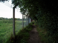
Almost immediately the path plunged through an area of woodland beside the high zoo fence, and the sparse morning sunlight scarcely managed to penetrate the vegetation. A little further on the path emerged from the trees and I soon startled a Wallaby on the other side of the fence, which hopped away from me speedily through the long grass. This was the only animal that I saw up and about, with the other visible ones all lying down in the grass. Evidently I was one of the only few animals mad enough to be up and about at this time of the morning!
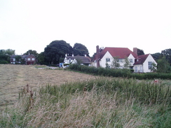
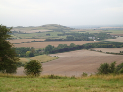
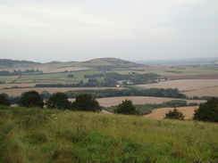
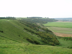
The path led on into the village of Whipsnade, which usually looks pretty but at this early hour was rather dark and dismal. The grass on the green in the centre had been cut, so I walked along the road outside it. This led me to an unusual feature - the Whipsnade tree cathedral, a large site with trees planted in the plan of a Medieval Cathedral. The path skirted the outside of this, before joining a dark sunken lane. This was a fairly boring stretch of walk, but suddenly at the end of the lane I was greeted suddenly with a spectacular view from the southern end of the Dunstable Downs ridge.
I have walked between Dunstable Downs and Ivinghoe Beacon on two previous occasions, and on both of those I had headed on a route higher up on the Downs, and I was now seeing how much of a mistake that was. The views westwards were fantastic, and in the distance there was a red hot-air balloon floating above the ridge. Underfoot the grass was damp and short, cushioning my feet as I strolled along, studying the views that were unfolding beneath me. At one point there were large columnar stacks of hay bales, and further on there were the parked gliders of the London Gliding Club.
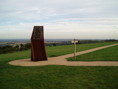
Suddenly a large steel monument came ahead of me, marking the approach to the visitor's centre. Unfortunately this also coincided with litter, and the path in this area had a fair amount of litter strewn about, including one or two disposable barbecues. One of the bins in the area was literally overflowing with bin bags, and it seems as though people had been realty enjoying the good weather over this bank holiday weekend. A little further on there was a car park, and in this were two Land Rovers. I stopped to chat to a couple of men by the cars, and they had come out here at five thirty this morning to watch the sun come up. They too were having a barbecue, but everything was on the back tailgate of the Land Rover, and there was no litter around them. It seemed like a wonderful idea, and I wished hem well as I headed on.
For a period the path follows the B4541 road northwards, staying to the west of the road as it heads northwards, with some superb views to be had. Initially it passed a car park, and as I walked along the close-cut grass my left foot suddenly went into a little hole and I went partially over on my bad ankle. The next few steps did not seem too bad, but after a couple of minutes it started to get increasingly painful, forcing me to stop at a bench so that I could tighten the laces on that foot. Cautiously I restarted, and was relieved to find that the tightened laces seemed to help the pain somewhat.
I soon reached Five Knolls, which are small burial mounds situated right on the northern end of the ridge. There were some pleasant views to be had, but I did not want to hang around for too long and so instead headed on down a steep path to reach a road on the outskirts of Dunstable. It was surprising quite how quickly the character of the path changed as it descended down to meet the road, from being a high-level scenic route to a rubbish-strewn path crossing a busty main road. There was a petrol station to the left that I was tempted to go in and get some food, but I resisted this and instead joined a green lane, a surprising thing to find inside the town.
The lane was initially surrounded by houses, but the ones on the left soon ended and the ones on the right were masked by a thick band of trees, meaning that the walk was far better than it would otherwise have been. Unfortunately the guide book did not make it too obvious when to turn off, and despite asking a dog walker it was hard to know where the correct point was. There were several track crossings that matched the description, but the hand-drawn map showed no houses on either side, and eventually I reached a cross track that looked correct. There was a post with waymarkers on leaning against the hedge, but a little investigation showed that this had actually been uprooted and hence gave no sensible idea of the correct direction.
It seemed like a good a point as any to divert off the green lane, and so I turned right and followed a path that ran alongside a hedge past Maiden Bower, a Neolithic hillfort and camp, which I could see part of the bank of through the trees. Apparently the bank has suffered significant malicious damage recently, which shows exactly how much some people care for out heritage. The path ended soon after the bower, and a track took me down alongside an old railway embankment to meet a junction of tracks beside a bridge, which I recognised as I had walked past this point on a previous walk.
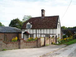
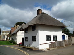
The path headed under the bridge (the old railway one has been replaced with a smaller one to carry the cycle path overhead) and joined the tarmac path that headed through the tiny hamlet of Sewell. There were a couple of picturesque buildings in the village near the farm, but the road was soon left behind as the way followed a path that led into a large field filled with long grass. It was not obvious where the exit point from the field was, and my bare legs got soaked from the long grass and thistles that I encountered as I made my way to the stile on the other side. The next stretch of path was short and enclosed but mercifully free of much of the vegetation, but this soon ended by a pond and I was forced out into a field filled with long grass and thistles.
This was far from an enjoyable stroll, especially when nettles were encountered, but as my legs were already wet I could not see much point in stopping to put my trouser legs and gaiters on. If the grass had not been wet with morning dew then it could have been an enjoyably colourful stroll past myriads of flowers, but instead it was a dreary and long plod. It was therefore a relief when the high embankment that carried the A5 was reached, and I turned right to try and find the 32 steps that the guidebook told me led up the bank to the road. I walked on until I found them, and started making my way up the steep steps.
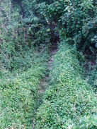
About a third of the way up the steps entered an area of scrubby trees, and I was greeted with a mass of brambles blocking the way. There was about a four foot gap under these, but with my pack on I had little way of getting past these. To make matters worse the steps rose up towards these brambles, and although I could see that the way was clear beyond them there was little chance of me safely taking my large pack off on the steps. Even if I did I doubted that I would be able to push it through and clamber after it due to the steepness of the steps.
I was therefore faced with little choice but to try and force my way through. The brambles were growing from the left and so I used my walking poles to bend most of them out the way before slowly and painfully forcing my way through. In the process I heard a slight ripping sound, but after this I was safely through and clambering up the rest of the steps to reach the A5 road at the top of the bank.
The path followed the road for a short distance past a petrol station, and I nipped into this to buy myself a pack of crisps and a bottle of Ribena to sustain me over the last few miles of this trip. By this point I was fairly fed up and just wanted the walk to end, and after re-crossing the road and finding the steps down the northern side of the embankment I plodded on, deep in thought.
The sound of my phone ringing awoke me from my reverie, and I answered it to find a friend, Mike, wanting to know if I wanted to meet up in Cambridge. Sadly I had to tell him that I was away for the day, and we chatted as I walked past a sewage works, the dank smell hanging heavy in the air. This stretch of path led to an area of woodland, and it proved slightly difficult to find the exact point at which the Icknield Way left this; eventually I found it on a track that cut through the woods.
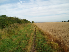
The next stretch of path crossed fields, slowly climbing before reaching a road in Wingfield. A short distance along this there was a pub, and although it was still to early in the day for it to be open I asked a man in the garden if I could sit down for a while. It was nice to get the weight of the pack off my shoulders, and I listened to the radio as I relaxed. Suddenly I hard a voice, and a man nearby was trying to get my attention From the way that he was speaking it was clear that he had had a stroke, and over the next ten minutes we chatted about the village and the path. He warned me that a nearby field was being ploughed, and I thanked him for this information.
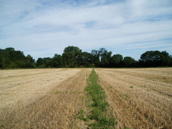
It was really nice to be able to sit down, and I was surprised to find that I had drunk hardly any water so far today, a sign of how much cooler it was then the previous two days, probably due to the cloud cover overhead. Once I set off again I found the first few hundred yards hard and the undersides of my feet were aching, but this soon wore off as the path left the road and headed across a field. In the next one I came across the ploughing that the man had warned me about, and as the tractor came past me I could see that it would be hard to walk across the deep furrows and rough ground. As there appeared to be a wide border around the edge of the field I decided to walk around this instead, which made for an easier if not longer walk.
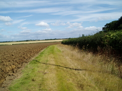
The footpath dropped me off on a main road opposite a golf course, and as the road was busy I had to carefully walk along the verge, and at a bend this was quite difficult and I had to take care. It was a relief when a road led off the main road towards a pretty little church, but I did not stop off in this and instead walked on around the outside and then along a path beside a hedge down a slight hill. A series of paths took me northwards to the B579, before crossing a series of small fields climbing northwestwards towards the village of Toddington. At one point this was along a path enclosed by hedges, and the encroaching nettles stung by bare legs that were still damp from the wet grass of earlier in the day.
Toddington appeared to be a pretty village, and the path out of it took me past a series of paddocks and a mound called Conger Hill, the motte of a 13th Century castle. Traditionally every Shrove Tuesday the local children run out to the hill as the church bells are rung to hear the 'Old Woman of Conger Hill' frying pancakes - apparently this is the vibration of the church bells. The path descended to cross the B530, before joining a minor road to cross a bridge over the M1 just to the north of Toddington services. The traffic roaring underneath made me realise quite how insulated you become from modern life on a camping trip, and I considered this as I headed along a track that soon became a rough path across a field.
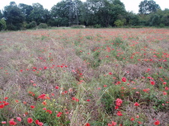
By a power line pylon I met a man walking in the opposite direction, who turned out to be the warden for this stretch of the Icknield Way. He asked me about what I thought of the state of the oath, and I told him about the atrocious state of the path near the A5, which was out of his area. A little further on there was a large patch of poppies that looked magnificent, and I walked through these to reach the bridge under the railway line.
It had been my intention to walk on to a footpath that would take me to Harlington, where there was a railway station, but immediately after passing under the bridge I found a footpath sign skirting the railway embankment northwards. I had not spotted this on the map, and as it seemed like a better route I followed it northwards as it followed the embankment before crossing a field and entering the southern edge of the village. I asked some locals who told me of a shortcut along paths through the village, and as I followed this I passed a couple of houses with life-sized figures outside, one dressed a a Mrs Mop.
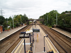
I arrived at the station and immediately bought a ticket, only to be told that a train as due immediately, so I ran across the footbridge and arrived on the platform about a minute before the train pulled in. To get back to Cambridge I had to go into King's Cross, and as I sat on the train amongst people going to the Notting Hill carnival I looked back on what had been a superb three day's walking. Not only had I finished the Ridgeway, but I now only have one twenty-mile day to do before I complete the Icknield Way, which I only started in early July.
 |
 |
|
 |
 |
|
Directions
|
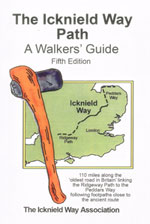
The walk is covered in detail in the Icknield Way Path: A Walkers' Guide, by The Icknield Way Association, ISBN 0 9521819 2 4 published by Icknield Way Association. Click on the image to the right to go to the Amazon page for the book. The association also have a web presence at http://www.icknieldwaypath.co.uk/index.php. The exception to this is at the end of the walk. After passing under the railway bridge a mile to the south of Harlington, immediately turn to the left to follow the eastern edge of the railway embankment northwards. After about a third of a mile the path turns to the right to head across fields before ending at a road. Here turn half-left along the road for a few yards, before turning right up a path between houses. This ends after a short distance at Leys Road; follow this as it heads northwards and climbs up a slight hill. Near the top of the hill turn left along a short road and then right, to join another shoot path that parallels the railway line before ending at Station Road. Turn left along this to cross the railway line on a bridge, and immediately on the other side turn left to walk down to the forecourt of Harlington Station. |
 |
Distances
| From | To | Distance (m) | Ascent (ft) | Descent (ft) |
|---|---|---|---|---|
| Whipsnade Zoo | Dunstable Downs | 2.7 | 200 | 105 |
| Dunstable Downs | Wingfield | 6.0 | 354 | 643 |
| Wingfield | Railway bridge | 4.6 | 315 | 433 |
| Railway bridge | Harlington station | 0.9 | 36 | 52 |
This makes a total distance of 14.2 miles, with 905 feet of ascent and 1233 feet of descent.
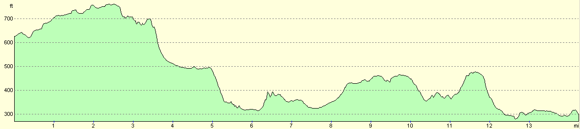
For more information on profiles, ascents and descents, see this page
 |
 |
|
Disclaimer
Please note that I take no responsibility for anything that may happen when following these directions. If you intend to follow this route, then please use the relevant maps and check the route out before you go out. As always when walking, use common sense and you should be fine.
If you find any information on any of these routes that is inaccurate, or you wish to add anything, then please email me.
All images on this site are © of the author. Any reproduction, retransmissions, or republication of all or part of any document found on this site is expressly prohibited, unless the author has explicitly granted its prior written consent to so reproduce, retransmit, or republish the material. All other rights reserved.
Although this site includes links providing convenient direct access to other Internet sites, I do not endorse, approve, certify or make warranties or representations as to the accuracy of the information on these sites.
And finally, enjoy your walking!
This walk was mentioned in the following routes:
| Icknield Way |
Nearby walks
| # | Title | Walk length (miles) |
|---|---|---|
| 127 | Hitchin to Luton | 13.2 |
| 129 | Dunstable to Tring | 14.1 |
| 130 | Tring Station to Hemel Hempstead Station | 8.0 |
|
|

|