Walk #837: Newbury to Great Shefford
 |
 |
|
General Data
| Date Walked | 18/03/2009 |
| County | Berkshire |
| Start Location | Newbury business park |
| End Location | Newbury business park |
| Start time | 09.17 |
| End time | 17.15 |
| Distance | 19.2 miles |
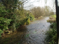
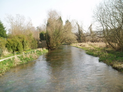
| Description | This was a lovely walk, roughly following the River Lambourn northwestwards from Newbury to Great Shefford. |
| Pack | Today I carried my 30-litre Karrimor rucksack, filled with waterproofs, a fleece,a book and other odds and ends. |
| Condition | I feel absolutely fine after this walk. |
| Weather | Today was a lovely, sunny day with scarcely a cloud in the sky. It was quite warm for the time of year. |
| OS map | Landranger number 174 (Newbury & Wantage, Hungerford & Didcot) |
 |
 |
|
 |
 |
|
Map of the walk
Maps courtesy of Google Maps. Route for indicative purposes only, and may have been plotted after the walk. Please let me have comments on what you think of this new format. For a detailed table of timings for this walk, please see the table file.
 |
 |
|
 |
 |
|
Notes
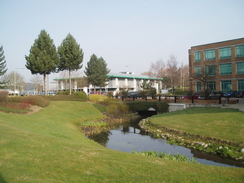
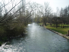
Sencan had another meeting in Newbury today, and as she is not quite happy with driving long distances, I agreed to drive her once again. The company she was visiting is based on the Newbury business park on the eastern side of the town, and I decided to start the walk from there. The River Lambourn flows just behind the park, near to it's confluence with the River Kennett. This looked like a good way of getting out of the town, so I followed a good path along its banks. After about half a mile the path diverted onto a local road which took me through Shaw,a village that has been subsumed within Newbury.
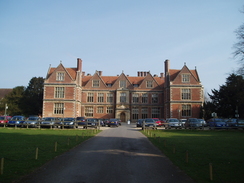
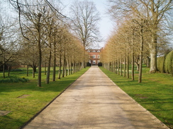
The gates leading into the red-brick, Elizabethan and Grade-1 listed Shaw House were open. This was a pleasantly symmetrical building built in 1581, and it looked as though it was in use for some sort of conference - lines of cars were neatly lined up on front of the house, and a sign displayed 'car park full'. It was a school for a long time, before a 22-moth, �6-million restoration took place on it.
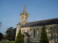
Adjacent to the house was St Mary's Church in Donnington was an attractive, stone-built structure, with tall, narrow vertical slit windows and some ornate stonework, all topped off with a stumpy spire on top of the tower. All in all, it was fairly fancy for a small parish church. The website above tells us why - it was built in 1841, when the vicar had the old Saxon church demolished to be replaced with this less draughty one!
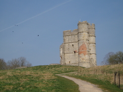
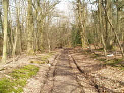
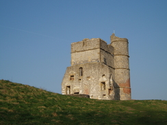
A road led me over a bridge crossing a branch of the A34(T) , and then on to a smaller main road in Donnington. A smaller road soon ended and a driveway took me up towards Donnington Castle. On the way, I stopped to chat to an elderly woman for a few minutes about the beauty of the local area. I had not known what to expect from the castle, and I was surprised to see from the small car park at the bottom of the mound that some substantial stonework remained. Although it was tempting to go up and have a look around, instead I circuited around the bottom, passing a lovely girl who was sitting on the grass above me, and then entered Castle Wood.
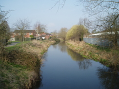
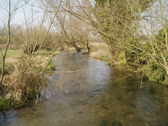
This part of my route followed the Lambourn Valley Way, a path that I would be following on-and-off for most of the day. This took me down to cross the A34(T) proper, and then into the pretty little hamlet of Bagnor, complete with expensive-looking houses. From Bagnor Manor a track took me northwestwards across the edges of fields; it was a pleasant if unspectacular stroll, and I listened to more Escape Pod stories as I strolled along. To my left was the River Lambourn, although for most of the time it was out-of-sight behind hedges and trees.
I only got to see the river again when the path ended at a road in the hamlet of Boxford. A couple of small bridges took me across a couple of tributaries of the river, and then a path took me between houses and over the trackbed of the old Lambourn Valley Railway, now subsumed into the gardens. More footpaths took me uphill, where I passed a car parked on a track. Next to this were two men and, sticking out of the ground with glinting, mischievous eyes, a ferret. On the ground lay a couple of dead rabbits. I have never seen a ferreter during one of my walks before, so I stopped for a quick chat.
Some fairly undistinguished paths tool me down to a bridge over the M4, and then steeply through some woodland to a road and into Welford Park, and although the grounds were typical, well-laid out parkland, I did not get to see the main house. Soon I reached Weston, where paths took me across a series of bridges that crossed tributaries of the river.
Near Elton Farm stood a brand-new, large house; lived-in but with the grounds around it filled with the usual builder's paraphernalia. Columns supported a wide porch, and in front of this stood a dry fountain. After passing this the path took me through a farmyard, and I then rejoined the old railway line for a short period towards Great Shefford, although the trackbed soon became totally obliterated by ploughing.
I could have walked further, but I was well aware that I had to get back by the time that Sencan's course finished before five. Instead, I walked down through the village towards the pub marked on the map. This was the Swann Inn, and I was made to feel welcome the moment I entered. The interior was neat and tidy, so after ordering a pint of orange juice and an omlette I slipped out the back, where there was some seating beside the river. It really was a lovely spot for a break, and the river burbled quietly passes as I supped.
The route that I took back was identical for the first few miles, following the old railway trackbed and footpaths as far as Weston. Here, however, I realised that time was pressing, so instead of following the Lambourn way back over the fields I headed along the road through Welford. This made for a pleasant stroll, and I was soon passing the elegant brick gateposts guarding the entrance to Welford Park and passing under the M4. A stiff climb uphill led me back to the Lambourn Way, and I followed the path downhill into Boxford.
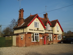
Again, from here I followed the Lambourn Way as it skirted the edge of the fields southeastwards. The stroll was not to interesting, but was at least easy along good paths and tracks. Bagnor was a bit busier than it had been in the morning, although that was not saying too much. I resisted the temptation to nip into the Blackbird pub, and strode uphill once more, crossing the A14(T) and the golf course to reach Donnington Castle once more.
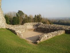
This time I risked the time, and diverted uphill to visit the castle. This was well worth the effort, and evidently many other people held the same opinion. The large extant remains are the twin towers of the gatehouse; tall and dominating the area around it. Construction of the castle started in 1386, and the castle lasted for under 300 years until it was destroyed during the civil war. Springing out from the gatehouse are low walls that detailed the layout of the castle, with neatly-mown grass around it. The whole effect was lovely in the sunshine.
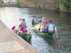
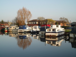
From Donnington I descended down to cross the River Lambourn for a final time, and then walked towards the centre of Newbury. I have always liked this town it is typical middle-England, and today was no exception. I walked straight through the centre of the bustling, lively town until I met the canal, and then walked back along this eastwards towards the business park. This was a stretch of the canal that I had walked the previous day, and it was equally pleasant today. Boats of varying sizes lined the banks, and it seemed a shame when I had to divert off to walk through to meet Sencan at the car. It had been a very enjoyable day's stroll; fulfilling despite being short.
 |
 |
|
 |
 |
|
Directions
This walk starts off at the Newbury business park, on the eastern side of the town. Leave the business park and turn left to walk eastwards along the A4 for a short distance until a bridge over the River Lambourn is reached.Just before this bridge turn left along a footpath that runs along the western bank of the river. After a few hundred yards a wooden footbridge over a river is reached; cross this bridge and continue on along the eastern bank of the river. This path ends at Walton Road; turn right and follow this for a short distance until it ends at a T-junction with Kiln Road. Turn left along Kiln Road and follow it westwards for a short distance until it meets the B4009 Shaw Road.
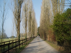
Carefully cross the B4009 and continue on along Church Road in Shaw. This passes the church and then curves to the right, passing a school before ending at a T-junction with Love Lane. Turn left and follow Love Lane westwards for half a mile as it crosses over a dual carriageway road on a bridge. When the B4494 road is reached in Donnington cross it, and continue on for a short distance down a lane. After a hundred yards a crossroads is reached; turn right along a lane and start following it uphill. This is the Lambourn Valley Way, which will be followed all the way to Great Shefford. This soon ends, and a tree-lined surfaced track continues on northwestwards. This ends at a car park below Donnington Castle; go through the car park and continue on along a track that heads through Castle Wood, before exiting to cross a golf course and reach a footbridge over the A34(T).
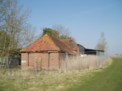
On the other side of the bridge a track turns to the left and heads steeply downhill. At the bottom turn right, and follow a gravel track into Bagnor, where it joins a surfaced road. Shortly after this curves to the right and crosses the Winterbourne Stream, turn left along a surfaced track past farms. When the entrance to a manor house is reached, turn half-right, still following the Lambourn Valley Way. This follows a track uphill. Continue along this track for a couple of miles; initially it runs along a green lane, before heading through a couple of areas of trees and then following the edge of a field past a couple of old barns northwestwards to Boxford.
When the footpath ends at a road in Boxford, turn left along this road as it crosses a couple of tributaries of the River Lambourn. When this reaches a T-junction cross the road, and take a footpath that continues straight on westwards between houses. This crosses an old railway trackbed and then climbs uphill across a small field. At the top cross a stile and join a road. Turn right along the road for a few yards, and then turn left along a track that heads uphill to the left. At the top of the hill the path converts to the right; two-thirds of a mile after the first road another road is reached.
Cross this road and follow a footpath northwestwards. It skirts Tullock Farm before reaching a bridge over the M4. Cross this, and continue along the footpath on the other side. Soon this reaches Buck's Copse; the path heads steeply downhill from here to another road. Cross this road, and continue on the footpath northwestwards through Welford Park for half a mile; it climbs uphill before slowly dropping down to another road in Weston. Cross the road, and take a footpath on the other side that soon crosses footbridges over tributaries of the river Lambourn. On the far side of the last one, turn left and follow a footpath that heads northwestwards, squeezing past a large house and reaches the end of a road. Turn left, and follow a track that curves through Elton Farm.
Follow this through to the old railway trackbed, and then turn left to follow this northwestwards. When the hedges on either side end, continue on across a field, passing between a series of farm buildings until the A338 road is reached in Great Shefford. Turn left down this and follow it as it crosses the River Lambourn; when it curves sharply to the left, a pub is on the left.
On the way back I followed the same route for the first mile and a half until the road is reached in Weston. Here, instead of following the footpath back through Welford Park, turn left and follow the road eastwards as it heads through Welford. Continue on for a couple of miles as the road passes under the M4 and then starts to climb up Rood Hill. Eventually the Lambourn Valley Way is reached once again; turn left and follow this as it descends down towards Boxford.
Follow the Lambourn Valley Way for over three and a half miles until the B4494 road is reached in Donnington. Turn right down this road for half a mile until it reaches a large roundabout with the A4. Continue straight on along Oxford Road, which curves to the right and becomes Northbrook Street. This heads south through the centre of the town until the Kennet and Avon canal is reached once more.
At the canal turn left, and follow it as it heads eastwards for three-quarters of a mile until the towpath crosses over the canal on a large wooden cycle bridge. Here turn left, and walk past a pub to reach the A4. The Newbury business park is a short distance away on the right.
Distances
| From | To | Distance (m) | Ascent (ft) | Descent (ft) |
|---|---|---|---|---|
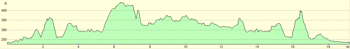
| Newbury business park | Great Shefford | 9.7 | 489 | 604 |
| Great Shefford | Newbury business park | 9.5 | 719 | 604 |
This makes a total distance of 19.2 miles, with 1208 feet of ascent and 1208 feet of descent.
For more information on profiles, ascents and descents, see this page
 |
 |
|
 |
 |
|
 |
 |
|
 |
Disclaimer
Please note that I take no responsibility for anything that may happen when following these directions. If you intend to follow this route, then please use the relevant maps and check the route out before you go out. As always when walking, use common sense and you should be fine.
If you find any information on any of these routes that is inaccurate, or you wish to add anything, then please email me.
All images on this site are © of the author. Any reproduction, retransmissions, or republication of all or part of any document found on this site is expressly prohibited, unless the author has explicitly granted its prior written consent to so reproduce, retransmit, or republish the material. All other rights reserved.
Although this site includes links providing convenient direct access to other Internet sites, I do not endorse, approve, certify or make warranties or representations as to the accuracy of the information on these sites.
And finally, enjoy your walking!
Nearby walks
| # | Title | Walk length (miles) |
|---|---|---|
| 74 | Wooton Rivers to Kintbury | 16.4 |
| 75 | Kintbury to Newbury | 9.3 |
| 99 | Newbury to Reading | 19.6 |
|
|

|