Walk #885: Ventnor to West Cowes
 |
 |
|
General Data
| Date Walked | 14/02/2011 |
| County | Isle of Wight |
| Start Location | Ventnor |
| End Location | West Cowes ferry landing |
| Start time | 08.41 |
| End time | 15.34 |
| Distance | 18.0 miles |
| Description | This was a pleasant walk cutting south to north across the Isle of Wight. Initial high ground with fabulous views gives way to a flatter stroll along old railway lines. |
| Pack | Today I carried my 30-litre Karrimor rucksack, filled with water, my waterproofs, a couple of books and other odds and ends. |
| Condition | I feel absolutely fine after this walk, with no problems to report. |
| Weather | The day was mostlyu sunny, with some clouds gathering towards the end of the day. The wind was fortunately not too strong, and was never chilling. All in all it was a wonderufl day for a walk, especially after a wet week. |
| OS map | Landranger number 196 (The Solent & The Isle of Wight, Southampton & Portsmouth) |
 |
 |
|
Map of the walk
Maps courtesy of Google Maps. Route for indicative purposes only, and may have been plotted after the walk. Please let me have comments on what you think of this new format. For a detailed table of timings for this walk, please see the table file.
 |
 |
|
Notes
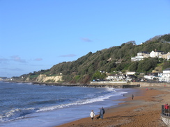
I wanted to visit the highest point on the Isle of Wight on St Boniface Down before I leave the area. Therefore Sencan dropped me off in Southampton early this morning so that I could catch the RedJet over the Solent. A couple of bus journeys followed, and I eventually reached Ventnor before nine. I nipped into the nearby Co-Op before starting off on the walk. It seemed like a good idea to see the sea before starting the climb, so I headed down to visit Ventnor seafront.
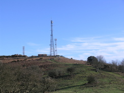
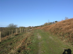
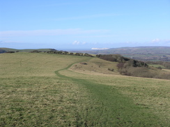
It was a beautifully sunny day, and I got an urge to follow the cliffs around the southern side of the island. Instead, and slightly reluctantly, I climbed back up into the towns. The route through the town was not very obvious, even on my 1:25,000 map, but eventually I found my way to the place where the footpaths head up onto the down. I took an obvious path that headed uphill, before skirting along the northern side of a dry valley. It soon became obvious that this was not the route I had meant to be on, and as I approached the head of the shaded dry valley, with the masts of the radar station above me, I took a path that angle uphill to reach the proper path.
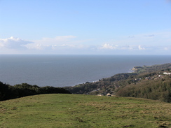
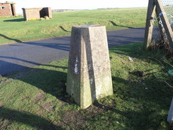
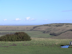
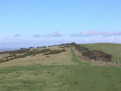
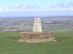
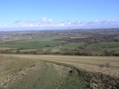
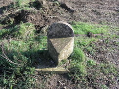
The views from the path out to sea were superb, and I paused to let them sink in. This was a good thing, as soon the path curved around to reach the road that runs along the top of the down and the views out to sea were obscured by the buildings of the radar station. The trig pillar sat just outside the boundary fence beside the road, although it was hard to get a good photograph due to the angle of the sun and a car that had been parked alongside. A little further on was the point that, according to various sources, is the high point of the down. This was on the road just outside the fence, and hence was hardly the best county top I have visited. It seemed like some of the ground inside the fence may have been higher, but it would not have been by much, if any height, and was inaccessible anyway.
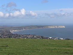
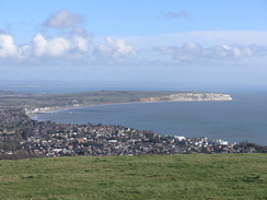
A car parked nearby as I was admiring the view, and four people got out. I soon caught up with them, and started talking to an older gentleman who was walking with the aid of a cane. We chatted as we walked along the track towards the car park, the company adding to sense of exhilaration gained by the views. He had walked all over Britain and the entire coastline of northern France; we parted as we approached the car park so I could 'bag' what might well be the county top by some tumuli. The views were superb, with the cliffs of Culver Down and Bembridge Down visible in the distance.
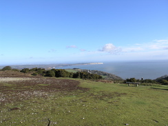
I caught up with the other walkers soon afterwards, and I ended up strolling along with the gentleman, leaving his companions far behind. He knew all about the local area, and pointed out various items of interest in the valleys below. The views were still superb, with Sandown Pier in the distance. The man told me that when Shanklin pier was washed away in a great storm in 1987, the local children had a great time collecting all the pennies from the slot machines on the pier, the coins having been strewn over the shore. It was a fascinating chat, and it was a shame when I had to head off to climb the short distance to visit the trig pillar on Shanklin Down.
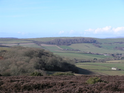
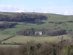
Again the views from here were good, and I let them soak in for a while, knowing that the rest of the day would be spent in the valleys. I returned to the path and started along a good path along the ridge of St Martin's Down; the frontage of Appuldurcombe House was visible on the hillside in the distance. Unfortunately the path soon headed off past an old quarry; it was muddy and more that a little slippery, meaning that I had to take care. It was a relief when the gradient slackened and I could get into my stride.
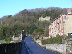
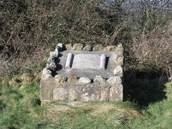
Unfortunately this did not last long as the path entered a band of trees. Here two routes diverged; the bridleway heading downhill and the footpath remaining level. I chose the latter, which was possibly a mistake as there was a steep and muddy stretch - it was not a long drop, but was exceptionally muddy with no foothold. Eventually I took the coward's way out and ran down. A good point about the footpath was that it passed a little stone memorial stating that this was the site of Cook's Castle, although there was nothing to show that there had been a castle - no obvious walls or even bumps and hollows. A little research shows that it was built as a mock castle to be viewed from Appuldurcombe House, which is probably why only a little information could be found about it on the 'net.
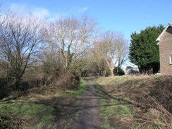
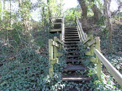
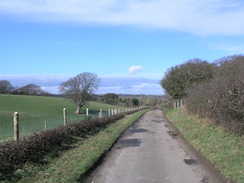
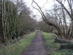
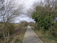
The path became a road that then led on into the pretty little village of Wroxall, although I did not see much of it as, after crossing a narrow bridge, I took a path that headed down into an old railway cutting. This was part of the old Newport to Ventnor railway line that ran between Shanklin and Ventnor, which closed in 1966. The path squeezed past an industrial building before joining the old trackbed. This is now a path that runs all the way to Shanklin, but I soon left it, descending down a long flight of wooden steps to meet the main road.
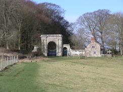
Another road led towards the entrance of Appuldurcombe House, which I had been viewing for the last hour or so. The impressive-looking building is a bit of an illusion; the main part of the eighteenth century building is mostly a shell after many misfortunes, including damage from a German mine. It is run by English Heritage, but was not due to open until April. There were lots of people walking around the place despite it not being open, and I had company as I strolled across the parkland.
An impressive gateway eventually blocked the trail ahead; the unlocked small gateway was blocked by a good few inches of muddy water. I managed to wade through without getting my feet wet, but the couple behind me - both of whom were wearing trainers - gave up. It is a shame that this part of the path was so boggy, because what followed was a good trail leading downhill. A man was laying a hedge further down, the plastic pipes that had protected the young trees lying discarded in piles. He was evidently an expert in his job, and expressed relief at being so near the end of what had been a literally long job.
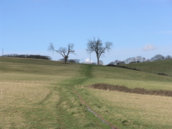
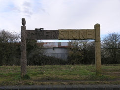
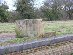
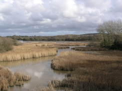
The next few miles were fairly pedestrian, the only things of note being a stone marking the source of a river (the sea being all of six miles away) and the impressive-looking Great Budbridge Manor. Things started to get more interesting as I reached the course of the old Newport to Sandown railway line at the site of the old Merstone station. The old island platform was still extant, and was adorned with a half-wooden, half-stone signboard and a set of luggage carved from a stone block. This marked the start of another railway trail, but surprisingly the path soon diverted off the old railway line to take tracks that paralleled it a hundred yards or so to the south. I am not sure why this was, as it rejoined the old railway trackbed for the last stretch to Blackwater.
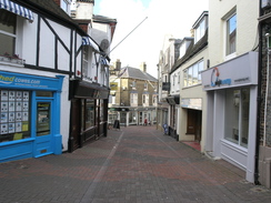
The rest of the route into Newport was fairly pedestrian, following the old trackbed to the southern outskirts of the town, then roads into the very centre. It was tempting to stop off for a drink, but I was very muddy after the earlier travails on the hills and did not feel like entering a city-centre pub in such a mess. I had got to know Newport fairly well whilst waiting for busses over the last month and I did not feel like exploring, so instead I pressed on along the roads out of the town.
It was a relief when I joined yet another old railway path, this time the line between West Cowes and Newport. This had been my first walk on the island about five weeks before, and it felt good to be walking it again, if only in the opposite direction. There felt to be a certain symmetry in finishing my walks around the Isle of Wight on the same footpath I had started.
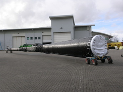
Some turbine blades lay outside the Vestas Factory, and a little further on I passed their new research and development building, a massive structure that had been built in a ridiculously short time. My feet were starting to ache by now, and I abandoned all thoughts of extending the walk by walking some of the coast to the west of Cowes. Instead, when the footpath ended I continued along the old trackbed for a short distance before joining roads for the last mile or so into Cowes. It was a worse route than the one I had taken on the earlier walk, although I did get to look down into the approach cutting to the old railway tunnel under the town.
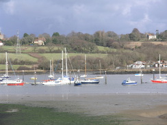
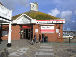
This led me on into the city centre. A ferry was just arriving as I walked into the terminal, so I hung around for a few minutes before boarding. This was my last planned walk on the Isle of Wight, and it had been a pleasant end to a good few days on the island. Now my plans lay on the slightly larger island to the north...
 |
 |
|
Directions
This walk starts off at the junction of High Street and Pier Street in Ventnor at SZ563775. Head southeastwards down Pier Street; it approaches the top of the cliffs and curves to the right, becoming Shore Hill. As it jinks to the right once more turn left down a path that zigzags downhill before ending at the promenade by the harbour.
Once there, climb up the path and return through the streets to the junction where the walk started. Follow the High Street as it curves to the right to head in an easterly direction. Take the first road off to the left, Spring Hill, and follow this as it climbs uphill. Take the first road off to the left, Grove Road, and follow it as it heads initially westwards, before curving to the right before ending at Mitchell Avenue at SZ561778.
From here the route climbs up eastwards onto St Boniface Down; I took a looping route through the little valley to the northeast, but a better route is to turn left along the road for a few yards before turning right up Old Station Road. Follow this as it curves around to the right, and then take a footpath that leads off to the right, squeezing past a wall on the right. Continue along this path as it starts to climbs uphill, soon emerging into some open land.
The path climbs up, initially following a treeline on the right before continuing along the top of the ridge. It eventually reaches a junction in paths near the fence of the radar station on the down at SZ567783. At the junction turn left and follow a track northwestwards, with some grand views off to the left. Follow the track as it curves to the right before ending at the road on St Boniface Down.
Turn right and follow the road east-northeastwards along the top of the down, keeping the fence of the radar station on the right. The track jinks to the right once past the station until a car park is reached at SZ573786. Enter the car park and turn left, crossing an area of rough ground before curving to the left and ending at a better track. Turn right and start following northwards across Luccombe Down.
Continue on for about 0.8 miles; when a stile is reached at about SZ567800, turn right across a stile through the hedge to ascend a hill for a short distance to a trig pillar on Shanklin Down, before returning to the path. This curves to head west-northwestwards, descending slowly down St Martin's Down. Just before a hedge is reached, turn right to head steeply downhill along a path that soon curves to the left, skirting the side and base of an old quarry on the left.
Head on downhill northwestwards until a hedge is reached at SZ559805. Squeeze through the hedge and into some trees; here take either a footpath or a bridleway; I took the footpath that headed westwards before curving southwestwards; initially the going was hard through the trees, but soon it enters a field. Keep the hedge on the right as it continues to descend across fields, before crossing a stile to meet Castle Road. Continue on down Castle Road; as the road forks take the right-hand fork and follow it as it crosses an old railway line on a narrow bridge.
Immediately on the other side of the bridge, turn right to head along a footpath that heads northwards, skirting a factory on the right before descending to meet the old railway line. Continue for a few hundred yards, and when a footpath is reached on the left, turn left and heads down some steps until the B3327 road is reached at SZ549801.
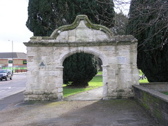
Carefully cross the road and head on westwards along Appuldurcombe Road. As this curves to the right head straight on along a track that heads up towards Appuldurcombe House. After a few yards, turn right to join a bridleway that heads northwestwards across fields, finally joining a track for the last few yards as it approaches an ornate gateway at SZ540807. Go through the smaller gateway on the left-hand side of the large gate to reach a track on the other side.
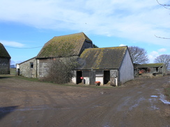
Continue along this track as it heads northwestwards for three-quarters of a mile, descending to reach the A3020 road at SZ532817. Turn left along the main road for a few yards, and then turn right to join another track. Follow this northwards for half a mile until it reaches Moor Farm. Head straight on past the farm buildings, after which the track is rougher.
Follow the track for a little over half a mile, after which it curves to the left to head westwards towards Great Budbridge Manor. The track passes some distance in front of the house, which is off to the left, before curving to the right to meet a track junction at SZ529836. Here turn left and follow a track that heads westwards, with a hedge on the left. On the other side of the hedge are some greenhouses. The track climbs over the slight bank of an old railway line before continuing on; it jinks to the left and then immediately right to continue westwards before ending in a bend in a road at SZ522836.
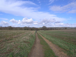
Turn right and follow this road northeastwards for a little over half a mile until the site of Merstone Station is reached. Turn left to join a path that runs along the old railway line; follow this northwestwards for half a mile until a track is reached at SZ520851. Turn left along this track for about a hundred yards, and then turn right along another track. Follow this northwestwards for three-quarters of a mile as it passes Birchmore Farm until a junction with another track is reached at SZ508856. Turn right to follow this track northwards for about fifty yards until it meets the course of the old railway line once more, and then turn left to follow the old railway line north-northwestwards for nearly half a mile. The path skirts to the right of some industrial buildings before the A3020 road is reached in Blackwater.
Carefully cross the main road and continue on along the old railway line as it winds in a rough northerly direction for a little over a mile until it ends at the B3401 road in Shide. Carefully cross the road and then continue on along a narrow path called the Shide Path, initially with a stream on the right. This curves to the left before ending at Medina Avenue. Turn right and follow this road northwards for a quarter of a mile.
When this walk ends at the B3341 road, turn left along the road and then take the first road off to the right, Church Litten. Follow this road northwards for a couple of hundred yards towards the centre of Newport. Cross over the B3323 road, with the bus station to the left, and continue north along Town Lane. When this soon ends, squeeze down a narrow lane ahead to reach the High Street.
Turn left for a few yards and then right down Holyrood Street, heading northwards for a couple of hundred yards to a roundabout. Turn left along River Way to reach another roundabout, then turn right to continue along River Way as it heads under a bridge that carries a dual carriageway overhead. Cross a roundabout on the other side and continue on northwards for a quarter of a mile to another roundabout. Head straight on, and as this curves to the left join a path that runs along an old railway line.
Follow the railway path northwards for three miles until it ends at a road on the southern outskirt of West Cowes at SZ498947. Cross the road and climb up onto the old railway embankment on the other side. Follow this as it squeezes past houses; it soon curves to the left and ends at Tennyson Road. Turn right and follow this road northwards; when it ends at a T-junction, turn left uphill along Smithards Lane to reach the A3020 Newport Road.
turn right and follow the A3020 northward towards the centre of the town; after a while it curves to the right to descend northeastwards towards the sea. As it curves to the right once more, turn left down Birmingham Road. Follow this, and when it ends continue straight on along High Street into the centre of the town. Shortly after the Vectis Tavern on the right, turn right through an archway to reach the West Cowes ferry terminal at SZ496961.
 |
 |
|
Distances
| From | To | Distance (m) | Ascent (ft) | Descent (ft) |
|---|---|---|---|---|
| Ventnor | Wroxham | 5.1 | 1047 | 863 |
| Wroxham | Newport | 8.0 | 269 | 522 |
| Newport | West Cowes | 4.9 | 256 | 282 |
This makes a total distance of 18.0 miles, with 1572 feet of ascent and 1667 feet of descent.
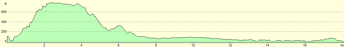
For more information on profiles, ascents and descents, see this page
Transport
Southern Vectis route 1 operates regular services from the ferry terminal in West Cowes to Newport; from there, half-hourly services run on route 3 from Newport to Ventnor.
 |
 |
|
 |
 |
|
 |
 |
|
 |
 |
|
 |
 |
|
 |
 |
|
 |
 |
|
 |
 |
|
 |
 |
|
 |
 |
|
 |
 |
|
 |
 |
|
 |
 |
|
 |
 |
|
 |
 |
|
 |
Disclaimer
Please note that I take no responsibility for anything that may happen when following these directions. If you intend to follow this route, then please use the relevant maps and check the route out before you go out. As always when walking, use common sense and you should be fine.
If you find any information on any of these routes that is inaccurate, or you wish to add anything, then please email me.
All images on this site are © of the author. Any reproduction, retransmissions, or republication of all or part of any document found on this site is expressly prohibited, unless the author has explicitly granted its prior written consent to so reproduce, retransmit, or republish the material. All other rights reserved.
Although this site includes links providing convenient direct access to other Internet sites, I do not endorse, approve, certify or make warranties or representations as to the accuracy of the information on these sites.
And finally, enjoy your walking!
Nearby walks
| # | Title | Walk length (miles) |
|---|---|---|
| 305 | Tipner to Browndown | 18.9 |
| 306 | Browndown to Bursledon | 12.9 |
| 307 | Bursledon to Southampton | 9.2 |
|
|

|