Walk #941: The Monsal Trail from Bakewell
 |
 |
|
General Data
| Date Walked | 17/11/2011 |
| County | Derbyshire |
| Start Location | Bakewell Bridge car park |
| End Location | Bakewell Bridge car park |
| Start time | 08.00 |
| End time | 14.22 |
| Distance | 18.5 miles |
| Description | This walk follows the Monsal Trail along the old railway line west from Bakewell, returning via a couple of diversions around Chee Dale and Water-cum-Jolly Dale. |
| Pack | Today I carried my 30-litre Karrimor rucksack, filled with water, my waterproofs, a book and other odds and ends. |
| Condition | I feel absolutely fine after this walk. |
| Weather | Today was a bright and sunny day, with none of the loq cloud that had dominated the last couple of days. It started off quite cold early on, but it soon warmed up. |
| OS map | Outdoor Leisure number 24 (The Peak District - White Peak Area) |
 |
 |
|
Map of the walk
Maps courtesy of Google Maps. Route for indicative purposes only, and may have been plotted after the walk. Please let me have comments on what you think of this new format. For a detailed table of timings for this walk, please see the table file.
 |
 |
|
Notes
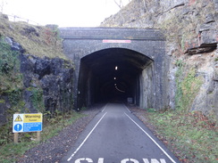
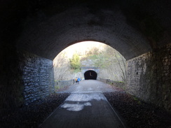
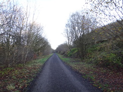
I had only ever planned to do two days' walking on this trip up to Derbyshire, but the forecast for today was good and so I decided to delay my departure until later in the day so that I could do another walk. It seemed sensible to do a short and easy walk so that I would not be tired for the drive home, so I settled on the Monsal Trail, which follows the old railway line between Bakewell and Blackwell Mill near Buxton. I have walked this trail many times before, but earlier this year four tunnels have been reopened to the public. This meant that three diversions into the Wye valley were no longer necessary, and I was keen to experience the new route.
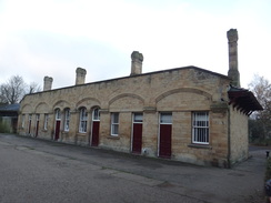
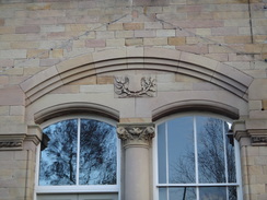
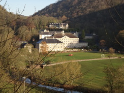
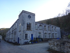
I had the best night's sleep of the trip so far and awoke later than usual. My first task was to disassemble my tent in the dark and pack up my car ready for the half-hour drive to Bakewell. It took me longer than expected due to a wrong turn and I ended up getting to the large car park in the town just before eight. It did not take me long to get my kit together and head up the hill towards the site of Bakewell railway station. This has now been converted into offices, but the wonderful creamy-yellow stone still shone in the sunshine. It was a rather spectacular building for a small market town, the reason being that it was used by the Duke of Rutland whose home, Haddon Hall, lies nearby. Old pictures of the station with its glass canopies intact shows a beautiful station that well befitted a duke.
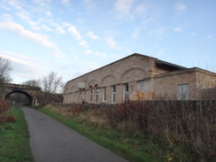
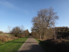
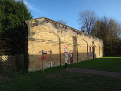
A mile walk along the trail took me to Hassop station, which was similarly grand despite being in the middle of nowhere and a mile from the village after which it was named. The reason was that another Duke, this time the Duke of Devonshire, used the station to reach his stately home at Chatsworth. The dukes could not be expected to share a station and the Midland Railway could not make one station grander than the other. This explains why Hassop's station is so out of scale for its location, especially when compared to other stations on the line. The station building at Hassop is now a cafe, but this was not open at this early hour.
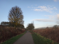
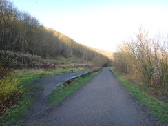
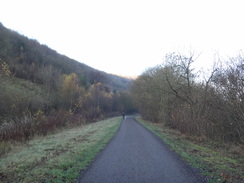
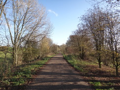
Twenty years ago the path underfoot was gravel, but it had now been surfaced with tarmac. This meant that it was quite hard on my feet, especially as I was wearing my new boots. It passed the site of Great Longstone station, where steps led up to the imposing Thornbridge Hall immediately behind. Again it was a rural station given undeserved prominence by the squirearchy. Soon I came across the point where the trail used to head off into Little Longstone to avoid the Headstones Tunnel.
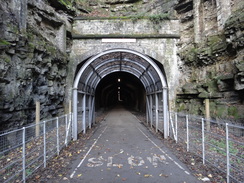
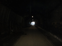
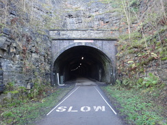
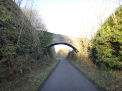
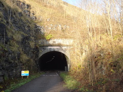
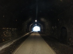
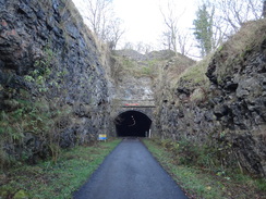
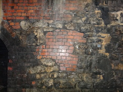
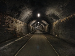
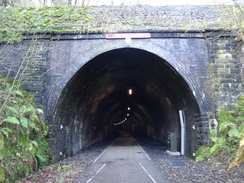
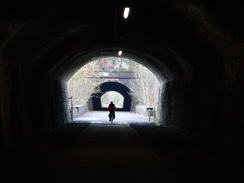
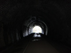
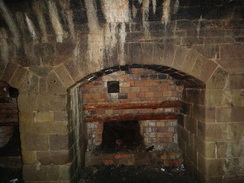
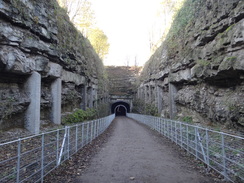
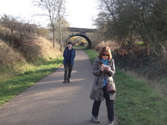
The reopening of the tunnels meant that the trail now continued through a deep cutting towards the tunnel's eastern portal. Lights had been strung from the top of the tunnel's arch giving some illumination, but it was still fairly dark and atmospheric. Thick clumps of soot remained on the brickwork in places and creamy deposits of water-borne lime had covered others. The tunnel itself was of a surprising design - stonework up to head height, then brick to the arch springing, and a brick arch overhead.
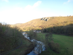
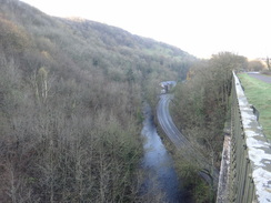
All too soon the tunnel ended and I emerged out onto the Monsal Head viaduct. This is one of the Peak District's more famous views, with a pub sitting on the hillside above and grand views over the River Wye below. It was highly controversial when first constructed and even led John Ruskin to pen a famous ode that claimed:
There was a rocky valley between Buxton and Bakewell, once upon a time, divine as the Vale of Tempe You Enterprised a Railroad through the valley - you blasted its rocks away, heaped thousands of tons of shale into its lovely stream. The valley is gone, and the Gods with it; and now, every fool in Buxton can be in Bakewell in half an hour, and every fool in Bakewell at Buxton; which you think a lucrative process of exchange - you Fools everywhere'.
Ruskin's ire could be understood at the time, but 150 years later the viaduct and embankment have become a much-loved sight. Old black and white pictures shows steam trains bursting out of the tunnel and onto the viaduct with the river far below, and it is a shame that such views are not available now. The railways' loss is undoubtedly the walkers' and cyclists' gain.
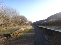
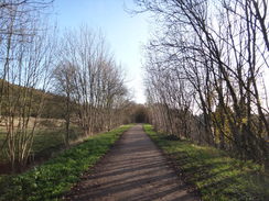
The walk through Headstones Tunnel had been wonderful (I am rather sad when it comes to engineering structures) and soon I was striding along a ledge that Navvies had cut into the hillside to reach the next tunnel. First the trail passed the site of Monsal Dale station. Only one platform was visible on the left and this was unusually low compared to those at other stations on the line. The Midland Railway originally had such low platforms, but over time they were rebuilt at a high level. However this station closed before it was rebuilt, meaning that the platform remained low. The platform on the other side was built out of wooden trestles that were cantilevered over the valley's side; this was removed when the line closed, although the rotted remains of the posts can still be seen.
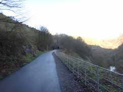
Another two tunnels - Cressbrook and Litton - followed in quick succession, and between the two the trackbed emerges onto a platform over the valley. I had seen this from below many times and was looking forward to seeing the view from it. Sadly this was not as spectacular as I had hoped, although it was impossible not to be impressed with the engineering. This stretch of line cost the Midland Railway a fortune to build and it is easy to see why; the trackbed is either on a ledge cut out of the hillside or in tunnels.
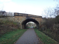
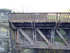
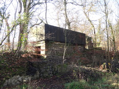
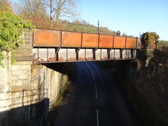
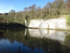
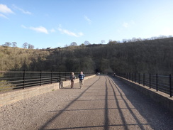
A short distance on the path crossed the Wye once more on one of two side-by-side viaducts to reach Miller's Dale station, once the busiest on the line. The path crossed the original 1863-built viaduct; the one next door was built in 1905 to increase capacity. Now the original viaduct is in the best condition and the later one is sadly closed off to walkers. One of the few remaining station buildings is now a visitor's centre, next to which is a large car park. Trees have covered much of the rest of the area, including a nearby limestone quarry that is slowly being recaptured by nature.
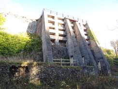
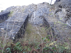
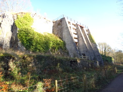
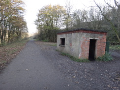
Massive concrete buttresses mark an old lime kiln, one of which can be entered. This was used by the adjacent quarry and was rail-connected; good views can be had from a spur path that climbs up to the top. Some children were carrying a plastic bucket filled with helmets; others in front of them wore harnesses ready to abseil off a viaduct. They were lined up ready to go off, and a quick glance down made me thankful that they were doing it rather than me. Immediately afterwards there were three tunnels - Chee Tor, Chee Tor No. 1 and Rusher Cutting. The latter of these was of particular interest as you can walk around the side to see the massive brick abutments that hold the tunnel up. Care needs taking because there is a dramatic drop off to the right, but the side of the tunnel is well worth a look for an engineering geek such as myself.
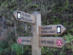
A couple more viaducts took me to Blackwell Mill, where the trail ends. Signs for the Pennine Bridleway showed where this new trail joins the Monsal Trail for a short distance, and which I will hopefully be walking next year. The trail here runs along the southern side of a triangular railway junction, with the western curve still in use for the freight trains that carry trains filled wtih limestone. Down below, in the middle of the triangular, are a few cottages at Blackwell Mill. These are so secluded that the houses had their own small railway halt; the platform was only one coach long and was reputedly the smallest station on the British Rail network.
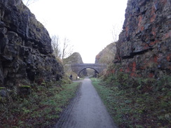
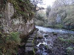
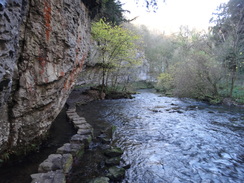
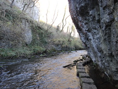
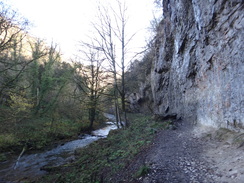
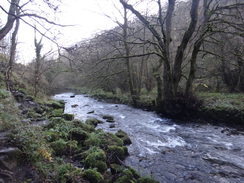
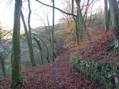
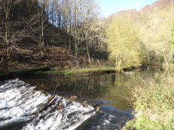
My parents phoned and told me that they were on their way to Bakewell; I therefore decided not to nip down to visit the cottages and instead headed back eastwards across the viaducts and through the tunnels. Before the main Chee Tor tunnel, however, I diverted off the old railway so that I could visit one of my favourite stretches of path in the UK. Before the Chee Tor tunnel opened earlier in the year the path along Chee Dale carried the Monsal Trail. The dale is very narrow with limestone cliffs towering over the Wye below. It is a magical place, especially at a spot where stepping stones take you upstream with the cliffs above.
In fact it is one my favourite places in the world, and it is little visited despite being one of the most spectacular dales in the Peak District. The tourist honeypot of Dovedale has nothing on it. Partly this is because it is not easy to reach, with the path sometimes being impassable due to flooding, and partly because the path through it is rugged. It has been eleven long years since I was last there and so with joyous heart I descended the path and crossed the stepping stones. The river level was low and they were easy to cross, but some steps carved out of the cliff face were very slippery.
It is much more deserving of Ruskin's praise than Monsal Dale, yet I found myself sadly uninspired on this visit. My memories are of gloriously sunny skies and green grass; of lying beside the burbling waters of the river with my lover in my arms. Although the sky today was sunny, it was too low in the sky to land on the grass, which was lank and damp. The area around Wormhill Springs was a gloomy, muddy morass that lacked the sparkling magic of my memories. There is only one thing for it: I will have to return here one hot, dry summer and lie on the grass with my wife in my arms.
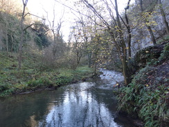
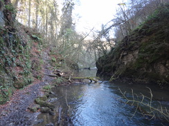
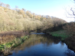
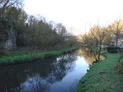
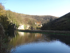
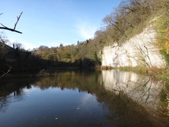
I returned to the Monsal Trail and headed east through Miller's Dale station towards the Litton and Cressbrook tunnels. Here I diverted off the Monsal Trail once more to once again follow the old route before the tunnels reopened. This took me down past the massive mill buildings at Litton, now converted into very tidy flats, and through a curving valley with the strange name of Water-cum-Jolly Dale. This follows the Wye and is once again a superb walk, especially near Cressbrook where it passes underneath a white wall of limestone that reflects in a large pool of water.
I decided not to do the final diversion around Monsal Head tunnel due to time - my parents would be waiting for me in Bakewell, and I wanted to see them. Instead I headed through the tunnel, enjoying the experience of being within its dark, cool confines. My mobile phone rang whilst I was in the middle - surprisingly I had strong reception within it. My parents were now at Bakewell and were starting to walk towards me. Happy that I had made the right decision I headed on into the light.
Return journeys always seem to take less time than outward ones, and I was soon approaching Hassop. A dog chased a red ball towards me and I kicked it back towards the dog's owners, only for a cyclists coming hard from behind to brake suddenly and fall off. We helped him up and thankfully he was unhurt, but he firstly castigated me for not looking where I was going and the dog owner for letting it run loose. I felt guilty but also annoyed at his attitude - he had been cycling fast from behind and did not even have a bell on his bike to warn other users. The Monsal Trail is a multi-use trail and he should have been prepared to stop as he passed me from behind.
This was still churning around in my mind as I passed Hassop station - the cafe that had been firmly shut earlier was now bustling and I kept a sharp eye out for my parents - my mum is rather partial to cafes. They were not visible and so I walked on towards Bakewell. Soon a couple of reprobates became visible ahead and I recognised my parents. We chatted as we walked back towards Bakewell and the remaining mile flew past; was had lots to chat about and before I knew it we were heading down the hill into the town. Our first task was to find a cafe, and I set off for home about an hour later. The trip had been slightly spoilt by the weather, but the three days of walking had been enjoyable nonetheless.
 |
 |
|
Directions
This walk starts off from the Bakewell Bridge car park in Bakewell at SK220686. Leave the car park and cross Coombs Road to reach Station Road. Turn right to follow the road uphill as it curves to the left; there are pavements on both sides of the road. The gradient flattens and it curves to the left once again, passing a company car park and the old Bakewell station building to the right. After the station building turn right across the far edge of a public car park and pass the gable end of the building to reach the Monsal Trail at SK222691.
From here it is simply a case of turning left and following the Monsal Trail northwestwards for a little over eight miles. On the way it passes the following features:
- Hassop station - 1 mile
- Great Longstone station - 2.2 miles
- HeadstonesTunnel - 3.1 miles
- Cressbrook Tunnel - 4.2 miles
- Litton Tunnel - 4.6 miles
- Miller's Dale station - 6.3 miles
- Chee Tor Tunnel - 7.0 miles
- Chee Tor No. 1 Tunnel - 7.2 miles
- Rusher Cutting Tunnel - 7.5 miles
- End of trail (Blackwell Mill / Chee Dale) - 8.1 miles
The return journey was more complex as I took two diversionary paths - the first around Chee Tor and the second around the combined Litton and Cressbrook tunnels. From the western end of the trail at Blackwell Mill, head east along the trail for a mile until just before the western portal of Chee Tor tunnel is reached. Cross the viaduct in front of the tunnel and then turn right through a gap in a stone wall to join a path that descends steps down the steep valley side. Soon a T-junction with another path is reached; turn right to head down some more steps that head under the railway viaduct to reach a footbridge over the River Wye.
Cross the footbridge, and on the other side turn right to follow a path with the river on the right. This path soon reaches a set of stepping stones that lie along the river, actually under the cliff in places. This stretch of path can be utterly impassable after bad weather so care needs taking, but in dry weather it can be a superb stroll. At the end of the stones a boardwalk continues on across a boggy area of ground as high cliffs rise up on the other side of the river.
The path climbs steps up the hillside to continue high above the river before descending to cross a plank footbridge over a stream at Wormhill Springs. Cross this and turn right across a tumbledown stone wall, still following the river on the right. It crosses another plank footbridge and climbs up steps once more above the river, shortly after this the path becomes flatter and easier. A short stretch of boardwalk interrupts the path as a footbridge over the river becomes visible ahead at SK127734.
Here you have two choice; you can cross the footbridge and turn half-left to head uphill along a grassy slope; this is quite a contrast to the rigours of the earlier path. At the end of the field squeeze past a field gate and continue on uphill, then take a pedestrian gate beside a second field gate to reach the western end of a railway viaduct at SK130733. The second option is not to cross the footbridge over the river and instead continue on along the northern bank of the river; it curves to the right and a fifth of a mile after the footbridge it passes under the railway viaduct. Climb some steps just before the viaduct to reach the old trackbed at the eastern end of the viaduct.
From the viaduct, turn left to start following the old railway line eastwards for 1.8 miles. It passes through Miller's Dale station and approaches the western end of Litton tunnel. Well before the tunnel portal is reached, turn left at SK158729 to join a path. This path slopes downhill and hairpins to the left to descend steps to reach a footbridge over the river. Cross this and follow a path that leads out onto a road in Litton. Turn right to follow the road eastwards, passing through a gateway and between the mill buildings, which have now been converted into houses.
The track passes the main mill building on the right and then curves to the right to cross a mill leat. On the other side it curves to the left; pass a field gate and head on with the river on the right. Follow this path for a mile as it accompanies the river in two big loops, eventually passing under a sheer limestone cliff to the left before reaching a wooden footbridge at Cressbrook at SK172728. Note this concessionary riverside path can flood after heavy rain. Cross the footbridge, and on the other side the path curves to the right, keeping a wall on the left to reach a footbridge across a weir on the Wye on the left. On the other side of the bridge turn right to head up a sloping path with some steps. The path hairpins to the left and continues slowly climbing to the south. After a quarter of a mile it climbs a couple of steps to reach a pedestrian gate that reaches the old railway line by the western mouth of Cressbrook Tunnel at SK172723.
Turn left to start following the old railway line southeastwards for four miles until Bakewell station is reached at SK222690. Just before the old station building is reached turn right to pass the gable wall of the building to reach a public car park. Walk through this to reach a public road. Turn left along this and follow it as it curves to the right to join the B6048 road and heads downhill; there are pavements on both side of the road. Just before the B6048 road ends at the A619, turn left across Coombs Road to reach the Bakewell Bridge car park, where this walk started and now ends.
 |
 |
|
Distances
| From | To | Distance (m) | Ascent (ft) | Descent (ft) |
|---|---|---|---|---|
| Bakewell | End of trail in Chee Dale | 8.7 | 370 | 30 |
| End of trail in Chee Dale | Bakewell | 9.8 | 800 | 1140 |
This makes a total distance of 18.5 miles, with 1170 feet of ascent and 1170 feet of descent.
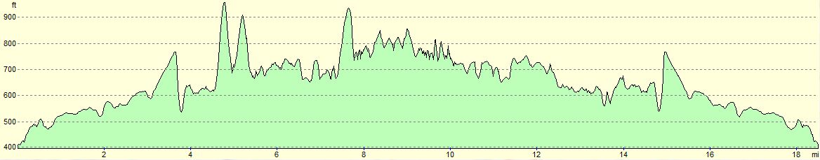
For more information on profiles, ascents and descents, see this page
 |
 |
|
 |
 |
|
 |
 |
|
 |
 |
|
 |
 |
|
 |
 |
|
 |
 |
|
 |
 |
|
 |
 |
|
 |
 |
|
 |
 |
|
 |
 |
|
 |
 |
|
 |
 |
|
 |
 |
|
 |
|
|
 |
 |
|
 |
 |
|
 |
 |
|
 |
 |
|
 |
 |
|
 |
 |
|
 |
 |
|
 |
 |
|
 |
 |
|
 |
 |
|
 |
Disclaimer
Please note that I take no responsibility for anything that may happen when following these directions. If you intend to follow this route, then please use the relevant maps and check the route out before you go out. As always when walking, use common sense and you should be fine.
If you find any information on any of these routes that is inaccurate, or you wish to add anything, then please email me.
All images on this site are © of the author. Any reproduction, retransmissions, or republication of all or part of any document found on this site is expressly prohibited, unless the author has explicitly granted its prior written consent to so reproduce, retransmit, or republish the material. All other rights reserved.
Although this site includes links providing convenient direct access to other Internet sites, I do not endorse, approve, certify or make warranties or representations as to the accuracy of the information on these sites.
And finally, enjoy your walking!
Nearby walks
| # | Title | Walk length (miles) |
|---|---|---|
| 11 | Stanton Moor | 2.9 |
| 12 | Darley Dale, Stanton Moor and Rowsley | 8.7 |
| 14 | Friden, Long Dale and Gratton Dale | 7.8 |
|
|

|