Walk #959: Cleveland Way: Helmsley to Oakdale Upper Reservoir
 |
 |
|
General Data
| Date Walked | 05/09/2012 |
| County | North Yorkshire |
| Start Location | Helmsley |
| End Location | Oakdale Upper Reservoir |
| Start time | 11.10 |
| End time | 19.23 |
| Distance | 21.0 miles |
| Description | This walk has two varied main sections: a wealk west from Helmsley to Sutton Bank generally crosses farmland or forestry via Rievaulx. This is followed by a long walk north along the western escarpment of the North Yorkshire Moors. It ends about a mile and a half away from the village of Ostmotherley. |
| Pack | Today I carried my Macpac Glissade rucksack containing my North Face Westwind tent, spare clothes, waterproofs, water, and enough food for three days. In total it weighed about thirty-five pounds. |
| Condition | I feel absolutely fine after this walk. |
| Weather | The day's walking started off sunny and reasonably warm. As the day progressed the clouds gathered, although there were still some welcome sunny periods interspersed. |
| OS map | Landranger number 100 (Malton & Pickering, Helmsley & Easingwold) |
 |
 |
|
Map of the walk
Maps courtesy of Google Maps. Route for indicative purposes only, and may have been plotted after the walk. Please let me have comments on what you think of this new format. For a detailed table of timings for this walk, please see the table file.
 |
 |
|
Notes
I now only have three National Trails to complete before I have the full set, and it seemed to be a good idea to get one done before autumn. The Southern Upland Way was too long to fit in the available time, and so I decided to do the Cleveland Way instead. This trail has two halves: an inland starts from Helmsley and loops around the western and northern edges of the North Yorkshire Moors. The second half is coastal, heading south along the cliffs from Saltburn to Filey, passing through Whitby and Scarborough on the way. I had done the coastal half before, and was very much looking forward to doing it again.
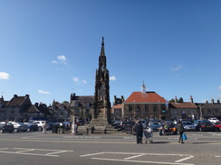
Sencan dropped me off at St Neots station in time to get an early train, and after two changes and a bus I arrived at Helmsley just after eleven. I took a few photos of the buildings surrounding the beautiful market square and the ruined castle keep before setting off. No sooner had I done so than I realised that my dictaphone's batteries were flat. I headed back to the town square and queued in a shop for some batteries. There was a cashpoint next door, so I got some cash out and also three sausage rolls from a bakers before belatedly setting off once again. This was all too much faffing and, aware that I was short of time, I strode purposefully away from the square with my heavy load.
I had previously walked the first few miles of the Cleveland Way as part of a circular walk, and I remembered the route well. A carved stone seat beside a car park marked the official trailhead, and soon a track was heading uphill. For some reason the trail does not go past the castle's keep and instead heads slightly to the north. This meant that the only views of the keep were from a distance, either from the market square in Helmsley or from the top of the first climb. Neither of these views are particularly good, and it would have been easy for a slightly more sympathetic route to have been found.
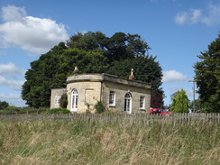
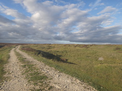
The trail soon skirts some woodland before it negotiates a dry valley - the first steep climb on the trail, and a warning of what was to come. My pack felt overly heavy and I was pressured for time - the late start meant that it was going to be hard for me to reach the campsite in Osmotherley in time. As there was still a chance of getting there before dark I pressed myself. After passing an attractive lodge building on the hillside the trail followed a track downhill to meet a road; a path had been constructed just off the road, an indication that this trail was mature and well-tended. Indeed, the Cleveland Way was the second National Trail opened, the first walkers following the route over forty years ago.
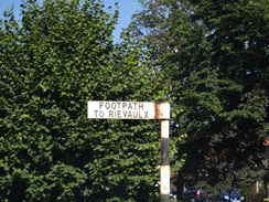
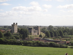
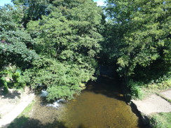
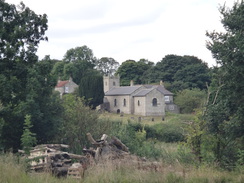
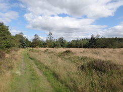
The trail followed the road as it crossed the River Rye at Rievaulx Bridge, with the magnificent ruins of Rievaulx Abbey out of view to the north. The trail eschews the ruins and instead continues along the road when a diversion to them would have been both easy and rewarding. Soon a track led on past a series of little ponds before starting a long but generally easy climb to the little hamlet of Cold Kirby. A harsh descent and ascent into a small valley led close to the church, and all too soon the trail left the village.
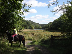
I knew there was a pub, campsite and B&B at Hambleton on the main road, and that the pub closed at 14.30. It seemed like a good place to stop, so I pressed on across some rather uninspiring scenery to reach the Hambleton Inn in plenty of time. It was quite warm, and instead of sitting indoors I went outside to sit on a bench in the sun. A couple joined me on the next-door table for a few minutes, and we chatted as they skulled down their drinks and set off.
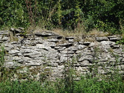
The next stretch of trail joined the busy main road for a short distance before angling away alongside the Casten Dike, a late Bronze Age or Iron Age dyke. This was scarcely visible through the bracken on the right and the ditch and bank were scarcely worthy of the name, although I did manage to get at least one decent photo.
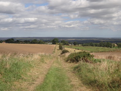
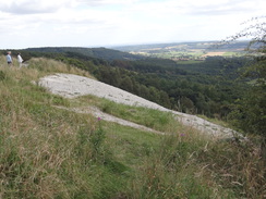
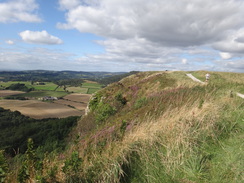
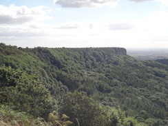
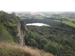
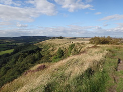
The trail soon reached the edge at Sutton Bank, where superb views unfolded south and north along the escarpment. A string of traffic was tolling their way along the main road which clambers its way uphill in one long and ponderous zig-zag. Here I had a choice to make: my target for the day was to the north, but the trail makes an official diversion south to visit the Kilburn White Horse. This is the largest white horse in terms of surface area in Britain, and was first cut out of the hillside in 1857. I considered not making the diversion for a few moments and then somewhat reluctantly set off south.
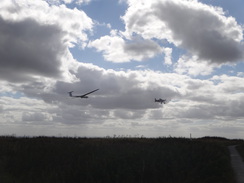
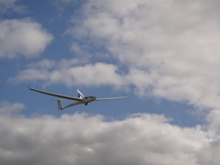
It was a far better stroll than I was expecting. The views in both directions along the escarpment edge were superb in the sunshine, and a small plane was towing gliders into the air from a gliding club on the top of the hillside to the left. There was plenty to see, especially when the path approached the top of the white horse where an expanse of white limestone chippings stretched down the hillside. Here the trail headed off through undergrowth to a minor road that headed down the hillside, but I climbed up to follow a good path that led to a car park that had a good view of the gliding club's observation tower. It is a shame that the trail does not get a better view of the white horse from below, but I did not mind missing the extra climb that would have been needed.
The return journey was equally entertaining. Gliders were being towed into the sky, an exception being one whose propeller was frantically turning above the fuselage. Soon I was passing the end of the Casten Dike and headed off across new territory towards the visitor's centre at Sutton Bank. Since it was the last chance to stop before Osmotherley, I diverted off the trail to use its facilities. A kind lady at the information desk filled my water bottles, and I jammed both bottles of these into my rucksack's rear pocket.
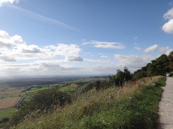
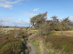
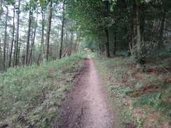
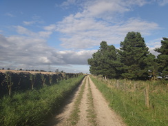
My pack was now four pounds heavier, but the load did not feel too bad as a good path took me north along the escarpment's edge. There were few serious ascents to trouble me and the views were routinely good until the road at Sneck Yate was reached. The trail crossed the road and then plunged into woodland, before climbing sharply to pass High Paradise Farm. Shortly beyond this the trail joined Hambleton Drove Road, a rough and scenic track that crosses the moors.
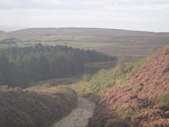
By now I was considering what to do for the night. I had walked the minimum distance I had wanted for the day, but still felt fit enough to continue on. After skirting the edge of some woodland the trail continued across moorland; the heather still displayed a haze of faded purple and the sunny skies made me feel particularly good. However I was having trouble sucking water through the pipe from my Platypus bladder and each strong suck only delivered a tint dribble of water. It was only enough to wet my tongue and did not quench my thirst.
It was still just about possible to reach the campsite in Osmotherley before dark and so I decided not to stop to sort the problem out. A few cyclists passed as the track gently climbed onto Arden Great Moor. I was feeling fairly euphoric, although worries about time kept me striding on to reach Whte Gill Head, where the trail turns from a northerly to northwesterly course over Black Hambleton.
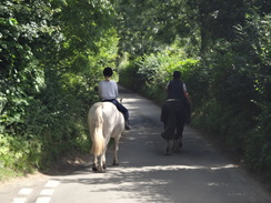
I stopped to check my map as two women approached from behind, pushing their road bikes along the stony track. We chatted for a couple of minutes and they kindly straightened a kink out of my water tube, allowing me to take large gulps of water. They were cycling from York to Alnwick over a few days, and were heading towards Osmotherley youth hostel for the night. However the track's rocky terrain was largely impassable for their road bikes, and they were having to push them across long stretches of boulders. We walked together across the moor for five minutes before they came across a smoother section and remounted their bikes.
I walked alone as another cyclist on a mountain bike passed and sped off down the slope. He soon overtook the two ladies who were still clearly visible ahead and had climbed off their bikes once more. And no wonder: the descent off Black Hambleton was quite steep and rocky, forcing me to take my time on tired legs. I had not bothered using my walking poles today, and this was the first time that they would have proved useful.
Fortunately the gradient soon slackened. Reaching Osmotherley before dark was now firmly out of the question and I started looking for somewhere to camp for the night. One spot looked ideal; it was far enough away from the road for me to remain hidden and flat enough for me to erect the tent. I sat down on the grass for a few seconds but soon a plague of insects were swarming around me. Since I still had a little time left I shrugged my pack onto my shoulders and continued along the track, looking for a better spot.
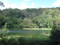
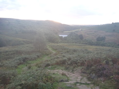
Hambleton Drove ends at a bend in a public road, where the trail turns off to continue the descent down to Osmotherly. Another likely camping spot also proved to be insect-ridden and as the sun sank lower I descended further. The path crossed a stream before reaching the Oakdale Upper Reservoir. Water levels were low in the reservoir and large expanses of gloopy mud stretched from the banks. Nearby, a reasonable camping spot appeared right beside the track. It was not perfect, but the decreasing light told me I did not have long to find a spot. I sat down for a few minutes and when no insects appeared, set up my tent and crawled inside.
A runner said hello as he sped past, and a couple did not pay me a moment's attention as they strolled hand-in-hand. The late start of the walk from Helmsley and my heavy load meant that I had not reached the campsite in Osmotherley, but I had gone further than I expected. The last few miles walked today meant that it will be possible for me to walk to Kildale tomorrow over the remotest stretch of the trail.
 |
 |
|
Directions
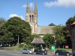
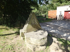
This walk starts off at the monument in the market place in Helmsley at SE612837. Head west through the market place (now mainly a car park) and follow a narrow road that passes between the Royal Oak on the left and the Town Hall on the right. Immediately after the buildings the road crosses a bridge over a stream and ends at a T-junction with Castlegate. Turn right up this road and follow it northwestwards, passing the Helmsley church on the right. Shortly after the church, turn left up a road called Cleveland Way. This passes buildings on the right to reach a long-stay car park on the left, where there is also a toilet block. A simple stone seat on the right at SE609838 marks the start of the Cleveland Way.
Pass the car park and continue westwards uphill along a track. As the track forks, take the right hand branch to continue uphill. The track ends at a clapper gate beside a field gate; go through this into a field and follow a hedge on the left. Go through a second clappergate / field gate combination and continue following the hedge on the left. At the corner of this field go through a clapper gate and turn left to follow an obvious path with a hedge on the left. This heads straight downhill towards some woodland ahead.
The path does not enter the trees, and instead turns right to head westwards with a broken-down wall and a steep tree-lined slope to the left. It passes a couple of fields on the right; at the end of the second the path enters the trees and descends steeply down steps before climbing up steps on the other side. At the top the path emerges from the trees into another field. It follows the edge of the trees on the left; when the trees end the path skirts a stone wall on the right and curves slightly to the left to cross an unsurfaced track near Griff Lodge at SE590834.
Cross the track and on the other side follow a good path that heads westwards. This passes an area of woodland on the left before entering the trees and curving to the right to take a more northwesterly course, descending to reach a road. Turn left to follow this road as it curves sharply to the right; there is an off-road footpath on the left that allows you to safely negotiate the bend. When this path ends, join the road and follow it westwards until it reaches Rievaulx Bridge over the River Rye at SE574842.
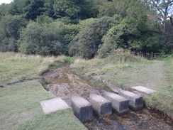
Continue along the road; when another road comes in from the right after a quarter of a mile head straight on. After nearly another half a mile the road curves to the left; shortly after the bend turn right down a track that soon reaches a bridleway gate beside a field gate. Go through this and continue along the track as it swings to the left to take a westerly course, passing a series of ponds on the right. Just before a gate is reached, turn right across grass for a few yards to reach some stepping stones over a stream. On the other side go through a bridleway gate and turn left to join a track that immediately ends at a bend in a larger track.
Follow this good track westwards. After a quarter of a mile the track curves to the right; here turn left along another track that heads southwestwards along the grassy bottom of a valley. After a third of a mile turn right off the track and take a footpath that heads steeply uphill. Initially this is along a gap in the trees, but soon the trees enclose the path. It becomes a rocky sunken lane; cross a stile to the right of a field gate and continue uphill as the path emerges into a field. Continue straight on, following a fence on the left. In the corner of the field cross a stile beside a field gate and continue along a track. This slowly climbs, following a fence and then a hedge on the left.
The track becomes the unsurfaced Low Field Lane. Three-quarters of a mile after leaving the trees the track passes two barns on the right and then curves to the left. On this bend, turn right down a footpath that curves to the right as it falls steeply. At the bottom turn left along a vague track that climbs uphill with Cold Kirby church away to the left; the gradient slackens and it joins a road in the hamlet of Cold Kirby. Turn right and follow this road westwards for a few yards until it reaches a junction with another road at SE532845.
Follow the road westwards through the village; just beyond the last house on the last house after 200 yards turn left through a gate to head south down a track; after a couple of hundred yards the track curves to the right to head southwestwards for nearly a third of a mile. It drops down into a little dip before rising and curving sharply to the left to head south. After a few yards go through a clapper gate and continue on with a fence on the left and a field to the right. It goes through a second clapper gate and continues across rough scrubland towards an area of woodland ahead.
Once at the woodland, the path goes through a gap in a wall and turns to the right to follow the woodland's northern edge westwards. When the trees end go through a bridleway gate, cross a track and follow a grassy path that runs between fences, with Hambleton House off to the right. The path curves slightly to the left before reaching a second bridleway gate. Go through this to reach a surfaced track. Turn left and follow this track as it heads south; it descends a little dip before climbing steeply up the other side to reach the A170 road at SE524830, with the Hambleton Inn on the right.
Turn right to follow the A170 westwards, passing the inn on the right. Carefully cross over to the left-hand side of the road and follow the verge. When a road comes in from the left, turn left for a few yards and then right along a path that enters scrub woodland. The path follows the small ditch and bank of Casten Dike on the right for a third of a mile before it ends at a T-junction with a gravel path at SE517825, at the top of the Sutton Bank escarpment.
Here the main route heads north, but an official diversion heads south towards the Kilburn White Horse. It is easy to follow as it heads in a rough southerly direction above Roulston Scar. After three-quarters of a mile it curves to the left to head in a more easterly direction to reach the top of the Kilburn White Horse figure. Shortly afterwards the path forks; the official route takes the smaller right-hand branch. When this soon reaches some steps leading downhill to the right, head straight on along a vague path that descends to meet a minor road at SE516812. The upper left-hand path is in my opinion better; it curves uphill and crosses a footbridge before zigzagging to reach the road beside a car park at SE516814.
Whichever branch you took, return to the end of the Casten Dike at SE517825. Continue northwestwards along the obvious path; when it forks after a quarter of a mile, follow the right-hand branch for a short distance until it reaches the A170 once more. Carefully cross the road and take an obvious path on the other side that leads towards a car park belonging to a visitor centre. After a few yards and before the car park is reached, turn left across grass to head west. The path crosses a minor road before rejoining the escarpment edge.
Continue following the escarpment northwestwards. Initially the path is broad and easy to follow as it heads through trees, but it soon descends some steps and becomes rough in nature, although still easy to follow. The path emerges from the trees and curves to take a more northerly course to reach a viewpoint at SE506838. Here the path curves sharply to the right to head northeastwards before gently curving to the left to head north beside Hambleton Down. The path gently climbs to reach the low earth bank of an old hill fort; from here the going is relatively level and easy.
At SE507861 go through a bridleway gate in a stone wall and follow the stone wall on the left. After a short distance the wall and path curve to the right to reach another bridleway gate through the wall on the left. Follow a fence on the right towards High Barn. Pass to the left of the barn and continue along the path for another half-mile; cross a stile beside a field gate and continue for a few yards as it descends to reach a road at Sneck Yate at SE507875.
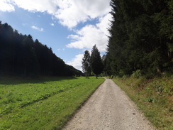
Carefully cross the road and start following a track that slowly descends through an area of woodland. The track initially climbs before cresting a summit and starting to fall. The track goes through a field gate to emerge from the trees into a field at SE505880. Cross an open area to reach another field gate that leads onto a surfaced track, with a small farm downhill to the left. Turn right to follow this track steeply uphill through trees. The climb is short but steep; ignore a forest track that leads off to the left. Go through a bridleway gate beside a field gate and head on towards High Paradise Farm.
Pass the farm buildings on the right; as the track curves to the right, turn left to continue straight on to another brideway gate beside a field gate. Go through this and continue along an unsurfaced track, following a stone wall on the left. Another gate leads to a T-junction with a track called Hambleton Drove Road at SE504889.
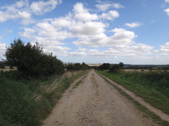
Turn left to start following the drove northwestwards. After a third of a mile it goes through a gate and enters an area of woodland; it skirts just inside the edge of the trees, and after a little over another half-mile it emerges through a gate out of the trees at Steeple Cross. Continue along the track as it slowly curves to take a northerly course across moorland, roughly following a stone wall on the left. A mile after leaving the trees, it passes the end of a public road on the left at SE489915.
Continue along the track as it passes a series of lumps and bumps on the right that mark the site of an old quarry. The track climbs gently for another mile, passing through a gate at SE490922 before reaching a cattle grid above White Gill Head at SE490931. Here the track curves to the left at the head of a small valley to take a more northwesterly course; when the track immediately curves to the right, head straight on along a rougher track. This is an easy walk that gently climbs for a mile to reach Hambleton Head. Almost immediately the track fall steeply northwards; this piece of track is perhaps the most difficult of this stretch of trail. It parallels some woodland on the left and the gradient slackens as the trees end. The track goes through a pedestrian gate beside a field gate and continues on to reach a sharp bend in a road at SE479959, with a small car park to the right.
At the road, turn immediately left down another footpath, part of which runs along flagstones. The gradient steepens as it descends; after a quarter of a mile the track curves to the right through a semi-wooded area to reach a footbridge over a stream. On the other side of the footbridge the track curves to the left; this day's walk ends on this bend at SE474961.
 |
 |
|
Distances
| From | To | Distance (m) | Ascent (ft) | Descent (ft) |
|---|---|---|---|---|
| Helmsley | Kilburn White Horse | 9.1 | 1637 | 909 |
| Kilburn White Horse | Sneck Yate Bank | 5.3 | 942 | 935 |
| Sneck Yate Bank | Oak Dale Upper Reservoir | 6.6 | 709 | 1020 |
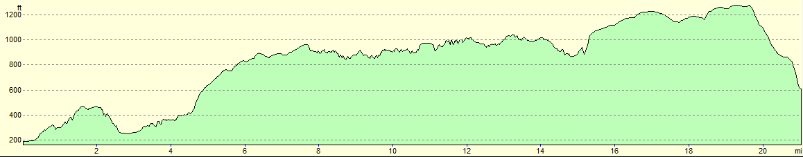
This makes a total distance of 21.0 miles, with 3288 feet of ascent and 2864 feet of descent.
For more information on profiles, ascents and descents, see this page
Accommodation
I spent the night sleeping in my tent beside the track at the northern end of Oak Dale Upper Reservoir.
 |
 |
|
 |
 |
|
 |
 |
|
 |
 |
|
 |
 |
|
 |
 |
|
 |
 |
|
 |
 |
|
 |
 |
|
 |
 |
|
 |
 |
|
 |
 |
|
 |
 |
|
 |
 |
|
 |
Disclaimer
Please note that I take no responsibility for anything that may happen when following these directions. If you intend to follow this route, then please use the relevant maps and check the route out before you go out. As always when walking, use common sense and you should be fine.
If you find any information on any of these routes that is inaccurate, or you wish to add anything, then please email me.
All images on this site are © of the author. Any reproduction, retransmissions, or republication of all or part of any document found on this site is expressly prohibited, unless the author has explicitly granted its prior written consent to so reproduce, retransmit, or republish the material. All other rights reserved.
Although this site includes links providing convenient direct access to other Internet sites, I do not endorse, approve, certify or make warranties or representations as to the accuracy of the information on these sites.
And finally, enjoy your walking!
Nearby walks
| # | Title | Walk length (miles) |
|---|---|---|
| 714 | A circular walk from Helmsey to Rievaulx Moor | 20.2 |
|
|

|