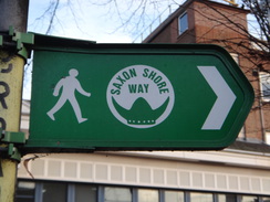
Walk #970: Saxon Shore Way: Gravesend to Hoo Flats
 |
 |
|
General Data
| Date Walked | 08/01/2013 |
| County | Kent |
| Start Location | Gravesend station |
| End Location | Hoo Flats |
| Start time | 07.59 |
| End time | 15.30 |
| Distance | 16.1 miles |
| Description | This was an enjoyable stroll along the Saxon Shore Way east from Gravesend; initially following the Thames Estuary before crossing the Hoo Peninsula and descending down to the banks of the Medway. |
| Pack | Today I carried my Macpac Glissade rucksack containing my North Face Westwind tent, spare clothes, waterproofs, water, and enough food for two days. In total it weighed about thirty-five pounds. |
| Condition | I feel rather tired after this walk, but have no problems to report. |
| Weather | Today's weather was sunny and unseasonably warm at about eleven degrees. It was a great day for a walk. |
| OS map | Landranger number 177 (East London, Billericay & Gravesend) and Landranger number 178 (Thames Estuary, Rochester & Southend-on-Sea) |
 |
 |
|
Map of the walk
Maps courtesy of Google Maps. Route for indicative purposes only, and may have been plotted after the walk. Please let me have comments on what you think of this new format. For a detailed table of timings for this walk, please see the table file.
 |
 |
|
Notes
I had not done a camp in January for many years, and the recent warm weather seemed like an ideal opportunity to put Westie in my rucksack and go camping. One of my plans for this year is to do the Saxon Shore Way in Kent. I had walked parts of the trail on a couple of occasions before, and had quite enjoyed it. It was also fairly flat, something important when I want to get some distance under my belt during the short winter days.
Sadly I could not set off when I wanted due to other commitments, and I could only start as the unseasonably warm weather was about to end. Sencan dropped me off at St Neots station before six, and soon I was at Kings Cross. Here came the first surprise of the trip: I was used to travelling to Kent from the terminals south of the Thames; however all I had to do now was change to St Pancras International where a Javelin train would take me speedily to Gravesend. St Pancras has changed utterly since I used to travel from it to Derby in the 1990s, and the change has massively improved the place without losing any of its character.
Thanks to the spotlessly clean train, I arrived in Gravesend just as it was getting light, and left the station before taking my pack off to arrange everything just how I like it. After a panic in which I thought my wallet was missing, I found it buried deep within my pack. Soon I was heading through Gravesend and had a second task: to fill my water bottles. A bakery provided me with a couple of litres and I stopped to fill my Platypus and change my gaiters, which rather stupidly I had put on the wrong feet.
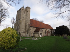
The trail took me towards a church, where a statue of Pocahontas stares forlornly into the distance. The famous Indian women is buried in the churchs graveyard, an unexpected place for a North American Indian lady to have ended up. A short stroll took me down to the Thames Estuary, near to the terminal for the ferry across the river to Tilbury. I diverted off the trail to take a quick look at the river, before returning and passing the foundations of a bunker and then the New Tavern Fort, an eighteenth-Century fort that was built to protect the Thames. This was one of three forts of various eras I would pass in the next few hours.
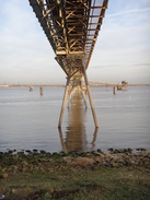
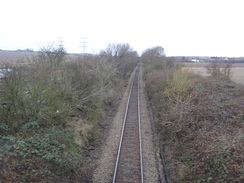
A little swing bridge led over the entrance to a marina, near which was the entrance of the Thames and Medway Canal, a waterway that was built to bypass the estuarine route past the Isle of Grain, which was liable to interception by French boats during the Napoleonic wars. The canal was built as a safe route to move supplies between the various Thames ports and shipyards. Construction proved to be difficult, and included a two mile long tunnel. In 1845 the entire route was converted into a railway, with the tracks being built on trestles over the water, allowing both barges and trains to use the tunnel at the same time!
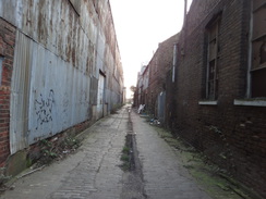
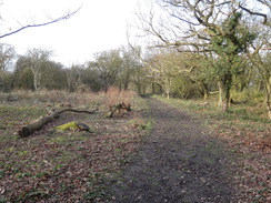
The trail passed into a dark, dank alley that headed between old factory buildings, most of which now appear to be out of use. Some of the shut ones were still in use when I first walked this way over ten years ago, but the alley itself did not really seem to have changed. From my perspective this was good, and the almost Victorian feel of the cobbled alley would contrast well with the rest of the days stroll. A faded memorial hanging off a palisade fence marks the spot where a plane crashed into the sea during the Second World War.
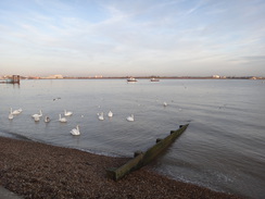
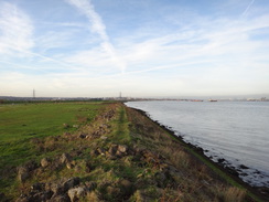
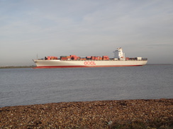
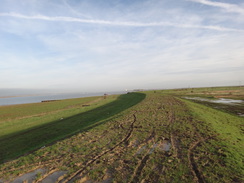
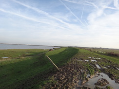
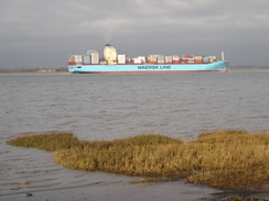
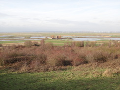
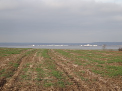
After passing the last few jetties, the path joined a grassy floodbank. The going was very boggy and waterlogged in places, and my new gaiters got a good try-out. A high bank behind a fence on the right marked a shooting range that thankfully was not in use. A large container ship made its way down the Thames, whilst coming upstream was a convoy of six immaculate pleasure craft; presumably making their way to the London Boat Show, which starts next week.
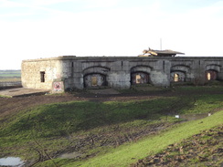
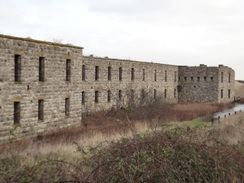
Sadly I could not admire the view for long as the going underfoot became tough as I approached the ruins of Shornmead Fort, built in the 1790s but used as practice by the Royal Engineers since the Second World War. Although most of the fort has been destroyed, the remaining casement wall gives a great idea of the size and prominence of the building. By the time I reached it, my feet were caked with mud, and I used a convenient post to try and scrape the worst of the mess off.
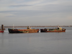
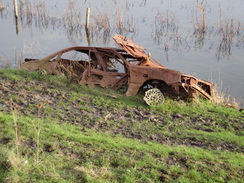
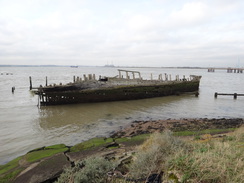
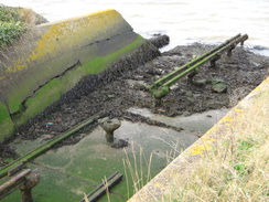
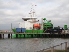
Thankfully the going became easier as the floodbank passed Higham Marshes, then turned to head north towards Cliffe. The casement wall of Cliffe Fort became visible ahead behind a large pile of aggregate. First I passed the hulk of a large sailing ship, the Hans Egede that was beached here before it could reach the breakers yard. Cliffe Fort has not suffered the ravages of the Royal Engineers and is still substantially intact, albeit inaccessible. A ship was offloading aggregate, but before I reached it I came across two sets of rails set only a few inches apart, which I recognised as the launch rails of a Brennan Torpedo, invented in 1876 and the first practical guided missile. The torpedo would slide down the rails into the water and then be guided by wires towards a target.
This marked the end of my Thameside walk on this trip, and the next water I would see would be the Medway. The trail followed the side of Cliffe Creek inland, then along a good track between flooded gravel pits. This stretch of path was pleasant, but became boggier as it joined another track that headed towards Cliffe. After passing the church I started chatting to a man who walked alongside me and asked what regiment I was with; he seemed rather bemused when I said I was not in the army and was doing this for fun!
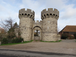
Muddy paths took me on into Cooling, where I passed the rather elegant gatehouse to Cooling Castle, built in the 1380s. Only small sections of ivy-clad curtain wall remain, but the ruins was fairly impressive nonetheless. It is strange to think that the castle, built at the edge of the marshes, is now two miles from the sea.
I stopped off at the pub in the village for a break, and took my gaiters and boots off outside before entering. The barmaid was very friendly, and soon I was eating a tasty plate of ham, egg and chips as we chatted away. I could scarcely afford the time away from the walk, but the opportunity to get a warm meal inside me was too good to miss.
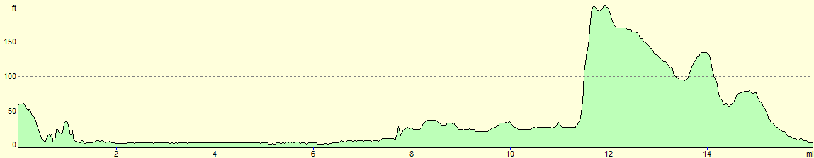
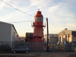
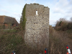
The meal had hardly settled before I started the only significant climb of the day, albeit an ascent of only 170 feet. It was an enjoyable climb, if only for the views back over the marshes to the northwest. An information board showed that the aerials marked on my map belonging to Cooling Radio Station had been removed, although the building was still present. The last antennaes on site were removed as late as 2005, the site having been used for radio testing before then.
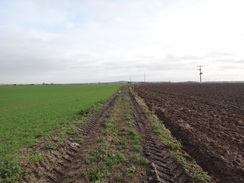
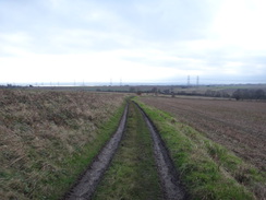
There were some pleasant views through the trees at the top of the hill, but these were lost as the path descended to cross a road. More paths led on to Fenn Street and beyond; a track on the other side was very rutted and boggy, making for slow progress on tired legs. The trail crossed a freight-only railway line that leads to the oil refineries and power station on the Isle of Grain, after which the going thankfully became easier.
I started to look for somewhere to camp as I walked along, although I had yet to reach the place I had selected for the night. The track passed a rather large house that looked spick and span; a man outside told me that it used to belong to the church but had now been converted to flats. The building was surprisingly large and appeared to have been renovated to a very high standard.
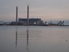
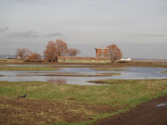
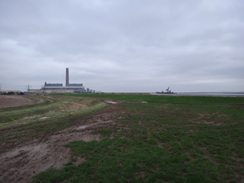
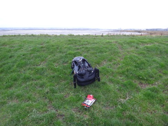
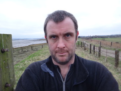
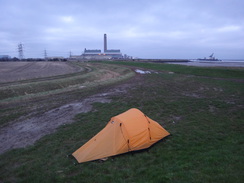
Shortly afterwards I reached the flood bank at the southern edge of the peninsular, right by the banks of the Medway. This was the spot that I had planned to camp, and there seemed to be no better places further along the trail. The grassy was muddy in places, but I found a reasonable spot in the lee of the bank, with the massive Kingsnorth Power Station as a backdrop. At the silly time of four in the afternoon I started erecting my tent in between chatting to various passers-by and dog walkers, all of whom seem intrigued by what I was doing.
Soon I was snug as a bug in the tent, although it was hardly a chilly night. One of the major problems with solo camping at this time of year are the long, interminable hours of darkness, with sixteen hours trapped in the tent. Fortunately I had packed my Kindle, which meant I could read for six hours before going to sleep.
It had been a very good days walk, which had ended with a rather unspectacular wild camp. January camping in lowland areas has to get better than this...
 |
 |
|
Directions
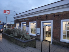
This walk starts off from Gravesend railway station at TQ645740. Leave the station by the main entrance and then turn right along the A226 Clive Road, keeping a wall guarding the station and railway line on the right. As the road curves to the right to cross the railway line on a bridge after 150 yards, turn left to head north up Stone Street, passing the side of a multi-storey car park on the left. When a crossroads is reached in the centre of Gravesend, head straight on down High Street, before turning left down an alley to reach Princes Street.
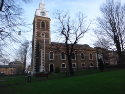
Cross Princes Street and turn half-right to join a paved path that passes some shops and a tourist information centre on the left. When the shops soon end, turn right to head north along a paved path across grass, passing close to St Georges church and a statue of Pocahontas on the right. The path leaves the churchyard through a gate to reach Church Street. Carefully cross the road and then turn left to follow the road as it curves to the right to reach a roundabout at TQ645744.
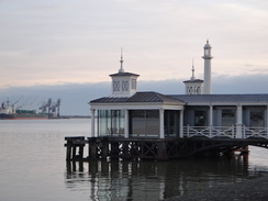
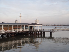
Just before the roundabout is reached, turn right down a pavement that leads to West Street coming off the roundabout. Turn right to follow the road east; cross over to the left-hand side of the road when you can. After 300 yards the road starts to curve to the right; as it does so, turn left down a paved path that heads down a slope to reach the end of Royal Pier Road, with the old St Andrews church and the river to the left. Follow the road as it curves to the right to head uphill; when the road ends at a T-junction, turn left along The Terrace.
As the road approaches some parkland in the grounds of New Tavern Fort, turn left back downhill; the road soon curves to the right. Pass a vehicle barrier and join a narrow grassy riverside path. Turn left to join the promenade beside the water. Follow the promenade as it curves to the right inland and climbs slightly to reach a road. Turn left to follow the road east; it soon reaches a rather ramshackle swing bridge over the entrance to a marina. Cross the bridge and follow a narrow road on the other side; when it forks head straight on along a cobbled lane between industrial buildings.
A fifth of a mile after the swing bridge, the road turns right and left along a narrow footpath that runs between palisade fences before joining the end of Wharf Road. After a quarter of a mile a road junction is reached; here turn left down Mark Lane. The road passes three solitary houses on the left, Woodville Cottages, and curves to the right. Do not follow the road around the bend, and instead head straight on for a few yards to reach the sea wall. Turn right to follow a walkway at the base of the wall; it passes the Ship and Lobster pub on the right, navigating any pubs and steps on the way. As the path and wall jink slightly to the right, turn left up some steps and through the wall, before descending to reach the end of a grassy flood bank at TQ668743.
There are actually two floodbanks; follow the one nearest the river as it passes under one jetty and across the access track leading to a second. After about three-quarters of a mile the bank reduces in height; cross a ladder stile through a fence and continue along the river edge past a firing range on the right. After another three-quarters of a mile the path climbs up to the right to join another floodbank; climb up onto this to reach Shornmead Fort at TQ692748.
Join the floodbank and start following it eastwards; it soon jinks to the left and right. Just before the right-hand bend at TQ697750 cross another ladder-stile. Continue on for a short distance and then turn left down a slope to reach a smaller bank nearer to the river. Follow this bank east-northeastwards; 1.3 miles after Shornmead Fort, a junction of paths is reached by an old pillbox at TQ710757.
Turn left to follow a path north, immediately squeezing past some anti-tank blocks to join a floodbank that runs between a flooded quarry on the right and the river on the left. After passing an old boat rotting away on the left, the path reaches a gate at TQ708763. Go through this and follow the path as it continues north; it soon reaches the corner of Cliffe Fort. Turn half-left to follow a path that passes a jetty on the left, soon afterwards reaching a narrow concrete channel that has to be negotiated via concrete steps - the rails belonging to a Brennan torpedo launcher can still be seen.
The path is eroding away, and so care is needed on the way towards a jetty belonging to an aggregate company. It diverts inland away from the jetty between fences to pass under a conveyor; carefully follow the signs through the area, to rejoin the flood bank on the northern side of the jetty. After another 250 yards the entrance to Cliffe Creek is reached at TQ708769. Turn right to follow the southern bank of the creek eastwards; after 0.4 miles the path goes through a clapper gate in a large fence and curves to the left past the end of the creek. Climb a couple of steps over a flood wall ahead, and descend down the bank to reach a very good-quality track.
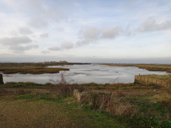
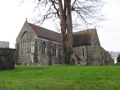
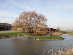
Turn left along this track for 100 yards, keeping the bank on the left, and then turn right down a gravel path that soon emerges out onto a bridleway. This heads between lakes that were once aggregate pits, but are now a nature reserve. After 0.7 miles the path ends at a T-junction with another track at TQ725764. Turn left and follow the track as it curves to the right; after 0.3 miles it goes past a vehicle barrier and curves sharply to the left. A few yards later turn right down another track that heads eastwards. After a third of a mile the track curves to the right to head uphill, joining a surfaced road with a farm on the right. Continue uphill along the road, passing houses on either side. When it ends at a T-junction head on up Church Street, passing Cliffe church away to the right at TQ736766.
When the road curves to the right towards the Six Bells pub, leave the road and continue straight on along a short, narrow lane that soon ends at Swingate Avenue. Turn left to follow the road as it heads eastwards; when it ends at a T-junction after 0.2 miles, cross the road ahead and continue on along a short lane that soon emerges out into a field. Follow the obvious path straight on between fields; after 0.4 miles it ends at Common Lane opposite Rye Street Farm.
Turn right to follow the road south; when it curves to the right after 200 yards turn left through a pedestrian gate beside a double field gate to enter a field. Follow a hedge on the right southeastwards; at the corner of the field turn left through a clapper gate into a second field, still following a ditch on the right. Soon afterwards in the corner of the field turn right across a footbridge over a ditch to enter a third field. Head across this, aiming for a clapper gate ahead that leads into a fourth field. Head diagonally across this field, aiming for the far corner where some steps lead up onto a road at TQ752758.
Turn left to follow the road eastwards for a quarter of a mile, passing the entrance to Cooling Castle on the left. As the road curves to the left past Cooling church, turn right and immediately left to join a path with a hedge and the churchyard on the left. Follow the hedge as it kinks to the right and then left before reaching a rough track. Turn left along the track which leads north for a short distance to reach Main Road in Cooling at TQ758760.
Turn right to follow the road as it heads past the Horseshoe and Castle pub and leaves the village; it winds around past Childs Farm. Half a mile after the pub the road curves to the right; just before it does so, turn left down a track that leads through an orchard. It soon curves slightly to the left, and after a sixth of a mile it curves to the right to approach Bromhey Farm. Cross a stile beside a farm gate and pass between two barns through the farm. On the other side join a track that climbs up a slight slope. As the track curves to the right, turn left down another track and pass a vehicle barrier beside a barn. The track curves right and the left.
Just before a farm gate is reached, turn right to join a path that initially follows a fence on the left. It soon curves to the right away from the fence and crosses a couple of bridges over ditches before starting to climb steeply uphill, the first significant climb of the day. It passes a well-placed bench and climbs some steps before the tree-clad summit is reached. Follow the obvious path across the summit before starting to descend slightly, before emerging out through a clapper gate into a field at TQ784760. Follow a hedge on the left eastwards towards the corner of the field; go through a clapper gate into a second field. Head straight across towards the corner of a ditch. Cross a farm bridge into a third field and follow a hedge on the left. When the hedge ends, continue straight on until a road is reached at TQ789762.
Turn right down the road and follow it as it immediately curves to the left. When it curves to the right once more, continue straight on eastwards across the middle of a field. After 250 yards cross a farm bridge over a ditch to join a green track; turn right to start following it south; after 0.6 miles it ends at a T-junction with a road. Turn left along the road for 150 yards until it reaches a roundabout with the A228 road. Carefully cross the A228 and turn right to follow it south.
Pass a cottage on the left, and just before a garage is reached turn left to skirt its forecourt. At the end of the forecourt continue along a narrow path, initially with a hedge on the left. It emerges out through a clapper gate to enter some orchards on the right. When the orchard ends, go through a clapper gate and cross a plank bridge over a ditch to reach a surfaced driveway beside Parbrook House. Turn right to follow the driveway southwestwards; when it curves to the right, continue straight on along a green lane for another 0.6 miles that descends to cross a bridge over a railway line at TQ792739.
Cross the bridge, and on the other side descend to join a better-quality track that passes Ropers Farm on the right. The track climbs slowly uphill; after nearly a third of a mile it curves sharply to the left and then right before ending at Ropers Lane. Carefully cross the road and go through a gate to join a farm track that heads southwestwards. When the track curves to the right after a fifth of a mile, turn left along a path that heads southeastwards for a quarter of a mile until it ends at a road at TQ789727.
Carefully cross the road to reach the pavement on the other side, and then turn left along the road for a short distance. Immediately after a driveway comes in from the right, turn right down a track. Follow this track as it heads in a rough southerly direction; after nearly half a mile a junction with another track is reached at TQ793721. Here the trail splits; if the tide is high, then you will need to turn right down another track towards the village of Hoo. Otherwise, continue straight on southeastwards along a good track that passes between two lakes before reaching the floodbank on the northern bank of the Medway, with Kingsnorth Power Station half a mile to the east. This walk ends here, at TQ797717.
 |
 |
|
Distances
| From | To | Distance (m) | Ascent (ft) | Descent (ft) |
|---|---|---|---|---|
| Gravesend station | Cliffe church | 8.3 | 180 | 203 |
| Cliffe church | Hoo Flats | 7.8 | 299 | 331 |
This makes a total distance of 16.1 miles, with 479 feet of ascent and 534 feet of descent.
For more information on profiles, ascents and descents, see this page
Accommodation
I spent the night camping beside the floodbank on the northern side of the Medway estuary at TQ797717, between Hoo St Werburgh and Kingsnorth power staton.
 |
 |
|
 |
 |
|
 |
 |
|
 |
 |
|
 |
 |
|
 |
 |
|
 |
 |
|
 |
 |
|
 |
 |
|
 |
 |
|
 |
 |
|
 |
 |
|
 |
 |
|
 |
 |
|
 |
 |
|
 |
 |
|
 |
 |
|
Disclaimer
Please note that I take no responsibility for anything that may happen when following these directions. If you intend to follow this route, then please use the relevant maps and check the route out before you go out. As always when walking, use common sense and you should be fine.
If you find any information on any of these routes that is inaccurate, or you wish to add anything, then please email me.
All images on this site are © of the author. Any reproduction, retransmissions, or republication of all or part of any document found on this site is expressly prohibited, unless the author has explicitly granted its prior written consent to so reproduce, retransmit, or republish the material. All other rights reserved.
Although this site includes links providing convenient direct access to other Internet sites, I do not endorse, approve, certify or make warranties or representations as to the accuracy of the information on these sites.
And finally, enjoy your walking!
Nearby walks
| # | Title | Walk length (miles) |
|---|---|---|
| 161 | Gravesend to Dartford | 7.2 |
| 176 | Gravesend to Rochester | 17.2 |
| 280 | Chalkwell to Stanford-le-Hope | 16.8 |
|
|

|