Walk #55: Peterborough to Whittlesey
General Data
| Date Walked | 20/11/1999 |
| County | Cambridgeshire |
| Start Location | Peterborough station |
| End Location | Whittlesey Station |
| Start time | 10.40 |
| End time | 12.20 |
| Distance | 8.6 miles |
| Description | This was a relatively short walk following the Hereward Way eastwards from Peterborough. |
| Pack | Today I carried full Pennine Way kit. |
| Condition | I feel fine after this walk, and have no problems to report. |
| Weather | Today was a mixture of sunshine and showers. It was quite a cold day, and indeed it was very bitter when I was in the wind on the exposed flood banks. |
| OS map | Explorer number 227 (Peterborough) |
Map of the walk
Maps courtesy of Google Maps. Route for indicative purposes only, and may have been plotted after the walk. Please let me have comments on what you think of this new format. For a detailed table of timings for this walk, please see the table file.
Notes
This was meant to be the day when I did the section of the LE-JOG route between March and Peterborough. Unfortunately, when I was at Ely both the ticket seller and the train guard told me that the 08.22 called at March when it did not. Thus I ended up in Peterborough. I could have walked the Peterborough to Stamford section instead but I had left the map for that section at home. Hence I decided to walk as far as Whittlesea whilst I was in the area. Hence I arrived at Whittlesea at 12.40 and had to wait until 14.20 for a train back to Ely.
Directions
From Peterborough station follow the signs for the main shopping area and the cathedral. From there, head towards the river and when you reach it turn left and follow the riverside path by means of a track, which initially is at the edge of a park.
Follow this path until you meet a road coming from the left. This road now follows the River Nene, and forces you to walk along the banking immediately beside it. This is a fairly straight and flat walk, and would be nice if it were not for the road beside it.
After a few miles you see the large Dog-in-a-Doublet sluice gates getting larger in front of you as you approach the. Just after you have passed the sluice, you meet a road junction at which you turn right to cross the river.
Immediately after crossing the bridge take a public byway to the left. After a hundred yards the byway turns right and shadows the road for a while across a very boggy area called the Washes before it angles back to meet the road.
Follow the road south into Whittlesey. When you reach a roundabout turn left and right by a cross across a marketplace. Continue along the road straight ahead as you pass past a leisure centre on the right and onwards down Station Road to the station.
Distances
| From | To | Distance (m) | Ascent (ft) | Descent (ft) |
|---|---|---|---|---|
| Peterborough | Whittlesey Station | 8.6 | 16 | 43 |
This makes a total distance of 8.6 miles, with 16 feet of ascent and 43 feet of descent.
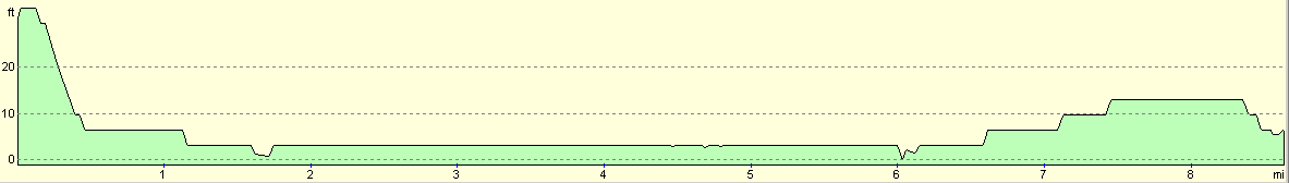
For more information on profiles, ascents and descents, see this page
Disclaimer
Please note that I take no responsibility for anything that may happen when following these directions. If you intend to follow this route, then please use the relevant maps and check the route out before you go out. As always when walking, use common sense and you should be fine.
If you find any information on any of these routes that is inaccurate, or you wish to add anything, then please email me.
All images on this site are © of the author. Any reproduction, retransmissions, or republication of all or part of any document found on this site is expressly prohibited, unless the author has explicitly granted its prior written consent to so reproduce, retransmit, or republish the material. All other rights reserved.
Although this site includes links providing convenient direct access to other Internet sites, I do not endorse, approve, certify or make warranties or representations as to the accuracy of the information on these sites.
And finally, enjoy your walking!
Nearby walks
| # | Title | Walk length (miles) |
|---|---|---|
| 56 | Peterborough to Stamford | 16.5 |
| 71 | March to Peterborough | 20.3 |
| 175 | Spalding to Peterborough | 19.5 |
|
|

|