Walk #60: Slough to Alperton
General Data
| Date Walked | 08/01/2000 |
| County | London, Buckinghamshire, Berkshire |
| Start Location | Slough |
| End Location | Alperton |
| Start time | 08.54 |
| End time | 14.19 |
| Distance | 16.7 miles |
| Description | This was a pleasant canal-side walk heading in towards the centre of London. Easy going along reasonable (although sometimes muddy) paths. |
| Pack | Today I carried full Pennine Way kit. |
| Condition | I do not feel particularly good after this walk. My feet ache slightly, and I am not feeling very well - I obviously have not really recovered enough from the flu that I had over the festive period. A couple of hot-spots on my feet, but no blisters. |
| Weather | Topday was a bright, sunny day. Periods where there were no clouds in the sky, and it was quite mild for the time of the year. |
| OS map | London A to Z |
Map of the walk
Maps courtesy of Google Maps. Route for indicative purposes only, and may have been plotted after the walk. Please let me have comments on what you think of this new format. For a detailed table of timings for this walk, please see the table file.
Notes
This was the first walk that I had done for three weeks, due to a bout of the flu that I had had over the Christmas period. I had intended to walk all the way between Slough and Paddington, but after I started walking I realised that I was still not 100% and decided to cut the walk short.
I also found out that the full distance to Paddington was 2.5 miles longer than I thought it was, due to a mistake guestimating the distance between Cowley Peachey Junction and Bull's Bridge. It was an incredibly silly mistake, I forgot to measure a map page in the guidebook. DOH!
Overall it was quite a nice walk. The Slough branch was quite nice in places, and I enjoyed walking the section eastwards from Cowley Peachey Junction as I had done that walk many times before when I lived in London.
Directions
From Slough station turn right out of the station and then right up the B416 and over the railway. Continue past an impressive church on the right until you reach the start of the Slough branch of the Grand Union Canal in a basin immediately after the Travis Perkins timber yard.
Follow the Slough branch of the Grand Union Canal from Slough basin eastwards for five miles until you reach the junction with the Grand Union canal proper at Cowley Peachey Junction. The towpath runs along the southern bank of the canal. Shortly before the junction you pass under the M25, showing that at last you have reached the outskirts of London. There are convenient milepost every mile along this branch, allowing some quite accurate timing of how fast you are walking.
When you reach Cowley Peachey Junction, cross the main canal via the 'Turn Around' bridge and turn right and head south-south east down the Grand Union Canal towards West Drayton. After a short while you reach West Drayton and the canal turns from heading generally southwards to heading eastwards. Continue along the canal until you reach Bull's Bridge. This is a stretch of canal where modern buildings are being erected - British Airways has a big building near Bull's Bridge. It has changed a great deal since I last walked it in 1995.
At Bull's Bridge turn left and follow the Grand Union Canal (Paddington Branch) for about 7.3 miles. It initially heads northwards before veering eastwards towards the centre of the capital. It is a walk of many contrasts, and although some areas are surprisingly rural you are never far from urban areas. If you are doing this walk as part of a Lands End to John O'Groats walk, it will be three or four days before you next see any real country scenes.
Just after Bridge 12 (a reasonably attractive brick bridge) there is a Sainsbury's on the right by the towpath, followed soon by another bridge, bridge 11. If you wish to finish the walk here, you can go up onto the bridge, turn left and then cross the road to the right to get to Alperton tube station which is on the A4089.
Further information
|
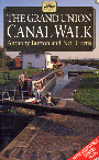
The walk is also covered in detail in the Grand Union Canal Walk, by Anthony Burton and Neil Curtis, ISBN 1 85410 244 3, published by Aurum Press Ltd. Click on the image to the right to go the Amazon page for this book.
For more details on the Grand Union Canal see Jim Shead's canal pages. |
|
Distances
| From | To | Distance (m) | Ascent (ft) | Descent (ft) |
|---|---|---|---|---|
| Slough | Cowley Peachey Junction | 5.7 | 75 | 79 |
| Cowley Peachey Junction | Bull's Bridge | 3.7 | 62 | 56 |
| Bull's Bridge | Alperton | 7.3 | 138 | 121 |
This makes a total distance of 16.7 miles, with 275 feet of ascent and 256 feet of descent.
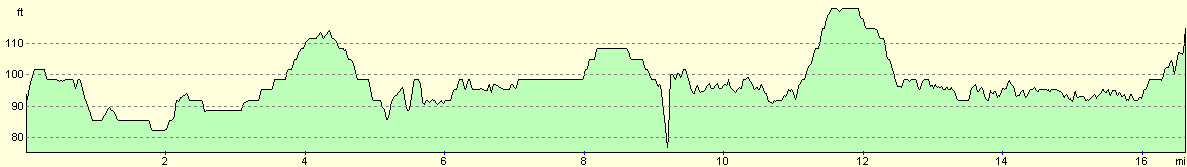
For more information on profiles, ascents and descents, see this page
Transport
There are trains roughly every half-hour from Paddington to Slough and vice-versa, and there are many intermediate stations en route, the most notable ones being West Drayton (near the end of the Slough Branch) and Southall (near Bull's Bridge). There are also many local bus services serving the local area. Alperton has a tube station which is on the Piccadilly line, allowing connections back into the centre of London.
Disclaimer
Please note that I take no responsibility for anything that may happen when following these directions. If you intend to follow this route, then please use the relevant maps and check the route out before you go out. As always when walking, use common sense and you should be fine.
If you find any information on any of these routes that is inaccurate, or you wish to add anything, then please email me.
All images on this site are © of the author. Any reproduction, retransmissions, or republication of all or part of any document found on this site is expressly prohibited, unless the author has explicitly granted its prior written consent to so reproduce, retransmit, or republish the material. All other rights reserved.
Although this site includes links providing convenient direct access to other Internet sites, I do not endorse, approve, certify or make warranties or representations as to the accuracy of the information on these sites.
And finally, enjoy your walking!
This walk was mentioned in the following routes:
| Grand Union Canal Walk |
| My sectional Land's End to John O'Groats walk |
Nearby walks
| # | Title | Walk length (miles) |
|---|---|---|
| 50 | Paddington to Mile End | 8.3 |
| 62 | Marlow to Slough | 16.3 |
| 65 | Alperton to Paddington | 6.4 |
|
|

|