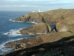
Walk #348: Porthcurno to Pendeen Watch
 |
 |
|
General Data
| Date Walked | 06/02/2003 |
| County | Cornwall |
| Start Location | Porthcurno |
| End Location | Pendeen Watch |
| Start time | 08.30 |
| End time | 16.40 |
| Distance | 14.6 miles |
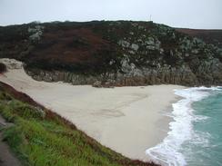
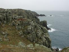
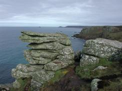
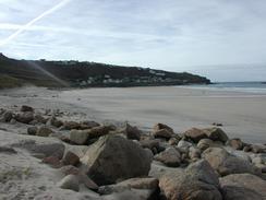
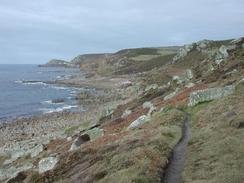
| Description | This was a lovely and scenic walk, with some fairly spectacular cliffs and views available at the westernmost point of England. |
| Pack | Today I carried my 30-litre Karrimor HotRock rucksack, which was filled with my packed lunch, waterproof leggings, water bottle and a couple of spare shirts, together with the usual assortment of odds and ends. |
| Condition | I am fairy fatigued after this walk, which is to be expected given the terrain underfoot on this walk. I had a few little twinges from my ankle during the course of this walk, but the worst thing was the fact that the underside of my feet ached after walking over the stony ground. |
| Weather | The weather first thing today was quite bad, with low cloud covering the cliff tops, and over the course of the morning this got me wet. By the time that I restarted the walk before midday the skies were clearing, and for long periods in the afternoon it was sunny, although there one small shower at Cape Cornwall. Later on in the day it started to cloud over once again, although thankfully it did not rain. |
| OS map | Landranger number 203 (Land's End & Isles of Scilly, St Ives & Lizard Point) |
 |
 |
|
 |
 |
|
Map of the walk
Maps courtesy of Google Maps. Route for indicative purposes only, and may have been plotted after the walk. Please let me have comments on what you think of this new format. For a detailed table of timings for this walk, please see the table file.
 |
 |
|
 |
Notes
Finally reaching Land's End after nearly 2,100 miles was quite an emotional moment for me. This target meant many things; it is me second right-hand turn, it is the start of my continuous Land's End to John O'Groats walk (which has always been an ambition of mine), and also completes a long circular walk around the south of England. Sam was waiting for me when I arrived, and we walked quickly over to the famous signpost to have some photos taken. Shortly after we had finished the man who runs the photograph booth arrived, and so we decided to pay to have my photograph taken with a sign saying 'Coastwalk 5,500'. The only slight problem with this is that I will now have to get a similar one when I get to John O'Groats! Land's End was also my second right-hand turn of the walk, and I now have a very long way to walk to get to the next one, at Cape Wrath in Scotland, which will be another 2,800 miles away.
After the photos had been taken we went to Mervan to pick up the sandwiches at Sam had made for me. After this I realised that I had plenty of time to complete the rest of the walk, and so I decided to go into the nearby pub and have a drink. The main reason for this was that we could see the clouds parting and blue skies ahead, so I thought it best to get out of the rain and dry off before setting out once again. This plan worked well, and I was much drier by the time I finally set off once again. In the pub we chatted to a few visitors, who seemed quite amazed by the distance that I had walked. It is exceedingly nice to get this reaction, as it makes me feel that the distance I have walked so far is impressive - strangely enough it does not seem very impressive to me. One of the problems with doing such a walk is that the entire previous trip becomes a blur in the memory - it seems like only yesterday that I was in Northumberland. This is one of the reasons that I am being so verbose when I write these journal entries - in future years they will give me memories that I would otherwise forget.
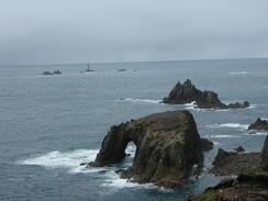
When I reached Cape Cornwall I was faced with a little choice - whether to walk up to the summit of Cape Cornwall or to just continue on along the South West Coast Path. After spending a couple of minutes prevaricating and wondering if I could justify the time (which is surely a contradiction) I decided to climb up to the chimney that marks the summit of the cape. The walk was short and easy, and the views from the top back towards Land's End and out to sea wee beautiful. I spent a few minutes beside the chimney, admiring the view and studying the map for the section ahead before reluctantly going down the hill back towards the car park and the path. As I neared the bottom of the hill I started to cry for some unknown reason, as the emotion of the day slowly worked its way to the surface. This emotion did not last long, and after it had finished I felt much better and started singing as I strode along the path.
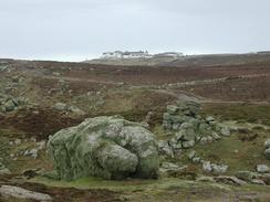
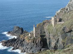
As yesterday Sam met me a few miles from the end of the walk, and we walked side by side and chatted as we went I really enjoy it when Sam does this, and although it slows me down it is nice to be able to talk to her and share the views and landscapes. Along the last section of the walk north from Cape Cornwall I passed through a large area with the remains of many tin mines in it. The skeletal remains of the buildings actually complemented the harsh landscape, and I enjoyed studying the old chimneys and the remains of buildings that were being subsumed by vegetation, slowly falling down and becoming part of the landscape that they once dominated.
Directions
| During this walk I followed the South West Coast Path, the route of which is detailed in the Ordnance Survey National Trail Guide 9, Padstow to Falmouth (ISBN 1-854108-50-6). Unfortunately the route description is written in reverse to the direction that I am walking, but the 1:25,000 maps in the book are clear and the signs on the ground are very good. Also to be recommended is the South West Coast Path Association guidebook (ISBN 0-907055-04-4), which has less concise directions and no maps, but includes accommodation details and grades each section of the walk according to difficulty. They also publish reverse directions, which are suitable for walking in the direction that I walked the route. They have a website at www.swcp.org.uk, which is well worth a visit. | 
|
| 
| |
| |
| |
Distances
| From | To | Distance (m) | Ascent (ft) | Descent (ft) |
|---|---|---|---|---|
| Porthcurno | Lands End | 4.8 | 1132 | 1083 |
| Lands End | Cape Cornwall | 5.8 | 1394 | 1457 |
| Cape Cornwall | Pendeen Watch | 4.0 | 748 | 728 |
This makes a total distance of 14.6 miles, with 3274 feet of ascent and 3268 feet of descent.
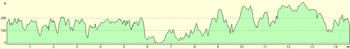
For more information on profiles, ascents and descents, see this page
Accommodation
The car park beside the lighthouse in Pendeen Watch has large signs stating no overnight parking, so we drove the short distance into the village of Pendeen and parked in the car park there for the night. There are some public toilets in the car park, and there is a pub just down the road and a shop directly opposite the entrance to the car park.
Disclaimer
Please note that I take no responsibility for anything that may happen when following these directions. If you intend to follow this route, then please use the relevant maps and check the route out before you go out. As always when walking, use common sense and you should be fine.
If you find any information on any of these routes that is inaccurate, or you wish to add anything, then please email me.
All images on this site are © of the author. Any reproduction, retransmissions, or republication of all or part of any document found on this site is expressly prohibited, unless the author has explicitly granted its prior written consent to so reproduce, retransmit, or republish the material. All other rights reserved.
Although this site includes links providing convenient direct access to other Internet sites, I do not endorse, approve, certify or make warranties or representations as to the accuracy of the information on these sites.
And finally, enjoy your walking!
This walk was mentioned in the following routes:
| My walk around the coastline of Britain |
| South West Coast Path |
Nearby walks
| # | Title | Walk length (miles) |
|---|---|---|
| 77 | Land's End to Zennor | 16.5 |
| 78 | Zennor to Gwithian | 14.4 |
| 347 | Marazion to Porthcurno | 14.1 |
|
|

|