Walk #542: Mulochy to Beauly
 |
 |
|
General Data
| Date Walked | 30/08/2003 |
| County | Highlands |
| Start Location | Munlochy |
| End Location | Beauly |
| Start time | 09.11 |
| End time | 15.39 |
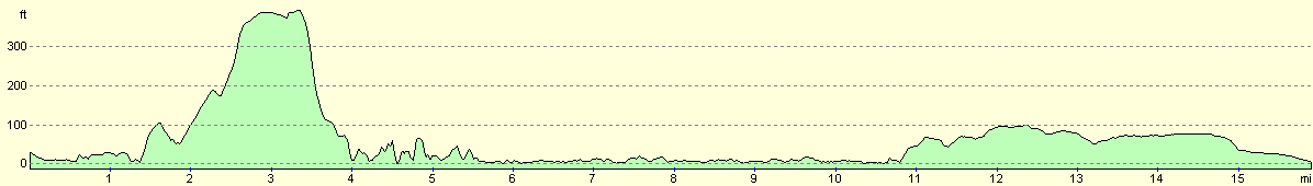
| Distance | 15.8 miles |
| Description | This was the shortest day for some time, but it was quite an enjoyable day nonetheless, with some nice views available over the Beauly Firth. |
| Pack | Today I carried my 30-litre Karrimor HotRock rucksack, which was filled with my packed lunch, waterproof leggings, water bottle and a couple of spare shirts, together with the usual assortment of odds and ends. |
| Condition | I felt absolutely fine for most of this walk until the very end, when my tight foot started to give me some gip, which is highly annoying. |
| Weather | This was yet another day of sunshine and showers, although the showers were less frequent than they had been over the last couple of days. There was also less sunshine, as the cloud cover was thicker for most of the day. |
| OS map | Landranger number 26 (Inverness & Loch Ness) |
 |
 |
|
 |
Map of the walk
Maps courtesy of Google Maps. Route for indicative purposes only, and may have been plotted after the walk. Please let me have comments on what you think of this new format. For a detailed table of timings for this walk, please see the table file.
Notes
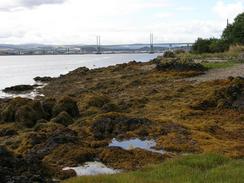
When I set off from Munlochy I was feeling fairly fit, and looking forward to the day's walk. I initially walked along the B9161 road before leaving it and heading along tracks along the south side of Munlochy Bay. The tide was out and I got some lovely views northwards over the mudflats, and I enjoyed this stretch of the walk immensely. When I had been studying he map last night I could see that it was pointless trying to walk around the end of the little peninsular at Craigiehowe at the eastern end of the bay; instead I decided to follow tracks past Craigiehowe Mains to Kilmuir. Unfortunately this was quite difficult; there were many tracks and junctions that were not marked on the map, and these made navigation quite difficult, particularly in the wooded areas. By dead reckoning I finally got myself to the little farm at Pitlundie, from where I could join paths that led to the little village of Kilmuir.
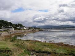
I quite liked Kilmuir, and I chatted to a couple of ladies who were walking a dog in the village. On the map there is a path that leads southwest along the foreshore under the flank of the wooded Ord Hill, and initially it was easy to follow this path. The tide was fairly low, which helped me as I crossed the foreshore on the faint path. Unfortunately once I reached a little ruinous hut near Croft Downie the path soon petered out at a large rock outcrop, which the tide lapped the base of. I did not really fancy scrambling over it, so I retreated back towards the hut and went up the hillside through woodland to the house at Croft Downie, from where I could follow the driveway down into North Kessock. In the village I saw a house that had an incredibly steep garden on the hillside behind it; there was a man doing some work on the garden from the steps that ran up the middle. I was quite amazed that a garden could be kept on such a slope, and in particular such an immaculate one.
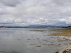
It had taken me longer than I expected to reach North Kessock, and so when I met Sam there we decided to have an early lunch. I did not want to eat too much as walking on a full stomach can be troublesome and give me stitch, but the meal was so lovely that I could not resist it. This gave me a long lunch break, but I realised that I did not have too much further to walk. The road that leads westwards from North Kessock along the northern bank of the Beauly Firth was narrow, but it was also very quiet and only a few cars passed me during the whole time that I was on it. The views over the Firth from the road were very nice, and I enjoyed looking across it as I was plodding along, wondering what adventures the other side would bring to me. The Beauly Firth is the last estuary that I will come across until I reach the Tay at Dundee, and hence I should be able to make some very good progress over the next few days.
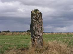
I was quite glad when I could get off the A832 road and join tracks that headed past Tarradale Mains towards Windhill, on the A862 road. The tracks started off surfaced, but soon deteriorated and became green lanes. Despite this, however, the going was good, and it was a far better alternative than walking along the main road. At Tarradale House there was a nice barn of Old Red Sandstone, sadly reroofed, and once I joined a minor road that led to the A862 I passed a nice standing stone in a field. I went to have a look at this, and it led me to wonder how old it was. I have passed so many standing stones on this walk, and I have very little information about any of them. The walk down the A862 was strange - I had walked up the road in the other direction on a previous walk, and it felt strange to be walking the opposite way. Just before I reached Beauly I saw a collie dog herding up chickens - a peculiar sight, particularly when the chickens started fighting back and nipping the dogs nose! I finished the walk at Beauly Priory, where Sam met me and we walked back to Mervan.
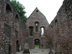
The day was necessarily short as Sam had arranged for us to go to the cinema to see the third 'American Pie film. We had seats booked for the six o'clock show, and as I wanted to have an enjoyable evening and not a hurried, rushed one, I finished the walk early so we could have a leisurely drive to the cinema in Inverness. We went to the shop in Beauly so that we could buy some grub for the show, and we also had a quick walk around the beautiful little town. The ruins of the Priory, which like many of the buildings in the town is made of Old Red Sandstone, dominate Beauly. It is a magnificent ruin, and is very well presented unlike many ruined buildings that I have seen on the trip. When Mary Queen of Scots saw the Priory she pronounced that it was a 'Beau lieu' (good town), from which the town's name was formed. The film was very good if you like that sort of thing, and as we drove back over the Kessock Bridge to get to Beauly the sky was just turning red as the sun sunk below the horizon, a marvellous end to the day.
I have got to the stage on this trip where if I do less than eighteen miles I feel like it was a bad day - this contrasts radically with how I felt at the start of the walk, where sixteen miles was a reasonable day. I am so much fitter now, and twenty miles does not feel very far at the moment.
Directions
This walk starts off at a car park beside the church in the village of Munlochy. Leave the car park and turn to the left to walk southeastwards down the B9161 road. Immediately after you cross a bridge over a stream turn to the left to walk eastwards down a farm access track. When this track curves to the right to head uphill to Bayhead Farm continue straight on down a much less distinct and boggier track that runs alongside the southern shore of Munlochy Bay. At the eastern side of Drumderfit Hill this track curves uphill to head southwards towards Bayfield and Craighiehowe Mains. From here I find it hard to give directions, as the tracks on the ground through the forested areas were different to those that I found on the ground, but basically I headed southeastwards along a track from Craigiehowe Mains towards Taindore, where I joined a road that headed southwestwards towards Pitlundie. Immediately before I reached Pitlundie Farm I took another track that headed southeastwards through the trees, and I then made my way down a steep hill until I hot a public road near the ruins of a church to the northeast of Kilmuir.
From the ruins I turned to the right and followed the road southwestwards through Kilmuir until it ended near a cottage. From here a footpath runs along the foreshore southwestwards, and is fairly distinct until I reached the ruins of an old boatshed. Here the path seemed to run out (or at last it did at the state of tide when I walked past), so I had to scramble uphill to the house at Croft Downie, where I could join a driveway that led down to a road in Craigton. When the driveway ends at the road turn left and follow the road as it heads under the large Kessock Road Bridge, which carries the A9(T) over the Beauly Firth. Continue on along the road as it heads westwards along the northern bank of the firth, heading through North Kessock and Charlestown before continuing on towards Redcastle, where the road swings to the right to head northwards. About a hundred yards after this bend turn left down another road that heads westwards for a mile through Milton before ending at a T-junction with the A832 road.
At the junction turn left and walk westwards for about a kilometre until the road curves to the right. At this bend turn left down a surfaced track that leads through the farm at Tarradale Mains and ends at a T-junction by a cottage. Turn left to head south down another track for a couple of hundred yards and then turn sharp right to head northwestwards along a green lane. After a few hundred yards this lane curves around to head southwestwards, and can be followed past Bellevue until it becomes a public road shortly before it meets the A862 road. When it does meet the A862 turn to the left and follow the road southwards for a mile into Beauly; this walk ends at Beauly Priory, which is on the left shortly after you enter the village.
Distances
| From | To | Distance (m) | Ascent (ft) | Descent (ft) |
|---|---|---|---|---|
| Munlochy | North Kessock | 5.8 | 794 | 823 |
| North Kessock | Beauly | 10.0 | 344 | 341 |
This makes a total distance of 15.8 miles, with 1138 feet of ascent and 1164 feet of descent.
For more information on profiles, ascents and descents, see this page
Accommodation
We spent the night parked in a little car park near the priory in Beauly. Despite being adjacent to a pub this was a quiet enough place to spend the night, and fortunately it did not get too noisy at any time. It was also quite handy for the local facilities, including pubs and shops.
Disclaimer
Please note that I take no responsibility for anything that may happen when following these directions. If you intend to follow this route, then please use the relevant maps and check the route out before you go out. As always when walking, use common sense and you should be fine.
If you find any information on any of these routes that is inaccurate, or you wish to add anything, then please email me.
All images on this site are © of the author. Any reproduction, retransmissions, or republication of all or part of any document found on this site is expressly prohibited, unless the author has explicitly granted its prior written consent to so reproduce, retransmit, or republish the material. All other rights reserved.
Although this site includes links providing convenient direct access to other Internet sites, I do not endorse, approve, certify or make warranties or representations as to the accuracy of the information on these sites.
And finally, enjoy your walking!
This walk was mentioned in the following routes:
| My walk around the coastline of Britain |
Nearby walks
| # | Title | Walk length (miles) |
|---|---|---|
| 192 | Lewiston to Beauly | 14.7 |
| 193 | Beauly to Garve | 16.4 |
| 539 | Arabella to Dingwall | 22.8 |
|
|

|