Walk #597: Mansfield to Matlock
 |
 |
|
General Data
| Date Walked | 20/03/2004 |
| County | Nottinghamshire, Derbyshire |
| Start Location | Mansfield Station |
| End Location | Matlock Station |
| Start time | 09.13 |
| End time | 16.14 |
| Distance | 21.2 miles |
| Description | This was a strangely satisfying road walk westwards from Mansfield to Matlock, taking in the two highest points in Nottinghamshire on the way. |
| Pack | Today I carried my 30-litre Karrimor HotRock rucksack, which was filled with my waterproof leggings, water bottle, trainers and a couple of spare shirts, together with the usual assortment of odds and ends. It weighed slightly more than usual as I also had a bit of extra kit, such as my Psion, battery charger and cables. |
| Condition | I am quite fatigued after this walk, which I find quite surprising considering the walk did not seem too hard. I wore my trainers for the first time on a walk, and consequently I have three little blisters on my toes. It is quite annoying that U feel so tired, but I guess that a contributory factor was the fact that I had not down any walking for a fortnight. |
| Weather | The main feature of today's weather was the wind, which was quite fierce at times. This was associated with light rain for most of the morning, and although I did not need my coat on until I reached Newton, when there was a heavy shower, the light rain was annoying as it was blown into me by the strong winds. Fortunately the wind, although strong, was warm, and I did not get cold at all during the day. |
| OS map | Landranger number 120 (Mansfield & Worksop, Sherwood Forest), Landranger number 119 (Buxton & Matlock, Bakewell & Dove Dale) |
 |
 |
|
Map of the walk
Maps courtesy of Google Maps. Route for indicative purposes only, and may have been plotted after the walk. Please let me have comments on what you think of this new format. For a detailed table of timings for this walk, please see the table file.
Notes
Another weekend, and anther opportunity to a walk. The main aim of the weekend was to go up to my parent's in Derbyshire to collect some of Sam's gear from storage, but on the way I thought that I may be able to get a day's walking in. Sam kindly agreed to act as my transport, and so I soon settled on a plan of walking from Mansfield to Matlock, taking in the two highest points in Nottinghamshire on the way. Most counties only have one highest point; Nottinghamshire is unusual, however, as landscaping of the old spoil tips of Silverhill Colliery has left it two metres higher then the previous county top; as the two points were only a couple of miles apart, I decided to walk to both of them.
It was quite a dreary day as Sam dropped me off at Mansfield railway station, which is hardly a great introduction to this part of Nottinghamshire. As I headed down the dual carriageway that runs through the centre of the town towards the bus station my opinion of the town did not really improve, and I saw absolutely nothing of any interest. I had never been to Mansfield before, and I saw very little to make me ever want to go back there again, which is a shame, although as normal I will add the proviso that my route may have been a very dull one, and missed out on things of interest. I tried to put a reasonably fast pace on to get myself out of the town, and it was a relief when I started to reach countryside and open fields near Skegby. This area used to be a busy coal mining area, and is criss-crossed by a series of old railway lines that have closed in relatively recent times. I could have followed one of these between Skegby and Teversal, but I decided to walk along a quiet country lane instead, which proved to be a little mistake later on.
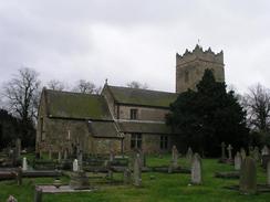
Teversal itself was quite pretty, and I was relieved that I was finally out into something that approached countryside. The church was worth taking a photograph or two of, and the entrance driveway beside it was lined with daffodils, making a pleasing view. My main aim, however, as to find my way into the Silverhill Country Park, and the highest point in Nottinghamshire on the old, landscaped colliery site. The landscaping was too recent to appear on my Ordnance Survey map, although I have later versions on my Anquet mapping system at home that show the paths. I initially tried to follow a track that heads northwestwards from Teversal, but after I passed a group of children playing football I reached a bridge over an old railway line, and a farmer told me that the correct route in was along the old line. I followed his instructions and walked along the old line, soon joining an area where the ballast was fresh, where the track had obviously just been lifted. Eventually I found myself in the country park and, once having looked at the large information board, started along the track that heads around the park.
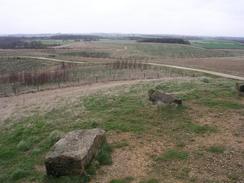
The walk around seemed to take an age, and to make matters worse the light rain was getting a little heavier. Eventually the small, conical hill that marks the new county top of Nottinghamshire became visible, and I walked quickly up to the top, which is at 205 metres above sea level. The views, although not brilliant, were very good, and I could easily make out the prominent Hardwick Hall to the northwest. I took a series of photographs, hoping to be able to make a panorama from them when I got home. I had my tripod with me, but due to the rain and wind I did not want to hang around for too long and took the photographs by hand. I had expected the colliery site to be fairly bleak, but, despite the wind, it showed great promise considering the colliery only closed in 1992. The area has been planted with trees that are still young and small, but over the years this could become a very nice place indeed. And, of course, the tress will hopefully protect walkers from the wind!
As the combination of the wind and rain was chilling me I jogged down the track to the exit of the country park to try and warm myself up. I left the park and walked through the tiny village of Fackley to reach the B6014 road. A little over a mile later I finally reached the old highest point in Nottinghamshire, which was beaten by the landscaped Silverhill colliery. The points is on Newtonwood Lane and lies exactly on the Nottinghamshire / Derbyshire border, and this made it slightly hard to find the exact highest point. Eventually I settled on a point, and I was more than under whelmed by the situation. A few metres away to the north (and on the Derbyshire side of the border) there lies a buried water storage tank, and the road itself is hardly inspiring. It was all quite depressing, and it seems a very good thing that this point has been replaced with the one at Silverhill Colliery, which is, over time, going to be a much nicer place to call a county top.
I did not want to hang around for long, so I hurried down the hill, passing an entrance to the southbound Tibshelf Services, and crossed the busy M1 on a bridge. The noise form the motorway was very intrusive, so I tried to hurry on along the road through Newton to Blackwell, where heavy rain forced me to take shelter under a bus shelter and put my coat on. More road walking took me on to Westhouses and eventually Shirland, where I finally started feeling as though I was getting into some 'proper' countryside. I walked to the village church and then crossed the A61, and plunged downhill to the B6013 and a bridge over the small River Amber. A long climb uphill then led towards Wessington, although before I reached the village I diverted northwards towards Brackenfield Green so that I could avoid the busy and winding A615 road. Brackenfield Green was a fairly pretty little hamlet, and I finally felt as though I had thrown away the shackles of the industrialised Nottinghamshire / Derbyshire border.
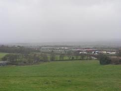
The long and slow climb uphill onto the tops was well worth it, as for the first time in the day some nice views were becoming available to the north and east. In particular, there was a viewpoint and car park at Highoredish from where here were some spectacular views down over Ogston Reservoir into Nottinghamshire. I stood at the viewpoint, which appears to be at the top of a small, disused quarry, taking photographs of the view. For the first time in the day I felt like the walk was actually good now that there were some views. Eventually I tore myself away, and headed on down the road, only to be stopped by some conifers that had been blown over by the wind. There were seven or eight of the, over the road, and I managed to squeeze past, although it was clear that the road would remain blocked to cars until someone got a chainsaw onto the job. As I continued on down the road towards Butterley I stopped he occasional car and told them that the road was blocked at the top of the hill - a few believed me, but a couple drove further on, and I saw them come whizzing past me a few minutes later!
As I reached the tops the wind started to hit me with it's full force. As usual with such gusting winds there were periods of relative quiet, and then suddenly a gust would come and hit me like a cushioned concrete wall, slamming right into my body. These gusts would also cause mw to stagger about in a manner not totally dissimilar to a drunk, and I wish that I could have been videoing my progress as I could have made some money from it. To make matters worse, the wind was picking up debris such as leaves and blowing them straight into my face, and this meant that I had to put my face down to avoid getting anything into my eyes. Although these gusts were stimulating, they were far from enjoyable.
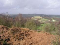
Once I reached the attractive little village of Tansley Knoll I was faced with a steep climb up a small hill along a track. At the top of this climb I got some good views over the Derwent Valley, including the impressive folly of Riber Castle on a hillside to the south. The descent down into Lumsdale eventually led me to the A632 Matlock to Chesterfield road, and the start of the outskirts of Matlock. Once across the A632 I followed a road to the top of Matlock Bank, and then turned to descend down the steep hill, which is flanked by buildings on either side. One of these buildings on the right was far grander than any of the others - this was Smedley's Hydro, built to service the holidaymakers who came to the town, and now the Derbyshire County Council Offices. The buildings are beautiful, although not best seen from the road on the eastern side, and I stopped to take some photographs before heading down to Crown Square and across the River Derwent to gain access to the railway station, where Sam was waiting for me. It was nice to be in Matlock again, a town where I have spent a great deal of time in the past, and I enjoyed reacquainting myself with the buildings and shops in the area - it was like seeing an old friend for the first time in years.
At the end of the walk I felt extremely tired, and indeed far more tired than the last 20+ mile walk that I did a couple of weeks ago. I thought that this may be down to the fact that I was walking into the fierce wind, but when I got back home and put my GPS track into Anquet maps, I was amazed to find that I had climbed over 702 metres during the course of the day's walk. This partially explains why I was so tired, and also makes me feel better about my slightly tardy progress during the day. Towards the end of the coastal walk I could do twenty miles a day every day easily, but now that I have a week or two gaps between walks those sort of distances are proving harder to do on a regular basis.
Directions
This walk starts off at the car park outside Mansfield railway station, in the centre of the town. Leave the car park and walk along the platform to gain access to a bridge over the A60 dual carriageway road. Once on the other side descend some steps to the right that allows access to the eastern side of the road. Walk along the pavement northwards until it nears the bus station, and then carefully cross the road and turn left to head southwestwards down the A38 Sutton Road. Walk along the road for a little over a kilometre until the junction with the B6014 road is reached outside the Sir John Cockle pub. Turn right and follow the B6014 Skegby Lane westwards for a couple of miles; at a crossroads it crosses the A6075 before continuing on into Skegby. The road descends down a slight hill and crosses a small stream before staring to climb uphill once more; just at the start of the climb turn right to head northwestwards up Buttery Lane.
After a couple of hundred yards the Lane swings sharply to the left; when it does this turn right to continue along Buttery Lane. This lane curves around a series of many bends, descending down to a bridge over a disused railway line before eventually settling onto a westwards course to enter the small village of Teversal. The road passes the church before ending at a T-junction with Pleaseley Road. Here I went in a slightly incorrect direction looking for an entrance to the country park (see notes above); instead I shall take you by a different route. At the T-junction turn left to walk southwestwards for a few yards to reach a bridge under an old railway line. At the bridge take a path that leads up onto it, and once on the bridge head northwestwards along a distinct path that heads into the country park. Once a large and prominent information sign is reached by a small pond turn right and follow a wide track that winds around the eastern side of the park, slowly climbing as it does so. When a fork in the track is reached on the northern side of the park take the left-hand one, which slowly ascends to pass a little conical hill, at the top of which is the highest point in Nottinghamshire.
Once at the top of the hill descend down it back to the track, and then turn right to head southwards to an entrance to the park, which is near to a caravan park. The entrance leads onto Silverhill Lane; turn left and follow the lane southeastwards for a short distance until it ends at a crossroads with the B6014 Tibshelf Road. At the crossroads turn right and follow the B6014 as it heads southwestwards for a few hundred yards, after which it curves to head in a westerly direction and becomes Wild Hill Road. A mile from Frackley a road junction is reached on the left, so turn left down this road (which is called Chesterfield Road), and follow it uphill for a few hundred yards until a road junction with Newtonwood Lane is reached on the right. Turn right down Newtonwood Lane and follow it westwards across the Nottinghamshire / Derbyshire border (which marks the old highest point in Nottinghamshire). The lane descends downhill and passes a back entrance to the Tibshelf Services before reaching a bridge over the M1.
Shortly after the M1 the road crosses over an old railway line on a narrow bridge before continuing on to end at a T-junction with the B6026 Hall Lane in Newton. Turn left along the B6026 road for a few yards before turning right along Alfreton Road near the George and Dragon pub. This road heads northwestwards through Blackwell and on until the road crosses a railway line and meets the B6025 road on the outskirts of Westhouses. Continue straight on along the B6025 road (which is still called Alfreton Road), and follow it southwestwards through Westhouses for a few hundred yards until a junction is met with Park Lane on the right. Turn right and follow Park Lane as it heads northwestwards for a couple of miles until it ends at a T-junction with the A61(T) Main Road in Shirland. Turn right along the A61(T) for a few yards until the church is neared, and then turn left to head downhill along Hallfieldgate lane. When the B6013 road is reached cross it and continue on the other side along Bumpmill Lane. At the bottom of the hill this passes under a railway line before starting to climb uphill.
A short distance up the hill turn right along Butterfield Lane, which heads northwestwards for a little under a kilometre before a road junction is reached on the left. Turn left and follow Millers Lane as it heads westwards uphill; when it meets a road junction cross the road that comes in and continue on northwestwards along Millers Lane, passing the village green on the way. When this road finally ends at a T-junction turn left to head westwards along School Lane until this reaches a crossroads with Carr Lane. At the crossroads continue straight on along a lane that heads northwards for a few yards before curving sharply to the left and climbing steeply uphill to the west. At a junction take the left-hand lane, which is called Coldharbour Lane, as it heads northwestwards passing a viewpoint and a picnic area on the way. Eventually Coldharbour Lane ends at a T-junction with the B6014 Butterley Lane.
At the junction turn right to head northeastwards along the B6014 for a few yards before turning left to head northwestwards along Gate Road. A little under a kilometre later there is a road junction; here turn left along another road for a few yards before turning to the right to head westwards along Allen Lane. At another road junction turn left along Whitelea Lane, which heads southwestwards along Whitelea Lane down into the village of Tansley Knoll. Just as you enter the village the Gate pub is on the right; pass the pub and then immediately turn right along Oaksedge Lane. This heads downhill to the northwest, and when it curves to the right at the bottom of the hill continue straight on along a track that climbs steeply uphill before descending down towards a pond. Once the pond is reached turn left and follow a rougher track that curves to the right before meeting Lumsdale Road. When this road is reached turn right and follow it as it heads uphill to the north, until a road junction is reached on the left.
Turn left and follow Asker Lane as it heads uphill; it curves to the right to head westwards to the A632 road. Cross the A632 and then continue straight on along Wellington Street. After a few hundred yards a junction with Bank Road is reached on the left; turn left and follow this road as it heads steeply downhill, passing Derbyshire County Council offices on the way. Bank Road ends at Crown Square in the centre of Matlock; continue straight on across the square and cross a bridge over the River Derwent. On the other side of the bridge turn right into a car park, and then left up to the forecourt outside Matlock railway station, where this walk ends.
Distances
| From | To | Distance (m) | Ascent (ft) | Descent (ft) |
|---|---|---|---|---|
| Mansfield Station | County top (Silverhill Colliery) | 5.4 | 545 | 282 |
| County top (Silverhill Colliery) | County top (Newtonwood Lane) | 2.2 | 197 | 171 |
| County top (Newtonwood Lane) | Shirland | 4.7 | 177 | 407 |
| Shirland | Tansley Knoll | 6.5 | 873 | 748 |
| Tansley Knoll | Matlock Station | 2.4 | 361 | 594 |
This makes a total distance of 21.2 miles, with 2698 feet of ascent and 2202 feet of descent.
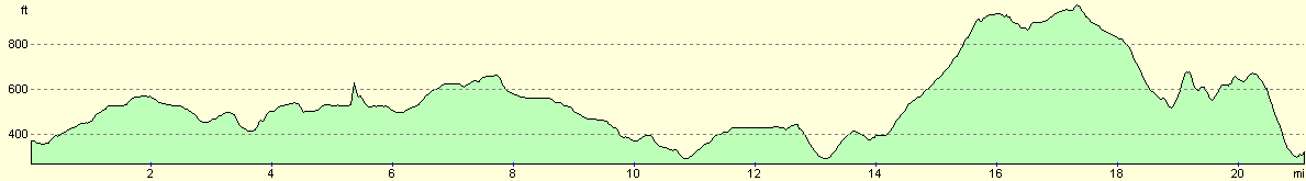
For more information on profiles, ascents and descents, see this page
Disclaimer
Please note that I take no responsibility for anything that may happen when following these directions. If you intend to follow this route, then please use the relevant maps and check the route out before you go out. As always when walking, use common sense and you should be fine.
If you find any information on any of these routes that is inaccurate, or you wish to add anything, then please email me.
All images on this site are © of the author. Any reproduction, retransmissions, or republication of all or part of any document found on this site is expressly prohibited, unless the author has explicitly granted its prior written consent to so reproduce, retransmit, or republish the material. All other rights reserved.
Although this site includes links providing convenient direct access to other Internet sites, I do not endorse, approve, certify or make warranties or representations as to the accuracy of the information on these sites.
And finally, enjoy your walking!
Nearby walks
| # | Title | Walk length (miles) |
|---|---|---|
| 11 | Stanton Moor | 2.9 |
| 12 | Darley Dale, Stanton Moor and Rowsley | 8.7 |
| 14 | Friden, Long Dale and Gratton Dale | 7.8 |
|
|

|