Walk #721: A circular walk from King's Cliffe to Rutland Water
 |
 |
|
General Data
| Date Walked | 15/04/2006 |
| County | Northamptonshire, Rutland |
| Start Location | King's Cliffe |
| End Location | King's Cliffe |
| Start time | 09.52 |
| End time | 17.28 |
| Distance | 21.6 miles |
| Description | This was an enjoyable stroll heading north from Northamptonshire into Rutland to the large reservoir of Rutland Water. |
| Pack | Today I carried my 30-litre Karrimor rucksack filled with my waterproofs, two litres of water, a book and various other odds and ends. |
| Condition | I feel absolutely fine after this walk, and the only minor problem that I have had is a little aching from my left knee. I feel far better than I did after last Saturday's walk, when I did three miles more distance. |
| Weather | The day started with a little fog in in the air, and although this had lifted by the time that I reached the start of the walk it was replaced by a layer of cloud. As the day went on this started to lift slightly to give some sunny periods. There was a little breeze, but despite this I would think that this had been the warmest day of walking that I have had of the year so far. |
| OS map | Explorer number 15 (Rutland Water) |
 |
 |
|
 |
 |
|
Map of the walk
Maps courtesy of Google Maps. Route for indicative purposes only, and may have been plotted after the walk. Please let me have comments on what you think of this new format. For a detailed table of timings for this walk, please see the table file.
 |
 |
|
 |
Notes
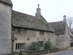
For a while now I have been completing a series of circular walks northwards from the A14 towards Rutland Reservoir. I still had one to go, and as I did not fancy driving too far I decided to complete this walk today. The drive went quite well, but once I got to King's Cliffe I could not find an obvious parking place. I ended up driving around, passing the church twice before eventually parking amongst resident's cars on a narrow road. It did not take me long to get my kit together, and I was soon walking back between the wonderful rosy stone buildings to the church.
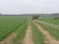
Once there I was quite keen to start the walk, so after taking a few photographs of the church and an adjacent memorial I started walking along the streets. King's Cliffe is a beautiful village, similar in feel to the nearby village of Easton on the Hill and, to a lesser extent, Stamford (which has been called the most beautiful town in England). I felt enchanted as I walked through, taking my time so that I could study all of the buildings as I passed them. Once on the very western outskirts of the village a road and then track took me northwards, passing over an old railway bridge with a partially filled-in cutting underneath it, and past a messy wood yard to reach the outskirts of Westhay Wood.
For the next few miles I followed the Jurassic Way as I headed westwards, initially following cool and wide forestry tracks through the woods. This was a fairly enjoyable stretch of walk, and although there was not much to see aside from trees I did not mind too much as the track curved to the right with an old cutting deep to my left and joining a road near Top Lodge. There was a visitor's car park here, and a sign inviting people to come and see some Red Kites in a large barn nearby. It was tempting to go in, but there was still a long way to go and so there was little alternative but to walk on. A short section of footpath that plunged through an short area of woodland led me down towards Fineshade Abbey where there were a couple of nice buildings (although nothing that looked like an abbey) and crossed a stream to reach the A43 road.
Beside the road to the left there were a few low grand buildings that were obviously an old gatehouse, and after looking at the map it seemed like these were associated with Laxton Hall, about a kilometre to the west. As I walked on the hall became visible for a short period, before the path plunged deep into Wakerley Great Wood, which seemed altogether darker and more enclosed than Westhay Wood had done. I passed a couple of other walkers before suddenly emerging into a clearing that housed a car park, and another path took me parallel to a road before dropping me onto the road a few hundred yards further on. The road was followed for another few hundred yards round some sharp bends before diverting off across a field past Wakerley Church and taking me into the village
Wakerley was also home to some pretty buildings, but seemed far more open and less enclosed than King's Cliffe had done. The route did not allow me to spend any time exploring the village, as it soon had me heading along a track north from the village, passing under an old railway bridge (the same line I crossed twice earlier in the day) before crossing a rather undistinguished bridge over the River Welland and entering the village of Barrowden. This was another quite picturesque village, particularly at the village green where I joined another road that took me out of the village. A long climb up a hill followed, as an attractive lady on a horse overtook me, and a similar long plod took me downhill towards South Luffenham.
It was tempting to go into the pub in the village to have a drink, but it was still early in the day and so I walked ton towards the church, which I could not get a good photograph of due to phone cables strung over the road nearby. The short walk through the village was very undistinguished, and before I knew it I reached a footpath that took me northeast away from the village. Initially this had some strange concrete slabs underfoot, but slowly the grass covered these up, leaving me wondering what the slabs were for, and if they hid anything underfoot. This footpath ended at another road, and to my right I could see the sad-looking stump of a windmill, the brick tower having no sign of the wooden top or sails that would once have bedecked it. Immediately after this the road crossed a level crossing and I continued on it towards North Luffenham, which I did not get to see much of as my route took me right along the edge of it.
On my map there was a trig pillar marked in an old disused airfield, and I had planned my route to take this pillar in. As I approached, however, I noticed well-maintained high wire fences, and regular warning signs stating the official secrets act. It was obvious that the airfield was still in use for some purpose, and I soon reached an entrance onto the site and some smart signs declaring that this was St George's Barracks, of the 1st Batallion The Kings Own Royal Border Regiment. There was an armed soldier at the gatehouse, and I waved before taking a couple of photos and heading on along the road towards the strangely-named village of Edith Weston. On the way I passed some typical spartan military blockhouses of absolutely no architectural interest, and to cheer myself up I diverted off course slightly to visit the Wheatsheaf pub.
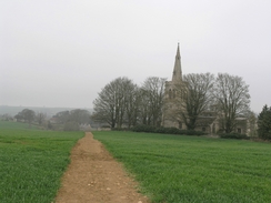
Inside I ordered a pint of beer and a pint of orange and lemonade, and as the sun was shining and it had warmed up I sat outside and slowly supped the pints. The seats outside the pub were busy with cyclists and walkers, and I started musing about days like this being exactly why I like walking. As I started to warm up I decided to take my fleece off, one of the first times this year I have been able to walk with it off, a sign of the late spring that we have had. Eventually I had drunk the pints and could wait no longer, so I gathered my kit together and started off down the road that led to the church. This was quite a small structure but was nonetheless fairly pretty, but as I wanted to get a move on I set off along the road, heading out of the village before joining a cycle path that runs along the entire edge of Rutland Water.
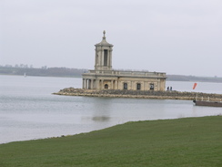
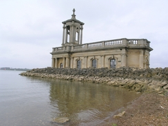
People were out in force on the path, and I frequently had to move off to allow cyclists to come past. A few years ago I cycled the thirty-plus miles around the reservoir and it had proved to be an enjoyable day out, but today I soon got fed up with having to move out of the way of all of the cyclists. The views more than made up for this, however, with the water glistening in the sunshine and the sailing boats on the reservoir looking beautiful as they glided across the water. Before I knew it I reached Normanton Church, which is situated on a little promontory away from the shore. The church was originally scheduled to be demolished when the reservoir was built, but after a campaign it was saved, with the undercroft being filled with concrete and the structure surrounded by rocks. It was definitely the right thing to do, as the white church is a magnificent sight, and blesses the reservoir by its presence. Inside the church is a little museum, but I did not go inside and instead walked around outside, looking at some of the detailing around the tower.
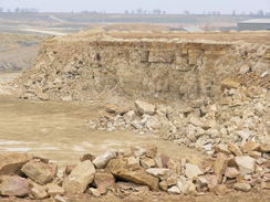
Eventually I tore myself away, and continued dodging cyclists as I headed northeastwards towards the reservoir dam, still enjoying the views. Once at the dam I left the cycle path and walked the few yards to the road, which took me northeastwards for about half a mile towards Empingham, before turning right to head uphill to meet the Hereward Way. I have walked this stretch of path a couple of times before, and it was just as I remembered it - not classic terrain, but an enjoyable enough stroll. The path took me uphill, passing a farm before reaching the large quarry that has recently grown over to the eastern side of the track. When I walked this way late last year it was pretty much in the same state, and I was surprised to see the lack of progress in the quarrying on the southern side of the track.
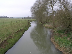
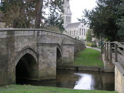
A long descent took me down a stony track to a road in Kettong, and I followed this through to the centre of the village and the church, passing a lovely memorial on the way. Ketton church is quite unusual, with the gateway at a right angle to the churchyard and old gravestones acting as a wall between the path and the churchyard. This seems like a good use of old gravestones, and certainly better than smashing them up, which is how most of them seem to go once the plots are reused. Past the church a footbridge beside an attractive road bridge took me over the River Chater, and on the other side a footpath headed uphill, crossing over a railway line on a abridge before depositing me unceremoniously on the road in Aldgate.
Shortly after this I joined the Jurassic Way, and headed off along a footpath out of the village before joining a long track that slowly descended down towards Tixover Grange. The sun was shining and the track seemed to gleam as it stretched away below me, and I found myself really enjoying this stretch. Past the grange another footpath led on, skirting the River Welland, where I passed some newborn lambs who were frolicking in the field. I did not follow the footpath under the road bridge, but instead ascended a ramp nearby onto the top of the embankment and crossed the road that way, heading into the village of Duddington and entering Northamptonshire as I crossed the Welland near a weir.
I stopped off to have a quick look at the church in Duddington, and then headed out of the village, which again had pretty stone houses. After passing a posh-looking pub and joining the A43 for a short distance, a track took me back into the depths of Westhay Wood. Whereas I enjoyed the stroll through the wood earlier in the day I now found it to be irritating, which was probably more a function of my tired state than anything else. Soon I rejoined the track that I had walked along earlier in he day, and as I passed through the wood yard I noticed a sign stating max 2MPH'. As I walk at three miles an hour I wryly wondered if the sign also referred to walkers.
After this it was simply a case of retracing my steps from earlier in the day back towards the church in King's Cliffe. Again I enjoyed the stroll through the village, and although I had been in a hurry in the morning I now found that I could take more time, strolling slowly and enjoying studying the building. On the outskirts of the village there was a chip van with a bunch of teenagers around it, and I found my stomach rumbling once the smell wafted towards me. I soon reached the church, and I looked back with satisfaction on what had been a good day's walk.
Directions
This walk starts off at the church in King's Cliffe. Leave the church and walk along the short road that leads to the high street in the village, next to a memorial. Turn left and start walking westwards through the village, passing a shop on the left until the road ends at a junction, and then turn right to start heading northwestwards along Wood Lane. This starts of as a residential road but soon ends as a track continues on, crossing an old railway bridge before reaching another track immediately by a wood yard. Turn left to follow the other track westwards, initially heading though the wood yards before plunging into Westhay Wood.
Here the route joins the Jurassic Way, which it will be following for the next few miles as it slowly curves to the right to take a more northwesterly course through the woods. The track jinks sharply to the right and then left before leaving the wood and joining a road, which is followed northwestwards for a short distance to Top Lodge. Pass a car park on the right and cross over an old railway bridge, and immediately on the other side turn left along a footpath that heads southwestwards downhill. The path enters a short section of woodland before descending to skirt past a building at Fineshade Abbey; just before it reaches Lynn Wood the path turns to the right to cross a stream on a concrete culvert. On the other side of the stream the path heads westwards across some hummocky ground to reach the A43 at Laxton Lodg Gates.
Cross the A43 and on the other side head straight on for about a hundred yards, before following the path as it turns to the right to head northwestwards into Wakerley Great Wood. The path continues straight on through the wood for about half a kilometre until a broad track is reached; here turn right and follow the track northwards for another couple of hundred yards until a car park is reached on the left. Turn left and walk along the northern edge of the car park, and when a turning circle is reached follow a narrow path through the woods to the right that heads northwestwards for a short distance before reaching a road. Join the road and follow it as it curves around to a more northerly course before jinking to the left and then right. Shortly after this last bend take a footpath that leads off to the left, heading northwestwards across a field with Wakerley church to the right.
The path ends at a road in the village; turn left and follow the path westwards as it passes a road junction on the left and heads on through the village. Pass a phone box on the left and shortly afterwards turn right down a track that heads northwards passing under an old railway bridge and continuing on to cross the River Welland on a footbridge. On the other side of the river the road joins a track that winds as it climbs up to end at a road in Barrowden; here turn left to head westwards along a road until a triangular junction is reached on the right. Here the route leaves the Jurassic Way as the road heads northwards, climbing out of the village and a kilometre later crosses the A43 road before descending down northwestwards to reach the A6121 road in South Luffenham.
Cross the A6121 and, keeping a pub on the left, head down into the village for a few yards before turning right along another road that heads towards the church; keep the church to the right and head northeastwards along another road until it ends after a couple of hundred yards at a T-junction with another road. Here turn left to follow the other road for a few yards, and before a stream is reached turn right along another footpath. Initially this has slabs underfoot as it heads northeastwards, but these soon end and the path crosses fields before passing between two hedges and ending at Station Road near an old windmill stump. Turn left and follow Station Road northwards, immediately crossing a railway line on a level crossing before crossing the River Chatter and climbing uphill to the northwest.
The road soon enters North Luffenham; at a crossroads continue straight on to head northwestwards along Edith Weston Road, which runs along the eastern edge of the village. The road curves to the right to head northwards out of the village and continues on for about a mile, passing an army barracks on the right before eventually ending at a junction immediately to the south of Edith Weston. Turn left and walk along the road for about a hundred yards, and once past the pub on the right turn right and head north towards the church. Before this is reached turn right, and head eastwards for a couple of hundred yards back through the village until it ends at another road. Here turn left, and follow a road northeastwards for a few yards until a track leads off to the left. Turn left down this track, and then turn right to join a cycle path that heads parallel to the road for a few yards, shortly reaching a car park.
Head through the car park and continue on along a cycle path that heads around the southern side of Rutland Water. Join this and follow it as it heads northeastwards, passing Normanton Church standing away from the water until eventually the dam is reached. At the dam turn right and follow a little path that leads up to end at a road. At the road turn left, and follow it as it heads northeastwards for about half a mile before it ends at a crossroads, and then turn to the right to head southeastwards uphill. After about half a mile when the road curves to the right, turn left to join a footpath that heads southeastwards, skirting the edge of Woodside Farm and continuing on uphill. After crossing a bridleway running along a green lane the path joins a track and passes high up through a working quarry, with the working faces clearly visible to the left. After this the track started to descend, passing through a farm before ending at the A6121 road immediately to the north of Ketton.
At the A6121 turn right and follow the road south through the village until it turns to the right, and turn left along another road that heads southeastwards towards the centre of the village. When the A6121 curves to the right turn left, and follow a road that heads eastwards for a short distance towards the church; pass this, and cross a bridge over the River Chater. When the road curves immediately on the other side of the bridge continue straight on along a footpath, that climbs a small slope before squeezing past a house and crossing a railway line on a high footbridge. On the other side of the bridge the footpath follows a track before ending at a road in Aldgate.
At this road turn right and start following it as it heads southwestwards through the village for a couple of hundred yards. A road joins from the right, and shortly afterwards the road plunges downhill and curves to the left. At this bend a footpath, signposted for the Jurassic Way, heads off up a little bank straight ahead. It heads southwestwards with high fences for houses on the right, and when these end the footpath heads southwards across a field for a couple of hundred yards, bypassing Kilthorpe Grange before ending at a track. Join this track, and follow it as it heads southwestwards down a very slight hill.
The track ends at a road to the north of Tixover Grange; turn left for a couple of yards and then turn right, cross a stile and head southeastwards for a hundred yards across a field, a task made harder by the hump in the field that means that you cannot see the exit point. The path ends at the road by Tixover Grange; turn right along the road for a few yards and then turn left to join a footpath. This skirts southeastwards, skirting the River Welland for a short distance before heading to the A47, where it heads under the road beside the river. On the other side it joins a road; turn left and follow this as it immediately crosses the river and enters Duddington; continue on the road as it passes the church, and at a junction turn right to head south for a couple of hundred yards until the A43 is reached.
At the A43 turn right along it for about fifty yards, and then turn left along a track after a cemetery. The track rises, initially heading southeastwards before curving to take a slightly more southerly course and diving into Westhay Wood. Once in the wood continue along the track for a couple of kilometres; when it ends at a T-junction with another track turn left and follow this track eastwards to the wood yard that was passed at the beginning of the walk. Once through the yard turn right, and follow a track southwestwards that becomes Wood Lane before ending after about half a mile at a road immediately to the west of King's Cliffe. Turn left and then almost immediately right, and follow a road eastwards through the centre of the village for about half a kilometre until the church is reached, where this walk ends.
Distances
| From | To | Distance (m) | Ascent (ft) | Descent (ft) |
|---|---|---|---|---|
| King's Cliffe | Barrowden | 5.7 | 449 | 429 |
| Barrowden | Edith Weston | 4.2 | 423 | 243 |
| Edith Weston | Ketton | 5.5 | 203 | 433 |
| Ketton | King's Cliffe | 6.2 | 367 | 337 |
This makes a total distance of 21.6 miles, with 1442 feet of ascent and 1442 feet of descent.
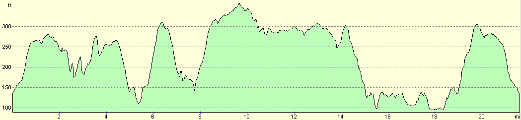
For more information on profiles, ascents and descents, see this page
Disclaimer
Please note that I take no responsibility for anything that may happen when following these directions. If you intend to follow this route, then please use the relevant maps and check the route out before you go out. As always when walking, use common sense and you should be fine.
If you find any information on any of these routes that is inaccurate, or you wish to add anything, then please email me.
All images on this site are © of the author. Any reproduction, retransmissions, or republication of all or part of any document found on this site is expressly prohibited, unless the author has explicitly granted its prior written consent to so reproduce, retransmit, or republish the material. All other rights reserved.
Although this site includes links providing convenient direct access to other Internet sites, I do not endorse, approve, certify or make warranties or representations as to the accuracy of the information on these sites.
And finally, enjoy your walking!
Nearby walks
| # | Title | Walk length (miles) |
|---|---|---|
| 56 | Peterborough to Stamford | 16.5 |
| 58 | Stamford to Oakham | 16.8 |
| 59 | Oakham to Melton Mowbray | 10.6 |
|
|

|