Walk #731: Wayland Smithy to Goring
 |
 |
|
General Data
| Date Walked | 11/06/2006 |
| County | Oxfordshire, Berkshire |
| Start Location | Wayland Smithy |
| End Location | Goring station |
| Start time | 05.55 |
| End time | 14.56 |
| Distance | 23.0 miles |
| Description | This was a long walk following the Ridgeway as it heads eastwards towards the Thames. |
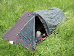
| Pack | Today I carried my 70-litre Craghoppers rucksack, including my Jack Wolfskin tent, sleeping bag and other camping equipment, although no cooking gear or spare clothes. With three litres of water the pack weight was about 15 kilograms. |
| Condition | The undersides of my feet suffered a little today, but this was relieved by taking my boots off at my stops. The main problem was the heat, which sapped my energy as the day got hotter and hotter. |
| Weather | The day was cloudier than yesterday, but these clouds were high up and sparse. In the early hours when I started walking it was nice and cool, but as the day drew on to midday it got increasingly warm. There wasa slight breeze that helped keep me cool at times, but if anything the heat was more oppressive than it had been yesterday. |
| OS map | Landranger number 174 (Newbury & Wantage, Hungerford & Didcot) |
 |
 |
|
 |
 |
|
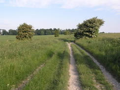
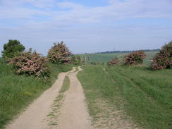
Map of the walk
Maps courtesy of Google Maps. Route for indicative purposes only, and may have been plotted after the walk. Please let me have comments on what you think of this new format. For a detailed table of timings for this walk, please see the table file.
 |
Notes
I awoke at dawn, which at this time of year happened far too early. My night's sleep had been interrupted by children yelling at about half past midnight, but otherwise my sleep had been deep and uninterrupted. When I awoke I read for a while by the sparse light, and eventually at five I got dressed (which is difficult to do in my Jack Wolfskin tent) and went outside. It was a glorious morning, with some thin, high cloud overhead, which was a pleasant change from the near-cloudless skies of yesterday. I moved my inflatable mat out of the tent onto the side of the adjacent Wayland Smithy's long barrow, and read a book for a while.
After reading and generally mincing around for a while I decided to get moving, and by five minutes to six I had taken my tent down and was on the move. I walked around the barrow once to have a last look at it; one of the other campers was already up and we exchanged pleasantries quietly before I left the barrow and rejoined the Ridgeway. The morning was superb, refreshingly cool after the heat of yesterday, and it made for a really nice walk. Before I knew it I had reached Whitehorse Hill, and I diverted off the track to reach the trig pillar that stands on the bank of the hillfort. The views were superb, albeit slightly hazy, and it was tempting to go down the hill so that I could get a view of the ancient, stylised horse cut into the chalk hillside, which gives the Vale of the White Horse its name. Eventually I decided against it, but after walking around for a few minutes I returned to the trig pillar and studied the views. When I got back home I discovered that the trig pillar is the highest point in Oxfordshire, and that I had therefore visited yet another county top without realising it!
The trail headed eastwards from Whitehorse Hill, descending before climbing up the flank of nearby Rams Hill and continuing on. At Hill Barn there was a drinking water tap, and I took my rucksack off so that I could retrieve all of my bottles. After repeatedly saving a large spider that kept on climbing up into the tap spout whenever I switched the water off, I took a walk across a field to the trig pillar in a nearby pillar, from where there were some good views. It was still early in the day and there was absolutely nobody about, and the trail felt eerily empty. I swigged down a litre of water from a bottle and refilled it, rescuing the spider once again in the process.
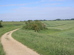
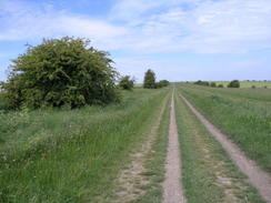
The next few miles were superb, and I really enjoyed the walk as it passed the Devil's Punchbowl, a large valley immediately to the north of the track, and continued on, slowly climbing and falling as it headed along the ridge. Eventually I reached a large stepped monument that stood beside the track, and I decided to stop and have a rest. The monument is a memorial to Robert Loyd Lindsay, Lord Wantage, and it was erected in 1901 by his wife. He was an interesting man; he was the first to be awarded the Victoria Cross during the Crimean War, and was also a founding member of the British Red Cross. The monument comprises of wide steps leading up to a tall shaft, which is topped with an ornate cross, and the steps made for a good place to rest, with superb views to the north. I took my boots off, and was slightly surprised to find a solitary thick sock laying on the stone slabs near my pack, left behind by some previous walker.
I used the opportunity to phone Sencan, and as we chatted I admired the panorama that stretch out before me. Once I felt that I had had enough of a rest, I put my boots back on, heaved my rucksack onto my back and set off. My feet felt better for the rest,and I soon pressed on eastwards, hoping to walk for another couple of hours before my next rest. For most of the day the Way was heading in a more or less easterly direction, slowly climbing and falling as it did so with no great altitude changes. A trig pillar was marked on the map on Fore Down, and as I got in the general area I kept my eyes open for it. I soon spotted it through a hedge, but unfortunately it was on the wrong side of a fence, and amidst nettles. It was very close, so I took some photos of it through the strands of wire, but I did not facny taking my pack off and finding a way around the fence to actually visit it, particularly with the surrounding nettles.
Instead I plodded on, the day getting warmer and warmer, making me realise how wise it had been to set out when it had been cooler earlier in the morning. This led on to Bury Down, and as I approached the A34(T) the heat started to get to me. I had really wanted to cross under the road before stopping, but eventually my feet were complaining too much, so I found a convenient grassy spot just off the track, dropped my rucksack off, and sat down. I slowly fanned my face with my Tilley Hat to try and cool myself down before taking my boots off and stretching my legs straight across the grass, my feet pointing towards the track. After a few minutes I had cooled down slightly, and I started reading the National Trail Guide to see what else was to come in the day.
I was deep in thought when I heard a voice, and it was one of the cyclists whom I had camped next to last night. We chatted for a few minutes whilst his friend caught up, and it turned out that they had set off at about 08.15, about two and a half hours after me, and yet they had already caught up with me! They looked much fresher than I felt, and I started to think that cycling is a much more sensible form of transport than walking! Apparently they had been keeping their eyes open for me, and were glad that they had finally caught up with me. They told me that they were abandoning their plans to only go as far as Goring, and were instead going to continue along the Way to nearer their homes in Hertfordshire. They soon set off once again, and they left me feeling slightly low, as I was aware that I had not gone as fast as I wanted this morning, and it was now too hot for me.
Before I set off once more I rubbed my feet for a while, as this usually helps stop them from aching too much. Once I finally set off once again the underpass under the A34(T) was soon reached, and on a couple of panels of this was a well-painted scene of local life. After this the way ascended up Several Down, with gallops to the right. Over the last couple of days there had been a few of these beside the trail, and I can only assume that a significant industry in this area is racehorse training. The climb was gentle enough but I sweated anyway in the heat, and it was a relief when the Way turned sharply to the left to descend down a slope to meet an old railway line. The downhill stint was a relief, and to the left was another set of gallops, this one with some jumps set up.
Unfortunately as soon as the old railway line was crossed I was faced with a climb up onto Roden Downs and then onto Thurle Down. This was not a steep ascent, but there was little cover to be had from the fierce sun, and the heat was draining as I slowly plodded up the hill with sweat pouring down my forehead into my eyes. I found myself being annoyed by the fact that I normally would have had no difficulty in climbing this slope, and that the hot weather was making it so much more difficult. The next mile was fairly level as the Way headed to the south of Lowbury Hill, and after this I was greeted with a descent downhill. Thankfully here there were some trees lining the track, and this gave me some cover from the trees.
As I approached Warren Farm, where the road begins, I started to think about train times. Looking at my watch I could see that I could just about reach Goring station in time for the next train in a little under an hour, but that it would be hard going, considering my rough condition. Instead I found a nice patch of grass near the farm and sat down, taking my rucksack and boots off before collapsing further to a recumbrant position. I was absolutely exhausted, and I decided to rest for half an hour, which would give me half an hour leeway to get to the station in time for the train after next. I lay back and rested, watching people come and go from the farm; I think that a barbecue or similar event must have been going on, as people were arriving and walking about with various goodies.
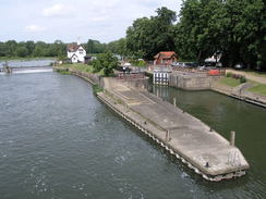
It was a restful time, but eventually I had to go, and so I put my boots back onto my feet, shouldered my rucksack and headed off. The next couple of miles were along what seemed like an uninterminably long road, with little of interest to see as I strolled to take my mind off my aching feet. I was also short on water, and whilst I had a little left in a bottle I was trying to use it scarcely - this was silly, as I was very near to civilisation. It seemed to take an age to reach the A417, which took me down the short distance to Streatley, a village I found that I instantly liked. There were some buildings with interesting architecture, but I did not stop to study them and instead dropped down the slight hill to the bridge over the river, and I was greeted with some superb views towards the weir and lock on the Thames.
After walking for two days, it was nice to see the Thames, which is literally a significant point in the Ridgeway National Trail - not only is it the halfway point, but it is also the point where the high ridge walk through Wilshire and Oxfordshire becomes a very different walk as it enters the Chilterns. I stopped on the bridge and watched a boat exit the lock, and was warmed by the sight of people enjoying the very same sunshine that had caused me so much trouble. With the end so near I ignored the pubs in the area and even walked past an open newspaper shop (despite being tempted to go and buy a bottle of water) and walked on to Goring station. It was an easy walk and I arrived there about half an hour before the train was due. After nipping into the station to check that the train was on time, I walked out to the pub, (which I think was called the Queens Arms) to wait.
There was world cup football on a large screen in the pub, and therefore the best place to sit was by the pool table, away from the screen. As soon as I stopped walking the heat hit me, and I drunk a pint of beer and a pint of orange and lemonade to cool me down. This helped matters, and also had the advantage of making the wait for the train less boring. The train was punctual but was also stifingly hot, and the first thing I did when I arrived back at home in the mid-evening was have a shower to try and cool myself down. It had been a great weekend's walking, and had set me up well to complete the Ridgeway National Trail later on in the year.
Directions
|
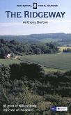
The walk is covered in detail in the Ridgeway National Trail Guide, by Antony Burton, ISBN 1 84513 063 4 published by Aurum Press Ltd. Click on the image to the right to go to the Amazon page for the book. The exception to this is for the last half mile or so of the day in Goring. When the Way turns left off the B4009 after having crossed the Thames, to head north up Thames Road, continue straight on eastwards through the town. This road crosses a railway line on a bridge and immediately afterwards a road junction is reached. Turn right wand head southwards down this road for a hundred yards to Goring railway station, where this walk ends. |
 |
Distances
| From | To | Distance (m) | Ascent (ft) | Descent (ft) |
|---|---|---|---|---|
| Wayland's Smithy | Wantage Monument | 10.1 | 755 | 764 |
| Wantage Monument | Lowbury Hill | 7.8 | 315 | 538 |
| Lowbury Hill | Goring station | 5.1 | 302 | 600 |
This makes a total distance of 23.0 miles, with 1372 feet of ascent and 1902 feet of descent.
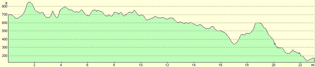
For more information on profiles, ascents and descents, see this page
Transport
If you wish to get back to Avebury (the start of yesterday's walk) from Goring, there are regular train services from Goring to Swindon, changing at either Didcot Parkway or Reading. You then have to change to take the 49 bus service to Avebury (the Swindon - Devizes - Trowbridge service), which runs hourly on Mondays to Saturdays, and two-hourly on Sundays.
Disclaimer
Please note that I take no responsibility for anything that may happen when following these directions. If you intend to follow this route, then please use the relevant maps and check the route out before you go out. As always when walking, use common sense and you should be fine.
If you find any information on any of these routes that is inaccurate, or you wish to add anything, then please email me.
All images on this site are © of the author. Any reproduction, retransmissions, or republication of all or part of any document found on this site is expressly prohibited, unless the author has explicitly granted its prior written consent to so reproduce, retransmit, or republish the material. All other rights reserved.
Although this site includes links providing convenient direct access to other Internet sites, I do not endorse, approve, certify or make warranties or representations as to the accuracy of the information on these sites.
And finally, enjoy your walking!
This walk was mentioned in the following routes:
| The Ridgeway National Trail |
Nearby walks
| # | Title | Walk length (miles) |
|---|---|---|
| 730 | Avebury to Wayland Smithy | 23.3 |
| 738 | Thames Path: Oxford to Cholsey | 27.3 |
| 739 | Thames Path: Cholsey to Shiplake Lock | 22.7 |
|
|

|