Walk #798: A circular walk from Litchfield
 |
 |
|
General Data
| Date Walked | 14/11/2007 |
| County | Hampshire |
| Start Location | Litchfield |
| End Location | Litchfield |
| Start time | 07.39 |
| End time | 16.18 |
| Distance | 24.1 miles |
| Description | This was a pleasant circular walk based on the northern sections of the Wayfarer's Way |
| Pack | Today I carried my 30-litre Karrimor rucksack, filled with waterproofs, a book and other odds and ends. |
| Condition | I am tired after this walk, but otherwise feel fine. |
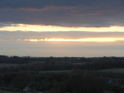
| Weather | The day was a mixture of sunshine and cloud, with a slightly chilling breeze. There was no sign of any rain. |
| OS map | Landranger number 185 (Winchester & Basingstoke, Andover & Romsey) and Landranger number 174 (Newbury & Wantage, Hungerford & Didcot) |
 |
 |
|
 |
 |
|
Map of the walk
Maps courtesy of Google Maps. Route for indicative purposes only, and may have been plotted after the walk. Please let me have comments on what you think of this new format. For a detailed table of timings for this walk, please see the table file.
 |
 |
|
 |
 |
|
Notes
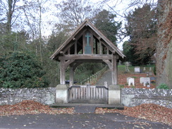
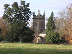
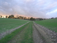
Recently I completed the Test Way, and when I reached the end of that walk I reached the start of another, the Wayfarers Walk, which heads southeastwards to reach the sea at Emsworth near Portsmouth. Today I decided to do the second stretch of this walk, using a circular walk based on Litchfield. This involved me driving up the M3 and A34 to find the small village of Litchfield, situated right by the A34 road. It was difficult to find somewhere to park, but eventually I pulled up in a little dirt layby opposite the church. I was slightly nervous about leaving my car here, but could see little alternative.
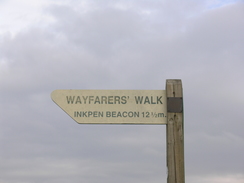
My first task was to reach the start of the Wayfarers Walk at Inkpen Beacon. Initially I followed a footpath that immediately headed under the A14 before climbing uphill. This dropped me down at Dunley Manor; here I went wrong and turned right, climbing along a track uphill for a hundred yards before realising that I had gone wrong. I soon headed back and joined the road and followed this north to Lower Woodcutt Farm, where I walked on my previous walk along the Wayfarers Walk.
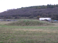
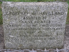
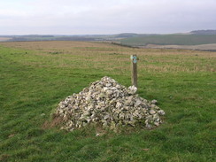
A track took me uphill, and soon I was at the edge of the ridge. The previous day had taken me along this ridge, in what had been a superb day's walk. I did not know what to expect from today; only that the views would probably not be as good. Initially this turned out to be the case; the Wayfarers Walk descended down to the east, getting lower and cutting off the views. It eventually reached the A34 at Thorn Down. Off to the left there were some barrows, but of more interest to me was a plaque stating that this was where Geoffery De Havilland took his first flight (and also, shortly afterwards, his first crash). Where a plane once flew, cars now drive. Yet our ancient ancestors were there first.
The crossing of the dual carriageway looked slightly nasty, so I took a signposted diversion to the south. This skirted the bottom of the A34's embankment for a couple of hundred yards southwards until a underbridge is reached. I passed under this, and then followed another path that headed north, climbing above the A34 until reaching the Wayfarers Walk once again. Off to the left there was a small railway underbridge; this is the old Winchester to Newbury railway line, much of which was obliterated when the A34 was constructed.
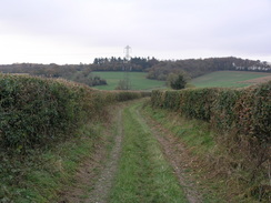
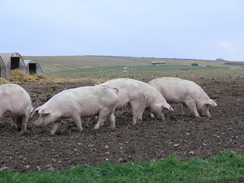
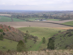
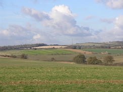
The Wayfarers Walk started climbing eastwards up a dry valley, quickly gaining some of the height that bad been lost. This led up onto Great Litchfield Down, where a surrounding pig farm added a certain odour into the air. The views continued to expand as the path slowly climbed to reach the ramparts of an old hill fort on Ladle Hill. From here the path followed tracks eastwards, crossing a road and then approaching a trig pillar. This was above Watership Down, the destination of the rabbits in Richard Adams' eponymous famous book.
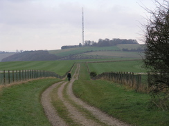
The path passes a series of gallops as it continues skirting the top of the escarpment eastwards. Some of the views ahead were very good, and it was an enjoyable stroll in the dry weather. The ridge was finally left behind at the B3051 road, where the Wayfarers Walk turned to make a more southeasterly course. The scenery consequently became less interesting, although it was still scenic as a long track took me south to North Oakley.
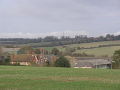
South of here the path became more disjointed; climbing and falling as it wound around, finally settling on a rough southeasterly course. I was feeling fine, and turned up the music on my walkman as I strolled along. A short stretch of road was followed near Deane Down Farm, and the path then crossed a railway line on a high bridge. A slow descent then took me down into Deane. I walked along the road southwards, eventually reaching the B3400. The Deane Gate Inn was on the other side of the road, so I crossed over and nipped in for a quick drink. I could not afford to spend too long in the warmth, and too soon I was heading out once again.
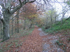
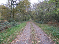
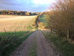
I retraced my steps for a short distance, with Deane Church a short distance away to the left. I then left the Wayfarers Walk and started heading north along a road. Shortly after this crossed over the railway line I turned left along another road. There was not much to report about this stretch of the walk, and it was a relief when I turned off to join a track called the Harrow Way. This was a much more enjoyable stroll, with some occasional good views to be had. I put my head down and walked, listening to some podcasts as I did so.
I left the Harrow Way just before it reached a road, and turned right to follow another track northwards. This joined a road at Whitnal, and I continued on along this until it ended at another road. More footpaths took me along to cross the Portway, the old Roman Road between London and Weymouth. As usual when crossing such roads, I tried to imagine Roman Legionnaires walking along it; unfortunately it was quite hard to do this here due to the very un-Romanlike surroundings.
By this time it was starting to get a little late, and I was also getting slightly tired. A path descended down to a road at Owls Lodge, and then a bridleway followed a track uphill. There was a covered reservoir at the top of the hill, and I then started the long descent down to Litchfield and my car. It had been a long day of 24.1 miles, but the views had more than made up for the strain. I can scarcely wait for the next stretch of the Wayfarers Walk.
 |
 |
|
 |
 |
|
Directions
This walk starts off by the church in the village of Litchfield. Head south from the church for a short distance, and then turn right past a farm, before joining a footpath that heads over a bridge that crosses the A34(T). On the other side the track turns to the right; follow it parallel to the road for a few yards, and then as it turns sharply to the left to head southwestwards up a hill. The path crosses the brow of the hill, and then descends to meet a track by Dunley Manor. Turn left to head southwards for a short distance until a road is met.
Turn right along this road, and follow it as it heads westwards; it then curves sharply to the right and then the left to head northwards towards Lower Woodcott Farm. As the road curves sharply to the left just beyond the farm, turn right along a track that heads uphill to the northeast; the ascent gets more gradual until after about half a mile it ends at a T-junction with the Wayfarer's Walk, which will be followed for much of the day, Turn right and start following the Wayfarer's Walk as it heads eastwards along the top of a little ridge. After a mile it descends to meet the A34(T); this road is busy, and instead of crossing it on the level you can turn right to walk south parallel to it for a third of a mile until a tunnel under the A34 is reached. On the other side turn left, climbing up to join a footpath that heads north alongside the A34(T) until it is opposite the point we were before.
Turn right to start heading eastwards uphill along a rough track. This curves to the left under some power lines towards a band of trees, passes them and then turns to the right to walk along the northern end of the trees. It continues eastwards until some more trees are reached at SU472554, and then turns to the left to walk northwards, initially with trees on the right. The path heads northwards as it climbs, before taking more of a northeasterly course onto Great Litchfield Down.
As it approaches the fort on Ladle Hill it turns to the right to head east along a track, initially skirting the ramparts and then passing a tumulus on the right.At the end of the field turn left to head north, and then just before the end of the field turn right along a footpath. Initially this heads eastwards before curving to the right to head southeastwards and then eastwards to reach a road on Nuthanger Down, Cross this road and take a footpath that climbs uphill to the northeast; at the top of the hill it joins a track that starts to head eastwards for a mile and a third past Watership Down and Cannon Heath Down, curving to head southeastwards and ending at a road on White Hill at SU516565
Cross this road and continue along the Wayfarer's Walk as it heads southeastwards, curving to take a more southerly course to end at another road after 0.8 miles. Cross this road and follow a track southwards that leads towards Walkeridge Farm. Pass the farm, and then continue on southwards; a mile later it ends at a T-junction with another track. Turn left to head eastwards along this track into North Oakley. When the track ends at a road continue straight on eastwards along the road towards Manor Farm, and then turn right to head uphill along a footpath, slightly east of south. At the top of the hill this joins another track, which can be followed eastwards for a few hundred yards to Freemantle Farm.
Just pass Freemantle Farm a crossroads of paths is reached; turn right to head south along a path for a few hundred yards uphill, and then it leaves the track and turns to the left to run eastwards. After a short distance it turns to the right to start heading southeastwards, entering some woods before reaching the end of White Lane. Continue on along the path from the end of the line, as the path heads southeastwards, skirting the eastern edge of Great Deane Wood.
0.7 miles after White Lane a path leaves the track to the right, heading slightly west of south towards the southeastern corner of Little Deane Wood. Cross a track, and then follow the path as it heads southwestwards to end at a road near Deane Down Farm. Turn right along this to head westwards for a few hundred yards, and then turn left to head south to a bridge over a railway line. Cross the bridge, and on the other side turn half-right to head downhill to the southeast. After half a mile this ends at a road near Manor farm in Deane; turn left along the road westwards, and follow the road as it curves around to head south to end at the B3400 road opposite the Deane Gate Inn.
Leave the pub and return up the road heading northwards. After the road curves to the right turn left, to maintain a northerly course for half a mile. The road crosses a railway line on a bridge and then ends at a T-junction. Turn left along this road to head westwards for 0.7 miles, until it meets a crossroads near Folley Cottages. Cross this junction and continue northwestward along a road for another 0.7 miles, passing another crossroads on the way. When the road curves slightly to the right, turn left to continue on along a track called Harrow Way. Initially this heads northwestwards, before curving to the left to head in a more southwesterly direction for nearly three miles.
At SU491503 leave the track and turn right along another one, which heads downhill to the north before climbing uphill once more. After 0.7 miles this passes the farm at Whitenap, where it joins a road. Walk northwards along this road for 0.8 miles until it ends at a T-junction with another road. Turn left along this road and then immediately to the right, to follow a footpath that heads along the western edge of Ridgeway Copse northwards. When the trees on the right end, turn left to head westwards for a few yards, and then right to take another footpath that heads northwards for nearly half a mile towards a band of trees called Caesar's Belt.
The path meets a bridleway running along the course of an old Roman Road; turn half-left, to walk northwestwards, cresting a hill and then descending down to a road near Owls Lodge. Cross the road, and on the other side start following a track that heads northwestwards up a dry valley onto Little Down. It curves slightly to the left to take a more westerly course, before a covered reservoir is reached on the left. From here, a track heads downhill, passing The Village on the left before ending at a road in Litchfield. Turn right, to head northwards along the road to the church, where this walk ends.
Distances
| From | To | Distance (m) | Ascent (ft) | Descent (ft) |
|---|---|---|---|---|
| Litchfield | Upper Woodcott Down | 2.9 | 417 | 207 |
| Upper Woodcott Down | Deane | 12.4 | 1099 | 1385 |
| Deane | Lichfield | 8.8 | 817 | 741 |
This makes a total distance of 24.1 miles, with 2333 feet of ascent and 2333 feet of descent.
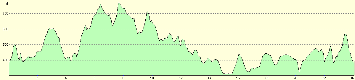
For more information on profiles, ascents and descents, see this page
 |
 |
|
 |
Disclaimer
Please note that I take no responsibility for anything that may happen when following these directions. If you intend to follow this route, then please use the relevant maps and check the route out before you go out. As always when walking, use common sense and you should be fine.
If you find any information on any of these routes that is inaccurate, or you wish to add anything, then please email me.
All images on this site are © of the author. Any reproduction, retransmissions, or republication of all or part of any document found on this site is expressly prohibited, unless the author has explicitly granted its prior written consent to so reproduce, retransmit, or republish the material. All other rights reserved.
Although this site includes links providing convenient direct access to other Internet sites, I do not endorse, approve, certify or make warranties or representations as to the accuracy of the information on these sites.
And finally, enjoy your walking!
Nearby walks
| # | Title | Walk length (miles) |
|---|---|---|
| 75 | Kintbury to Newbury | 9.3 |
| 99 | Newbury to Reading | 19.6 |
| 100 | A circular walk including Inkpen, Walbury Hill and Pilot Hill | 10.4 |
|
|

|