Walk #806: A circular walk from Ringwood
 |
 |
|
General Data
| Date Walked | 30/01/2008 |
| County | Hampshire, Dorset |
| Start Location | Ringwood |
| End Location | Ringwood |
| Start time | 08.15 |
| End time | 16.56 |
| Distance | 23.2 miles |
| Description | This was a pleasant if waterlogged circular walk to the west and southwest of Ringwood. |
| Pack | Today I carried my 30-litre Karrimor rucksack, filled with waterproofs, a book and other odds and ends. |
| Condition | I feel absolutely fine after this walk. |
| Weather | The day was generally bright and sunny, with a few clouds gathering over in the afternoon. There was a little bit of a breeze, but nothing like we suffered on the last walk. |
| OS map | Landranger number 195 (Bournemouth & Purbeck, Wimborne Minster & Ringwood) |
 |
 |
|
 |
 |
|
Map of the walk
Maps courtesy of Google Maps. Route for indicative purposes only, and may have been plotted after the walk. Please let me have comments on what you think of this new format. For a detailed table of timings for this walk, please see the table file.
 |
 |
|
 |
 |
|
Notes
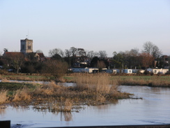
Despite having been in Hampshire for some months, I had not yet done many walks in the New Forest. Studying the map, an obvious route showed itself, a circular walk based on the town of Ringwood. This would be the start of a series of circular walks that would take me westwards, further into Dorset. It was a relatively short drive, and I pulled up in the large long-stay car park in the centre of the town in plenty of time. There had been heavy rain recently, and the ground was fairly wet, but the day looked as though it was going to be bright and sunny.
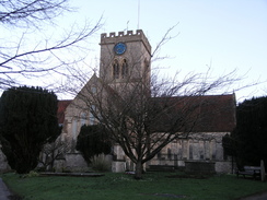
It did not take me long to get my kit together, and I headed off through Ringwood, which I had never visited before. I took a route through the centre of the town. Despite the early hour there was plenty of people about, and I enjoyed the walk through the town, passing people setting out a market stall beside the beautiful church, situated too close to the busy dual carriageway. A little further on there was a plaque on a building, saying that it was the house where the Duke of Monmouth had been held before his execution.
A footpath took me on for a short distance across Bickerley Common that runs alongside the River Avon. This was in flood in places, but this just seemed to make it prettier. Soon I climbed up an embankment, taking me up onto the top of an old railway embankment. This was the start of the Castleman Trailway, a long path that follows the railway line and other paths all the way down to Bournemouth. I was going to be following it for a few miles westwards, and after crossing a couple of bridges over the River Avon the trail took me on under the A31(T).
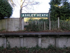
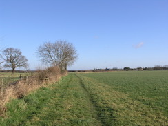
What followed next was a very enjoyable stroll westwards along the old railway line as it passed Ashley Heath, with some lovely views available over the heathland in places. I ambled along rather than walked, enjoying the morning as I listened to a couple of EscapePod episodes. At Ashley Heath the old line crossed a road, and I nipped into an adjacent shop to buy some food.
A little further on along the trail a couple of men were cutting down the surrounding vegetation to clear the path. Again I enjoyed the stroll as it crossed West Moors Plantation. Soon I headed off to the right a little, following the site of some old sidings for the MOD fuel site immediately to the north. This was fenced off by high fences, and the only obvious site aside from that was an MOD sign on a large oil interceptor by the tracks - a large sump designed to stop oil from getting into the adjacent water sources. Adjacent to this was a very large concrete buffer stop, sadly now without tracks.
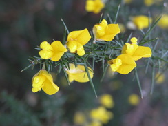
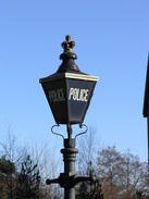
Here the route I was taking left the old railway line, and I had to walk through West Moors for a short distance before continuing on towards Holt Heath nature reserve. Initially it crossed some paddocks, and only just entered the nature reserve to see large banks of yellow gorse before I had to join a track that headed southwards. At a road in Ameysford there were some cyclists stopped, and we chatted for a few minutes about our respective journeys. Opposite us was a larg, modern building - the headquarters of Hampshire police, which had a nice touch of old-fashioned lamp standard with 'police' at the top.
An underpass took me on under the A31(T), and after this roads and footpaths took me on through Fendown, the small section of path being very boggy in places. After crossing a road another path took me southwards along a pleasant stretch of common land. Where the path went further to the east, skirting the edge of the common, I followed a track that headed further to the west. In a couple of places this was flooded, but I really enjoyed the stroll. At Pompey's Corner I angled across towards the proper path, which I met near the A348 road.
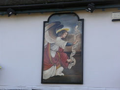
The Angel Pub in Ferndown had an inscription by Chekov written on its exterior wall, along with a very elegant pub sign, and shortly after this another path took me southeastwards towards Dudsbury. Initially this was easy to follow, but there then came a new housing estate that had been built. Around the outside of this there was a new well-built path, and this sucked me in. I emerged on a road well to the east of where I had intended, and I turned right to go down to the B3073.
This headed to a crossing of the A347, and this junction was very busy that took me a long time to cross, both due to the traffic and also because there had been a little shunt that had occurred at the junction. A couple of roads took me on, and then a path headed west. Here I was approaching the southern side of Bournemouth Hurn airport, and a couple of planes came in to land overhead. The path took me near enough to see the western end of the airfield across a road, but I soon was heading past a golf course to pass the colourful rides of the 'Alice in Wonderland Family Park'.
After passing through Merritown another road walk took me on to a bridge over the River Moors in Hurn. I had to cross this carefully as it was narrow, and on the other side a road led across Sopley Common. I wanted to cross this but it was surprisingly busy, so I headed off along a path across the common to the east. This led me up a slight hill, but after a steep bank downhill I had to rejoin the road.
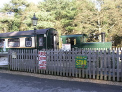
Immediately after crossing the A338 main road there was the Avon Causeway pub on the right, based around a station on an old disused railway line. It had been very sympathetically converted, and there was even a small shunting diesel locomotive and a carriage by the old platform. I went inside for a quick drink and a packet of crisps, before setting off once again.
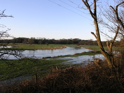
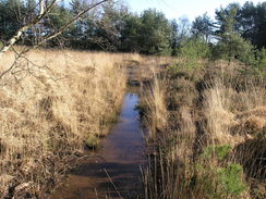
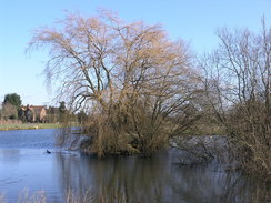
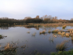
There was little choice except to follow the road across the floodplains of the River Avon to the river itself, and on either side of the road there were signs of localised flooding, large patches of water standing on the floodplain. A bridge led across the river, and a road on the other side took me further eastwards. A series of paths took me northwards from there, passing directly under the flightpath of the airport, allowing me to see a couple of planes coming into land.
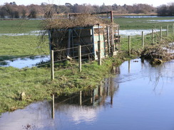
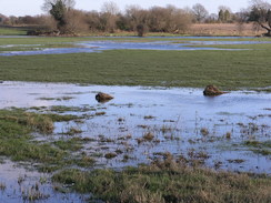
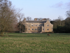
The paths ended at a road that took me past Bisterne Manor on the right and the small Bisterne Church on the right, which is situated literally in the middle of nowhere. After this a series of roads and paths took me northwards, avoiding the main road as much as possible. At one stage the track I was following was completely flooded, but I could divert past this by going into the adjacent field.
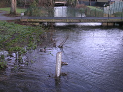
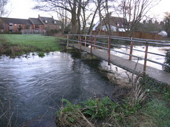
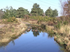
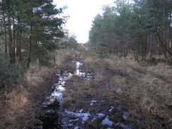
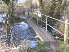
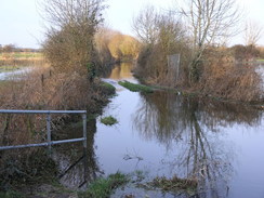
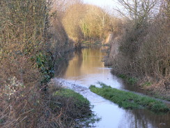
The path passed Kingston North Common, and then headed on northwards to a bridge over a tributary of the River Avon. when I got to the first bridge I was greeted with the sight of a large expanse of floodwater in front of me. I managed to cross the first bridge, which the water was about topping and walk na little further to another bridge. After this, however, the track ahead was covered with flowing floodwaters. Whilst I have been known to wade through floodwaters in the past, this looked too dangerous for my liking, especially as the water was flowing across the path.
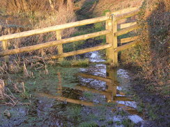
I diverted off along a track for a short distance before joining a footpath that led off to the left. This paralleled the floodwater for a period, but remained dry until I reached a stile. The ground around this had been eroded by feet, and the floodwaters lapped around it. With some difficulty I manged to negotiate around this without getting my feet wet by clambering over the woodwork beside the stile, and I then reached the main road.
This took me back up to Ringwood, and as I walked through the town through the gathering gloom I stopped to take some photographs. My camera started giving me some weird errors, and even taking the batteries out did not stop the problems. It was an annoying distraction as I finished what had proved to be an interesting day's walk.
 |
 |
|
 |
 |
|
Directions
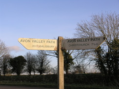
This walk starts off from the long-stay car park in Ringwood. Leave the car park and head south down Furlong Street, following it as it curves to the right to join West Street. Pass the church on the right, and when the road crosses a stream turn left to join the Avon Valley Path. This heads southeastwards across fields for a short distance until a footbridge is reached over the same stream. Cross this, and on the other side turn right to head south across Bickerley Common. A footbridge leads across the stream once more, and on the other side climb up onto a railway viaduct.
Turn right and follow the road westwards for half a mile as it crosses the River Avon and a tributary. When the track ends at a car park and road, turn right and follow the road as it heads immediately under the A31(T). On the other side, take a slip road to the left for a few yards, and then turn left to rejoin the old railway line. This is the eastern end of the Castleman Trailway.
Follow the old railway line and trailway for nearly four miles, as it heads through Ashely Heath and crosses an attractive part of the New Forest. At West Moors the path passes the site of some old MOD railway sidings, and then joins residential roads westwards for a short distance until the B3072 is reached in the village.
Turn right to head north along the B3072 for a couple of hundred yards, and then turn left. This follows the Castleman Trailway westwards along a footpath for half a mile; it crosses some small fields and then skirts the edge of the Holt Heath Nature Reserve before reaching a T-junction with other tracks. Here turn left, to follow the Castleman Trailway southwards for half a mile along a track, passing a golf course on the left before reaching a road in Ameysford. Here the route leaves the Castleman Trailway and joins the Ferndown, Stour and Forest Trail.
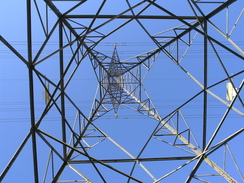
Continue south along a track that immediately passes a police headquarters on the left. Soon the track passes under the A31(T) on an underpass. Continue south along Ameysford Road and take the second road off to the right, Kingsway. Follow this westwards, and when it ends at a T-junction continue straight on along a footpath that squeezes between houses and heads southwestwards for a few hundred yards, paralleling some power lines before turning to the left to join Leeson Drive. Turn right and follow this road southwards until it ends at a T-junction with Wimborne Road.
Cross the road and follow the trail as it heads along a bridleway that heads slightly east of south across some common land; it skirts the eastern end of the common land all the way to the A348 road. I took a route that headed along tracks slightly more to the west to Pompey's Corner; this was an attractive alternative.
When the A348 road is reached turn right to head southwestwards along it for a few hundred yards. Pass a pub in the left, and shortly after the road curves to the left there is a lay-by. From the lay-by a footpath leads off to the left to head east above Holmwood Park, before entering Belle Vue Plantation. There were new houses here that were not marked on my map, and my route down to meet the B3073 road on Dudsbury Hill was much different from the official trail.
When on the B3073 turn left to start following it eastwards. After half a mile the A347 road is reached; carefully cross this road and continue on eastwards along the B3073 for a third of a mile. When a pub is reached on the left, turn right down a road for a little over half a mile southwards. Before the end of the road is reached turn left along a footpath that initially follows a track, heading eastwards across fields for two-thirds of a mile to Parley Court. Here join a track that heads eastwards to Parley Green, before curving around a golf course and passing immediately to the south of the 'Alice in Wonderland Family Park' and reaching Merritown.
Immediately after the park the track becomes more enclosed as it continues on eastwards to end at a road in West Hurn. Turn right to follow the road for a third of a mile as it heads southeastwards and then southwards. When a road junction is reached on the left, turn left to head eastwards along the road for half a mile, when the road curves to the left to head northwards for under half a mile until the road ends at the B3073. Turn right along the B3073 road to a bridge over the Moors River; on the other side of the bridge the road curves to the right.
Here turn left to start heading northeastwards along the Avon Causeway as it crosses Sopley Common. After a mile the A338 is crossed on a bridge, and on the other side there is a pub on the left. Carefully continue along the winding road eastwards for a mile from the bridge as it crosses floodplains to reach a bridge over the River Avon, and immediately beyond this the B3347 road. Cross the road, pass Court Farm on the right and continue eastwards along the road for under half a mile. When a footpath carrying the Avon Valley path heads off to the left, follow it as it heads northwards across fields. It soon squeezes between two sets of trees, and after half a mile reaches another road.
Cross this road and continue on northwards for a little over half a mile; it crosses another road (Anna Lane)before entering some trees and ending at the B3347 road. Turn right and start following this road as it heads northwards for a little under a mile. Opposite Bisterne church a footpath leads off to the left. Follow this footpath as it crosses fields for half a mile, curving to head northwestwards and ending at a road. Turn right and follow this road northeastwards; when it curves to the right turn left along a track that leads through Kingston to reach the B3347 road once again.
Turn left and follow the road northwards for a few yards before turning to the left down a footpath that heads northwards for a mile across Kingston North Common, until a footbridge across a stream of the River Avon is reached. The Avon Valley Path can be followed northwards all the way back to Ringwood, but due to impassable flooding I turned to right to follow a track eastwards. After a hundred yards a footpath urns off to the left, heading northeastwards for a third of a mile until it ends at the B3347 road. Turn left to start following this road northwards for a little under a mile into Ringwood, crossing a roundabout on the way. This road can be followed all of the way back to the car park; instead, near the end I turned left down The Close and headed across to the car park from there.
 |
 |
|
 |
 |
|
Distances
| From | To | Distance (m) | Ascent (ft) | Descent (ft) |
|---|---|---|---|---|
| Ringwood | Ashley Heath | 3.1 | 75 | 66 |
| Ashley Heath | Ferndown | 4.5 | 46 | 49 |
| Ferndown | A338 | 8.4 | 187 | 223 |
| A338 | Ringwood | 7.2 | 92 | 62 |
This makes a total distance of 23.2 miles, with 400 feet of ascent and 400 feet of descent.
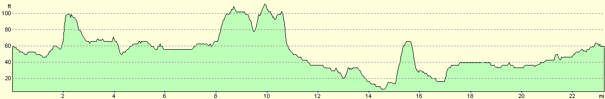
For more information on profiles, ascents and descents, see this page
 |
 |
|
 |
 |
|
 |
 |
|
 |
 |
|
 |
 |
|
Disclaimer
Please note that I take no responsibility for anything that may happen when following these directions. If you intend to follow this route, then please use the relevant maps and check the route out before you go out. As always when walking, use common sense and you should be fine.
If you find any information on any of these routes that is inaccurate, or you wish to add anything, then please email me.
All images on this site are © of the author. Any reproduction, retransmissions, or republication of all or part of any document found on this site is expressly prohibited, unless the author has explicitly granted its prior written consent to so reproduce, retransmit, or republish the material. All other rights reserved.
Although this site includes links providing convenient direct access to other Internet sites, I do not endorse, approve, certify or make warranties or representations as to the accuracy of the information on these sites.
And finally, enjoy your walking!
Nearby walks
| # | Title | Walk length (miles) |
|---|---|---|
| 311 | Milford on Sea to Southbourne | 16.9 |
| 312 | Southbourne to Hamworthy Station | 15.3 |
| 801 | A circular walk from Brockenhurst to Burley | 23.5 |
|
|

|