Walk #805: A circular walk from Worth Matrevers to Kimmeridge
 |
 |
|
General Data
| Date Walked | 27/01/2008 |
| County | Dorset |
| Start Location | Worth Matravers |
| End Location | Worth Matravers |
| Start time | 08.39 |
| End time | 16.07 |
| Distance | 16.0 miles |
| Description | This was a pleasant walk following the South West Coast Path westwards from Worth Matravers towards Kimmeridge, before coming back along the ridge leading to Swyre Head. |
| Pack | Today I carried my 30-litre Karrimor rucksack, filled with waterproofs, a book and other odds and ends. |
| Condition | My left knee aches slightly after this walk, a sign of the injury that I suffered on the last walk. |
| Weather | The weather today was bright and sunny, with no clouds in the sky. There was a very brisk chilling wind that was piercing when exposed to it in the morning. |
| OS map | Landranger number 195 (Bournemouth & Purbeck, Wimborne Minster & Ringwood) |
 |
 |
|
 |
 |
|
Map of the walk
Maps courtesy of Google Maps. Route for indicative purposes only, and may have been plotted after the walk. Please let me have comments on what you think of this new format. For a detailed table of timings for this walk, please see the table file.
 |
 |
|
 |
 |
|
Notes
It had been a couple of weeks since our last walk along the South West Coast Path, and we were both keen to do another stretch. I therefore set off for the long drive to Worth Matravers. I had injured my knee in a small slip at the end of the last walk, and although I believed that it had healed well I was slightly concerned about it. Since then Sencan had bought herself a couple of walking poles, which meant that we both had a set. She had also bought some gaiters after the fairly thick mud we had encountered on the last stretch of the path.
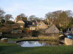
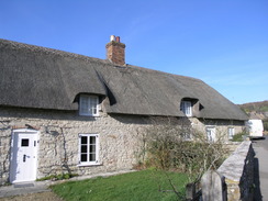
We soon pulled up into the car park at Worth Matravers, which was nearly empty. It cost a pound to park, and I put a coin into the honesty box before getting ready for the walk ahead. We put our boots and gaiters on, and were soon striding off once more. We passed through the pretty village to reach the point where I had slipped; I looked in vain for the mark that my boot had left, but it had been obliterated by the joint action of both walkers' feet and cattles' hooves.
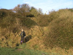
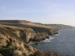
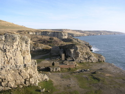
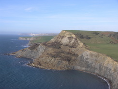
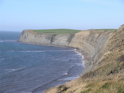
The little valley of Seacombe Bottom was as pretty as it had been on the previous walk, and we soon reached the quarry that faces onto the sea. This is a fascinating little place, but as we walked through it I soon realised I had gone wrong; the path follows the cliffs above it. We headed back, and found the steps that led up onto the cliffs. A pleasant walk followed to Winspit Quarry, and I enjoyed looking at the ruined buildings before we started the long climb up to St Aldhelm's Head. Here we were exposed to the wind for the first time during the day, and it was very strong, blowing us about one way and then the other.
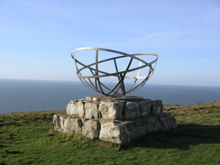
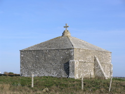
St Aldhelm's Chapel is a low stone building, a Norman construction whose rugged construction seems fitting for the exposed location. A short distance away was a monument to the radar station that had been built here - and subsequently bombed - in the Second World War. Sencan is a RF engineer, and so the people who worked here were, in some respects, her predecessors.
The wind on the next stretch was particularly fierce as we passed a coastguard station on the high cliffs. Next came something that I remembered from my previous walk with dread - as steep descent into a valley and an equally steep climb up on the other side. When I had walked this stretch five years before it was getting dark and I had run out of energy after a long and tiring winter's walk. This time, early on in the day, it did not seem as bad, although the steps on either side did not really suit my stride length. It was a relief when we reached the cliff top on the other side.
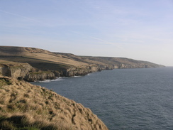
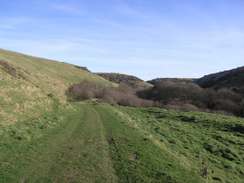
There were good views from the cliff top on West Hill, and I was surprised that I could even make out the Isle of Portland in the distance to the west. On the cliff top there was a peasant little memorial, but I was too busy trying to remain standing in the wind. The path descended down a steep slope to some houses at Hill Bottom, and we paused here for a while before heading along a pleasant walk along a track. This slowly climbed as it headed back towards the coast, the path having missed out Chapman's Pool, where cliff falls have caused the old route to be closed.
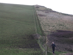
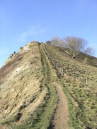
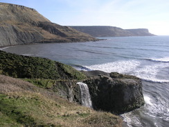
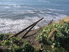
The next climb was up Hans Tout Cliff, a steep, stepped climb that took some time. It was really steep, but by plodding slowly we managed to reach the top; as we climbed I counted the steps - there were 165. The path is level at the top of Hans Tout for a very short distance before it drops down, although not as steeply as the ascent had been. At one point there were fence posts and wire sticking out of the cliffs from a previous cliff slump. At Freshwater Steps there is a waterfall where a man-made channel drops down to the sea, but we did not stop to look at this for too long as we had to continue on.
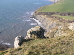
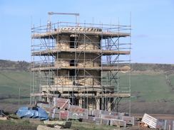
A series of small rises and falls followed, nothing too steep compared to those we had already undertaken, but ones that added strains to tiring legs. There were some good views to be had, and at one point there was a set of narrow-gauge rails, part of some point work, sticking out of the cliffs. It was a strange sight, and I could not see any obvious sign of where they had come from. Eventually we reached Hen Cliff and the Clavell Tower.
This stone folly was in the progress of being moved away from the cliffs due to the danger from erosion, and the whole area around it was one large work site. It had been dismantled stone by stone, and was now being re-erected in its new location. The stones were being stored in large wooden crates that had 'Property of Kodak' stenciled onto them. I wondered if representatives of that company were going to claim their crates back.
Out to sea were many surfers, looking like small black seals in the distance. The moving of the tower further inland led me to postulate a 'theory of coastal deposition', the only evidence of which was the fact that the tower had been nearer the sea when I had last walked past; hence, the cliffs must have been deposited over the last five years.
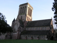
We headed downhill from the tower, passing a boggy stretch to reach the car park at Gaulter Gap. It seemed as good a place as any for a rest, so we sat down on one of the logs delimiting the car park and ate our sandwiches. Neither of us wanted to head back along the coast, so when were were ready we followed the road that led from the car park to the attractive little village of Kimmeridge. From the tiny church we headed uphill via another footpath, avoiding a winding stretch of road.
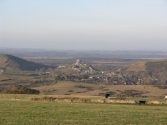
From a road junction a path took us up the western side of Smedmore Hill, and what followed was a very pleasant ridge walk with some good views out over the sea to the southwest. There were some paragliders packing up on the other side of the hedge, and we chatted as we strolled along. Where we had been feeling tired at Kimmeridge, we both seemed to have recovered on this relatively high and level stretch.
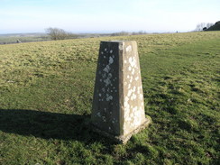
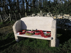
I stopped to photograph the trig pillar at Swyre Head, and started following another path that skirted the top of a cliff inland. Just before this met a road there was a memorial bench, commemorating the people who died in two plane crashes on these cliffs. For more infromation on these crashes, see the OPC website. A long road walk followed, leading us down to the village of Kingston. From here we had several routes that we could have taken, but we decided to take a road route, which headed eastwards. At Kingston Barn there was a large pile of stone in a field.
Just before we reached the car park at Worth Matravers we passed Compact Farm, which had a strange term, 'Balbithan Charolais' written on the sign. This turns out to be a type of cow that is bred at the farm; it sounded more like a French place name to me.
By the time we reached the car we were both tired but felt happy at what had been a fairly spectacular day's walk around the coast and the Purbeck Hills. The next walk will take us west across the army ranges at Lulworth, which promises to be a very strenuous walk.
 |
 |
|
 |
 |
|
Directions
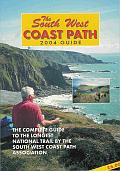
| During this walk I followed the South West Coast Path, the route of which is detailed in the Ordnance Survey National Trail Guide 11, Exmouth to Poole (ISBN 1-854109-88-X). Unfortunately the route description is written in reverse to the direction that I am walking, but the 1:25,000 maps in the book are clear and the signs on the ground are very good. Also to be recommended is the South West Coast Path Association guidebook (ISBN 0-907055-04-4), which has less concise directions and no maps but does include accommodation details and grades each section of the walk according to difficulty. They also publish reverse directions, which are suitable for walking in the direction that I walked the route. They have a website at www.swcp.org.uk, which is well worth a visit. | 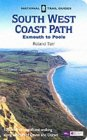
|
| 
| |
| |
| |
There are two exceptions to this at the start and end of the walk. For the first part of the walk to the South West Coast Path heads eastwards along a footpath that climbs and falls before finally descending down to Seacombe Bottom. Just before the sea is reached at a quarry, turn right along some steps to join the path.
From Kimmeridge Bay, follow the road that heads northeastwards from the bay into the village of Kimmeridge. When the road curves sharply to the right head straight on along a footpath that passes to the right of the small church before climbing steeply uphill. The path ends at a road junction; here head eastwards along a road for a few yards before turning right along a bridleway that climbs uphill. This is easy to follow as it climbs up onto Smedmore Hill, and continues on for a mile and a half from the road to Swyre Head. All the way keep the hedge on the right.
From Swyre Head turn sharp-left to head northeastwards along the top of a ridge, which slowly descends past Polar Wood before reaching a car park beside a road. Here turn right and follow the road eastwards for a mile to Kingston village. Pass the church in the village and continue on along the B3069 road eastwards for a mile, passing Kingston Barn to a road junction. Turn right down this road, and follow it southwards for a mile until the car park is reached in Worth Matravers, where this walk started.
 |
 |
|
 |
 |
|
Distances
| From | To | Distance (m) | Ascent (ft) | Descent (ft) |
|---|---|---|---|---|
| Worth Matravers | Kimmeridge Bay | 9.6 | 2585 | 2988 |
| Kimmeridge Bay | Kingston | 4.4 | 876 | 515 |
| ingston | Worth Matravers | 2.0 | 177 | 135 |
This makes a total distance of 16.0 miles, with 3638 feet of ascent and 3638 feet of descent.
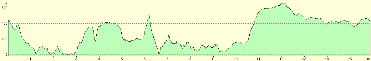
For more information on profiles, ascents and descents, see this page
 |
 |
|
 |
 |
|
 |
 |
|
Disclaimer
Please note that I take no responsibility for anything that may happen when following these directions. If you intend to follow this route, then please use the relevant maps and check the route out before you go out. As always when walking, use common sense and you should be fine.
If you find any information on any of these routes that is inaccurate, or you wish to add anything, then please email me.
All images on this site are © of the author. Any reproduction, retransmissions, or republication of all or part of any document found on this site is expressly prohibited, unless the author has explicitly granted its prior written consent to so reproduce, retransmit, or republish the material. All other rights reserved.
Although this site includes links providing convenient direct access to other Internet sites, I do not endorse, approve, certify or make warranties or representations as to the accuracy of the information on these sites.
And finally, enjoy your walking!
Nearby walks
| # | Title | Walk length (miles) |
|---|---|---|
| 313 | Hamworthy Station to South Haven Point | 18.0 |
| 314 | South Haven Point to Worth Matravers | 16.7 |
| 315 | Worth Matravers to Lulworth Cove | 12.7 |
|
|

|