Walk #949: Stour Valley Path: Stoke-by-Clare to Sudbury
 |
 |
|
General Data
| Date Walked | 22/05/2012 |
| County | Suffolk, Essex |
| Start Location | Stoke-by-Clare |
| End Location | Sudbury station |
| Start time | 08.28 |
| End time | 15.54 |
| Distance | 18.4 miles |
| Description | This walk follows the Stour Valley Path as it roughly follows the Stour Valley east and then south. |
| Pack | Today I carried my 30-litre Karrimor rucksack, filled with water, my waterproofs, a book and other odds and ends. |
| Condition | I feel relatively okay after this walk. |
| Weather | Today started off with a certain amount of cloud, with some sunny periods. As the day progressed the skies slowly cleared, leaving a rather warm day for walking. |
| OS map | Landranger number 155 (Bury St Edmunds, Sudbury & Stowmarket) |
 |
 |
|
Map of the walk
Maps courtesy of Google Maps. Route for indicative purposes only, and may have been plotted after the walk. Please let me have comments on what you think of this new format. For a detailed table of timings for this walk, please see the table file.
 |
 |
|
Notes
As today's weather forecast was for good weather, I decided to take another day off decorating our new house and go for another walk. My last walk had been along the Stour Valley Path to Stoke-by-Clare, and it seemed a good idea to continue this trail by walking between Stoke-by-Clare and Sudbury, using a bus to get back to the starting point. However as there were more busses in the morning than the afternoon it seemed sensible to drive a little further to Sudbury, park there and get the bus to the start point in the morning.
A leisurely morning drive took me to Sudbury, although I was disappointed by the overcast skies instead of the forecast bright sunshine. I parked at the station car park and got my kit together before strolling over to the bus station. The drive had been timed more or less perfectly and there was ten minutes to wait for the bus; I nipped into the toilets before joining a long stream off schoolchildren waiting alongside three older women. I was surprised to find the bus was a double-decker, but the reason soon became obvious when the schoolchildren all crowded on.
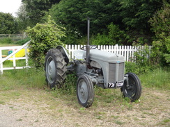
The bus journey as far as Clare was a noisy affair as more children got on at each of the stops. They were well-behaved except for the cacophony that rose up from them. It was a relief when they all got off at their school in Clare, and the kids who got on at the next stop were thankfully much quieter. I got off outside the Red Lion in Stoke-by-Clare and nipped into the adjacent community shop to buy a few provisions. An immaculate old Fergie tractor was parked in the car park and I took a few photographs of it before heading off on the trail.
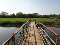
The map showed the trail leaving the village along a pavementless stretch of main road. I was not looking forward to that, and it was a relief when I found a footpath sign pointing away from the green. This diversion followed the old railway line, and passed what looked like an old station building in the process. The new route passed a paddock filled with sheep and new-born lambs before reaching a bridge over the River Stour.
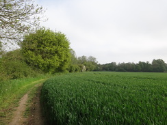
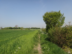
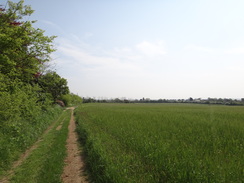
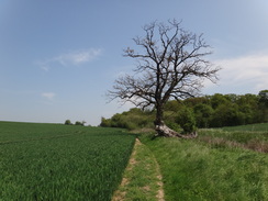
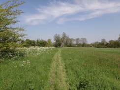
Sadly the trail did not stay with its eponymous river, and instead headed uphill across fields. The route was easy to follow as the farmer had kindly kept the line free of crops. I stopped for a while to watch a couple of horseriders walking beside the river below; there was no path on the map, but they certainly seemed to know where they were going.
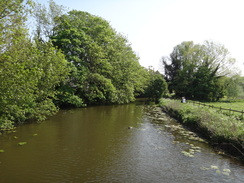
The path led to a road, after which a fairly boring stretch of path continued on past a farm to reach another road. This was slightly larger, and was followed downhill before another path led off to rejoin the river bank once more. In one place this went through the well-kept garden of an adjacent house before breaking out beside the river. By now the sun was coming out and this stretch of river looked particularly splendid. Soon a road was reached, and a riverside path led me past the site of a priory and beside the embankment of the old railway line before reaching a car park in Clare.
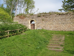
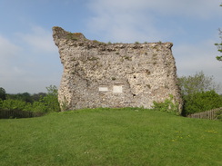
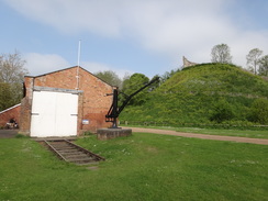
I have visited Clare on several different locations, and think it is a marvellous little village. Even the area around the car park is pleasant, with a large castle motte dominating the views. I could not resist walking up the long spiral path that leads to the top. The remains of a flint-filled curtain wall heads directly up the mound, whilst a small section of the castle's tower remained at the top. Sadly the surrounding vegetation blocked most of the views, but the old railway station site below was clearly visible. The old goods shed is now a visitor's centre, although the station building was boarded up.
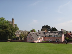
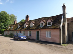
The trail does not visit the centre of Clare, which is a shame as the village is really rather pretty. Instead it crossed the main road and headed north, passing some playing fields and the police station before following fields. What followed was a pleasant stretch of path that climbed uphill and skirted the farm at Houghton Hall before descending down into Cavendish. This is a superbly picturesque little village, with lots of buildings decorated in different colours, including three pink cottages clustered in front of the church.
By now the sun was well and truly out, so I decided to stop early to eat the sandwiches that Sencan had made for me this morning. I sat on a bench on the village green beside the war memorial that offered a splendid view down the high street. I could have stopped there all day, but after munching my sandwiches I reluctantly stuffed my fleece into my rucksack and headed off.
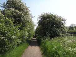
The trail follows the main road out of the village before taking a path to the north. This soon climbed up a slight hill and continued across fields to reach the village of Glemsford, entering via an overgrown path that was nearly blocked by impenetrable vegetation. The trail scarcely entered the village before leaving it once again, skirting behind gardens and then striking across fields. A young couple beside the River Glem were a picture of love - they were holding hands and striding along with broad smiles.
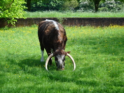
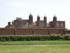
A rickety footbridge took me across the Glem before climbing up the side of a little valley that sadly offered little in terms of view, but also little in terms of exertion. It was an easy climb, and soon I passed some woodland to meet a junction of tracks. One of these took me past the Tudor-era Kentwall Hall, which remained stubbornly out of view behind trees until I reached the main gates, which were guarded by some cows with lethal-looking curved horns. Two brick gatehouses flanked either side of the gates, and one of these housed the entrance booth to the hall. Of more immediate interest to me was a sign for ice cream, and I nipped in to buy one before heading off down the driveway.
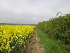
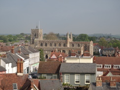
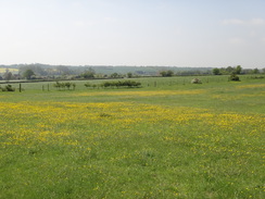
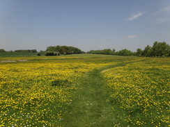
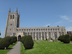
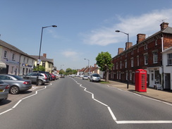
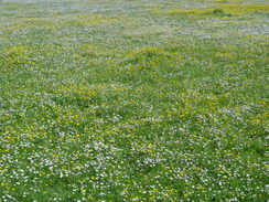
The trail does not follow the driveway all the way down into Long Melford, and instead cuts off towards the church. I took the wrong turn and floundered around for a few minutes before finding the correct route which crossed a spectacular green, yellow and white carpet of daises and buttercups. A short stroll further on took me to Long Melford church, which is rightly famed as a classic 'Wool Church', built as a result of the area's medieval wealth from the wool trade. Although I have visited the village many times I have never been into the church, and today was no exception. I passed a large group of ramblers heading in the other direction beside the Trinity Hospital, established in 1573 and still in use for its original purpose.
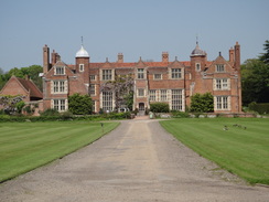
I stopped outside a house to have a chat with a woman who was unloading her car - her love for the area was obvious and she waxed lyrically about her adopted village. Off to the left was another stately home - Melford Hall, which is famed as a place that Beatrix Potter frequently visited. Not many villages can claim two stately homes, a Grade-I listed hospital and a spectacular church, but that was just the start for the village itself is superb, with many attractive buildings on either side of the wide main road.
By now I was in need of some shelter of the sun, so I nipped into a pub that turned out to be slightly posher than I was used to. The staff did not seem to mind, and I studied the menu before deciding not to try any of their food, which seemed overly rich for a warm day's walk. Instead I gulped down a couple of pints of bitter shandy whilst I studied some of the glossy magazines they kept on the windowsill. More customer came in as I glanced at some very expensive Suffolk houses that were for sale, although all chose to eat out in the garden, leaving me more or less on my own.
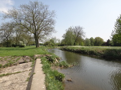
Eventually I set of once again. The trail did not follow the main road for long before diverting off across the floodplain. Soon the Stour was met once again - it had gained a few feet in width, and for the first time it really felt like a river. The trail continued on, joining a road for a period towards Rod Bridge. An old railway bridge came into view on the left, and I was surprised to see that this now houses a cycle path that is not marked on my map - presumably a safe and quiet route back into Long Melford.
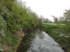
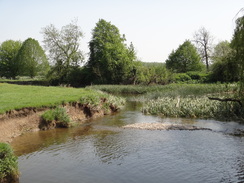
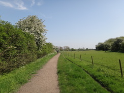
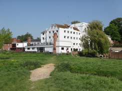
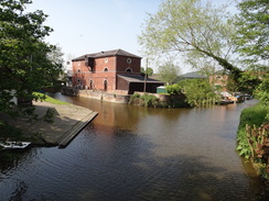
The trail followed the old railway trackbed southwards. This was very popular with walkers, many of whom were wearing shorts in the glorious weather. The cycle path continued along the trackbed whilst the trail headed off across the floodplain to rejoin the bank of the Stour. Some of the views were very pleasant, and it felt good for the trail to be back in the company of the river from which it gets its name. It passed a hotel converted from an old mill before crossing a footbridge across a tributary of the river to reach the A131 road in Ballingdon.
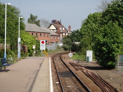
Here I decided to leave the trail, and instead climbed up the embankment to rejoin the old railway line. This took me across a bridge over the river, with some wharves visible through the trees, and on until the route was blocked by a leisure centre in Sudbury. A quick diversion around this led me to the railway station and my car. It had been a surprisingly enjoyable walk; although the scenery was not classically beautiful, some of the villages were exemplary. In addition the display of wild flowers, and especially the daisies and buttercups, added another dimension to the day.
 |
 |
|
Directions
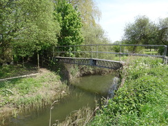
This walk starts off outside the Red Lion pub in Stoke-by-Clare. Leave the pub and turn left to walk northeastwards along the A1017 road, towards Clare. Shortly after the village green is reached on the left, turn right down a narrow footpath that runs between hedges along the course of an old railway line - this is a diversion off the route on the map, and is much safer than following the pavementless main road. Soon the houses are left behind and the path follows the edge of a field with a hedge on the left. At the bottom of the field squeeze through a hedge and then turn right to pass some smallholding fields on the left. The path curves right and then left to reach a gate; go through this to reach a bridge over the River Stour beside a weir at TL747436.
Cross the bridge, and on the other side turn half-left to head in a rough easterly direction, soon reaching a little bridge over a ditch. Continue in the same direction as the path climbs; at the top it passes the end of a hedge on the left and heads across another field to reach the corner of a hedge. Go through the hedge and follow a hedge on the left, which emerges out through a gap in the hedge onto Ashen Road. Turn left to head down the road for about fifty yards, and just after a clump of trees turn right across a stile to access another footpath at TL758438.
The path follows a green track between fields; it passes a small plantation on the left and curves to the left to head eastwards. The path then curves to the left and then right to head eastwards along a green track between a hedge on the left and a fence on the right. The track becomes firmer and curves slightly to the left to approach a wood; it enters the trees and then curves to the right and then left to pass in front of Claret Hall. Continue along the access driveway to reach Bradley Hill at TL767438.
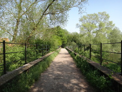
Turn left to follow the road as it heads downhill; after a quarter of a mile it ends at a T-junction with Ashen Road. Turn right along the road and carefully look for a path leading off to the left. It goes down a short driveway and through a low gate to enter a garden. At the bottom of the garden turn right through a gate to follow a footpath through a series of gardens guarded by fences, with the river on the left. It soon emerges through a gate into a field; follow the hedge and river on the left until a road is reached, with a bridge over the river on the left. Turn left along the road for a few yards towards (but not over) the bridge, then right along a good riverside path. Soon it turns right and then left to rejoin the old railway trackbed; it crosses the river on a bridge before emerging out into the car park in Clare Castle Country Park at TL770451.
Turn half-left to head diagonally through the car park. Pass the old goods shed on the right and the motte of Clare Castle on the left, which is well worth a climb. Continue along the good track as it passes the old station building on the right before crossing a footbridge over a stream. Immediately after crossing the footbridge turn left to take a path that runs between hedges. When the path forks, take the right-hand branch that soon curves to the left to pass a little graveyard to reach the A1092 road.
Carefully cross the road and turn right to follow it eastwards for about twenty yards, before turning left up a track that passes some playing fields on the left. Pass to the right of a building and continue on as the track becomes rougher. It passes another building and then curves to the left; at this bend continue straight on along a path through trees before emerging out onto the edge of a field. Keep the hedge on the left as the path heads northwards; when the corner of a field is reached at TL775463, turn right to head up a slight slope, still following a hedge on the left.
Squeeze through the hedge in the top-left hand corner of the field, then turn left to follow a hedge on the left. The hedge soon curves to the right; when it curves to the left shortly afterwards, continue straight on along a path between two fields. The path descends slightly; at the bottom go through a wide gap in a hedge before climbing slightly whilst following a hedge on the left. Soon it passes Houghton Hall on the right.
When the hedge ends at the hall, pass the complex of buildings on the right; the hedge soon restarts on the right. After a short distance the path goes through the hedge and continues with the hedge on the left. At the bottom of this field turn right to start following a hedge on the left; after a short distance turn left through the hedge and cross a footbridge over a stream. On the other side immediately turn right through a gap in a hedge, then turn left to start following this hedge uphill east-northeastwards. It squeezes past a garden before ending at a road at TL796468.
Turn right to start following the road southwards, immediately passing a house on the right. The road curves to the left and then the right, and finally the left once more. After a third of a mile turn right down a path that heads between two fields. At the far corner of the field, turn left through a gap in the hedge to enter a small field. Keep the hedge on the left; it soon curves to the right to reach another corner of the field. Here turn left through the hedge and follow a path as it passes through a graveyard. Leave the graveyard via a stile and follow a track that ends at Peacocks Road in the village of Cavendish. Turn right down this road for a short distance until it ends at a T-junction with the A1092 road at TL805464.
Turn left to start following the A1092 road eastwards through the village. After a third of a mile the B1064 road comes in from the right; here turn left along a path that heads north between two low brick walls. The wall on the right soon ends and the path emerges onto a playing field. Walk across the middle of the field, aiming for a gap in a hedge ahead. Go through the gap to enter a field; head two-thirds of the way across the field until a path is reached. Here turn right to head eastwards to the edge of the field. Go through a gap in the broad hedge ahead and then turn right to follow the hedge on the right.
After about fifty yards, turn left along a path that runs across the middle of the field. The path climbs slightly and goes through a gap in a hedge; continue straight on across the middle of a second field downhill to reach a hedge. Go down some steps and then cross a footbridge over a stream to reach a stile. Cross this and head on, following a fence on the right. At the top of the field cross two stiles through a single hedge to enter another field. Follow a hedge and fence on the right; when this reaches another corner, turn left to follow a hedge on the right for about thirty yards to reach a stile on the right.
Cross this into another field; head straight across this field to pass the end of a hedge on the right. Turn slightly to the left across this field to reach the corner of a hedge ahead. At the hedge head straight on, following a rough track with the hedge on the left. After passing a house on the left the track becomes firmer and curves to the left to head northwards. Opposite a house, turn right down a path following a hedge on the left. At the corner of the field turn left through the hedge, then right down a narrow path that runs between hedges, becoming a driveway that ends at the B1065 road in Cavendish near the Cock Inn at TL828474.
Turn left to head north up the road and then take the first road to the right, Flax Lane. As the lane curves to the right, turn left along a path that runs between hedges, initially with a house on the left. Follow this path north for nearly three hundred yards as it passes houses on the left until a crossroads with another path is reached; here turn right across a bridge over a ditch and follow a hedge on the right eastwards. After a third of a mile the path ends at Park Lane in Glemsford at TL835477.
Turn left to head north along Park Lane for a short distance, before turning right through a gap in a hedge. Follow a footpath with a hedge on the left; it goes through a hedge at the end of this field and continues on. The hedge curves to the left to reach a second hedge. Go through a gap in this and continue following the hedge downhill across a third field. At the bottom turn right to start following a ditch on the left southeastwards. After a quarter of a mile turn left through a gap in the hedge and cross a plank bridge over the ditch. Head on northeastwards across the centre of a small field to reach a footbridge over the River Glem. Cross this; on the other side follow the path between fences and hedges. The path becomes a driveway that passes between two houses before it ends at the B1066 at TL848479.
Turn right to follow the road south-southeastwards for 250 yards. Just before some barns are reached on the left, turn left along a footpath that follows a low hedge on the left. This crosses a concrete plinth and heads behind some barns and storage cylinders. Join a track that curves to the right and then left to head northeastwards away from the barns. After a while angle left off the track for a short distance to join a ditch on the left, and follow this to reach the corner of the field.
Cross a bridge over a stream to enter another field, then turn half-right to head diagonally across the corner of a field to reach a ditch on the other side. Turn left and start heading uphill, keeping the ditch on the right. An area of woodland starts on the right; at the top of the field the path goes through a gap in a hedge and continues following the treeline. The woodland swings to the right to take a more easterly course and the path becomes a rough track that ends at a crossroads in tracks at TL860485. Turn right to head south down a track, initially with the woodland on the right.
After a while a track curves off to the right as the main one curves to the left; go through a stile in the middle of the two tracks and continue on, keeping a hedge on the right. When this meets a track turn left down the track; go through a field gate and continue on as the track enters a patch of woodland. Go through a second gate to join the hall's main driveway just south of the gatehouses at TL864477.
Turn right and go through a gate to start following the driveway south-southeastwards away from the hall. After a third of a mile at TL865472, turn right to cross a stile over a fence beside a field gate and head south-southwestwards across a field, with a fence some distance away to the right. Aim to the right of the church tower; the path then curves to the left to head towards the tower. Cross a stile at the end of the field to enter a band of trees, then cross another stile to reach a paddock.
The path immediately forks; take the right-hand branch to reach another stile at the end of the field. Cross this to reach a green track that runs between paddocks. Turn left to follow this eastwards directly towards the church tower. After thirty yards cross a stile and turn half-left. Go through a gate to enter the churchyard, then right to skirt past the church tower on the left. After this head diagonally along a path across the churchyard to reach the main gateway.
Turn half-right to start following Church Walk south, passing the brick buildings of the Holy Trinity Hospital on the left. When this road ends at a junction with the A1092, carefully cross the road and continue south down a minor road, passing houses on the right and a green on the left. This road ends at a junction with the B1094; continue straight on along the B1094 for half a mile through Long Melford.
Just after passing the George and Dragon pub on the left, turn right at TL862453 down a narrow surfaced path that runs between buildings, with the library on the right. Follow this path as it curves to the right between fences. It crosses the end of a road and emerges out onto the corner of a playing field. Head straight on, following a hedge on the left with the playing fields on the right. When the playing fields end, squeeze past barriers through a hedge ahead to enter a rough field. Follow a hedge on the left as it curves to the left to take a southwesterly course.
As the hedge curves away to the left, head straight on southwestwards across the floodplain towards a bend in the river. Go through a clapper gate beside a field gate and continue towards the river. Cross the end of a dry ditch that drains into the river, and then turn right to continue following the river on the right. The path crosses a couple of footbridges over sluices before emerging out through a clapper gate onto Liston Lane at TL856449. Turn right along the road for a few yards, then left along a driveway leading to a house. After a few yards turn left down a footpath, passing a garden on the right. Cross a stile into a field, and then follow a hedge on the left. At the corner of the field turn left to reach a second stile. Cross this and turn right to follow a hedge on the right. At the end of the field cross a third stile and follow a hedge on the left. This then joins a driveway that passes a garden on the right and ends at a road at TL852443.
Follow this road as it heads south, passing Place Farm on the left. After a quarter of a mile it ends at a T-junction with the B1064 road. Turn left to continue southeastwards for another third of a mile, after which the road swings to the left. Shortly after a road junction on the right, and before a bridge over the river is reached, turn right down a cycle path called the 'Valley Trail' that runs along an old railway line. Follow this for nearly a mile until just after it crosses a stream at TL861423.
Shortly after the bridge the track forks. Take the left-hand branch which descends off the railway embankment and follows a hedge on the left. Go through a field gate and join a surfaced lane that curves to the left to reach Brundon Mill. Just before the mill is reached turn right down a track that passes some mill cottages on the right. Skirt to the right of a gateway with the river to the right and a garden wall on the left. The path reaches a clapper gate and continues on with the wall on the left. Soon after the gate the path continues between fences and emerges onto the floodplain. Go through a pedestrian gate to reach a footbridge over a stream; cross this and go through a clapper gate on the other side.
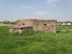
Head southeastwards across the floodplain, aiming for a pillbox ahead. Shortly after the pillbox go through a clapper gate and cross a footbridge over a weir at the end of the field. On the other side go through another clapper gate and continue on with the river on the left; it passes a footbridge over the river (do not cross) and passes a little park on the right. Follow the river until the Mill Hotel is reached on the right.
Here the path turns slightly to the right beside the river; when the river curves away to the left, continue straight on to reach a footbridge over a water-filled ditch. Cross this and continue on to a larger footbridge over another stream of the river; there are gates on either side of the bridge. On the other side turn left to start following the river downstream on the left; it slowly angles away from the river and reaches a clapper gate that leads onto the end of a track. This immediately crosses a bridge over a stream; follow this track for a short distance until the A131 is reached at TL866408.
Here the Stour Valley Path is left behind. Just before the main road, turn right to climb a slope that leads onto the top of the old railway embankment. At the top, turn left and follow the path at the top as it crosses the A131 on a bridge. Keep on this for two-thirds of a mile as it crosses two large bridges; the first over the river bridge, the second over a large stream. When the path ends by a leisure centre, turn left and walk through the car park to reach the centre's entrance. Turn left and then right, still skirting the centre, to reach a road. Turn right down this road for a short distance to reach Sudbury railway station at TL876410, where this walk ends.
 |
 |
|
Distances
| From | To | Distance (m) | Ascent (ft) | Descent (ft) |
|---|---|---|---|---|
| Stoke-by-Clare | Clare | 3.0 | 118 | 157 |
| Clare | Glemsford | 5.5 | 420 | 335 |
| Glemsford | Long Melford | 4.7 | 203 | 318 |
| LOng Melford | Sidbury station | 5.2 | 69 | 95 |
This makes a total distance of 18.4 miles, with 810 feet of ascent and 905 feet of descent.
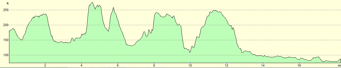
For more information on profiles, ascents and descents, see this page
 |
 |
|
Transport
Beeston's route 236 runs nine times a day between Sudbury and Stoke-by-Clare. For more information, see the Travelline website.
 |
 |
|
 |
 |
|
 |
 |
|
 |
 |
|
 |
 |
|
 |
 |
|
 |
 |
|
 |
 |
|
 |
 |
|
 |
 |
|
 |
 |
|
 |
 |
|
Disclaimer
Please note that I take no responsibility for anything that may happen when following these directions. If you intend to follow this route, then please use the relevant maps and check the route out before you go out. As always when walking, use common sense and you should be fine.
If you find any information on any of these routes that is inaccurate, or you wish to add anything, then please email me.
All images on this site are © of the author. Any reproduction, retransmissions, or republication of all or part of any document found on this site is expressly prohibited, unless the author has explicitly granted its prior written consent to so reproduce, retransmit, or republish the material. All other rights reserved.
Although this site includes links providing convenient direct access to other Internet sites, I do not endorse, approve, certify or make warranties or representations as to the accuracy of the information on these sites.
And finally, enjoy your walking!
Nearby walks
| # | Title | Walk length (miles) |
|---|---|---|
| 105 | Newmarket to Bury St Edmunds | 21.7 |
| 589 | Great Shelford to Haverhill | 16.9 |
| 644 | A walk between Clare and Long Melford | 19.6 |
|
|

|