The Limestone Way
IntroductionThe Limestone Way is a walk between Rocester in Staffordshire and Castleton in north Derbyshire. During its course northwards it covers the majority of the limestone landscape of the White Peak. It was originally opened in a Matlock to Castleton configuration, and was extended in 1992 southwards to Rocester, with branches serving Matlock and Ashbourne. Please note that I did this walk in two stages (the stretch from Matlock to Castleton first, and the southern leg afterwards), and that it was one of the first trails that I did, and thus it is not as well commented as I would have liked. I would like to redo this walk sometime, and go into more detail about it. |
The walk statistics:
| Planned | Completed | To do | Percentage completed | |
|---|---|---|---|---|
| Distance | 54.8 miles | 54.8 miles | 0 miles | 100 % |
| Legs | 4 | 4 | 0 | 100 % |
| Total duration of walk | 1 days, 1 hours and 30 minutes |
| Stopped time | 2 hours and 10 minutes |
| Shortest completed leg | Rocester to Thorpe at 10.9 miles |
| Longest completed leg | Matlock station to Pomeroy at 16.9 miles |
| Average distance per leg | 13.7 miles |
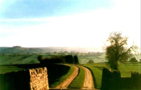
The Scenery
The scenery of the Limestone Way is very nice, although it improves the further north that you get, the section between Miller's Dale and Castleton being very scenic. At other places, for instance near Brassington and above the A52, you get very nice views over a long distance.
The walk in full:
| No. | From | To | Distance | Status | |
|---|---|---|---|---|---|
 |
1 | Rocester | Thorpe | 10.9 | Completed |
 |
2 | Thorpe | Matlock station | 13 | Completed |
 |
3 | Matlock station | Pomeroy | 16.9 | Completed |
|
4 | Pomeroy | Castleton | 14 | Completed |
The Path
The Limestone Way uses a combination of both footpaths, tracks and roads. For this reason it can be harder going than other routes that stick solely to footpaths. That having been said, the roads that it does use are all quiet, and does mean that you can generally move faster than would otherwise be the case.
The route passes through many attractive little villages but no towns; it skirts both Ashbourne and Matlock (although there are link routes to both of these towns). As such it is a perfect walk for people who want to be rural but still have little luxuries (such as B&B every night, or coffee shops for lunch).
The villages on the route have names that conjure up the best of the Peak District National Park; Youlgreave, Ilam, Thorpe, and Castleton to name a few. Pick a lovely summers day not a bank holiday and enjoy these lovely places.
In places the route involves a great deal of up-and-down'ing into and out of valleys, particularly in the sections between Parwich and Monyash.
Transport
Transport in the Peak District National Park is not what it could be. There are train services from Uttoxeter near the southern end of the walk, Matlock in the middle and Hope or Edale at the northern end. Unfortunately, the main route touches none of these places, although a branch of the walk does reach Matlock.
For the rest of the route you will have to rely on the local bus services, which can be rather sparse, especially at weekends out of season. Basically all the villages (eg. Monyash) on route will have services, but do not expect to find many bus stops out in the hinterland.
Links
I have not been able to find many resources about the Limestone Way on the WWW. However, below are the few that I have found:
- See A White Peak Way for details of a similar 36 mile walk to Castleton from Ilam.
