Walk #22: The Limestone Way from Matlock to Pomeroy
General Data
| Date Walked | 22/05/1999 |
| County | Derbyshire |
| Start Location | Matlock station |
| End Location | Pomeroy |
| Start time | 09.15 |
| End time | 17.35 |
| Distance | 16.9 miles |
| Description | This was the first day of the Limestone Way between Matlock and Pomeroy. |
| Pack | Today I carried full hiking kit, including tent, cooker and sleeping bag. |
| Condition | I feel reasonable after this walk. I have got some trouble with my thighs where they have been rubbed on by my boxer shorts. I am quite fatigued, but this is to be expected after carrying my pack over such terrain. |
| OS map | Outdoor Leisure number 24 (The Peak District - White Peak Area) |
Map of the walk
Maps courtesy of Google Maps. Route for indicative purposes only, and may have been plotted after the walk. Please let me have comments on what you think of this new format. For a detailed table of timings for this walk, please see the table file.
Notes
As I lay in my tent in Pomeroy I feel knackered, yet exhilarated. The walk from the point where I left the Limestone Way (about a mile north of Monyash) to Pomeroy was a real killer. Still, I am pleased that I have got this far.
As for fitness, I have a slight redness where my boxer shorts have rubbed against my thighs. My ankle, however, is fine, and has given no major trouble all day.
I have just had a shower, and have discovered that my thighs are so sore that they were bleeding, so I have strapped them up - one with strips of plaster and the other with moleskin. I will see how they are in the morning before deciding on my plan for the day.
There are some girls camping in two tents next to mine who are on a Duke of Edinburghs Award scheme, and have just walked from Hulme End. Trust my luck for them to be having their teachers staying with them! ;*)
It is darned windy outside, and on this campsite we are fairly high up and exposed. I'm starting to develop a complex that the flysheet is going to be blown away - due to my tent's inherent stability I didn't bother to put any guy ropes out.
A quick question - how far is 12 leagues? I am listening to Radio 4 on my walkman (whilst waiting for the weather forecast) and they're currently playing Orson Welle's version of "Les Miserables", and the main character has just said that he has walked 12 leagues.
The walk today took 1 hour 36 minutes longer than was planned, including only 20 minutes worth of breaks. One mistake I did make was that I did not take enough breaks - the first time I allowed myself to sit down for any significant period was at the end of Bradford Dale, more than halfway into the walk. Really I should factor 5-10 minutes of rest period per hour of walking, and hopefully this will stop me tiring myself out too quickly at the beginning of the walk.
Fortunately tomorrow there is not as much climbing, thank goodness!
(Sunday morning, 23/05/1999)
I feel much better. I have started packing for todays walk. The night was unsettled - strong winds, both outside and inside the tent!
Directions
For more details of this walk, see the book "Walking the Limestone Way", by R&E Haydock, B&D Allen, Scarthin Books, ISBN 0 907758 92 4. The only exception to this is the very end of the walk, where I walked west from just south of Flagg along roads to the campsite beside the A515 in Pomeroy.
Since 1994, the Limestone Way was extended from it's previous Matlock to Castleton route, to the new Rocester to Castleton alignment. The old route now forms the northern leg of this walk, and is still by far the most frequently walked. In the future I will walk the Rocester to Matlock section that I have yet to do, although knowing the area I actually believe that there are better alignments that can be walked, and that the route they chose for this section was constrained by having to reach Matlock.
Distances
| From | To | Distance (m) | Ascent (ft) | Descent (ft) |
|---|---|---|---|---|
| Matlock | Bonsall | 2.0 | 689 | 364 |
| Bonsall | Youlgreave | 6.6 | 889 | 1096 |
| Youlgreave | Monyash | 5.3 | 1161 | 741 |
| Monyash | Pomeroy | 3.0 | 430 | 56 |
This makes a total distance of 16.9 miles, with 3169 feet of ascent and 2257 feet of descent.
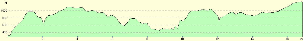
For more information on profiles, ascents and descents, see this page
Disclaimer
Please note that I take no responsibility for anything that may happen when following these directions. If you intend to follow this route, then please use the relevant maps and check the route out before you go out. As always when walking, use common sense and you should be fine.
If you find any information on any of these routes that is inaccurate, or you wish to add anything, then please email me.
All images on this site are © of the author. Any reproduction, retransmissions, or republication of all or part of any document found on this site is expressly prohibited, unless the author has explicitly granted its prior written consent to so reproduce, retransmit, or republish the material. All other rights reserved.
Although this site includes links providing convenient direct access to other Internet sites, I do not endorse, approve, certify or make warranties or representations as to the accuracy of the information on these sites.
And finally, enjoy your walking!
This walk was mentioned in the following routes:
| My sectional Land's End to John O'Groats walk |
Nearby walks
| # | Title | Walk length (miles) |
|---|---|---|
| 11 | Stanton Moor | 2.9 |
| 12 | Darley Dale, Stanton Moor and Rowsley | 8.7 |
| 14 | Friden, Long Dale and Gratton Dale | 7.8 |
|
|

|