Walk #102: Taunton to Langport
 |
 |
|
General Data
| Date Walked | 05/08/2000 |
| County | Somerset |
| Start Location | Taunton |
| End Location | Langport |
| Start time | 10.46 |
| End time | 17.30 |
| Distance | 15.9 miles |
| Description | This was a pleasant and varied walk with little climbing to be done. |
| Pack | Full Pennine Way-spec kit. |
| Condition | I feel in reasonable shape after this walk. I have a couple of little blisters on my toes, and my feet ache as usual from my boots. Apart from this I am slightly dehydrated despite drinking two litres of water. I also have a potentially nasty insect bite on my left hand that I obtained near the end of the walk. |
| Weather | One word can sum up today's weather, and that is 'hot'! When I set off there was some cloud, but it soon evaporated away and left constant sunshine in its wake. A very hot afternoon therefore resulted, with little wind to take the bite out of the heat. |
| OS map | Landranger number 193 (Taunton & Lyme Regis, Chard & Bridport) |
Map of the walk
Maps courtesy of Google Maps. Route for indicative purposes only, and may have been plotted after the walk. Please let me have comments on what you think of this new format. For a detailed table of timings for this walk, please see the table file.
 |
Notes
A nice walk that was slightly spoiled by an enforced late start and an oppressive heat that caused me to start becoming dehydrated.
The campsite in Langport is absolutely marvelous - it has a bar on site which, as well as providing the usual alcoholic beverages, also provides massive meals. My plate for a fry up was piled deep with more food than I could possibly hope to eat. Even with someone as voracious an appetite as mine could not hope to manage it all. The other faculties on the site are equally nice.
Fortunately I have what should be two easy days to follow, so I shall set off at about nine tomorrow morning, which will hopefully mean that I will be able to get into Glastonbury sometime after 13.00, which will give me all afternoon in which to explore the town.
I have suffered from a slight rash on the inside of my thighs that is causing me slight inconvenience - I have treated it as normal with some Vaseline and shall repeat the treatment in the morning, so hopefully everything will be okay.
It is nice finishing a day's walk and being able to cross off yet another leg of my Land's End To John O'Groats walk. As of today I have only five legs left to do before I have finished the entire English section of the walk. This gives me a really nice and satisfying feeling, indeed a sense of accomplishment of a scale that I have never really felt before.
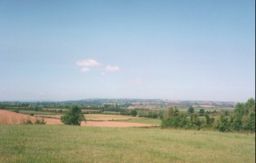
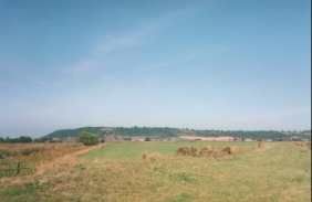
Some lovely views were available at certain times today - from the hill near North Curry the Quantocks should be see to the northwest. There were also nice views available from the footpath between Aller and the Bowdens campsite.
There were plenty of pubs en route today, allowing plenty of refreshment opportunities. I had a quick lunchtime break at a pub beside the church in Stoke St Gregory, which allowed me to take on some extra fluid on what was a very hot day.
At various points of the walk between North Curry and Meare Green footpaths had been blocked by electric fences, meaning that I had to divert from the footpath or even clamber over or under them. In one case the fence was actually strung about five feet away from a stile.
As usual on the first day I found my pack to be rather heavy, although I expect this to be far less of a problem tomorrow as my shoulders and back get used to the weight.
(The next morning). This morning is totally different to last night - we had some rain during the night and I opened the tent early to be greeted with the sight of a cloudy sky with no breaks in it, although the cloud does not appear to be very thick. It is also quite warm, and indeed it was warm enough last night for me to be able to sleep without my sleeping bag if I had wanted. However I decided that it was better to be over warm than cool, so I slept within it but with the side zip mostly undone. I listened to the weather forecast this morning and apparently the temperature in this area reached 26 degrees Celsius yesterday.
Directions
Head south out of Taunton railway station towards the town centre. Take the first left and then immediately turn left again, to head along a road between a cattle market on the right and an old railway goods yard on the left. The road curves slowly around to the right, and before long turns to cross over the Taunton to Bridgwater canal via a bridge. Join the canal and follow the towpath on its right-hand side. Note that you could also follow the river via Ruishton for this section of the walk.
Follow the canal towpath as it winds northeastwards and then eastwards past Bathpool and under the M5 motorway. From here it is a straight section of canal into Creech St Michael. At the first road bridge that you come to in Creech leave the canal and follow the road to the right, heading south through the village. When the road turns to the right head straight on down a track past the church. A footpath leading off to the right allows you to walk alongside the river Tone as far as Ham.
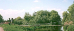
At Ham a pedestrian bridge allows you to cross the river and get into the village itself. Head up the road from the bridge and when you reach a crossroads turn left to head east out of the village. At a junction take the track heading to the north past a suspension bridge and shortly afterwards you find a footpath that heads off uphill to the right. Take this footpath eastwards up the hill into the village of Knapp. At the top of the hill there was a narrow offset stile that proved impossible to get my pack through, so I ended up having to climb over it.
Join the road in Knapp and follow it east into Lower Knapp. At a triangular junction a footpath leads off to the northeast. Take this footpath and follow it as it turns to the east and heads into the village of North Curry. When you reach a road in North Curry turn tight and head uphill into the centre of the village. Take the first left by the green and then turn left again, to head downhill again. Enter the churchyard and take a footpath that heads though the churchyard and down the hill at its rear.
Follow this footpath northeastwards, and then turn right along another footpath (part of the River Parrett Trail) that heads into Meare Green. Cross the road and follow the Trail across fields and onto another road. Turn left and follow the road into the village of Stoke St Gregory. At the church the Trail goes to the right, but another minor road heads straight on right through the centre of the village. At the church there is a nice pub that I called into for twenty minutes to cool off.
At the end of this road turn left and rejoin the River Parrett Trail. Almost immediately you turn right again and head past Parsonage Farm and over a railway bridge, before descending down to the River Parrett at Stathe. Head straight on and cross the River Parrett via a bridge and turn right to walk on the banking between the River Parrett and the River Sowy. Follow this path south-eastwards past Oath Lock until you come to a footbridge crossing the River Sowy. (Note that there is another bridge carrying a farm track over the River a few hundred yards earlier. Do not take this).
Cross over the River Sowy and follow the footpath northeastwards across fields to the church at Aller Court. Enter the churchyard and cross it to reach a track. Turn right and follow this track into Aller and onto the A372 road. Turn left up the A372 onto the outskirts of Aller, where a road can be seen to the right that heads steeply up the hillside.
Take this road and continue up the hill on a footpath when it ends. At the top of the hill an intermittent green track is joined, which you turn right down. In places this is very overgrown. The campsite at Bowdens is about a kilometre down this track, and adjacent to it.
Accommodation
I stayed at Bowden's campsite, which is situated high on a ridge between Langport and Aller, to the northwest of Langport. It is a very nice campsite, with good facilties.
Distances
| From | To | Distance (m) | Ascent (ft) | Descent (ft) |
|---|---|---|---|---|
| Taunton station | North Curry | 6.9 | 276 | 249 |
| North Curry | Bowden's campsite | 9.0 | 623 | 472 |
This makes a total distance of 15.9 miles, with 899 feet of ascent and 721 feet of descent.
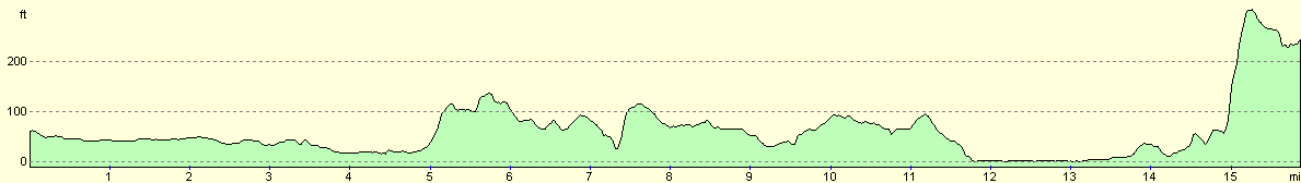
For more information on profiles, ascents and descents, see this page
Disclaimer
Please note that I take no responsibility for anything that may happen when following these directions. If you intend to follow this route, then please use the relevant maps and check the route out before you go out. As always when walking, use common sense and you should be fine.
If you find any information on any of these routes that is inaccurate, or you wish to add anything, then please email me.
All images on this site are © of the author. Any reproduction, retransmissions, or republication of all or part of any document found on this site is expressly prohibited, unless the author has explicitly granted its prior written consent to so reproduce, retransmit, or republish the material. All other rights reserved.
Although this site includes links providing convenient direct access to other Internet sites, I do not endorse, approve, certify or make warranties or representations as to the accuracy of the information on these sites.
And finally, enjoy your walking!
This walk was mentioned in the following routes:
| My sectional Land's End to John O'Groats walk |
Nearby walks
| # | Title | Walk length (miles) |
|---|---|---|
| 94 | Crowcombe Heathfield to Taunton | 11.5 |
|
|

|