Walk #125: Cheddar to Farrington Gurney
 |
 |
|
General Data
| Date Walked | 26/11/2000 |
| County | Somerset, Avon |
| Start Location | Cheddar YHA |
| End Location | Farrington Gurney |
| Start time | 08.00 |
| End time | 15.45 |
| Distance | 13.7 miles |
| Description | A nice walk, starting with a climb up to the top of the Mendip Hills via Cheddar Cliffs, and ending with a traverse eastwards towards Midsummer Norton. |
| Pack | Today I carried a large pack with no tent. |
| Condition | I feel in reasonable condition after this walk. The underside of my feet ached a lot during certain stages of the walk, but after the stops they improved for the next few miles. My right shoulder is aching and a bit sore, but this is fortunately not noticeable with my pack on and positioned correctly. Otherwise everything is fine, and my ankle has not caused me any problems. |
| Weather | Today was a day which had a little bit of everything. The day started off very windy, although there was little cloud about (and the little that there was, was blown away very quickly). On the high parts of the Mendips the wind was very noticeable and caused it to be quite chilly, even when the sun was shining. I spent the first few hours walking with no coat on, but a short heavy shower caused me to put it on. This set the pattern for the rest of the day, with a couple of sharp showers interspersed with some sun and even a hailstorm in the ever-present strong wind. |
| OS map | Landranger number 172 (Bristol & Bath, Thornbury & Chew Magna), Landranger number 182 (Weston-super-Mare, Bridgwater & Wells) and Landranger number 183 (Yeovil & Frome, Shaftesbury & Shepton Mallet) |
 |
Map of the walk
Maps courtesy of Google Maps. Route for indicative purposes only, and may have been plotted after the walk. Please let me have comments on what you think of this new format. For a detailed table of timings for this walk, please see the table file.
Notes
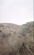
This was a lovely walk that was not spoiled by the slightly inclement weather. In particular the route along the Cheddar Cliffs north of Cheddar was very nice, with some spectacular views being available to the south over the Somerset Levels (with even Glastonbury Tor being visible in the distance), and down Cheddar Gorge itself. however taking the cliffs route instead of following the road meant that I gained a great deal of height only to lose most of it again on the descent down to the road at Black Rock Gate. The walk along the top of the cliffs was very exposed and cold when the wind gusted.
The going was generally better than it was yesterday, although it was still very muddy in places. When I reached the B&B I was very muddy, particularly my right leg where my waterproof trousers had ripped yesterday. I am getting ever so slightly fed up with all the mud, and unfortunately tomorrow looks as though it may have more of the same.
Because of the mud when I left the pub in Litton and found a road signposted "Farrington Gurney 2 miles", I decided to follow it instead of trawling my way through the mud, particularly as I was in the middle of a heavy shower. Unfortunately this road was off my OS maps, and so I had no real idea where it went. Unfortunately it led onto the A39, which I had to follow for about a mile and a half north into Farrington Gurney.
I spent an hour in the pub, the King's Arms, in Litton with an Australian gentleman whom I had met on the ascent up to the road on Smitham Hill. He was with his English girlfriend, a horsy girl who had broken her back falling off a horse. She had mostly recovered from that trauma and still rode, but she had lost some of the feeling in her legs. They were a fascinating couple, and I spent a long time chatting to them. the pub itself was very nice, but was very busy on this Sunday lunchtime and the waiting time for food was very long, so I did not bother and had a pack of peanuts. I also met a family going in the opposite direction on the descent from Hook's Hill into Litton, one of whom, a girl in her twenties, had just come back from a five-and-a-half month trek along the Pacific Crest Trail, which follows the mountains on the western coast of the USA - the lesser known twin to the famous Appalachian Trail. An amazing girl - her friend had dropped out fairly early and she continued on her own!
Near Warren Farm in Velvet Bottom I met up with the kids from the Air Training Corp again - they had been staying in a bunkhouse there. We had been bumping into each other every so often for the last day, but they were packing up their tents and getting ready to leave (indeed I held the gate at the top of the lane open for their minibus).
The B& B in Farrington Gurney is very nice, and the building itself is very nice and displays some interesting architectural features. The landlady is very nice, and I had a long chat with her and some of her family. I had a meal and a couple of pints in the Farrington Inn this evening, which is literally just down the road from the B&B. It was quiet which was nice as it allowed me to write my notes, and I had a Beef Sunday lunch which went down well with the Bass that I was drinking.
Directions
Leave the YHA and turn right down the lane to The Hayes. Turn left down this road and follow it to a T-junction with Tweentown. Turn right and head down to another junction, this time with Cliff Street. Turn left and cross a stream via a bridge, and then turn right up The Lipplatt. The first road to the left is called Lynch Lane, and this leads sharply uphill. At the top of Lynch Lane a footpath starts. This path heads uphill, and eventually brings you out at a metal tower, which is a lookout post. Climb up it if you want some lovely views, and then continue walking northeastwards, following the edge of the Cheddar cliffs.
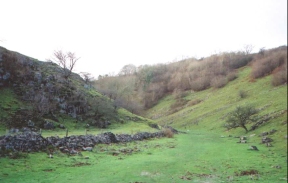
Along this section there are some lovely views to the south, looking over Cheddar and Cheddar Lake, and northeastwards along Cheddar Gorge. Eventually the route starts to descend down to the B3135 at Black Rock Gate. Carefully cross the road and enter the nature reserve of Black Rock. Head eastwards along the valley for about half a kilometre until a stile on the right leads into a broad valley that heads eastwards. This valley is Velvet Bottom, and features some quite unusual stepped terraces.
The path becomes a track at a building which the ATC boys were staying in. This track continues though a gate and comes out on a bend in a minor road. Cross over this road and follow a path that becomes a track through Charterhouse. The track emerges out onto the B3134 just past some houses. Turn left and then almost immediately right and heads eastwards down a minor road past Hazel Warren Farm.
Continue along this road as it heads in a roughly eastwards direction past Home Farm and Harptree Farms. Pass just above the Wellsway Inn and follow the road down a steep hill and across a stream (although the road was the stream when I passed). Just pas the stream a stile leads heads uphill to the right (south) and comes out on a road near the top of Smitham Hill. Continue south along this road for a short distance to Pitt Farm.
At Pitt Farm a track and footpath leads off to the southeast towards Nettwood Farm. Before the farm is reached the footpath leaves the track and heads eastwards. Along this track to the northeast of the Farm is the old county of Avon's highest point. Continue on along the footpath eastwards until a road is reached at Greendown.
Turn left down the road and head downhill. The road bends around to the east and to two nearly adjacent roads, the first coming in from the north and the second from the south. At the latter of these two junctions a path heads off to the left (make sure it is not the more obvious bridleway). This path skirts the southern edge of the wood on Hook's Hill and then descends to join the B3114 at Litton.
Turn right and walk along the B3134 for a short distance past the King's Arms, and then take the first road to the left past the pub. Follow this for a short distance and take another road to the right, that bends slightly to head east as it heads steeply uphill. At the top of this hill a footpath heads off to the left, which avoids the A39 section that follows if you stick to the road as I did. This road heads along fairly straight for nearly 750 metres to the A39.
Turn left along the A39 and follow it northeastwards to the junction with the A37 near the top of Rush Hill. Continue along the A37 as it descend downhill into Farrington Gurney.
Distances
| From | To | Distance (m) | Ascent (ft) | Descent (ft) |
|---|---|---|---|---|
| Cheddar YHA | B3134 | 4.6 | 1299 | 489 |
| B3134 | Avon's highest point | 4.1 | 413 | 397 |
| Avon's highest point | Farrington Gurney | 5.0 | 285 | 761 |
This makes a total distance of 13.7 miles, with 1997 feet of ascent and 1647 feet of descent.
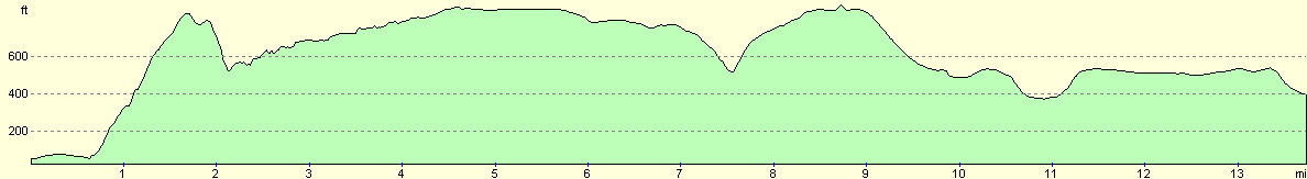
For more information on profiles, ascents and descents, see this page
Accommodation
I spent the night at The Parsonage, an excellent B&B in Farrington Gurney. The cost was 30 pounds for the night, and although this is more than I would normally like to pay, it was well worth it. The building itself is very nice, with stone floors, and the proprietor was very friendly, and she made me a nice warm pot of tea when I arrived to warm me up. The Parsonage is a fine grade II* listed sandstone building in the style of a French chateau, built in the 17th century. It was once a resting place for Bishops visiting Wells. Tel. 01761 453553.
Disclaimer
Please note that I take no responsibility for anything that may happen when following these directions. If you intend to follow this route, then please use the relevant maps and check the route out before you go out. As always when walking, use common sense and you should be fine.
If you find any information on any of these routes that is inaccurate, or you wish to add anything, then please email me.
All images on this site are © of the author. Any reproduction, retransmissions, or republication of all or part of any document found on this site is expressly prohibited, unless the author has explicitly granted its prior written consent to so reproduce, retransmit, or republish the material. All other rights reserved.
Although this site includes links providing convenient direct access to other Internet sites, I do not endorse, approve, certify or make warranties or representations as to the accuracy of the information on these sites.
And finally, enjoy your walking!
This walk was mentioned in the following routes:
| My sectional Land's End to John O'Groats walk |
Nearby walks
| # | Title | Walk length (miles) |
|---|---|---|
| 104 | Glastonbury to Wells | 7.2 |
| 124 | Wells to Cheddar | 11.3 |
|
|

|