Walk #291: Reculver to Ramsgate
 |
 |
|
General Data
| Date Walked | 09/12/2002 |
| County | Kent |
| Start Location | Reculver |
| End Location | Ramsgate |
| Start time | 08.30 |
| End time | 14.53 |
| Distance | 17.4 miles |
| Description | This was a nice walk following good seawalls and roads eastwards to Foreness Point and then south down to Ramsgate. |
| Pack | Today I carried my 30-litre Karrimor HotRock rucksack, which was filled with my packed lunch, waterproof leggings, water bottle and a couple of spare shirts, together with the usual assortment of odds and ends. |
| Condition | I have had some more trouble with my ankle today, which is highly annoying as I had thought that the problems that I had with it last week had gone. The aching was not too bad, but it was most certainly there. Aside from this everything was fine, and I could have walked further if I had needed to. |
| Weather | The main feature of today's weather was the wind, which was a fairly fierce headwind for most of the day which at times made progress hard. On the positive side it was a sunny day, which meant that I could gt some nice views out over the North Sea. It was a bitterly cold day, especially when exposed to the wind, and I am very glad that there was no rain as that would have made the day truly awful. |
| OS map | Landranger number 179 (Canterbury & East Kent, Dover & Margate) |
 |
 |
|
 |
 |
|
Map of the walk
Maps courtesy of Google Maps. Route for indicative purposes only, and may have been plotted after the walk. Please let me have comments on what you think of this new format. For a detailed table of timings for this walk, please see the table file.
 |
 |
|
Notes
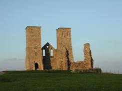
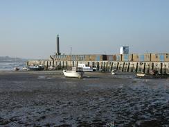
Reculver looked beautiful in the early morning light, with the two towers of the church glowing in the light. I spent a few minutes exploring the ruins of the church and then went down to look at the old Roman wall. It was when I went down to the wall that I realised I had been here before - over ten years before I had been doing a Geological Engineering degree at QMW in London, and this course involved geology field trips. At one of these trips we went to look at some Roman concrete, and to do this we went down to Reculver to visit the walls. I had always thought that the place that we had visited was further south at Richborough, but I recognised precisely where we had stood at Reculver
Today I have turned my first right-hand corner of the walk. This is one of the four corners of Britain, and is the place where I change from travelling down the east coast to walking along the south coast. This is a fairly arbitrary pint, but many feel that it is the area between Foreness Point and North Foreland. The next corner will be at Land's End, where I change from walking along the south coast to the west coast. It is nice to reach another milestone of the walk, and it was very much a highlight of the walk so far.
In a strange way I had been looking forward to the walk today as I was scheduled to pass through Margate. In the middle of 95 I left London after four years, and some friends of mine from South London took me out on what they called a typical South London day out, to Margate. My overriding memories of the trip are of every other shop along the seafront selling football shirts and other tacky goods, and the Ferris wheel in the funfair dominated views of the town. It had seemed as if half of South London were at the seaside on that day, and ever since it had always been my idea of a horrible seaside resort, and I had always mentioned it as such.
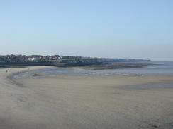
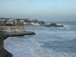
It was therefore with a little intrigue that I came back to the town, and I must admit that I think that I have been harsh to the town. It was out of season and the town was fairly quiet (although far from dead), and many of the shops were shut. This time I found much more of interest; they are restoring the railings along the seafront, the clock tower is lovely, and most importantly for seaside resorts in winter everything was clean and tidy. I actually quite enjoyed the walk through the resort and it was far from the worst that I have seen on this trip. I daresay that if I visited it again on a summer's Sunday I may well dislike it once again, but out of season it had a certain elegance and, most importantly, did not appear to be run down.
I had arranged to meet Sam in Ramsgate, where I had been planning to end the walk. As I was cresting a hill about two miles north of the town I could see a campervan in the distance parked on the roadside on the top of the next hill. As I approached it I could see that it was a Royale van, and that it had a top box. This was much earlier than I had wanted to finish the walk, so I was preparing to tell Sam that I was going to walk on further. As I got closer it was obvious that it was an N-reg van like ours, but the registration was wrong. It turned out that the van was a Royale 630, whereas ours is a 610. I wonder what the odds are of seeing a van similar to ours only a few miles away from where I am expecting to end a walk?
Broadstairs was a nice little town, and I diverted away from the seafront so that I could have a walk around it. The town has a strong connection with Dickens, as he wrote several of his books whilst staying in a house, which is now called Bleak House. The town has some lovely narrow streets, and it is not overly commercialised.
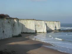
As I followed the seawall around Birchington I could see lots of little entrances leading into the chalk cliffs above me. Most of these had been bricked up, and I wondered if these may have been entrances into Second World War bomb shelters, which I knew had been built into chalk cliffs in some towns. A few of these entrances were open, and one included steps leading up into the gloom. I was tempted to climb these steps into the dark and damp interior to explore it, but the roof was quite low and I id not have a torch with me.
Directions
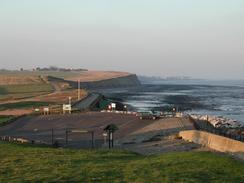
This walk starts off at the car park to the west of the ruins of St Mary's Church at Reculver. Leave the car park and climb up onto the hill beside the church and then descend down on the eastern side onto the seawall. Follow the seawall eastwards for over five kilometres, passing Plumpudding Island before reaching the outskirts of Birchington at the eastern side of Minnis Bay. The seawall continues on beneath the cliffs, passing Grenham Bay. The seawall ends at Epple Bay, and so climb up onto the road that runs along the top of the cliffs.
The seawall along the base of the cliffs soon restarts just past the eastern side of the bay, but I continued on along the road as it passes St Mildred's Bay into Westbrook. Here I descended down onto the sea wall and followed it into Margate. Walk along the sea wall through Margate, passing the clock tower and the jetty before climbing uphill along the B2051 road. At the top of the hill turn left and walk along a path which runs eastwards along the top of the cliffs past Palm Bay and onto Foreness Point.
At Foreness Point the path starts to turn to the right to had in a more southeasterly direction past Botany Bay to the remains of a tower at White Ness. Here the path heads inland to the B2052 road. Turn left to follow the road as it passes a large castle and skirts Joss Bay. Ata the bay turn left into a car park and follow a path that skirts the cliff edge as it climbs up into North Foreland. The path soon meets a road, which can be followed southwards until it wings around to the right and meets the B2052 road once more by Stone House.
Turn left to follow the B2052 southwards for a short distance until a road leads off to the left. Take this road as it heads back to the edge of the cliff and then turn right to follow it as it heads south into Broadstairs. Walk around the seafront of the town and then head southwards out the other side. A road follows the cliff as it heads southwards before it reaches a park. A path continues on through the park, which is above East Cliff, before descending down to meet a main road by the harbour. Pass the harbour and continue on along the road as it heads uphill. The walk ends a little further on along this road.
Distances
| From | To | Distance (m) | Ascent (ft) | Descent (ft) |
|---|---|---|---|---|
| Reculver | Margate | 8.8 | 344 | 348 |
| Margate | Ramsgate | 8.6 | 958 | 853 |
This makes a total distance of 17.4 miles, with 1302 feet of ascent and 1201 feet of descent.
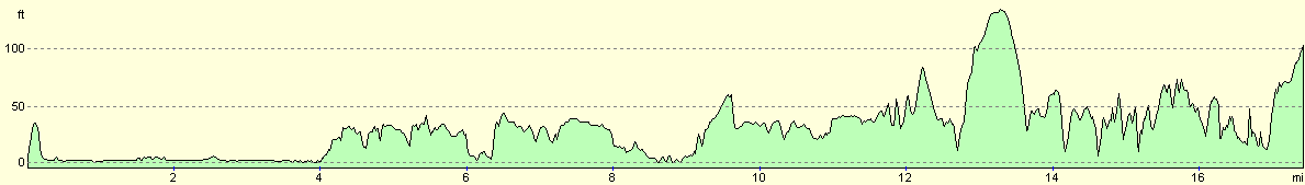
For more information on profiles, ascents and descents, see this page
Accommodation
We spent the night parked on the roadside in Ramsgate, which was okay except for the fact that it was a fairly cold night and we had to snuggle up to keep warm.
Disclaimer
Please note that I take no responsibility for anything that may happen when following these directions. If you intend to follow this route, then please use the relevant maps and check the route out before you go out. As always when walking, use common sense and you should be fine.
If you find any information on any of these routes that is inaccurate, or you wish to add anything, then please email me.
All images on this site are © of the author. Any reproduction, retransmissions, or republication of all or part of any document found on this site is expressly prohibited, unless the author has explicitly granted its prior written consent to so reproduce, retransmit, or republish the material. All other rights reserved.
Although this site includes links providing convenient direct access to other Internet sites, I do not endorse, approve, certify or make warranties or representations as to the accuracy of the information on these sites.
And finally, enjoy your walking!
This walk was mentioned in the following routes:
| My walk around the coastline of Britain |
Nearby walks
| # | Title | Walk length (miles) |
|---|---|---|
| 290 | Faversham to Reculver | 17.8 |
|
|

|