Walk #973: A circular walk between Matlock and Rowsley, taking in Stanton Moor
 |
 |
|
General Data
| Date Walked | 04/03/2013 |
| County | Derbyshire |
| Start Location | Matlock station |
| End Location | Matlock station |
| Start time | 09.32 |
| End time | 16.01 |
| Distance | 16.0 miles |
| Description | This pleasant walk follows the Derwent Valley Heritage Trail alongside the river to Rowsley, before returning via Stanton Moor and Peak Rail. |
| Pack | Today I carried my 30-litre Karrimor rucksack, filled with water, my waterproofs, a book and other odds and ends. |
| Condition | I feel absolutely fine after this walk. |
| Weather | Today was mostly cloudy, with some occasional suny periods. It was not too cold, and there was a bit of a breeze to help me cool off during the ascent onto the moor. |
| OS map | Outdoor Leisure number 24 (The Peak District - White Peak Area) |
 |
 |
|
Map of the walk
Maps courtesy of Google Maps. Route for indicative purposes only, and may have been plotted after the walk. Please let me have comments on what you think of this new format. For a detailed table of timings for this walk, please see the table file.
 |
 |
|
Notes
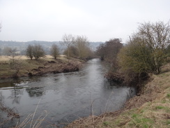
I had a few days spare and what looked like good weather, so I decided to do a short trip. I also had a new tent that I wanted to try out, so rather than risk a backpacking trip, it seemed sensible to do a car-camp. The Pennine Bridleway was on my to-do list, so early this morning I started the drive up to Derbyshire. As I would not be able to start walking until after nine, and a long first day on the trail, I decided to do a different stroll. Another trail on my list was the Derwent Valley Heritage Way, and so after parking at Matlock and grabbing some food I shouldered my rucksack and headed off.
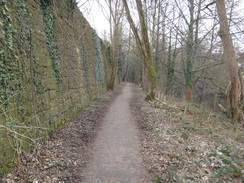
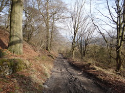
Matlock has changed over the last decade, with a relief road for the crowded A6 squeezing over the railway and River Derwent through the old Cawdor Quarry site. I had walked the initial stretch of the trail many times before; it squeezes between the river and a large retaining wall that once held a large railway yard. The path has not changed much except for the place where the large bridge carrying the bypass passes overhead.
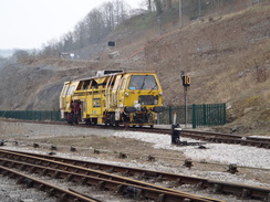
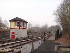
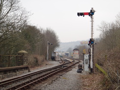
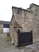
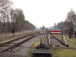
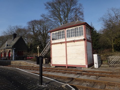
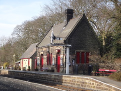
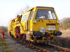
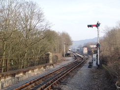
Shortly after this a path led up to the left, to the site of the Matlock Riverside station on the preserved Peak Rail line. Noise which i assumed had been from the old quarry site turned out to be a tamper machine on the railway, and there was also a classic Midland Railway-style signal box sitting on a rather brutal and no-typical base of concrete blocks. The box used to be at Luffenham Junction, and has only just been installed.
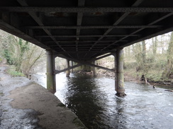
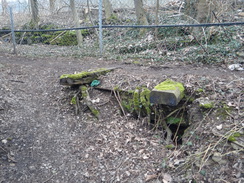
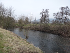
Soon afterwards the path passed under Bridge 35, which carries the preserved railway over the Derwent. I worked on helping restore this bridge in a minor way, and have happy memories of a sunny summer over the water. Despite having spent months in this area over the years, I had never actually walked the next stretch of path which continues along the western side of the Derwent. Initially it passed the site of the old Cawdor Quarry. A ramshackle concrete hut jutted out over the water, and nearby a few railway sleepers remained from the old quarry sidings, surviving after decades of disuse.
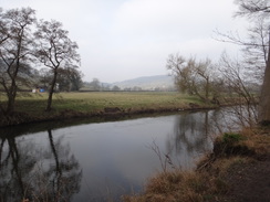
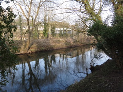
The stench of tar filled the air a little further on, and shrinkwrapped pallets were stacked against the other side of the fence. These turned out to be tar blocks, presumably for use in roofing or in waterlogged areas. Eventually the fence ended, and a notice by a stile stated that the footpath might soon become a cycle path. The path flirted with the river bank, which soon looped out of view before returning. It was a pleasant enough stroll on a side of the river I did not know too well, my previous walks all having followed the railway line.
A road headed northwestwards once the footpath ended, with the old volcanic plug of Oker Hill, topped by a lone sycamore tree that Wordsworth once wrote about . I have always had a hankering to climb Oker Hill as the views are meant to be superb, but lack of public access to the top has always put me off. The road passed a transport company on the left, before reaching Darley Bridge, an ancient crossing point of the river.
The Square and Compass pub on the other side of the river was an old watering hole of mine, and seemed not to have changed externally over the years. I followed the road as it twisted and turned, before taking a footpath that led across fields to the small hamlet of Churchtown.
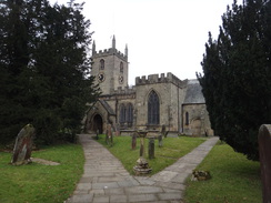
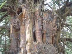
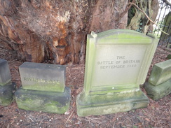
I diverted off to visit the yew tree in the church yard, which is reputed to be over 2,000 years old. Whilst this is probably an overestimate, its vast girth indicates it might have watched the original Saxon church being built. Stone tablets arranged around the base of the tree are engraved with the names of famous battles. Ancient yew trees have an almost mystical air, and the Churchtown sample is no different. Fortunately it seems in rude health and is vibrantly green despite its age.
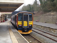
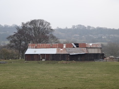
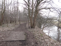
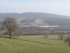
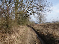
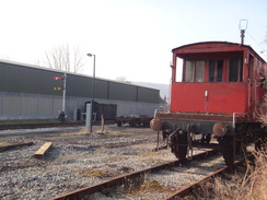
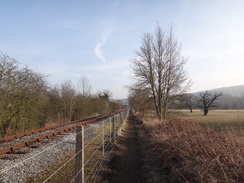
A track and then path led north, with the river some way away to the left. A four-mile long drain called Hill Carr Sough trickles into the other side of the river, carrying mineralised water from deep underground. Soon industrial works could be seen off to the right - the Rowsley depot of Peak Rail, where I spent many happy days. Even from a distance it was possible to see that it had changed over the years, with a new building over part of the site of the old Rowsley Depot, closed with the rest of the line in 1968.
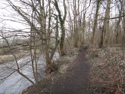
Soon the path became trapped between the river and the old depot, now neatened up by the preserved railway, and joined the current end of the line at Northwood. Some men in high-visibility jackets were working nearby, and I ended up chatting to one for a quarter of an hour - he started volunteering a few years after I left, but we knew many mutual names. It was a pleasant chat, but left me with a sadness for all the people who have moved on - some to other preserved railways or hobbies, and a few out of this life.
Heading north, the path headed through the massive area of the old marshalling yards, where trains were organised before attempting the climb over the Peak District's hills. A few remains were visible in places: slabs of brickwork lying in the ground, recumbrant lampposts covered in moss; even half an old fishplate. Whilst there is a good chance that the railway will be rebuilt through here, the noise and bustle of the marshalling yard will never return.
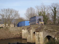
I walked in a reverie until the path erupted out through an industrial estate towards the site of the old Rowsley station. The station building was demolished by Peak Rail for stone, and the site is now a car park. It will be difficult to rebuild the railway past the buildings and have enough gradient to cross the A6 a short distance away, but apparently it is doable.
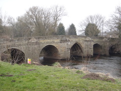
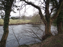
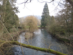
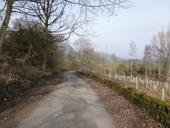
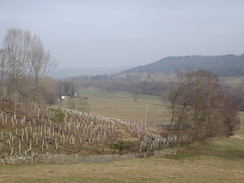
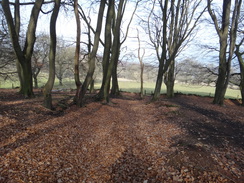
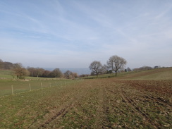
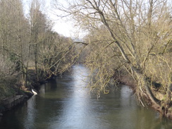
I crossed the bridge over the Derwent. And then took a road past Caudwell's Mill, and then a long, surfaced driveway that crossed the floodplain. This started to rise past an area of newly-planted trees, replacing some mature woodland that had once stood there. The plastic tubes protecting the saplings looked incongruous amongst the stumps.
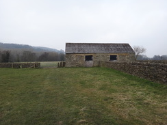
Eventually the trail reached Stanton Woodhouse Farm, which had some wonderfully worn stone flags outside the farm. Another climb along a path led past Hillcar Wood and Endcliffe Quarry; last time I walked along here I passed a protestor's camp, housing men and women who wanted to prevent the camp from reopening. They won their battle and moved on in 2009. They did a good job at tidying up, and there was no obvious sign of their presence.
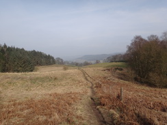
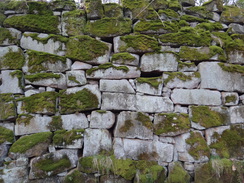
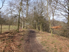
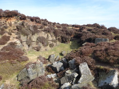
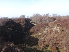
Another road led below the eastern flank of Stanton moor, past a series of disused quarries. A new footpath has been built up along a tree-lined access track, but I continued along the road past a massive dry-stone wall that soared over my head. There was no sign of any mortar, the vast weight of the blocks holding them in place. Machines were driving around a quarry to the north of the road; I could not remember this quarry, making me wonder when it opened.
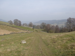
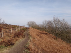
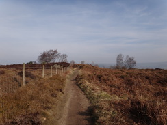
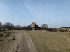
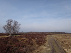
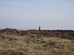
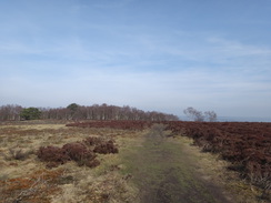
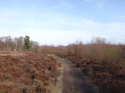
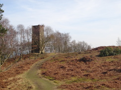
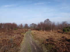
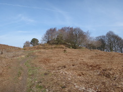
A path led up onto Stanton Moor, and as there was still time I decided to do a lap around the moor. I soon joined the path that runs along the eastern edge of the moor; trees blocked most of the views, but the sandy path made for an enjoyable stroll. Soon the Reform Tower (also called Earl Grey Tower) came into view; this was built to celebrate the Great Reform Act 1832. When I first came onto the moor I knew this as the 'shooting tower', and was told someone would stand at the top and tell people where the grouse could be found. Whether that is true or not I do not know, and the tree cover would prevent it nowadays.
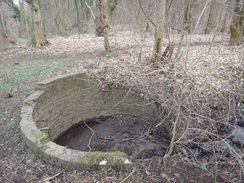
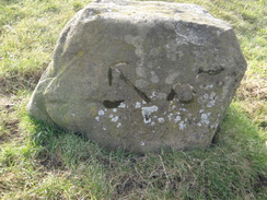
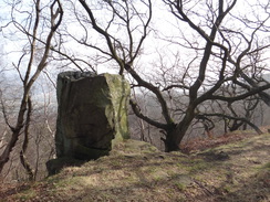
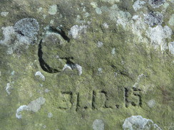
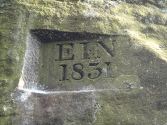
A massive boulder, carved with footholds, was situated at the cliff edge a little further on. Engraved graffiti on the stone dated back nearly 200 years, showing that it is hardly a modern phenomena. The trees soon ended, and the path continued on along the edge of the moor; eventually I crossed a stile over a fence to enter the moor proper. Jumping off the stile, I put my foot on a black plastic bag that split open, revealing the contents to be dog poo.
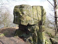
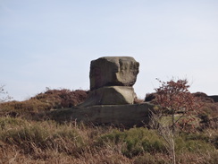
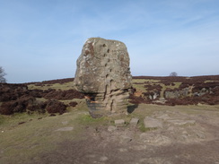
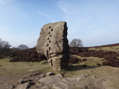
An old quarry on the moor was being reclaimed by nature, shrubs and small trees springing up around blocks that had been quarried but not removed. Then one of my two main targets on the moor came into view - the Cork Stone. This is similar to the boulder I passed earlier, except for the fact it is in a more exposed location. Steps cut into the rock also lead to the top, along with metal hoops for footholds. I decided not to attempt a climb, and instead started across the moor in company of a couple who were on a pub walk.
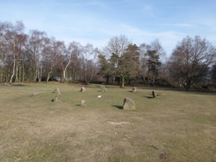
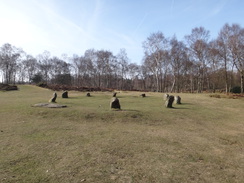
We chatted as we strolled across the moorland, passing a couple of old quarries that had nibbled away at the western edge of the moor. Soon we came across a small solitary stone, and continued on to reach the Nine Ladies Stone Circle. This is my favourite prehistoric site, the small stones standing in a clearing amongst the trees. It is a magical site and it is clear others feel so as well - ornaments were hanging off the trees, and a memorial to a woman had been placed in the centre of the circle.
We walked on back towards the Reform Tower, after which I said goodbye to the couple and headed back across the moor. I like moorland walking, and this was a superb stroll in the sunshine. It was a shame when I crossed the stile once more and joined a path that led down to a road that leads into Birchover. Another path took me south; I went slightly wrong after passing a farm and walked the wrong way across a field; fortunately I realised my mistake and continued my descent towards Clough Lane.
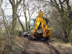
This track took me east; there were some pleasant views through the trees on the left back towards Stanton Moor. A JCB was blocking the track at one point, the driver sitting in the cab as he admired the views whilst a chainsaw sat on the ground beside some fallen trees. The descent steepened as the track passed Cowley Knowl, the ground being slightly hard on my tired feet.
Soon it joined a road that passed the massive works belonging to H.J. Enthoven and Sons. This plant started off processing the lead mined from the moors in the area, including its own Mill Close Mine. Once the mining stopped, it remained open to process second-hand lead, for instance from batteries. The factory's massive chimney rather dominates the area and seems out of place in the Peak District scenery; however it is an indication of the fact that the hills of the Peak District have been the site of industry since Roman times.
I descended down to recross the Derwent at Darley Bridge, then walked up to the Peak Rail station at Darley Dale. A path led alongside the South Yard, where many of the sidings I had helped lay in the late 1980s and early 1990s had been taken up and moved elsewhere. There were a few items of stock, but soon I was climbing up some steps onto a stone overbridge, before another path led back to the railway line at the end of a cutting.
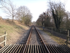
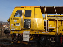
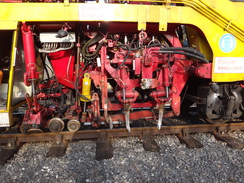
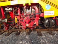
I had walked along the railway line many times in the past; indeed, I had helped build this stretch of line many moons ago. It was a pleasant stroll that caused me to once more dive back into my memories of the people I used to know. As I approached the bridge over the Derwent once more, I saw the taper machine that had been at Matlock Riverside earlier in the day coming towards me, tamping the line. Tamping machines have prongs that descend into the ballast, vibrating it to settle it and make the foundations of the railway line firmer. I have done many hours of this by hands, and it is amazing to see how quickly a machine can do the hard, physical work of many men.
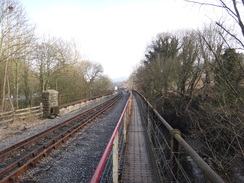
Soon I was recrossing the Derwent once more using a narrow walkway across the railway bridge, the path being formed by a series of riveted plates, the rivets making for slightly uncomfortable going on my feet. After this I dropped down to follow the riverside path I had walked earlier, and soon reached the centre of Matlock and my car at the station.
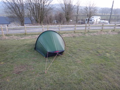
There was still a good amount of daylight left, so I took my time driving up to the campsite at Blackwell, near Taddington in the heart of the Peak District. The owner was not in, but some men told me to put up my tent anywhere in the field - I was only the second camper they had had so far this year! It was going to be my first night in my new Akto tent, and I took my time erecting it. It had been a good day's walk that held many memories for me.
 |
 |
|
Directions
This walk starts at Matlock railway station at SK296601. Leave the station and walk down the approach road, with a large footbridge to the right. The path squeezes past the bus station buildings on the left, and then curves to the right to parallel the A6 Derwent Way. Cross to the northern side of the road at a pedestrian crossing just before the bridge, and immediately turn left to join a footpath that passes between the road on the left and the River Derwent on the right.
Continue along the footpath as it follows the river; it passes under a large bridge that carries the A6 overhead, and after 0.7 miles passes under an old metal bridge that carries a railway line over the river. On the other side of the bridge the path rises up to run alongside a fence at the top of the raised riverbank, with the water far below. Quarry buildings are passed on the other side of the fence to the left after a third of a mile, and eventually a stile is reached at SK281608. (It should be noted that the next stretch to Oker may be converted into a cycle path, in which case the following notes will change).
Cross the stile, and join the riverbank on the right. At the end of this field go through a stone squeeze-stile and then angle slightly left across a second field. Go through a pedestrian gate at the endof this field and aim slightly right across a third field, with houses away to the left. A third pedestrian gate leads out to a path that runs between hedges up a slight slope. At the top go through a stone squeeze-stile to reach a road in Oker at SK279611.
Turn right and follow the road as it heads back downhill. When the road forks after 300 yards take the left-hand branch that leads to a stile beside a field gate. Continue along the road on the other side as it curves along a good field, with the river away to the right. When the field ends at SK274618 negotiate a complex of stiles beside a field gate and continue along the road, passing houses on the right. After a quarter of a mile the road ends at a T-junction with the B5057 in Darley Bridge.
Carefully cross the road to the other side, then turn right to cross the bridge over the river. It immediately curves to the left and then gently to the right; just before Darley Bridge car park is reached on the left, turn left through a squeeze-stile beside a field gate to join a track, with some playing fields off to the left. When the track curves sharply to the left, continue straight on through a squeeze-stile beside a field gate to enter a field.
Follow a ditch on the right past the field. Just before the corner of the field is reached, turn right through a squeeze-stile, then cross the ditch on a stone-plank bridge and go through a pedestrian gate to enter another field. Head diagonally across this, skirting a corner of a fence on the right to reach the corner of the field beside the churchyard. Go through a clapper gate beside a field gate to reach a road in Churchtown at SK267628.
Turn left to follow the road as it passes St Helen's church on the left; as the road curves t the rght, turn left down another road. Pass a school on the left and go through a gateway to join a track that runs past the main farm on the left. Cross a stile beside a field gate; as this track curves to the right towards a barn, cross a second stile/field gate combination that leads to a short section enclosed between hedges. After about fifty yards, cross a stone step-stile beside a field gate to enter a field.
Follow a wall on the right; in the corner of the field go through a stone squeeze stile beside a barn. Angle slightly to the right across a field, aiming for a gateway ahead. Go through a squeeze-stile beside the gate to enter a third field. Head across this to reach a wooden stile beside a field gate and head on across a field, as a railway depot becomes visible off to the right. Cross a stile beside a field gate and then start following a hedge on the right, with the depot. The field narrows as it squeezes between the river on the left and track on the right; go through a stile beside a field gate and continue along the path alongside the river. It goes past a final squeeze-stile gate combination to reach a large open area at Northwood at SK261645, with the railway depot off to the right.
Turn left to follow the access road northwards, with the Derwent a short distance away to the left. Immediately after it crosses a bridge over a stream, turn left along a path that soon swings to the right to follow the riverbank on the left through the trees. Stay on this path as it roughly follows the river through what was once a railway marshalling yard. After 0.7 miles the trees narrow between the river and the A6 embankment; a fence and industrial units start on the right and the path joins a road. Follow this road as it passes through an industrial park and swings to the right to join the A6 road in Rowsley at SK258659.
Turn left and follow the A6 as it crosses the Derwent on a bridge. When a triangular junction is reached on the left, with The Peacock on the other side of the road, turn left down Woodhouse Road. This road passes the village school on the left and crosses the River Wye on a bridge. On the southern side of the bridge the road turns sharply to the right; here continue straight on down a surfaced track that heads south along the floodplain of the River Derwent, before slowly climbing uphill through Holly Wood.
Shortly before Stanton Woodhouse Farm is reached at SK256644, turn right up some stones to join a footpath that immediately goes through a clapper gate. The path skirts the edge of some woodland on the left for a short distance before going through a gate and rejoining the track; follow this to the farm. Head through the farm; when the track ends at a farm gate, go through this to join a footpath. This continues climbing; when it forks take the right-hand branch and go through a gateway at SK254632. The path climbs to a little pedestrian gate beside a field gate; go through this and follow a fence on the left as it passes the edge of the (hopefully still) disused Endcliffe Quarry. The path crests a little hill before descending a short distance to reach a road.
Turn right and follow the road north. When the road forks after a couple of hundred yards, turn left along another road that climbs uphill. This road soon curves to the left to head westwards, and just before a right-hand bend at SK250639 turn left to cross some steps over a stone wall to enter a field. A path heads south uphill, across the field; go through a stile in a gap in a broken-down stone wall to enter an area of scrub woodland. Continue straight uphill, ignoring any tracks off in either direction. Soon a stone wall is reached on the right; follow this along.
The wall becomes a fence that guards the main bulk of the moor on the right. At SK251633 the Earl Grey Tower is reached; pass to the left of this and continue along the main path. 150 yards further on the path curves to the right to continue following the fence; after another half a mile a stile is reached in the fence on the right at SK248627. Cross the stile to enter the moorland, and then turn left along a vague track that angles away from the fence. When a rough track is reached, turn half right to continue along the path as it passes an old quarry on the right. The path soon joins a better track; turn left along this until the Cork Stone is reached at SK243627.
Immediately before the Cork Stone, turn right along another footpath that heads north-northeastwards across the moor, passing a series of disused quarries on the left. Nearly half a mile after the Cork Stone at SK246633, look for a path leading off half-right across the moor. This leads to the Nine Ladies Stone Circle at SK249634. Continue through the stone circle and cross a track on the other side; turn slightly to the right to head southeastwards across the moor to approach the Earl Grey Tower once more. Do not cross the stile leading to the tower, and instead follow a path that heads south-southwestwards across the moors. When the path forks after 0.4 miles, take the left-hand branch that heads towards the stile crossed earlier at SK248627. Cross the stile, and then turn half-right to join a rough path that heads southwestwards down the hillside following a fence on the right, soon ending at a road at SK246625.
Turn right to follow the road uphill; after a couple of hundred yards turn left down a footpath that follows a rough track. This soon curves to the left to descend towards Barn Farm. A fence starts on the right and continues towards a track at the farm. Pass a vehicle barrier and keep the main farm buildings on the right; at the end of the buildings turn right to follow a fence on the left. Go through a farm gate ahead to enter a footpath crossings. Head straight on south across the field, following a fence on the right.
Go through a gap in a stone wall at the corner of the field, and follow a hedge on the right downhill along a second field. At the end of this second field go through a stone squeeze-stile beside a field gate to reach a rough track called Clough Lane at SK243617. Turn left and follow the lane as it heads downhill to the east. The descent steeps as it passes Cowley Knowl on the left, and after a mile it reaches a firmer track at SK258619. Turn right along this track and follow it as it immediately curves to the left to continue east. After another half-mile this ends at a junction with a road at SK265620.
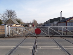
Turn right to continue straight on eastwards down this road as it drops downhill. After a quarter of a mile it ends at a T-junction with the B5057 road in Darley Bridge. Turn left and follow the road as it curves around to reach the bridge over the Wye that was crossed earlier. Continue along the road as it winds around in a rough northerly direction across the floodplain using the pavement on the left-hand side of the road. After half a mile a level crossing is reached at Darley Dale station. Pass the station, and after twenty yards turn right to cross the road and join a footpath that runs with a wall on the right and fence on the left. The wall soon becomes a fence; continue along the path as it passes a railway yard on the right for a fifth of a mile, when the path climbs up some steps to reach a bridge over the railway.
Turn left to follow the road east. After a fifth of a mile turn right down a short track that leads to a footpath that squeezes between a hedge on the left and a house on the right. The path soon reaches the top of some steps that leads to a pedestrian crossing over the railway line. Turn left to follow the lineside footpath southeastwards for 1.2 miles, goingthrough any gates you meet on the way, until a bridge over the Derwent is reached at SK289605.
The footpath narrows as it crosses the bridge, climbing up onto the top of one of the bridge's side. Once at the northern side of the bridge, turn right and then drop down some steps to meet the path that was walked along earlier. Turn right and follow the path as it heads under the railway bridge. Continue along the path as it follows the river downstream; after 0.7 miles it joins the A6 on the right. Just before a road bridge over the river, turn right across a pedestrian crossing over the road. On the other side turn right to follow the pavement as it curves to the left, passing a large footbridge on the left to reach Matlock railway station at SK296601
 |
 |
|
Distances
| From | To | Distance (m) | Ascent (ft) | Descent (ft) |
|---|---|---|---|---|
| Matlock station | Darley Bridge | 2.5 | 74 | 76 |
| Darley Bridge | Rowsley | 3.1 | 38 | 25 |
| Rowsley | Nine Ladies stone circle | 4.0 | 890 | 209 |
| Nine Ladies stone circle | Darley Dale | 3.8 | 175 | 879 |
| Darley Bridge | Matlock station | 2.6 | 85 | 73 |
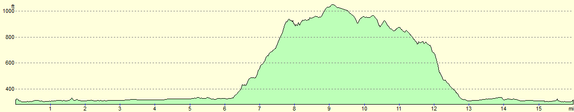
This makes a total distance of 16.0 miles, with 1262 feet of ascent and 1262 feet of descent.
For more information on profiles, ascents and descents, see this page
 |
 |
|
Accommodation
I spent the night at Beech Croft Farm Caravan Park & Camp Site, a lovely caravan and camping site near Taddington. This is a lovely little campsite that is situated just off the A6 between Bakewell and Buxton. They can be contacted on 01298 85330.
 |
 |
|
 |
 |
|
 |
 |
|
 |
 |
|
 |
 |
|
 |
 |
|
 |
 |
|
 |
 |
|
 |
 |
|
 |
 |
|
 |
 |
|
 |
 |
|
 |
 |
|
 |
 |
|
 |
 |
|
 |
 |
|
 |
 |
|
 |
 |
|
 |
 |
|
 |
 |
|
 |
 |
|
 |
 |
|
 |
 |
|
 |
 |
|
 |
 |
|
 |
 |
|
 |
 |
|
 |
 |
|
 |
 |
|
 |
 |
|
 |
 |
|
 |
 |
|
 |
 |
|
 |
 |
|
 |
 |
|
Disclaimer
Please note that I take no responsibility for anything that may happen when following these directions. If you intend to follow this route, then please use the relevant maps and check the route out before you go out. As always when walking, use common sense and you should be fine.
If you find any information on any of these routes that is inaccurate, or you wish to add anything, then please email me.
All images on this site are © of the author. Any reproduction, retransmissions, or republication of all or part of any document found on this site is expressly prohibited, unless the author has explicitly granted its prior written consent to so reproduce, retransmit, or republish the material. All other rights reserved.
Although this site includes links providing convenient direct access to other Internet sites, I do not endorse, approve, certify or make warranties or representations as to the accuracy of the information on these sites.
And finally, enjoy your walking!
Nearby walks
| # | Title | Walk length (miles) |
|---|---|---|
| 11 | Stanton Moor | 2.9 |
| 12 | Darley Dale, Stanton Moor and Rowsley | 8.7 |
| 14 | Friden, Long Dale and Gratton Dale | 7.8 |
|
|

|