Walk #500: Arisaig to Tarbet
 |
 |
|
General Data
| Date Walked | 16/07/2003 |
| County | Highlands |
| Start Location | Arisaig |
| End Location | Tarbet |
| Start time | 09.35 |
| End time | 18.58 |
| Distance | 19.5 miles |
| Description | This was a very varied walk, with a long road plod being followed by a beautiful path along the north bank of Loch Morar. |
| Pack | For the first part of today's walk I carried my 30-litre Karrimor HotRock rucksack, which was filled with my packed lunch, waterproof leggings, water bottle and a couple of spare shirts, together with the usual assortment of odds and ends. for the last part of the stroll to Tarbet I carried my seventy litre Craghoppers rucksack with full camping gear, except I carried a bivvy bag instead of a tent. |
| Condition | I feel absolutely fine after today's walk, and I have no significant problems to report. My neck and right shoulder are again fine for a fit day, which is a good sign. |
| Weather | Today was a very sunny day, with only a few clouds to spoil it. As a consequence of this it got quite hot, and there was not much wind to cool things down. |
| OS map | Landranger number 40 (Mallaig & Glenfinnan, Loch Shiel) |
 |
 |
|
 |
 |
|
Map of the walk
Maps courtesy of Google Maps. Route for indicative purposes only, and may have been plotted after the walk. Please let me have comments on what you think of this new format. For a detailed table of timings for this walk, please see the table file.
 |
 |
|
 |
 |
|
Notes
I woke up feeling slightly fragile this morning - eighty shilling and whisky do not mix very well. I drunk lots of water, and this helped me recover (although I never got a headache, for which I am thankful). I also did not sleep very well last night, as we got attacked by midges that found their way into the van and were getting irritated by the fridge light. Things got better when Sam moved to sleep downstairs (I guess that they attacked her rather than me!), and I finally managed to get back to sleep.
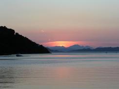
Mallaig was bustling when I arrived, and this only got worse once the steam train arrived and disgorged its load of passengers into the village. Sam and I were hungry, and so we decided to go into the fishermen's mission, opposite the station, for a bite to eat. Fortunately we got there just before the hordes descended, so we did not have to wait too long for our scampi and chips. Mallaig is a curious village - I was full of tourists, and the working harbour seemed to be quite small, but I enjoyed the atmosphere nonetheless. It was nice being able to eat seafood and see a steam train and maroon coaches out of the window, and on a sunny day like this any expanse of water looks beautiful, and the sea around the town was no exception. I am quite glad that I made he diversion into the village (it may have made more sense to walk directly from Morar), and I would not mind seeing the village again sometime. I knew that I would probably not be able to get Internet access for some time, so I spent an hour or so checking emails and doing some general surfing. I was not in too much of a hurry, as I knew that I would be camping or in a bothy and it gets dark late at this time of year.
The walk from Mallag souh into Morar was boring, but in Morar I enjoyed seeing the Jacobite returning to Fort William, with a steam engine at its head. I et a couple who were doing a walk from Arisagig to Mallaig as a practice for the West Highland Way, and tomorrow they are doing the walk from Morar to Tarbet - I have done both of these walks and a little more inn one day, which gives me a rather unhealthy feeling of satisfaction. I met Sam at the end of the road in Bacorina, and I spent an hour with her whilst I packed my rucksack with all the kit needed for the next few days and Sam made me a bite to eat, which was good as it meant that I did not have to cook this morning!
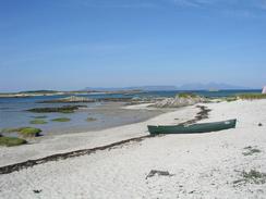
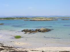
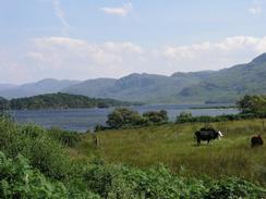
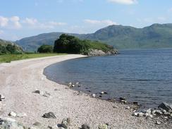
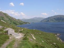
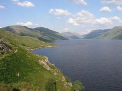
The path along the northern bank of Loch Morar was absolutely fantastic in the sunshine, and I enjoyed my walk along it immensely, although this may well have been different if it had been raining! The path was ascending and descending the whole time, but it was easy to follow and this allowed me to look at the views more than I usually do. The clegs were in good form tonight, and they were proving annoying so I sprayed von Skin So Soft on - this appeared to work, and although I dislike the smell it is better than being bitten.
It had been my intention to spend the night in the bothy that I knew existed at Tarbet - this usually costs one pound fifty for a night. Unfortunately as I was on the path leading along the shores of Loch Morar I came across a couple of ladies who told me that the bothy was ht. I had my bivvy bag with me, but I really did not fancy spending the night in my bivvy bag with all the clegs about. It turns out that Cameron McIntosh, the impresario, is building a castle to replace his house that burnt down at Tarbet, and that the bothy is being used by workmen. It was hence with some trepidation that I approached the old church. Fortunately they could not have been nicer, and they let me stay for the night despite the fact that they were full. They even had a television, which certainly was more than a little luxurious, or at least they did whilst the generator kept going! The lads were all very nice, and I ended up staying up into the early hours, drinking whisky and watching some porn on the satellite system with them - a very strange experience in an ex-Catholic church!
Tomorrow promises to be a very hard day. Ideally I want to reach Inverie, although this will be very hard as the first section to Sourlie is unpathed and shall take me at least four hours for five miles. After this I will have to climb up to over 500 metres before descending down to Inverie.
Directions
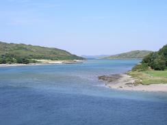
This walk starts off at the campsite at Invercaimb, a couple of miles to the north of Arisaig. Leave the campsite and turn left to head north along the coast road (this used to be the main A830(T) but has been superseded by a new road this year - the new road is not marked on my Ordnance Survey map). The road heads northwards through Portnaluchaig and Glenancross before eventually joining the southern bank of the River Morar for a short distance before joining a roundabout with the A830(T).
At the roundabout turn left to head northwards along the main road. However if you do not want to visit Mallaig then turn right along the B8008 road into Morar. Continue along the AA830(T) northwards for about three and a half miles into the centre of Mallaig to have a look around - there is a good cycle path alongside the road for most of the way, making it a very safe walk, before turning around and heading south for a couple of miles until there is another junction with the B8008 road at grid reference NM675935 and follow the road past Morar Station and over a level crossing.
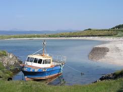
Continue on through the village and then turn left down a road that heads eastwards to the shore of Loch Morar. The road passes a church and then continues along the northern bank of Loch Morar, and there are some superb views over the loch. The road climbs steeply uphill into Bracora before descending into Bracorina, where the road ends. At Bracorina a track follows the bank of the loch eastwards, but the track soon ends and a distinct path continues on along the shore of the loch, climbing up and down past Brinacory before eventually reaching Swordland. Here the path becomes a track (albeit a very indistinct track that looks more like a path) that passes Swordland Lodge and continues eastwards for a few hundred metres, before turning to the left and heading northwards for a little under a kilometre until the church is Tarbet is reached, at the southern end of Tarbet Bay, where this walk ends.
Distances
| From | To | Distance (m) | Ascent (ft) | Descent (ft) |
|---|---|---|---|---|
| Arisaig campsite | Mallaig | 7.7 | 961 | 945 |
| Mallaig | Bracorina | 6.2 | 827 | 774 |
| Bracorina | Tarbet | 5.6 | 1171 | 1227 |
This makes a total distance of 19.5 miles, with 2959 feet of ascent and 2946 feet of descent.
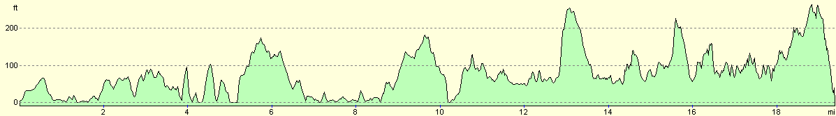
For more information on profiles, ascents and descents, see this page
Accommodation
I spent the night at the Old Church Bothy, which normally costs one pound fifty for a night's stay. Unfortunately it was officially hut when I visited, but I managed to stay anyway. The building is a fantastic little church, with some quite ornate features.
Disclaimer
Please note that I take no responsibility for anything that may happen when following these directions. If you intend to follow this route, then please use the relevant maps and check the route out before you go out. As always when walking, use common sense and you should be fine.
If you find any information on any of these routes that is inaccurate, or you wish to add anything, then please email me.
All images on this site are © of the author. Any reproduction, retransmissions, or republication of all or part of any document found on this site is expressly prohibited, unless the author has explicitly granted its prior written consent to so reproduce, retransmit, or republish the material. All other rights reserved.
Although this site includes links providing convenient direct access to other Internet sites, I do not endorse, approve, certify or make warranties or representations as to the accuracy of the information on these sites.
And finally, enjoy your walking!
This walk was mentioned in the following routes:
| My walk around the coastline of Britain |
Nearby walks
| # | Title | Walk length (miles) |
|---|---|---|
| 499 | Glenuig to Arisaig | 19.4 |
| 501 | Tarbet to Inverie | 17.3 |
|
|

|