Walk #296: Winchelsea Beach to Normans Bay
 |
 |
|
General Data
| Date Walked | 14/12/2002 |
| County | East Sussex |
| Start Location | Winchelsea Beach |
| End Location | Norman's Bay |
| Start time | 07.45 |
| End time | 14.55 |
| Distance | 17.6 miles |
| Description | This was a lovely but surprisingly strenuous days walk, on a very eventful day. |
| Pack | I started off today carrying no pack until I got to Hastings, where I picked up my pack. When I met Sam in Bexhill I dropped it off again, so I ended up carrying the pack for only a short distance today. |
| Condition | I feel exceedingly fatigued after this walk, and I slept for a few hours after dinner this evening (although this may have had more to do with being up since 4.30 this morning). Despite this at the end of the walk I felt as though I could easily have walked further, which is a good sign. My ankle did not give me any significant problems, and although I found the uphill sections hard my legs did not give in. When I met Sam in Bexhill I changed out of my boots and put my trainers on, which probably helped save my feet a little. |
| Weather | The weather today was overcast and grey, and on the tops of the hills I was actually within the cloud layer, which was very low. It rained for a short period whilst I was on the Fire Hills, but the rest of the day remained thankfully dry. It was quite a warm day, but unfortunately I did not see the sun at all during the day. |
| OS map | Landranger number 189 (Ashford & Romney Marsh, Rye & Folkestone) and Landranger number 199 (Eastbourne & Hastings, Battle & Heathfield) |
 |
 |
|
 |
 |
|
Map of the walk
Maps courtesy of Google Maps. Route for indicative purposes only, and may have been plotted after the walk. Please let me have comments on what you think of this new format. For a detailed table of timings for this walk, please see the table file.
 |
Notes
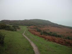
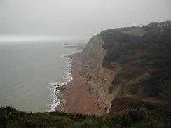
The walk from Fairlight over to Hastings was the most strenuous walk that I have had to do in a fair while. I found it fairly hard, not only due to the steepness of the paths and the fact that the ground was very muddy in places. I had not taken my walking poles with me on this stretch of walk, and so I had to be fairly careful not to slip in places. If the weather had been clear then the views would probably have been fantastic, but unfortunately it was cloudy and misty at the top of the cliffs. The first hill to the west of Fairlight is one of the Fire Hills, and as I was walking across it in the mist I could not help but think of the fourth book of the Douglas Adams Hitchhiker trilogy, where God's last message to creation is written on the side of the fire mountains. The misty weather made me think that this must be the sort of terrain that he had in mind when he wrote the book, and I could imagine large letters scrawled on the cliff face below me.
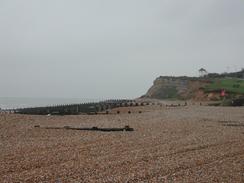
Cliff End is the southwestern end of the Royal military Canal, which runs for twenty-eight miles from Hythe (I pass the starts of it a few days ago). This was another defence against Napolean's armies, and was built between 1804 and 1809 as a canal and a fortification. The canal had gun positions at every 500 yards and a military road ran alongside, protected by an earth bank. With the fall of Napoleon the canal lost its military value, but in the Second World War pillboxes were built along the length of the canal.
Whilst I was walking through the Hastings Country Park to the east of the town I kept on passing into and out of mobile reception. when I was climbing out of Fairlight Glen I received a text message from Sam saying that she had organised for me to do a radio interview with a local commercial radio station, Arrow FM. By the time I got to Hastings and met Sam they were ready to call me back, and so I sat down on a bench that had a lovely view of the pier and did the interview. The interviewer asked how people would recognise me and said that if anyone saw me they should honk their car horns - and therefore as I was walking through Hastings I had six cars honk their horns at me, which was an unusual experience to say the least.
Past the pier in Hastings there are two promenades, the upper one being directly above the lower one. I chose to walk along the upper one that runs beside the road so that I would get better views As I walked along four men who were standing by the railing called me over and asked me of I knew first aid. I asked why, and they pointed to a young man who was lying on the lower promenade ten or twelve feet below. There was a fair amount of blood about and some strange things went through my head - should I go down to help, would I be endangered, what would happen.
The man was not moving and he was on his own, so I decided to go down and see if I could help as he was on his own. My first problem was how to get down - eventually I ran for about a hundred yards to a ramp that lead down to the lower promenade. Running with my pack on must have seemed quite funny to onlookers, as my collection pot was flying about everywhere as it had come loose from my pack and was only attached by a string. when I reached the man I could see a large gash on his forehead and he was holding his side, so I thought that he may have fallen off the upper promenade. It was clear he was breathing, so I shrugged my pack off and knelt down beside him. When I touched his forehead he stirred, and when I asked his name he replied that he was called Tim. Since he was conscious and breathing I did not put him in the recovery position, and chatted to him until the police and paramedics came. He was very vague, and when I asked him how long he had been there he replied 'two months', which I assume was the length of time he had been in Hastings rather than how long he had been lying there, which is what I had meant. One of the two policemen took my details and I then continued on the walk in a very strange mood.
Bexhill was in a party mood, and a brass band was playing in a little marquee. The De La Warr Pavillion in Bexhill had seen better days. It was built in 1935 and was the first sea-front entertainment complex of its kind in the country, but the white paint was flaking and the whole place had a general feeling of neglect. Bexhill held the first ever motor race in this country in May 1902 on a race along the seafront from the Sackville Hotel up to the top of Galley Hill. The races continued until 1907, when the Brooklands circuit opened. The races were restarted in the eighties, and are a tourist attraction for the area.
Directions
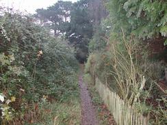
This walk starts off by the beach at Winchelsea Beach. Join the seawall that is beside the beach and follow it southwestwards. After a kilometre a road joins the base of the sea wall and follows it for a couple more miles until the sea wall ends by the cliffs at Cliff End. Before the wall ends turn right past the lifeboat station and pub down onto a road. Turn left down this road past the pub and the end of the Royal Military Canal until a road comes in from the right. A few yards past this road a lane leads off uphill to the left. Beside this lane there is a footpath, signposted the Saxon Shore Way that leads uphill past back gardens until the cliff edge is reached. At the cliff edge the path turns to the right and climbs up to the top of the hill before descending down into the little village of Fairlight Cove.
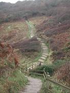
The road alongside the edge of the cliff through Fairlight Cove (called Beach Road) that is marked on my map is no longer walkable as the middle section has fallen into the sea, so I had to make my own way through the village. I headed roughly eastwards, and then had to ask to get my way back onto the cliff path. The cliff path ascends upwards to the west to reach a coastguard station on the Fire Hills, before descending into a valley, climbing up and then descending into Fairlight Glen. It then ascends once more before descending into Ecclesbourne Glen. Navigation is easy on these stretches as the paths are wide and they are well waymarked; just follow the sings for Hastings. The path rises for one last time onto the top of East Hill before descending past the cliff railway down to a car park by the tourist information centre in Hastings.
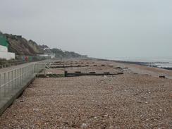
In Hastings follow the seafront westwards towards and past the pier. From the pier the promenade is on two levels, with the lower one actually being directly below the upper one. Continue on as the promenade enters St Leonards until it ends, when I joined the beach and followed it westward through West Marina. The railway line runs alongside the beach as it passes Glyne Gap. When a hill starts to ascend on the right follow a path that climbs up onto the top of Galley Hill before descending down into Bexhill. At the bottom of the hill join the promenaded and follow it through Bexhill until it ends on the western side of the town.
When the promenade and sea wall ends continue on along the beach towards Cooden Station. Here a road parallels the coastline, and gives a easier walk than along the beach for a mile. When the road curves to the right to cross over the railway line on a level crossing turn to the left to rejoin the beach and follow it for another mile into Norman's Bay. In Normans Bay turn right and follow a road up to the station, where this walk ends.
Distances
| From | To | Distance (m) | Ascent (ft) | Descent (ft) |
|---|---|---|---|---|
| Winchelsea Beach | Hastings Pier | 8.9 | 1352 | 1345 |
| Hastings Pier | Normans Bay | 8.7 | 256 | 259 |
This makes a total distance of 17.6 miles, with 1608 feet of ascent and 1604 feet of descent.
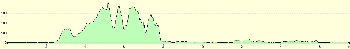
For more information on profiles, ascents and descents, see this page
Accommodation
We stayed in the overflow car park of the Star Inn, who kindly let us stay there for the night. This was a very nice pub and we had a few pints in it during the evening to while away the time.
Disclaimer
Please note that I take no responsibility for anything that may happen when following these directions. If you intend to follow this route, then please use the relevant maps and check the route out before you go out. As always when walking, use common sense and you should be fine.
If you find any information on any of these routes that is inaccurate, or you wish to add anything, then please email me.
All images on this site are © of the author. Any reproduction, retransmissions, or republication of all or part of any document found on this site is expressly prohibited, unless the author has explicitly granted its prior written consent to so reproduce, retransmit, or republish the material. All other rights reserved.
Although this site includes links providing convenient direct access to other Internet sites, I do not endorse, approve, certify or make warranties or representations as to the accuracy of the information on these sites.
And finally, enjoy your walking!
This walk was mentioned in the following routes:
| My walk around the coastline of Britain |
Nearby walks
| # | Title | Walk length (miles) |
|---|---|---|
| 295 | Dungeness to Winchelsea Beach | 17.1 |
| 297 | Norman's Bay to Beachy Head via Eastbourne | 10.8 |
|
|

|