Walk #336: Polperro to Penpoll
 |
 |
|
General Data
| Date Walked | 24/01/2003 |
| County | Cornwall |
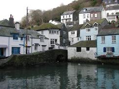
| Start Location | Polperro |
| End Location | Penpoll |
| Start time | 09.45 |
| End time | 16.10 |
| Distance | 13.1 miles |
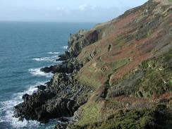
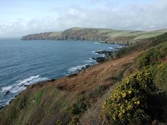
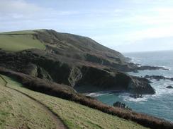
| Description | This was a long and enjoyable walk of two halves; an initial stroll along a strenuous yet scenic stretch of coast path which was followed by a long walk along footpaths and roads up the eastern bank of the River Fowey. |
| Pack | Today I carried my 30-litre Karrimor HotRock rucksack, which was filled with my packed lunch, waterproof leggings, water bottle and a couple of spare shirts, together with the usual assortment of odds and ends. |
| Condition | I found the ascents and descents of the early stretch of this walk quite hard, and for a while I felt nauseous when I was working hard on the ascents. I am unsure what caused this, but it may have been something to do with swallowing water and chlorine in the pool this morning. By lunchtime I was feeling better, although still far from perfect, and this remained the case for the rest of the day. To make matters worse, about half an hour from the end of the walk whilst walking along the road my bad ankle started hurting, and it continued hurting when I was in the van this evening. This is distinctly worrying, and particularly as I do not know what I did to cause it to start hurting. |
| Weather | The weather today was a combination of cloud and sunshine, which led to quite a nice day. It was also fairly warm, especially when the sun was out, and there was not much wind to cool me down. There was no sight of any rain, which I was thankful for as I worked my way up and down the steep paths. |
| OS map | Landranger number 201 (Plymouth & Launceston, Tavistock & Looe) and Landranger number 200 (Newquay & Bodmin, Camelford & St Austell) |
 |
 |
|
 |
 |
|
Map of the walk
Maps courtesy of Google Maps. Route for indicative purposes only, and may have been plotted after the walk. Please let me have comments on what you think of this new format. For a detailed table of timings for this walk, please see the table file.
 |
 |
|
 |
 |
|
Notes
I had a late start today, as I used the fact that we had mains power to the van to allow me to do a little work on the computer. I also could not resist having a swim in the indoor swimming pool at the park, so when it opened at 08.30 Sam and I went to it for an enjoyable half hour. This was a really nice diversion, as I have not been swimming for months now.
At lunchtime I nipped into the Russell Inn in Polruan so that I could use their facilities. I stated chatting to the landlord, and he took a great interest in what I was dig and gave me a free pint, which was very gratefully received. I chose a pint of Cockle Roaster, which was very nice and went down easily as we chatted. Polruan itself was a quite attractive little town, and I went down to the quay to look ou over the water towards Fowey on the other bank.
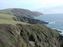
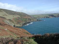
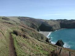
I really should not have found the coastal sections of this walk as hard as I did, but I struggled up and down the hills as can be seen by my times over this section. It did not look as though it was a massively hard walk, but I found it exceedingly so. I felt slightly better when we met a couple in the pub this evening who had walked around the coast path I Cornwall, and they said that today's section was one of the hardest, and I do not feel any need to argue with them about that. The fact that I was feeling ill also did not help me find the walk easy.
As I walked through the pretty woodland past Fowey on the opposite bank of the river, I could see ships loading with china clay, and in the distance white-toped hills, which I assume were large mounds of china clay. China clay has very much taken over from tin mining as being the main primary industry in Cornwall, and it is a major export from the area, and appears to be increasingly so now that tin mining has effectively died out.
I met an American couple on the descent down into the valley Pont Pill. I chatted to them for a few minutes, and it turns out that they were spending a few months in Cornwall and had walked the entire South West Coast Path. It turns out that where they live is only a few miles away from the Allapacian Trail, and I commented that that trail is much harder than the SWCP. They disagreed, and said that some sections of the South West Coast Path (for instance the section past Morwenstow on the north coast) were much harder than t3he sections of the Allapacian Trail that they had done. This surprised me, as I had always thought of the Allapacian Trail as being a incredibly hard walk when compared even to the longer walk that I am currently doing.
'Pol' features a lot in today's walk, as I started off in Polperro, I walked through Polruan and I ended in Penpoll. There are also various other Pols spread about in this area, and this makes me wonder exactly what is stands for. The Cornish influence on place names is now becoming far more common, and I am expecting the English influence to reduce as I get nearer to Lands End.
This evening we went to the Ship Inn in Lerryn, and we had a drink whist we relaxed for a while - Sam was wound up after driving the van down these nasty narrow lanes. We did a collection around the pub and got a nice amount of money, and as I was feeling tired I went to bed whilst Sam finished off the collection. It was quite an enjoyable evening, and I eel much more relaxed after it.
Directions
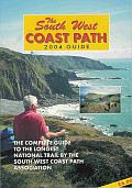
| During this walk I followed the South West Coast Path, the route of which is detailed in the Ordnance Survey National Trail Guide 10, Falmouth to Exmouth (ISBN 1-854108-90-5). Unfortunately the route description is written in reverse to the direction that I am walking, but the 1:25,000 maps in the book are clear and the signs on the ground are very good. Also to be recommended is the South West Coast Path Association guidebook (ISBN 0-907055-04-4), which has less concise directions and no maps, but includes accommodation details and grades each section of the walk according to difficulty. They also publish reverse directions, which are suitable for walking in the direction that I walked the route. They have a website at www.swcp.org.uk, which is well worth a visit. | 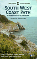
|
| 
| |
| |
| |
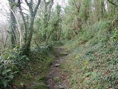
The second part of this walk, from Polruan to Penpoll, is along a combination of footpaths and roads. Walk northeastwards through Polruan before taking a footpath called the Hall Walk that leads through woodland on th3e south bank of the Pont Pill Creek. The path meets a road but does not join it, choosing instead to skirt the road as it descends down to a footbridge across the end of the creek.
Cross the footbridge and take a footpath that rises up the hillside ahead, signposted Bodinnick. When this footpath emerges from the woodland into a field turn to the left and skirt the edge of the field for a hundred yards before the footpath plunges back into the woodland. When the path reaches a monument with some lovely views over the Fowey estuary the path turns to the right and passes another monument before descending down to a road in Boddinick.
Turn left and descend down to the ferry landing in the village. Follow the road as it turns to the right and passes a toilet block before climbing uphill out of the village. When an area of woodland ends on the left after a short distance take a footpath that leads off to the left, descending a hill and crossing a concrete road and later a stream before skirting the edge of a field beside Mixtow Pill and reaching the little hamlet of Mixtow. When the footpath ends at a road turn right up this road and follow it uphill. At a T-junction head straight uphill for another hundred yards and then follow the road as it curves to the right. After another few yards take a road to the left that heads uphill before ending at a T-junction with a larger road. Turn left down this road and follow it for the short distance into Lanteglos Highway. Take the first road to the left that descends steeply down a narrow road before reaching the end of Penpoll Creek in Penpoll, where this walk ends.
Distances
| From | To | Distance (m) | Ascent (ft) | Descent (ft) |
|---|---|---|---|---|
| Polperro | Polruan | 7.4 | 2520 | 2549 |
| Polruan | Penpoll | 5.7 | 1371 | 1417 |
This makes a total distance of 13.1 miles, with 3891 feet of ascent and 3966 feet of descent.
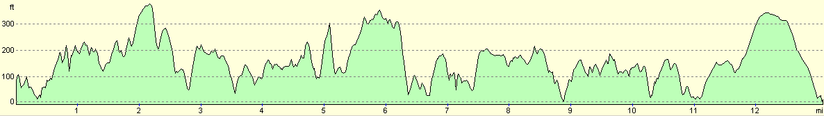
For more information on profiles, ascents and descents, see this page
Accommodation
Penpoll was a very small place, so we decided to drive for a couple of miles north over the hills to Lerryn, where we parked in a delightful spot beside the river. When we arrived Sam and I walked onto the stepping-stones over the river and fed the ducks with some bread, which was a fairly normal experience that made for a lovely and memorable few moments.
Disclaimer
Please note that I take no responsibility for anything that may happen when following these directions. If you intend to follow this route, then please use the relevant maps and check the route out before you go out. As always when walking, use common sense and you should be fine.
If you find any information on any of these routes that is inaccurate, or you wish to add anything, then please email me.
All images on this site are © of the author. Any reproduction, retransmissions, or republication of all or part of any document found on this site is expressly prohibited, unless the author has explicitly granted its prior written consent to so reproduce, retransmit, or republish the material. All other rights reserved.
Although this site includes links providing convenient direct access to other Internet sites, I do not endorse, approve, certify or make warranties or representations as to the accuracy of the information on these sites.
And finally, enjoy your walking!
This walk was mentioned in the following routes:
| My walk around the coastline of Britain |
| South West Coast Path |
Nearby walks
| # | Title | Walk length (miles) |
|---|---|---|
| 335 | Freathy to Polperro | 16.0 |
| 337 | Penpoll to Fowey | 15.6 |
|
|

|