Walk #366: Steart to Highbridge
 |
 |
|
General Data
| Date Walked | 24/02/2003 |
| County | Somerset |
| Start Location | Steart |
| End Location | Highbridge |
| Start time | 07.37 |
| End time | 17.22 |
| Distance | 25.2 miles |
| Description | This was a very long and flat walk, at the end of which I have not ended very far from where I started in the first palace due to an enforced walk down the Rive Parrett to Bridgwater. |
| Pack | Today I carried my 30-litre Karrimor HotRock rucksack, which was filled with my packed lunch, waterproof leggings, water bottle and a couple of spare shirts, together with the usual assortment of odds and ends. |
| Condition | I am very fatigued after this walk, as is to be expected after such a long stroll. The underside of my feet ache, partly because much of today was on stony ground, and maybe because they got sore yesterday. Aside from these complaints I am fine, and am not showing any major effects of the walk. |
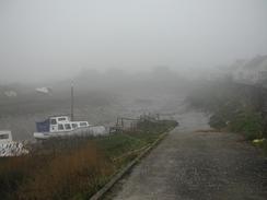
| Weather | The morning started off very foggy, and it took a few hours for all of this to burn off. It was replaced with low cloud, and although it never rained my feet got damp from all the dew on the grass. Later on there were a few short sunny periods, although clouds dominated the day. It was a reasonably warm day, but any benefit from this was removed by the quite strong and colder wind. |
| OS map | Landranger number 182 (Weston-super-Mare, Bridgwater & Wells) |
 |
 |
|
 |
Map of the walk
Maps courtesy of Google Maps. Route for indicative purposes only, and may have been plotted after the walk. Please let me have comments on what you think of this new format. For a detailed table of timings for this walk, please see the table file.
Notes
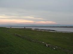
I found this walk to be quite boring, and in a way reminiscent of the long estuary walks that I had to do in Suffolk and Essex. I was also quite keen to get a long distance walked today whilst the going is flat, so I am exceedingly pleased that I have managed to walk over twenty-four miles - the longest distance that I have walked for some time. I did not take many photographs today, due jointly to the foggy start - visibility was very limited for the first few hours - and the fact that there was not much to photograph as the scenery was fairly boring.
the going underfoot was fairly easy for much of the way, and the most annoying thing was that there were no tiles at many of the gates, which meant that I was forced to climb over the gates. In places the ground was fairly badly rutted, and this meant that I had to be slightly careful to avoid twisting my ankles. Having said this, even where it was rutted the path was far better than many sections of the South West Coast Path.
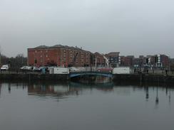
I met Sam in Bridgwater and we went to the local library together so I could check my emails. This was made difficult by the fact that the computer annoyingly kept on crashing whenever I got to the message that I wanted to reply to. Eventually I gave in and we went to a nearby pub for a quick drink - mine was a lovely pint of 6X.
In the middle of the afternoon I had a phone call from BBC Radio Somerset Sound, who wanted to do my daily interview. The wind was bowing very strongly at the time, so I asked them to phone me back in five minutes. I spent that time walking on and looking for some shelter, but in the end I was forced to lie on my front at the bottom of the riverbank to get all the sound of the wind away from the microphone. The interview went well, and the presenter seems to be genuinely interested in what I am doing, which always helps.
We had a nice email from someone in Peterhead who has offered us a night's free accommodation and meals when we get up there later on in the year. The accommodation sounds extremely nice, and this is yet another example of how nice people are being to us on this trip. Kindness such as this makes the trip so much nicer, and reminds me of the inherent generosity of many people.
Directions
This walk starts off at the car park in the little village of Streat, on the western bank of the River Parrett. Leave the car park and turn left to head eastwards down a road for a few yards, before turning to the right down a track that also carries the River Parrett Trail. The track continues on along for about a mile in a roughly southerly direction, before ending at the riverbank. Turn tight and follow the trail as it curves around, eventually heading under some power lines and reaching the village of Combwich. In the village join the road and pass the Anchor Inn before the road curves to the right along the northern bank of a little tributary. When the road ends at a T-junction turn to the left to cross the stream and then turn left down the other bank. Follow the obvious River Parrett Trail symbols to gain the riverbank once more n the southern side of the little tributary.
Follow the riverbank as it heads in a rough southerly direction. After a little more than a mile the River Parrett Trail heads off to the right, but a footpath continues on along the riverbank. Once the trail has left the bank the river becomes much rougher, and there are no stiles, which meant that I had to climb over the gates on the path. At times the footpath marked on the OS map moves inland slightly from the bank, but I continued along the bank as this was the path of least resistance. Eventually the path curves around past Dunball on the opposite bank before heading southwards under another set of power lines and continuing on into Bridgwater.
There is a new road bridge over the river at about grid reference 300380 that can be used to cross the river and is not marked on my map, but I continued on down to the first bridge actually in the town, which has an old railway bridge immediately upstream of it. Cross the bridge and then turn left along a road that heads northwards past a tile and brick museum before it ends at the A38 road. Turn left to head north along the road, beside which there is a pavement, for a short distance until a petrol station is reached on the right. Here a gate on the left leads through to the top of the new flood defence bank, on top of which runs a nice stone path.
The path follows the top of the riverbank until it approaches some industrial building straight ahead in Dunball. Just before these buildings are reached cross a gate and immediately on the other side take a stile down to the right that leads down to the adjacent A38 road. Join the pavement beside the road and turn left to head northwards, crossing a bridge before reaching a stone yard on the other side of the bridge. Here the map shows a footpath leading of to the left to rejoin the riverbank, but I could not find this path - if you can find it then use it. I walked on along the A38, passing straight on over a roundabout before taking a track off to the left just before a car showroom is reached. This track heads westwards for a little under a kilometre before ending at the riverbank.
Turn right to walk northwards along the riverbank. The footpath on top of this bank an be followed for eight or nine miles as it passes around Pawlett Hams and crosses the Huntspill River before turning eastwards into the town of Highbridge. The path is easy to follow; just keep the river and the sea on your left. At first it appear as though you cannot cross the sluice over the Huntspill River, but there is a narrow path that squeezes past the building on the sluice. The walk ends at the bridge beside the A38 in Highbridge, although there is a bridge that can be crossed a few hundred yards downstream of this bridge if you do not want to visit the town.
Distances
| From | To | Distance (m) | Ascent (ft) | Descent (ft) |
|---|---|---|---|---|
| Steart | Bridgwater | 11.2 | 138 | 151 |
| Bridgwater | Highbridge | 14.0 | 171 | 171 |
This makes a total distance of 25.2 miles, with 309 feet of ascent and 322 feet of descent.
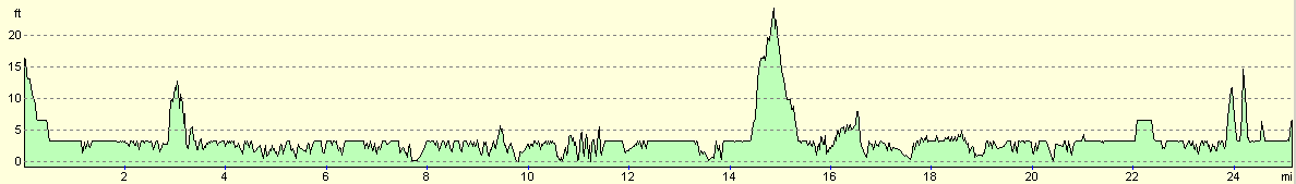
For more information on profiles, ascents and descents, see this page
Accommodation
We parked in a car park in Highbridge that was convenient for the local pubs and shops, and did not cost us anything, which was nice. We may look at getting a campsite tomorrow night, but I am unsure about this a we would only have been out for three days from the last time we stayed at a site.
Disclaimer
Please note that I take no responsibility for anything that may happen when following these directions. If you intend to follow this route, then please use the relevant maps and check the route out before you go out. As always when walking, use common sense and you should be fine.
If you find any information on any of these routes that is inaccurate, or you wish to add anything, then please email me.
All images on this site are © of the author. Any reproduction, retransmissions, or republication of all or part of any document found on this site is expressly prohibited, unless the author has explicitly granted its prior written consent to so reproduce, retransmit, or republish the material. All other rights reserved.
Although this site includes links providing convenient direct access to other Internet sites, I do not endorse, approve, certify or make warranties or representations as to the accuracy of the information on these sites.
And finally, enjoy your walking!
This walk was mentioned in the following routes:
| My walk around the coastline of Britain |
Nearby walks
| # | Title | Walk length (miles) |
|---|---|---|
| 365 | Watchet to Steart | 17.3 |
|
|

|