Walk #397: Cwrt to Fairbourne
 |
 |
|
General Data
| Date Walked | 28/03/2003 |
| County | Gwynedd |
| Start Location | Cwrt |
| End Location | Fairbourne |
| Start time | 08.52 |
| End time | 17.02 |
| Distance | 22.3 miles |
| Description | This was a long walk, mostly along roads but also including a little amount of beach walking. |
| Pack | Today I carried my 30-litre Karrimor HotRock rucksack, which was filled with my packed lunch, waterproof leggings, water bottle and a couple of spare shirts, together with the usual assortment of odds and ends. |
| Condition | I feel absolutely fine after this walk, and have had no significant problems aside from a slight ache in my bad ankle at the end. I could easily have walked further if I had needed to. |
| Weather | The day started off sunny, and as the day went on it started to get more cloudy. There was a little bit of wind about early on, but either it died down or I did not notice it. Late on there was a small amount of the forecast rain in the air, but this was not enough to get me even damp. |
| OS map | Landranger number 135 (Aberystwyth & Machynlleth) and Landranger number 124 (Dolgellau & Porthmadog) |
 |
 |
|
Map of the walk
Maps courtesy of Google Maps. Route for indicative purposes only, and may have been plotted after the walk. Please let me have comments on what you think of this new format. For a detailed table of timings for this walk, please see the table file.
Notes
There was a great deal of road walking to be done today, and I only had a relatively small beach section to do between Aberdovey and Tywyn. Despite this I quite enjoyed this walk, and the roads were geneally quiet and not too dangerous, which was a big change from some of the road that I walked along yesterday.
I met Sam three time during the day; I stopped with her in Aberdovey and watched people sunbathing on the beach. The view across the estuary was lovely, and I fund it hard to tear myself away and start walking again. I also met her in Tywyn, where I had decided to stop for lunch. Sam had been having a little tidy up and we had five or six pairs of bots and shoes that we were not using regularly and she wanted to put into the top box. Sam climbed up onto the top of Mervan and I passed them up to he one at a time. This has freed up much space under Mervan, and will allow us to store some more important items under there. We then went out to find a pub, but we could not find one - the only pub on the seafront was apparently in a very dinghy hotel that we did not want to enter. We therefore sat on the seawall an ate my sandwiches, and we saw two or three dolphins swimming about fifty yards offshore - my first proper sighting of a dolphin on this walk. The last time that I met Sam was by the post office in Llwyngwril, where she had me meet the owner, who wanted to take a photograph of me.
I did another little naughty today, as I did not fancy doing the diversion around Broad Water and crossed using the rail bridge instead. I had none of the compulsive reasons that I had yesterday to walk across the rail bridge over the Dovey Estuary, but I decided to cross it anyway just to save the walk. This is illegal and potentially dangerous, but I felt that it was better than the alternative. When I reached the bridge I found that there was some six-foot tall palisade fencing around it, and this stretched a long way into the distance away from the bridge. If I was going to cross the bridge then I had to climb over this fencing; I looked at the problem and then eventually found a place where there was a coping stone that I could use as a step up so that I could swing my leg over the top of the fence and put my foot on the inside horizontal railing. The vertical rails are sharpened into spikes, and so I really did not want to slip at this stage as I could easily have lost the chance to have any children in the future. I got my other foot onto the railing, and then I had to jump the six feet down onto the other side of the fence. This is obviously not a manoeuvre that everyone could or should do, but I quite enjoyed it. I looked both ways up and down the line and once I had convinced myself that it was clear I ran across the bridge, the boards bouncing worryingly underfoot as my feet hit them. On the other side there were two teenagers playing on the line, and the fencing was more conventional, and there was a gap that allowed me to get onto the road.
I planned to stop the walk at Gorsafawddachaidraigodanheddogleddollonpenrhynareurdraethaceredigion Station, and I met Sam in the car park by the station. After I had been stopped for a few minutes I decided to walk up to the top of the spit and back again, but before I could set off a tarmac paving machine came in and started laying tarmac over a hole in the ground. A lady also came out and told us that we could not park in the car park as it was private and belonged to the golf club. We therefore decided to move away from the park, and I walked up to the car park at the top of the spit, and by the time that I reached there the lovely smell of frying bacon was coming from Mervan.
Tomorrow I have to cross the Barmouth railway bridge to cross the Mawddach estuary. Fortunately this bridge also has a public footpath beside it, so I can cross it without danger or worry, unlike those that I did today and yesterday. I am unsure about how far I shall reach tomorrow - it will be nice to get as far as Harlech, although I may be able to get further than that.
Directions
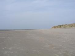
This walk starts off by the A493 road in the little village of Cwrt, about four miles west of Machynlleth. The first part of this walk is very simple; just walk for six miles west along the A493 road into Aberdovey. The road is not too busy, and there were occasional good views along the Dovey Estuary, and this meant that the walk was nowhere near as bad as yesterday's along the A487(T) on the southern side of the estuary. Walk through Aberdovey towards the station, and then join the beach. Walk along the beach beside the sand dunes towards the mouth of the river, and then follow it as it turns to the right to head northwards for a little less than three miles until Tywyn is reached.
In Tywyn either continue northwards along the beach or join the promenade and walk along that instead. Continue on through the town, and when the promenade ends join the shingle beach and continue northwards. Pass the outfall from a sluice and when the beach starts to diverge from the railway line head back inland towards the line, where a track can be followed north alongside it.
When the railway meets the mouth of Broad Water it crosses the water on a short bridge, and here there is a choice. You can either follow a footpath that heads under the Railway Bridge and leads eastwards along Broad Water and the Afon Dysynni to the A493 road bridge, the first crossing that is a public right of way. This is a long diversion, and an alternative to this is to cross using the railway bridge. This is trespassing and potentially dangerous, but the only thing stopping this being done is the palisade fencing on the southern side of the bridge. This fencing was high, but it was just possible for me to climb over it, and on the other side there is more conventional fencing that had a convenient gap in it.
On the other side of the bridge join a road that runs north alongside the railway line past Tonfanau Station, after which the road diverges away from the railway line and head inland around the hill of Bwlch. The road ends at a T-junction with the A493 road, at which you turn left along the A493 road westwards back towards the coast past the northern flank of Bwlch. It then turns to the right to head northwards for about three miles to the village of Llwyngwil before continuing on northeastwards along the flank of Gallt Ffynnon yr Hydd above the railway line. As the road approaches Fairbourne it starts to descend into Friog, and as it does so take a road that leads off to the left. This road heads under the railway line before turning sharply to the right, to head northwards beside the seawall into Fairbourne. The road crosses over the narrow gauge railway line of the Fairbourne railway and continues on northwards, passing Gorsafawddachaidraigodanheddogleddollonpenrhynareurdraethaceredigion Station before heading on to the northern tip of the spit, which is where this walk ends.
Distances
| From | To | Distance (m) | Ascent (ft) | Descent (ft) |
|---|---|---|---|---|
| Cwrt | Aberdovey | 5.9 | 955 | 997 |
| Aberdovey | Tonfanau | 6.8 | 95 | 89 |
| Tonfanau | Fairbourne | 9.6 | 1145 | 1175 |
This makes a total distance of 22.3 miles, with 2195 feet of ascent and 2261 feet of descent.
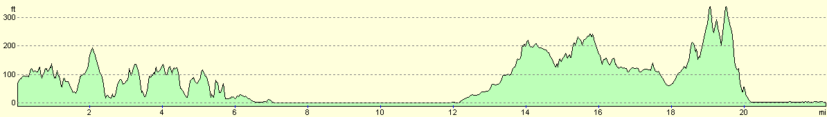
For more information on profiles, ascents and descents, see this page
Accommodation
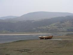
We parked the van in the car park at the end of the spit in Fairbourne. There were absolutely no facilities here, and there was a sign prohibiting overnight parking, but the views over the Mawddach Estuary were sublime, with the mountains reflecting in the water, and the Barmouth bridge in the distance.
Disclaimer
Please note that I take no responsibility for anything that may happen when following these directions. If you intend to follow this route, then please use the relevant maps and check the route out before you go out. As always when walking, use common sense and you should be fine.
If you find any information on any of these routes that is inaccurate, or you wish to add anything, then please email me.
All images on this site are © of the author. Any reproduction, retransmissions, or republication of all or part of any document found on this site is expressly prohibited, unless the author has explicitly granted its prior written consent to so reproduce, retransmit, or republish the material. All other rights reserved.
Although this site includes links providing convenient direct access to other Internet sites, I do not endorse, approve, certify or make warranties or representations as to the accuracy of the information on these sites.
And finally, enjoy your walking!
This walk was mentioned in the following routes:
| My walk around the coastline of Britain |
Nearby walks
| # | Title | Walk length (miles) |
|---|---|---|
| 396 | Aberystwyth to Cwrt | 19.9 |
| 398 | Fairbourne to Harlech | 17.8 |
| 741 | Glyndwr's Way: Llwynygog to Forge | 18.9 |
|
|

|