Walk #465: Dunoon to Ardtaraig
 |
 |
|
General Data
| Date Walked | 07/06/2003 |
| County | Strathclyde |
| Start Location | Dunoon |
| End Location | Ardtaraig |
| Start time | 09.26 |
| End time | 17.06 |
| Distance | 20.6 miles |
| Description | This was an extremely strenuous but rewarding walk, with a very long road section being followed by a short but difficult section of path. |
| Pack | Today I carried my 70-litre rucksack for the first time on this trip, and I carried my tent, sleeping bag, mat and trainers or boots in it. It was not full weight, as I did not carry my spare clothes, cooker or any food, but it was heavy enough for a first trial. |
| Condition | I am very fatigued after this walk, and I got very hot in the latter tough sections of the walk. My feet feel much better than they did yesterday, which I am quite thankful for. |
| Weather | There was some heavy rain first thing this morning, so we delayed the start of the walk slightly. This was a good thing, as the rest of the day was dry and sunny for most of the time. It got quite hot later on in the afternoon, and the wind that there had been earlier in the day had died out. |
| OS map | Landranger number 63 (Firth Of Clyde area) and Landranger number 56 (Loch Lomond & Inveraray) |
 |
 |
|
 |
 |
|
Map of the walk
Maps courtesy of Google Maps. Route for indicative purposes only, and may have been plotted after the walk. Please let me have comments on what you think of this new format. For a detailed table of timings for this walk, please see the table file.
 |
 |
|
 |
Notes
Today was very much an experiment, as for the first time on this trip I used my 70-litre rucksack instead of my 30-litre daysack. In a few weeks I am going to have to start camping out (or even earlier than this if I walk around Arran), and so I am planning to start increasing the weight that I carry so that my body an get used to it. Today was the first phase of this; I did not carry full camping equipment as I left out my Trangia, fuel, and spare clothes, but it was far heavier than the pack that I have usually carried. At first I found the extra weight quite difficult and after only half a mile both of my ankles were aching, but this soon eased off as I got into my stride. One of the strangest things that I had forgotten about was how much the wind catches the larger pack; as I walked down the A815 road to Toward Lighthouse there was a stiff headwind, and when this caught my rucksack from the side it would blow me around slightly until I learnt to cope with this. Considering how much extra weight I was carrying I coped admirably well, my shoulders do not ache overly and I managed over twenty miles, some of it over rough terrain. Tomorrow I shall use my 30-litre rucksack again, as there promises to be some very rough terrain early on as I will have to struggle through a forested area on the western side of the loch with no paths, so a smaller pack will definitely prove useful.
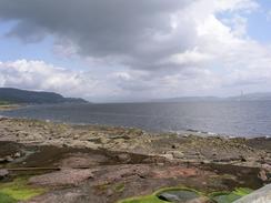
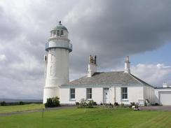
When I reached Toward Lighthouse I could see the Isle of Bute properly for the first time on the trip; previously near Skelmorie it had been obscured slightly by the Great and Little Cumbrae Islands. Reaching Toward Point also meant that I left the Firth of Clyde, which I have been following on and off for over a week. The lighthouse itself was quite nice, and was far more picturesque than it's sister lighthouse at Cloch Point on the eastern side of the Firth.
From Toward Point I turned to walk westwards along the road towards Toward Quay, and the adjacent impressive entrance gateway to Castle Toward. From here I had a choice; I could either continue along the road, which diverted inland, or I could follow a track through an area that used to be used by Sir Robert McAlpine in the sixties and seventies for making oil rigs. I chose to do the latter, and on the way down the track I met a gent who was out walking his dog. We chatted for a while, and he told me that often the gate onto the old site is locked, and of an alternative route. By the time that I reached the gate it was open, and I chose to ignore the trespass notices and walked along the track past some old basins to Ardyne Point. Here I turned to head northwards along the eastern bank of Loch Striven.
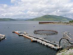
A short distance along the loch from Ardyne Point I reached the obvious signs of a fish farm; big wire cages out in the loch and a plethora of smaller boats nearby. The farm is based on the old construction site, and I was quite interested in looking at everything as I passed the farm. In particular close to the shore there were a couple of round tanks full of what must have been mature fish, and the surface of the water seemed to be alive with salmon leaping. It was an arresting sight, and I stopped to watch them for a few minutes, as the water appeared to boil with the movement of the fish.
A little further on I passed an area that is marked as a jetty on the Ordnance Survey map, but when I got there I found that it was a Scottish NATO POL Depot (POL stands for Petroleum, Oil, Lubricants), yet another sign of the large military presence in the area. The jetty was packed with refuelling rigs, and was itself an impressive structure. There was no ship at the jetty, which was a shame as I would not have minded seeing one.
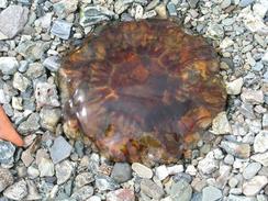
Yet further on I found a lovely spot to sit down on some large stones beside the road, take my rucksack off and eat my lunch. I got a great view down the Loch, with only the occasional car passing me and disturbing the solitude and quiet. Once I had started walking once again I soon met three cars parked beside the road, and some men were loading some scuba gear and large bags of oysters into the cars. I chatted to them for a few minutes about scuba diving before heading on. Later on I came across a couple of signs stating that the shellfish in this loch should not be eaten due to pollution, so I can only hope that the divers knew that!
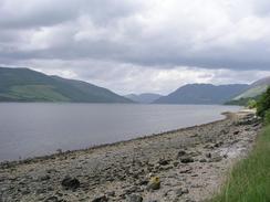
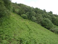
When the road ended I changed from my trainer into my boots because the next section of path beside the loch was quite muddy. After a short distance a good track was joined, and this was nice to follow until I reached The Craig. From here there is a track marked on the map heading northwards along the side of the loch, but although the path was marked on the map I found it very hard to find on the ground. I floundered about for about fifteen minutes in the right direction before I finally came across the path. This was in places quite indistinct on the ground, but it did allow me to make faster progress. The going was really quite strenuous and the afternoon was getting quite warm, and so I started overheating quite quickly. It was with some relief that I reached the road at Ardtaraig, and just as I was looking to find somewhere to sit down Sam arrived, and so I bundled myself into Mervan for the journey back to Dunoon.
Tonight we went out again for a meal with Colin and Susan, who had been out for a walk with Sam to Ardgartan during the day. They had booked an Indian restaurant for the evening, and Colin kindly picked us up for the long drive to the restaurant, which was on the far northern side of Dunoon. The meal was lovely, and the company was also great. Colin and Susan will be leaving tomorrow, and we shall both miss them - it has been great seeing people from Cambridge once again.
Directions
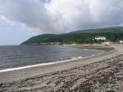
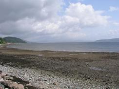
This walk starts off about a hundred yards north of the tourist information office along the A815 road in the town of Dunoon. Head south along the road as it heads beside the coast past the pier and the castle. At the castle continue along the promenade as it heads around to West Bay, where the promenade rejoins the A815 road. Head south along the road, passing through Bullwood and Innellan. After a few miles when the road turns to the right, turn left down a minor road which leads to the lighthouse at Toward Point.
Continue along this road as it curves to the right and heads northwestwards to rejoin the A815 road. Head west along the road for a mile to Toward Quay. Here the road turns sharply to the right, and after about fifty yards a track leads off to the left. Turn left down this track and head westwards along it towards Ardyne Point. Immediately past a bridge over a stream there is a gate; if this gate is locked then it is possible to walk up the eastern bank of the stream to a farm track, which can be used to rejoin the tracks through the old construction yard. If the gate is open (and if you are willing to trespass) then head along the track through an old oilrig construction yard to Ardyne Point. At the point turn right and head north along another track that leads through a fish farm. After a while the track ends, and I had to join the foreshore for a couple of hundred yards before joining the road once again at Port Lamont.
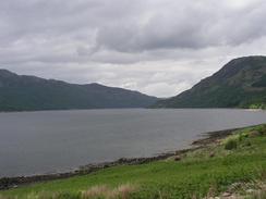
Head north along the road as it heads along the eastern bank of Loch Striven, passing a NATO ship refuelling depot and the church at Inverchaolain. At a jetty to the north of Finart Point the road ends, and a muddy path leads on beside the loch for a few hundred yards before joining another track, which heads north alongside the loch. This passes another jetty and Invervegain, and when the track forks take the left-hand, lower branch. This slowly climbs uphill, and when it doubles back on itself at The Craig take a footpath that heads northwestwards. This path is very indistinct in places but it can be followed fairly easily through the difficult woodland, before it eventually reaches a track at Ardtaraig. This can be followed northwards to a farm, where a path heads uphill steeply to reach the B836 road, where this walk ends.
Distances
| From | To | Distance (m) | Ascent (ft) | Descent (ft) |
|---|---|---|---|---|
| Dunoon promenade | Toward Point | 7.2 | 240 | 236 |
| Toward Point | Inverchaolain | 7.2 | 354 | 302 |
| Inverchaolain | Ardtaraig | 6.2 | 1375 | 1283 |
This makes a total distance of 20.6 miles, with 1969 feet of ascent and 1821 feet of descent.
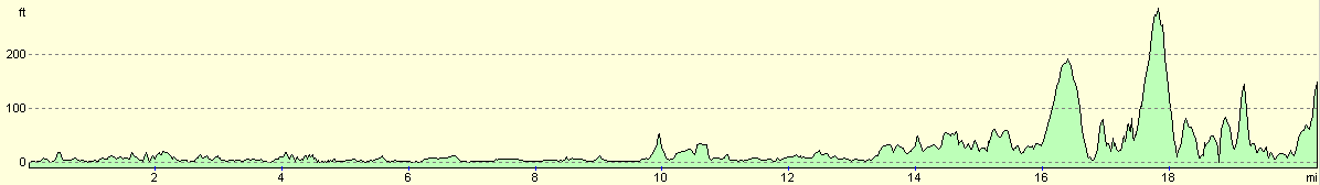
For more information on profiles, ascents and descents, see this page
Accommodation
We parked Mervan in a car park by West Bay, which was handy for the hotel in which our friends were staying in.
Disclaimer
Please note that I take no responsibility for anything that may happen when following these directions. If you intend to follow this route, then please use the relevant maps and check the route out before you go out. As always when walking, use common sense and you should be fine.
If you find any information on any of these routes that is inaccurate, or you wish to add anything, then please email me.
All images on this site are © of the author. Any reproduction, retransmissions, or republication of all or part of any document found on this site is expressly prohibited, unless the author has explicitly granted its prior written consent to so reproduce, retransmit, or republish the material. All other rights reserved.
Although this site includes links providing convenient direct access to other Internet sites, I do not endorse, approve, certify or make warranties or representations as to the accuracy of the information on these sites.
And finally, enjoy your walking!
This walk was mentioned in the following routes:
| My walk around the coastline of Britain |
Nearby walks
| # | Title | Walk length (miles) |
|---|---|---|
| 459 | Fairlie to Fort Matilda | 19.1 |
| 460 | Fort Matilda to Dalreach | 21.1 |
| 461 | Dalreach to Rosneath | 22.2 |
|
|

|