Walk #479: Mull of Kintyre to Tangy Lodge via Machrihanish
 |
 |
|
General Data
| Date Walked | 23/06/2003 |
| County | Strathclyde |
| Start Location | Mull of Kintyre |
| End Location | Tangy Lodge |
| Start time | 09.27 |
| End time | 17.45 |
| Distance | 16.8 miles |
| Description | This was a walk of two halves; a hard walk over the hills north from the Mull of Kintyre was followed by a lovely long beach walk to Westport. |
| Pack | For the first part of today I carried my 30-litre Karrimor HotRock rucksack, which was filled with my packed lunch, waterproof leggings, water bottle and a couple of spare shirts, together with the usual assortment of odds and ends. At Machrihanish I left my rucksack in the van and just wore my coast for the walk along the beach. |
| Condition | I have had a couple of problems today; the minor one was that my left ankle ached a great deal when I reached Machrihanish, but this soon eased; the worst problem was that about half an hour before I reached the town part of my right upper arm went numb and I got some pins and needles in my right hand, which is quite worrying. |
| Weather | Today's weather was very mixed, with some sunshine but also much cloud. It was quite windy, and this meant that the clouds blew over quite quickly. There was one small drizzle shower when I was on the hills, but aside from this the day was dry. |
| OS map | Landranger number 68 (South Kintyre & Campbeltown) |
 |
 |
|
 |
 |
|
Map of the walk
Maps courtesy of Google Maps. Route for indicative purposes only, and may have been plotted after the walk. Please let me have comments on what you think of this new format. For a detailed table of timings for this walk, please see the table file.
 |
 |
|
Notes
"Graham Harbord - great bloke, bad influence!" is what Sam has asked me to write about the events of the last couple of days. We met Graham in Campbeltown at about eight on Saturday night, and what followed was a bender that ended when we finally went to sleep at about four yesterday morning. Because of this no one was in a fit state to drive Mervan back to the Mull of Kintyre, and so I resolved to take another day off. Graham left at about midday, and I walked back north with him as far as Peninver, where we stopped for a drink. He had to walk another nine miles to Caradale, but we were still there at four thirty and five pints later. The last couple of days have been the most drunk that I have been on this trip, and although this has meant that I have taken two days off in a week (one due to my neck and the other due to copious imbibing of alcoholic substances) it was well worth it to spend time with someone who knows exactly what I have been going through for the last eight months. Graham is walking through the pain of bereavement after his wife died of cancer last year, and he is an absolutely superb person - I hope that we shall remain firm friends for a long time.
I woke up quite early this morning without a hangover, which was surprising given the amount of alcohol that I drunk yesterday afternoon. I pulled the blind up and looked out of the window and saw a blue sky, which pleased me greatly as today's walk was going to go quite high and I therefore wanted good weather. Sam woke up later, and we then packed up and drove the long distance to the Mull of Kintyre.
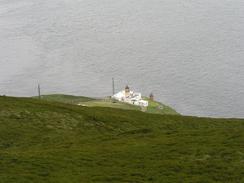
Once we got there I put my pack on and went out the van, and I then saw a man unlocking the gate that guards the steep road that leads down to the Mull of Kintyre lighthouse. I chatted to him for a few minutes, and asked him about the local area and the best route to take over the hills to Machrihanish. He then drove down to the lighthouse, and we descended the short distance to the memorial cairn to the twenty-nine people who died when a Chinook helicopter crashed into the hillside in 1994. The cairn was in a beautiful spot, and we could see the coast of Northern Ireland clearly above the lighthouse, which was far below us on the cliffs. I had a quick prayer in memory of the dead, before we climbed back up to the car park at the top of the Mull.
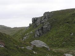
I had been advised that the best route to take to head north was to keep to the high ground. There is no path, but I managed to make reasonable progress by sticking close to a fence that headed northwards across the moorland. I soon got my feet wet when I sunk up to above my ankles in a little stretch of bog that was hidden under some bracken. This set the tone for much of the walk over the trackless but beautiful moorland, and the challenge awakened my senses after the last few weeks, which have predominately been along roads. About an hour into the walk I came across a piece of aluminium - about six feet by three feet and riveted - which was obviously a piece of wreckage of a crashed plane. Many planes have crashed on the hills around the Mull of Kintyre, but there were no obvious signs of any more wreckage in the area. It was as if someone had left it by the fence to be picked up later.
I had been planning to walk up the 446-metre hill of Cnoc May, but as I approached it the top was shrouded in mist, so I decided to skirt around it to the east via Cnocan Biorach and then on northwards. Just before I joined the track near Ballygroggan that leads down to Machrihanish I suddenly felt the upper part of my right arm go numb. I immediately released the right strap of my rucksack to relieve pressure on the arm, but the numbness remained. The numbness also coincided with an increase in the pain in my neck, which is also on the right side. When I got to Machrihanish I went straight into the Beachcomber Pub in the town and took my rucksack off so that I could rub my arm. By this time the numbness had gone, but it had been replaced with pins and needles in my right hand. By the time Sam arrived most of the symptoms had disappeared, and I decided to continue on without my rucksack.
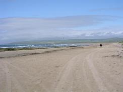
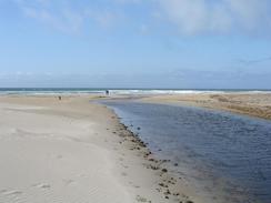
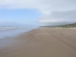
The rest of the walk was along a lovely beach, and it was the longest stretch of beach that I have walked along since the Ayrshire Coast a few weeks ago. It was intermittently sunny, and I really enjoyed the walk northwards along the firm sand. At one point I saw a seagull with a broken wing walk to and fro through the surf; it's left wing was dragging pathetically on the ground and it seemed to be looking for any food that may be washed up. When a big wave came in it tried to fly away, it's right wing flapping but the left wing just lying on the ground. Such a sight really saddened me; but there was nothing that I could do.
It feels really strange to be walking northwards once again, after turning south at Cairndow for the long walk southwards along Loch Fyne. I will be walking northwards to Fort William, where I am planning to climb Ben Nevis if the weather is good. At Fort William I will be turning to head westwards to Ardnamurchan Point and Malliag, and then the really hard yet beautiful section of the walk begins.
Directions
This walk starts off at the car park at the top of the Mull of Kintyre. Initially I headed northwestwards down he road past the first hairpin, when a path leads off across the moorland to the right for a couple of hundred yard to a memorial cairn at NR593087; I then headed back up to the car park.
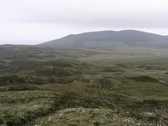
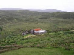
The next section of the walk heads northwards across the moorland from the car park. The route is not pathed, but navigation was easy for much of the time as I veered slightly to the right until I met a fence. This fence head northwards, and although it veers away from a northerly direction occasionally it follows the 600 easterly line fairly well. Underfoot the going is quite hard, with bracken hiding some water-filled groughs that you have to be careful not to fall into. I passed over the 369-metre Corr Bhan and then bypassed the summit of the 289-metre Sliabh a' Bhiorain, and on the descent from the latter I approached a plantation. I then veered to the right to head for the southeastern corner of the plantation, and then on to an obvious track that heads northwards and then westwards towards an old farm at Largieban.
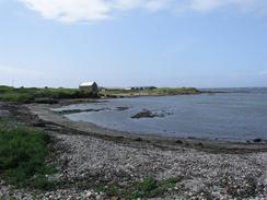
Here I was faced with a choice; I had planned to climb up to the summit of Cnoc May, but this was covered in clouds, so I decided to head northeastwards and climb over the shoulder of Cnocan Biorach, before turning to head northwards towards the corner of a plantation at grid reference NR616161. From here contour northwards along the side of Creag nan Cuilean, and then when the western side of the hill is reached turn to the right and head north-northeastwards towards a transmission mast obvious on the hillside. The going was quite hard with a few drainage channels to cross, and there were some deer fences protecting a newly planted woodland that I had to skirt before eventually making my way down to the farm track that leads to Ballygroggan Farm. Turn right along this track and after a few hundred yards turn left down a road that heads northwards before it becomes the B843 road. When this road meets the coast it turns to the right to head eastwards through the village of Machrihanish.
Pass the pub in the village and then at the start of a golf course turn to he left to join the beach. Walk northeastwards along the beach for a short distance until the mouth of Machrihanish Water is reached. I was tempted to cross this, but in the end I walked upstream a short distance to a few bridges over the water and then headed back to the beach. Continue northwards for another couple of miles until the beach ends at Westport; join the road and head north for a little under a mile to the car park at Tangy Lodge, where this walk ends.
Distances
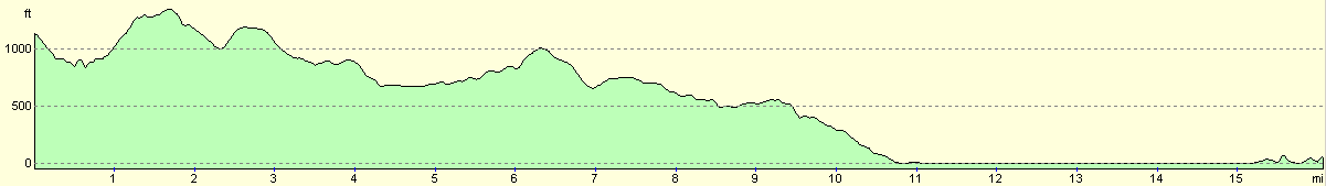
| From | To | Distance (m) | Ascent (ft) | Descent (ft) |
|---|---|---|---|---|
| Mull of Kintyre car park | Beachcomber pub, Machrihanish | 11.7 | 1572 | 2697 |
| Beachcomber pub, Machrihanish | Tangy Lodge car park | 5.1 | 259 | 207 |
This makes a total distance of 16.8 miles, with 1831 feet of ascent and 2904 feet of descent.
For more information on profiles, ascents and descents, see this page
Accommodation
We parked Mervan in the car park near Tangy Lodge, a little under a mile to the north of Westport on the A83.
Disclaimer
Please note that I take no responsibility for anything that may happen when following these directions. If you intend to follow this route, then please use the relevant maps and check the route out before you go out. As always when walking, use common sense and you should be fine.
If you find any information on any of these routes that is inaccurate, or you wish to add anything, then please email me.
All images on this site are © of the author. Any reproduction, retransmissions, or republication of all or part of any document found on this site is expressly prohibited, unless the author has explicitly granted its prior written consent to so reproduce, retransmit, or republish the material. All other rights reserved.
Although this site includes links providing convenient direct access to other Internet sites, I do not endorse, approve, certify or make warranties or representations as to the accuracy of the information on these sites.
And finally, enjoy your walking!
This walk was mentioned in the following routes:
| My walk around the coastline of Britain |
Nearby walks
| # | Title | Walk length (miles) |
|---|---|---|
| 477 | Grogport to Campbletown | 19.0 |
| 478 | Campbletown to Mull of Kintyre | 22.1 |
|
|

|