Walk #728: South Downs Way: Amberley to Hassocks
 |
 |
|
General Data
| Date Walked | 03/06/2006 |
| County | West Sussex |
| Start Location | Amberley station |
| End Location | Hassocks station |
| Start time | 08.09 |
| End time | 17.41 |
| Distance | 23.8 miles |
| Description | This was a superb day's walk following the South Downs Way, with some steep climbs but also some fantastic views to be had. |
| Pack | Today I carried my 30-litre Karrimor rucksack filled with my waterproofs, three litres of water, a book and various other odds and ends. |
| Condition | I only had a couple of twinges from ym right knee today (I was not wearing my knee strapping), and I could probably have walked further if I had needed to. The wrost problem was sunbirn - the back of my neck is slightly burnt, but the backs of my legs are very red. |
| Weather | Today was hot and sunny day with few clouds to be seen. It was quite hot, although there was a slight breeze that gave a welcome cooling when I was exposed to it. Initially the skies were hazy, but as the afternoon went on the views became more expansive as the haze lifted. |
| OS map | Landranger number 198 (Brighton & Lewes, Haywards Heath) |
 |
 |
|
 |
 |
|
Map of the walk
Maps courtesy of Google Maps. Route for indicative purposes only, and may have been plotted after the walk. Please let me have comments on what you think of this new format. For a detailed table of timings for this walk, please see the table file.
 |
 |
|
 |
 |
|
Notes
I last did any walking along the South Downs Way in late January, and I wanted to get a few more miles of it under my belt soon, as the year was progressing and I had a target of completing the National Trail this year. It had been my intention to do this last weekend over the bank holiday, which would have seen me completing the trail, but the forecast of bad weather (which did eventuate) forced me to make alternative plans - the South Downs are too much of an attractive place to visit in the rain if it can be avoided.
As I wanted to do a long distance today, well over twenty miles, and I had to drive down to the start of the walk in West Sussex, I set off at about five thirty for the long drive down the M11, M25 and M3. I had wanted to park at Hassocks, the planned end of the day's walk, and catch the train to Amberley, the start of the walk. However as the train journey was going to be well over an hour it meant that I would not be able to start until after ten, and given the weather forecast of hot weather I decided to change my plan and start at Amberley, which meant that I would be able to get some miles in before it got very hot.
It took me longer than expected to reach Amberley, and when I reached the station I was surprised to find that there is a museum there - the Amberley Working Museum, a 36-acre industrial museum situated in an old chalk pit. Ordinarily it is the sort of place I would be fascinated by, but it was not due to open for many hours and I had not even started the day's walk yet. A little stroll along a road north from the station took me to the point where I had left the South Downs Way back in January - on that occasion I had gone north for a few miles to Pullborough. Fortunately there was a good apt separated away from the road, as despite the early hour it was quite busy.
Having reached my previous point on the Way I turned around and walked back for a couple of hundred yards, before turning left to climb up a minor road, the first ascent of the day. The road climbed up quite steeply, and I started getting some fairly expansive views to the north, which was unfortunately spoilt slightly by a haze. Near the top I met a woman walking in the opposite direction, who was in raining for a woman's group walk along the South Downs Way, taking nine or ten days to complete the entire route. We chatted for a while, and noted with dismay a big pile of manure that had been dumped in a field near a memorial bench.
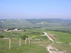
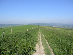
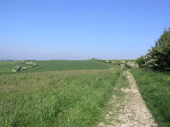
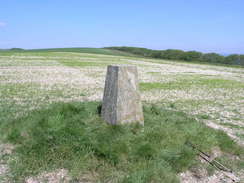
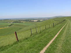
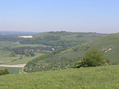
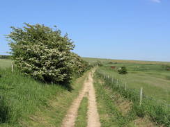
Shortly after this the Way left the road, and headed off across Amberley Mount. The walk was enjoyable and the day had not yet got too hot, and I soon found my first target for the day - the trig pillar on Rackham Hill, sitting in a chalky field. The views from here were also good, and I stopped for a few minutes to take some photographs before heading on along a track, descending to a car park before climbing once more towards Chantry Hill. There was a trig pillar here a short distance away from the track, but I decided not to visit it as it was out of sight over the crest of the hill. A horse and rider passed me, the first I can recall having seen on the Way (which is a bridleway or its entire length, except for the Beach Head loop). There were also many joggers about, and the path felt very well used, although firm and not rutted underfoot.
The bridleway continued on, staying at more or less the same level before eventually dropping down off the hills at Barnsfarm Hill and joining a road shortly before the A24 was reached. I had to cross this carefully (there is a loop a little further north that leads into Washington for riders, which is far safer). Almost immediately the way started climbing once more, passing a small car park where two young lads were getting ready to go on a bike ride, and soon I was puffing as the steepness of the ascent started to hit me. The way curved around to reach another trig pillar near Cross Dykes, and I stoppe dhere for a welcome rest for twelve minutes, sitting with my back to the pillar looking at the views. Shortly afterwards came to Chanctonbury Ring, a small Iron Age hillfort. There is a ring of beech trees around the fort, planted in 1760 by Charles Goring, although many have been replanted several times, including after the 1987 Hurricane. It was a busy place, and a cyclist was cycling up and down the banks of the ring, using it as a mini mountain-bike run, which seemed to be a good way of eroding the earthworks.
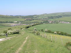
The bridleway continued on to the trig pillar on Steyning Round Hill, and on the way I started to be passed by many runners coming in the opposite direction. They were all wearing numbers, and this showed them to be taking part in a day-long relay race along the entire South Downs Way, a quite amazing feat (there is actually an annual race along the entire Way where people run the entire thing - an even more amazing feat). The runners seemed to be quite tired, which was not surprising as they just undergone a long climb uphill. The path descended to run alongside a road - a nice path ran in the field beside the road, but most of the runners chose to run along the tarmac instead.
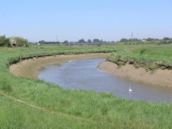
The path eventually turned to the left and started descending alongside Steyning Bowl, before reaching a farm and descending down to cross the River Adur on a bridge. Shortly after this the A283 road was reached, and in a car park there were many cars and runners either cooling down or warning up. It turned out that this was one of the relay changes, and from one of the runners I found out that the legs were anything up to eight miles in length. Everyone around seemed to be ultra-fit and, slightly embarrassed by my lack of fitness, I left them behind and started a long climb eastwards up Beeding Hill. The bridleway joined a road, and along this stretch I met the last few runners, all men. The road ended by the youth hostel at Tottington Barn, and the bridleway continued on towards some masts on Truliegh Hill. On the map there is a trig pillar bear the masts, but I could not be bothered going off the path to have a look for it.
Next came Edburton Hill, and as I was walking along I met another walker who was walking at a fast pace. We started chatting, and it turned out that he was walking from Amberley all of the way to Lewes today - he had set over an hour later than me and was going about five miles further, a goodly distance. It turns out that he was preparing for a Challenge walk later in the year, and wanted to start doing long distances so that it would not be too much of a shock to his system. As we approached Devil's Dyke we decided to nip into the pub for a drink and a rest. The place was bustling both inside and outside, and after buying him a drink I went to sit on a bench outside, whilst he had a meal. There was another walker on a bench near the door, and I sat down opposite her and we started chatting. She was relatively local and had started walking from Amberley the previous day, having camped overnight on Chanctonbury Ring. We had a pleasant chat, and I therefore spent much longer at the pub than I had planned. It was a welcome break, however, and when first the man, and then the lady left, I was left on my own for a few minutes before I too set off.
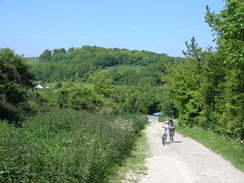
I made a little diversion to the trig pillar on Devil's Dyke, where I got some good views of some paragliders, and then rejoined the South Downs Way as it started to descend past the dyke (a large channel cut during the ice age) to the few scattered houses at Saddlescombe. I started to realise that my legs had got sunburnt as they started to itch, but as I was near the end of the day I did not stop to zip the trouser legs onto my shorts. Instead I climbed steeply up West Hill, where I passed the lady once more, and descended down a track towards the A23(T) at Pyecombe. The track joined a road that skirted the A23(T) for a few yards, with a horse riding school on the left; there was an event (a Gymkhana?) going on, and I watched the horses going around in an arena as I passed many horseboxes that were parked in the car park.
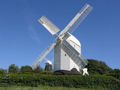
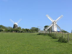
This took me on to a bridge over the A23(T), and a short distance later I came across the charming Pyecombe Church. I now had an option; I could walk north to Hassocks, which would save me some time, but instead as I was feeling fit I decided to continue on along the Way. A road led me to a golf course, and the usual warning signs were passed as the Way headed uphill along a track. As the gradient levelled off it turned sharply to the left to head northwards towards the two windmills of Jack and Jill. Fairly soon the way turned sharply to the right to regain an easterly course, but I continued on down the track past Jack (a black brick windmill) to the car park for Jill (a white wooden post mill). I walked through the car park and got some good views of Jill, including an intricate fan-wheel that used to ensure that the mil was turned into the wind.
A path headed steeply downhill from the windmills, and the views over the plains to the north were very expansive. I could not help but to look back up the slope towards the two windmills, and this delayed my reaching the road at Clayton. The path to Hassocks was well signposted, and I followed this as it crossed some playing fields at an angle, and then skirted the A273 road for a short distance. A footpath then headed on along the eastern side of the railway line, leading me directly to the station at Hassocks. I climbed some steps that led to the station and purchased a ticket, and was pleasantly surprised to find that a train was due in a few minutes. It duly arrived, and after a change at Three Bridges, I arrived at Amberley in the early evening.
The drive to Hassocks from Amberley took me much longer than expected, but I soon managed to find the campsite in nearby Keymer. I was greeted by a man who told me that the owners were not available, but I could pitch anywhere. I did so, and after putting my tent up went for a stroll to the pub in the village, the Greyhound, and had a nice meal that was washed down by a couple of pints. It was well after nine by the time that I strolled back to the campsite and, seeing lights on in the owner's house, went and paid for the night. It had been a long and tiring day, but the walk had been superb, the best that I have done for some time.
 |
 |
|
 |
Directions
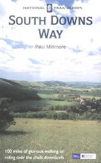
The walk is also covered in detail in the South Downs Way National Trail Guide, by Paul Millmore, ISBN 1 85410 966 9 published by Aurum Press Ltd.
The exception to this is at the start and end of the day. At the start of the day, leave Amberley station and walk down the entrance road to reach the B2139 road. Turn right along the road, heading away from the railway overbridge; there is a pavement tunning on the left-hand side of the road. The road curves to the left as it passes an entrance into the Amberley working museum, and settles on an northerly course as it passes a road junction on the right. Continue straight on for another hundred yards (the pavement disappears behind a hedge that separates it from the road) until the South Downs way is reached when a track leads off to the left.
At the end of the day, climb the hill from Pyecombe using the South Downs way as it passes a golf course. At the top of the hill the track turns sharply to the left to pass northwards past New Barn Farm; after a short distance the South Downs Way turns sharply to the right to head eastwards up another track. Instead of taking this track continue on northwards downt the track towards a black windmill; just before this is reached turn right along a footpath that heads between hedges, skirting to the right of the black windmill and soon after passing a white post windmill.
After this the path descends steeply downhill with a hedge on the left, when the hedge turns to the left sharply the footpath follows it. It then turns to the right, joining a faint track that heads down a slight slope and joining a track that ends at a road in Clayton. Cross the road and enter a recreation ground; turn half-left and cross the grass, aiming for a gap in the hedge ahead. This comes out at the A273/B2112 junction; cross the B2112 and walk along the A273 for a few yards until a bridge over a railway line is reached.
Just before the bridge is a footpath; turn right and follow this footpath for a mile and a half as it heads northwards alongside the railway line. The footpath ends at the B2116 road in Hassocks; to reach the railway station turn left to walk under the railway bridge, and immediately on the other side turn right to climb some steps that leads up to the station forecourt.
Distances
| From | To | Distance (m) | Ascent (ft) | Descent (ft) |
|---|---|---|---|---|
| Ambeley station | South Downs Way | 0.5 | 49 | 46 |
| South Downs Way | A24 | 6.1 | 856 | 574 |
| A24 | River Adur | 6.5 | 600 | 928 |
| River Adur | Devil's Dyke pub | 4.4 | 1073 | 377 |
| Devil's Dyke pub | Jack and Jill windmills | 4.3 | 646 | 735 |
| Jack and Jill windmills | Hassocks station | 2.0 | 56 | 495 |
This makes a total distance of 23.8 miles, with 3280 feet of ascent and 3155 feet of descent.
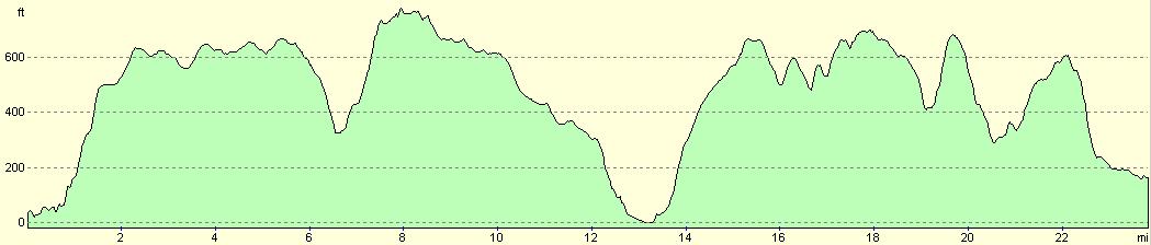
For more information on profiles, ascents and descents, see this page
Accommodation
I spent the night at the campsite at Southdown Farm in Keymer, about a mile away from Hassocks station. The site was clean and tidy with a good view of the Jack and Jill windmills on the Downs a short distance to the south. The cpasite cost me seven pounds for the night, and their address is Southdown Farm Caravan & Camping, Lodge Lane, Keymer, Hassocks, West Sussex, BN6 8LX, tel. (01273) 843278 or (07801) 477941. They have a website at http://www.southdown-farm.co.uk/. There are facilities, including a god pub and some shops, a short distance away.
Transport
There are regular train services from Hassocks back to Amberley, changing at Three Bridges on the way. See the National Rail Enquiries for more information.
Disclaimer
Please note that I take no responsibility for anything that may happen when following these directions. If you intend to follow this route, then please use the relevant maps and check the route out before you go out. As always when walking, use common sense and you should be fine.
If you find any information on any of these routes that is inaccurate, or you wish to add anything, then please email me.
All images on this site are © of the author. Any reproduction, retransmissions, or republication of all or part of any document found on this site is expressly prohibited, unless the author has explicitly granted its prior written consent to so reproduce, retransmit, or republish the material. All other rights reserved.
Although this site includes links providing convenient direct access to other Internet sites, I do not endorse, approve, certify or make warranties or representations as to the accuracy of the information on these sites.
And finally, enjoy your walking!
This walk was mentioned in the following routes:
| The South Downs Way |
Nearby walks
| # | Title | Walk length (miles) |
|---|---|---|
| 299 | Peacehaven to Worthing via Brighton | 20.5 |
| 300 | Worthing to Pagham | 18.7 |
| 596 | Wivelsfield to Newhaven | 22.7 |
|
|

|