Walk #602: Great Chesterford to Swaffham Prior
 |
 |
|
General Data
| Date Walked | 17/04/2004 |
| County | Essex, Cambridgeshire |
| Start Location | Great Chesterford station |
| End Location | Swaffham Prior |
| Start time | 06.52 |
| End time | 14.16 |
| Distance | 21.5 miles |
| Description | This was quite an enjoyable walk, taking in five trig points in Essex / Cambridgeshire on the way north. |
| Pack | Today I carried my 30-litre Karrimor HotRock rucksack, which was filled with my waterproof leggings, water bottle, trainers and a couple of spare shirts, together with the usual assortment of odds and ends. It weighed slightly more than usual as I also had a bit of extra kit, such as my Psion, battery charger, cables and a tripod strapped to the side of the rucksack. |
| Condition | I feel absolutely fine after this walk, and could easily have walked further if I had anywhere to walk to. M feet did not hurt as much as they did on the last walk, so I assume that my boots have now worn in. |
| Weather | The day started off quite foggy, and it was only around midday before the sun finally burnt the last vestiges of it off. The fog was replaced by blazing sunshine and I soon started overheating, although by later on the clouds started to gather and it cooled down appreciably. There was little, if any, wind, and there was also no sign of any rain. |
| OS map | Landranger number 154 (Cambridge & Newmarket, Saffron Walden) |
 |
 |
|
Map of the walk
Maps courtesy of Google Maps. Route for indicative purposes only, and may have been plotted after the walk. Please let me have comments on what you think of this new format. For a detailed table of timings for this walk, please see the table file.
Notes
My initial plans for this weekend was to walk from Lincoln to Market Rasen today, but I had to change my plans when Sam needed the car. I really did not want to be bothered doing a train-based walk, and so I decided to do one much closer to home. A little thought and a look on the map gave me a nice, twenty-mile stroll from Great Chesterford in Essex to the Swaffhams in Cambridgeshire, taking in five trig points on the way. To get to Great Chesterford from my home in Great Shelford I had a ten-minute train journey, and so I set off to the station as soon as I awoke, and arrived at the start of the walk well before seven in the morning.
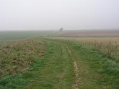
I was disappointed to find that the morning was misty; although not known as being a massively scenic area, I would still have preferred to be able to have some of the local views. For the first part of the walk I planned to follow the Icknield Way northeastwards across the Essex/Cambridgeshire border to the village of Linton. I had walked this stretch before as part of my Land's End to John O'Groats walk, and thus it held absolutely no surprise to me. Great Chesterford itself is quite a nice little village, and has some interesting houses in it. I could not get a good photograph of the church due to the mist, and so I satisfied myself by taking some photos of these houses.
A track lead uphill out of the village, route finding being very easy due to the Icknield way makers at every junction. The path skirted through Butonwood Farm, and soon afterwards I reached the site of Catley Park trig point. When I had previously walked past a couple of years ago I had not been able to find the pillar, but after squeezing through a hedge I soon managed to find it in a field adjacent to the path. The top had been damaged slightly, but I recorded the flush bracket number and started back down to the trail. This soon headed gently downhill along a narrow lane, flanked by tall hedges on either side, towering over and forming a green tunnel. It was still misty and visibility was low, but that just added to the atmospheric effect. As I walked I saw suddenly saw four or five deer in front of me, and as I got nearer they finally heard me and bolted off down the path, their white tails bouncing up and down as they did so. Walking rarely gets any better than that.
The B1052 road interrupted the rural scenes, and took me down past Linton zoo into the village of Linton. This is a very attractive village with some beautiful houses in it, and I enjoyed the walk through this time as much as I have previously. Because I had to change my plans I had come out with no food, and so I made a diversion to the Norths Bakery shop. Norths have a sandwich van that comes to my place of work and deliver far too much nice and tempting food! Strengthened by the rapid munching of a BLT baton I walked over the bridge over the River Granta before taking a road that led northwestwards towards Hildersham. A track then took me up to the old Roman Road, which I have walked along on several different occasions, before taking a track that headed up towards Gunner's Hall.
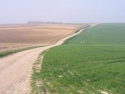
My next target was to reach the trig point on the top of the hill. I skirted past a farm shed and that headed uphill to reach the trig point. The mist was slowly lifting and the views were slightly better, so I took a few photographs before heading downhill to the north to reach a track. This led slowly down to a road, and I then climbed uphill across the hillside to the northeast, taking advantage of a track that was not marked on the map to skirt some woodland, from which the slightly scary sound of shotguns was coming. I then a steep but short climb onto the top of Fleam Dyke, and this was a real pearl of a surprise. The Dyke was very much reminiscent of the seven-mile long Devil's Dyke further to the north that I have walked on several different occasions, and although overgrown it was an impressive sight, and all the better for having been unexpected. The dykes are very much unknown quantities; they originally stretched from the flooded lowlands to the west and the forested downs to the east, covering the only effective route through the region, the Icknield Way. Originally they were though to have been pre-Roman, but archaeological investigations have shown third century Roman remains below the dyke. This has led people to believe that the dykes were built sometime between the fourth and seventh century, when the Angles and Saxons were defending East Anglia from each other and the Danes.
Yet more good tracks wound around the hillsides, leading generally in a northerly direction before ending at a road beside Wadlow Farm. A short stroll along he road took me to the farm at Lark Hall, and I then headed uphill to visit the nearby Chilly Hill trig point. Yet again I took some photos and admired the view, which was by far the best of the three trig points that I had visited so far today. A farmer waved as he passed me in a Land Rover, and so instead of crossing the field back down to the road I took a track that skirted the top edge of some woodland before descending back down to the road. The next item that I wanted to find was an Ordnance Survey bolt at Six Mile Bottom, where the A11(T) and A1304 meet. A bolt is a much more important benchmark than most trig point pillars, but it is also much smaller. Once I reached the required grid references I had a quick look around but I could not find it. I did not want to spend too long looking, so I headed away along the A1304 vowing to come back sometime to look for it again.
The Green Man pub at Six Mile Bottom did not open for another fifteen minutes, and as I did not fancy waiting around I decided to stroll on before taking a break. As I neared a windmill on Bungalow Hill to the right I left the road and headed westwards along a wide green lane over Allington Hill, passing a gallops before reaching a bridge over the A11(T). A few hundred yards further on I came to the Street Way trig point, the next one on my list to visit. This pillar was in a shocking state, slanting at an angle and with a large part of the top having been broken off leaving the column down the middle clearly visible. The flush bracket was still visible, however, and I took a note of the number before taking my rucksack off and sitting down for a rest. As I sat on the grass in the sunshine I felt wonderful, as though I had not walked any distance at all, and I soon found myself lying down as I watched the clouds pass by overhead.
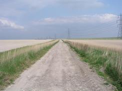
The sound of an engine woke me from my reverie fifteen minutes later, and as I looked behind me I was surprised to find a red transit van coming along the lane from behind me. A man in the passenger seat waved at me as he passed, and a few minutes later they came back and parked by some wooden power line poles slightly ahead of me. With other people about the spot did not feel quite as magical, and so I picked up my pack, dusted myself off and headed along the track. A track over a tree-lined bridge led me across the A14(T) and down past the farm at Spring Hall before ending abruptly at the A1303 road. After crossing the road another track took me on past Chalk Farm, and I soon found myself crossing a ploughed field to reach the last trig point of the day at Chalk Farm. This was in near-perfect condition although I found it hard to get the number off the flush bracket through the dense hedge! Eventually I succeeded, and headed down a track to a road.
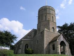
This road led me northwestwards for a mile into the little village of Swaffham Bulbeck. This was where I had arranged to meet Sam, but as I was still feeling fit I phoned her and arranged to meet her in the next village along, Swaffham Prior. A quick jaunt along the B1102 (which fortunately had a pavement alongside the busy road) took me north towards the village. I left the road and took a local road that passed Swaffham Prior House before reaching the centre of the village, where I came across not one, but two churches, nearly side-by-side and bother featuring unusual towers - square at the base, octagonal on the first floor and near-circular on the top. I was curious about why there might be two churches close together, and when I reached the village pun a few yards on I went in and waited for Sam. I had run out of water an hour before, and so I sunk down the first pint very quickly, and then enquired about the churches. Apparently the first church was derelict when a new church was built in the 1700's; then, a hundred years later, two sisters had a falling out and one of them rebuilt the original church. Hence the village has been left with two adjacent grand churches. I mused over the way an argument could lead to two beautiful pieces of architecture, and when Sam came I slowly sank down an orange and lemonade before leaving for the short drive home. All in all this had been a good day's walk, even though it was hardly classic walking terrain.
Directions
From Great Chesterford Station turn left up the station approach. When you reach the B1383 Newmarket Road turn right and follow it to cross the River Granta via a bridge. Take the first road to the right (Church Street) that you come to and head past the church. Continue along this road through Great Chesterford past the Crown and Thistle and the Plough pubs until you reach the B184 road. For this entire section you can follow signs for the Icknield Way, which this route follows until the village of Linton is reached. Turn right along the B184 and then after a hundred yards turn left up a small track leading uphill alongside a hedge. The track soon becomes a footpath that heads south-northeast across fields towards Burntwood Farm. Continue past Burntwood Farm up to a trig point near some power cables. From here on follow the Icknield Way down a hedge-lined green lane until the path emerges out onto the B1052 road. Turn left and head downhill along the B1052, passing Linton Zoo on the way, before the road ends at a T-junction with the A1107 Cambridge to Haverhill road near the village of Linton.
At the A1107 turn left to head westwards for a few yards, before turning to the right and crossing the road to gain access to the B1052 High Street once again. Follow the road as it heads downhill through the pretty little village, curving to the right before reaching a bridge over the River Granta. Immediately beyond the bridge turn to the left and follow Hillway for a few yards before tuning left along Symmonds Lane, which heads northwestwards before eventually curving to the right and ending at a T-junction with Back Lane. At the junction turn left and follow Back Lane as it heads northwestwards for a couple of kilometres until a crossroads is reached to the north of Hildersham. At the crossroads turn to the right and follow a road uphill to the northeast for a couple of hundred yards before turning off to the left along a green track that runs northwards for a little over a kilometre before meeting a junction with the Roman Road. Cross the Roman Road, and once on the other side head uphill to the north to reach some farm buildings at Gunner's Hall.
Just before the buildings are reached turn right along a track for a hundred yards, and then turn to the left to head uphill across a field to a trig point. Pass the trig point and continue northwards down a slight hill until a track is reached; at the track turn right and follow it as it curves to the left and heads northeastwards before ending at a road. Here I turned right for a few yards to reach a field boundary, and then turned to the left to head uphill along a track that is not on the Ordnance Survey map. The track heads northeastwards, and then skirts the edge of a small patch of woodland before descending down to meet a steep sided bank. This bank is part of Fleam Dyke; climb up it and once at the top turn right to head southeastwards along the footpath that runs along the top of the dyke. After a couple of hundred yards when some woodland appears on the left, descend from the bank and turn to the left to head northeastwards along the edge of the woodland, which turns to head eastwards for a short distance before ending at a track.
Once on the track follow it as it heads northeastwards; after a few hundred yards it turns to the right to head eastwards. Again after a few hundred yards turn left along another track that heads northwards before curving to head on a more northwesterly direction. When the track meets a crossroads with another track turn to the right and head downhill to the northeast, before the track meets a road by Wadlow Farm. Continue straight on along the road and follow it, as it almost immediately turns to the left to head in a northerly direction towards the farm at Lark Hall. Once at the farm turn right and head uphill to the northeast, aiming for a gap in the trees where the Chilly Hill trig point can be found. Instead of heading back down the field to the road you can follow a track that skirts the edge of some woodland northwestwards, and when the woodland ends turn left along another track that leads back down to a road. Once at the road turn right and follow it northwestwards; it nears the A11(T) before turning to the right and ending at the A1304 road by the A1304 / A11(T) junction.
Head northeastwards along the A1304 for a couple of kilometres, it crosses the Cambridge to Newmarket railway line art Six Mile Bottom before heading up a slight gradient towards the top of Bungalow Hill. Just before a windmill is reached on the right turn left down a broad green lane that heads west-northwestwards over Allington Hill before crossing the A11(T) on a high bridge. A few hundred yards further on a trig point is reached, lying half-demolished in the hedge on the left, and a little further on still another track leads off to the right. Take this track and follow it as it heads northwards for a couple of hundred yards before curving to the left and reaching a bridge over the A14(T). The track then heads past the farm at Spring Hill before ending at the A1303 road. Turn right down the road for a few yards before taking another track that leads off to the left, heading up a light hill to the north. When the track curves to the left to go into Chalk Farm continue straight on with a hedge on the left; when the hedge ends turn left and walk westwards to another track.
Join the track and turn right to head up a light hill to the northeast for a couple of hundred yards, before turning to the left to head across a field to the north-northwest to reach a trig point in a hedge. Once at the trig point turn right and follow a track northwards down a hill until it meets Swaffham Heath Road. Once at the road turn to the left and follow it west-northwestwards until it ends at a junction with Heath Lane on the outskirts of Swaffham Bulbeck. Turn right and follow Heath Road as it heads northwards for a short distance before curving to the left and ending at the B1102 road. Turn right and follow the B1102 northeastwards past Commercial End towards Swaffham Prior House. Immediately after the entrance to the house turn left down a slip road off the B1102 that becomes he High Street in Swaffham Prior. Follow this road as it heads northeastwards through the village, passing to the left of the twin churches, before reaching the Red Lion pub on the right, where this walk ends.
Distances
| From | To | Distance (m) | Ascent (ft) | Descent (ft) |
|---|---|---|---|---|
| Great Chesterford station | Linton | 5.1 | 315 | 295 |
| Linton | Six Mile Bottom | 10.1 | 692 | 725 |
| Six Mile Bottom | Swaffham Prior | 6.2 | 161 | 217 |
This makes a total distance of 21.5 miles, with 1168 feet of ascent and 1237 feet of descent.
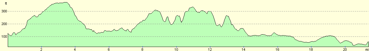
For more information on profiles, ascents and descents, see this page
Transport
My girlfriend picked me up from Swaffham Prior at the end of the walk, but there are some bus services south from the village into Cambridge, where trains can be caught to Great Chesterford.
Disclaimer
Please note that I take no responsibility for anything that may happen when following these directions. If you intend to follow this route, then please use the relevant maps and check the route out before you go out. As always when walking, use common sense and you should be fine.
If you find any information on any of these routes that is inaccurate, or you wish to add anything, then please email me.
All images on this site are © of the author. Any reproduction, retransmissions, or republication of all or part of any document found on this site is expressly prohibited, unless the author has explicitly granted its prior written consent to so reproduce, retransmit, or republish the material. All other rights reserved.
Although this site includes links providing convenient direct access to other Internet sites, I do not endorse, approve, certify or make warranties or representations as to the accuracy of the information on these sites.
And finally, enjoy your walking!
Nearby walks
| # | Title | Walk length (miles) |
|---|---|---|
| 2 | Waterbeach to Newmarket Road, Cambridge | 5.4 |
| 5 | A short walk around Waterbeach to Car Dyke | 3.0 |
| 6 | Waterbeach to Newmarket Road, Cambridge | 5.4 |
|
|

|