Walk #612: A circular walk from Buckingham to Silverstone
 |
 |
|
General Data
| Date Walked | 22/06/2004 |
| County | Buckinghamshire, Northamptonshire |
| Start Location | Buckingham |
| End Location | Buckingham |
| Start time | 08.00 |
| End time | 15.02 |
| Distance | 18.8 miles |
| Description | This was a pleasant stroll, with a surprising amount of interesting things to see on the route. |
| Pack | Today I carried my 30-litre Karrimor HotRock rucksack, which was filled with my waterproof leggings, water bottle, trainers and a couple of spare shirts, together with the usual assortment of odds and ends. It weighed slightly more than usual as I also carried a couple of litres of extra water. |
| Condition | I feel absolutely fine after this walk, indeed better than I have after the last two or three walks, and I could easily have walked further after a little rest. I have no blisters, and the only ache I have is a slight pain in the underside of my left foot. |
| Weather | The day started off bright and sunny without many clouds in the sky; as the day went on, and especially in the afternoon, the clouds started gathering and the wind strengthened. Fortunately this never threatened any rain, for which I was thankful as some heavy downfalls were forecast for later in the day. |
| OS map | Landranger number 152 (Northampton & Milton Keynes) |
 |
 |
|
 |
 |
|
Map of the walk
Maps courtesy of Google Maps. Route for indicative purposes only, and may have been plotted after the walk. Please let me have comments on what you think of this new format. For a detailed table of timings for this walk, please see the table file.
 |
 |
|
Notes
When I booked today off work I knew perfectly well which walk I wanted to do - a twenty mile stroll in Lincolnshire, taking in the highest point in that county on the way. I started revising the plans last night, when a hectic day at work had left me not wanting to even contemplate the two and a half hour journey each way to Market Rasen. A quick look at my maps led me to decide on doing a circular walk from Silverstone - either to Buckingham or Brackley. A little more thought led me to settle on the latter, which would allow me to connect the walk up with Banbury and the Oxford Canal at a later date.
Like all the best plans, this one failed the first moment it met reality. The drive to Silverstone went well until I reached Milton Keynes, when I missed the correct turning and I ended up driving along the road towards Buckingham and Brackley. This made me decide to do the walk in reverse, but slow traffic on the road to Buckingham persuaded me to do a walk from there instead; I simply could not face the extra few miles to Brackley. I therefore drove into the centre of Buckingham, and was delighted to find a large, nearly empty free car park in which I could park.
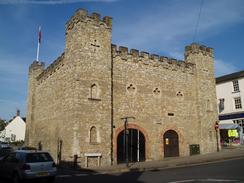
After kitting up I set off on the walk, only to return to my car when I noticed that certain sections of the car park were limited to just two hours wait. After making sure that I was in a long-stay section, I walked through a little shopping plaza and out onto the street. It was here that I was faced with my first problem; I was thoroughly disoriented and I was quite unsure about which direction to walk in. Fortunately being disoriented in Buckingham is no great hardship, and I strolled around looking at some of the delightful buildings, particularly the Old Gaol, which stands very prominently between two roads. It was the first time that I have been to the town, and it is one that I would not mind visiting again for a better look around.
Eventually I found the right road out of the town, and I started following this before diverting off down Stowe Avenue. Near the start of this long, straight road were the initial signs that I was in for some architectural delights; there are two small cottages (called the Buckingham Cottages, and probably built in 1805) on either side of the road that glowed golden yellow in the morning sun. The road was surprisingly busy with traffic, and so I was quite glad that there was a paved footpath on the right-hand side, separated from the road by a hedge, that allowed me to have a much safer journey. Nonetheless I was quite glad when the main road dived off to the left, and I could continue straight on along the private road that led up a slight hill towards the Corinthian Arch.
I did not know much about the grounds of Stowe School, but having a building marked on a map as a Corinthian Arch is always a promising sign. As I approached it, however, I was slightly disappointed to see that it, and the adjacent two columns, were totally enmeshed in scaffolding and cladding whilst repair work was performed. This was a shame, but I put it to one side as I followed the Ouse Way as it headed off to the left and followed a track through the grounds of Stowe. This was a highly enjoyable stretch as the grounds are all magnificently landscaped, and in the distance I could see glimpses of enticing architectural gems; a half-hidden temple, or a stone obelisk in the skyline, all in the same glorious stone.
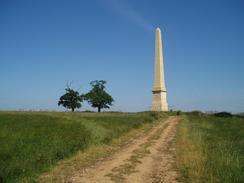
I kept on the track as it headed northeastwards, passing Oxford Water and heading past the front of Stowe School and House. Again I was to be disappointed by the house; the top of it was wrapped in the same scaffolding and cladding as the Corinthian Arch had been. This did not disappoint me too much, however, as I had my eyes set on the next target; Wolfe's Monument, an obelisk on the skyline that I could see was happily unencumbered by scaffolding. I did not now quite how I was going to get to this as there was no footpath to it marked on the map, but the area around Stowe is managed by the National Trust, and I soon reached a track that led up to the obelisk, and this was marked as being a footpath. This was good enough for me, and so I vaulted over a locked gate and headed off up the hill.
The monument looked even better from close-up than it had from a distance the stone really seemed to glow in the sun. It is over 100 feet high, and is dedicated to General James Wolfe, who was in charge of a famous victory over the French in 1759. The Obelisk was erected in 1754, and dedicated to the memory of the General five years later. I spent a few minutes studying the stone, the inscription and the nearby trig point, and then set off northwards across fields, aiming for the footpath that runs northwards through Stowe Woods. It was hard to stop myself glancing backwards every so often to take a look at the ever-reducing size of the Obelisk on the skyline, and this especially became the case when I reached the footpath through Stowe Woods; the path runs along a green track (which was once the Ridings for the Hall) that aligns perfectly with the Obelisk, which was yet another sign that I was in a patch of countryside that had been very heavily landscaped by man.
The path eventually diverted off the Ridings and headed westwards along a gap in Point Copse, and then reached a set of concrete tracks. These are part of the old Silverstone airfield, and in the distance I could see grandstands of the grand Prix circuit. The path soon joined the road, and I followed this northwards. A couple of years ago massive works were done to upgrade access to the Silverstone racing circuit, and there is now a dual carriageway running right along the western side of the circuit, and this was not marked on my map. It was nice to see that a place so synonymous with cars and speed had thought of pedestrians, as there was a wide pavement right beside the road, although the road itself was very quiet on this non-racing day. Through the fence I could see that the circuit was very busy with works going on, the British Grand prix was due to be held in a few weeks, and so I guessed that they were still preparing for that race.
I soon crossed over the new A43(T) Silverstone bypass, and headed through the village to reach the centre, where I had finished another walk from Northampton a couple of years ago. I nipped into the post office and bought myself a few snacks, including an ice cream that I wolfed ravenously down. The forecast had been for heavy rain in the afternoon and so I had not taken my usual extra water bottle with me; the rain had not materialised, and so I also used the opportunity to buya bottle of water to ensure that I would not run low. I decided to leave the village eastwards along the road towards Whittlebury, passing what is marked on the map as being a windmill. Sadly all that remained of this was a brick stump, the top half of the windmill having been removed. I have always thought of windmills in this situation as being quite sad-looking, almost as if they have been neutered.
Whilst the western half of the walk seemed obvious when I was planning this walk, I had not paid much attention to the eastern side. Rather than follow the A413 southwards from Whittlebury, I decided to follow a bridleway that is marked on the map, heading in a rough southeasterly direction. This was a very pleasant stretch of walk, with nice rolling hills. When the path crossed fields weed killer had been applied, which gave an obvious route across the fields and made the walk far easier than it would otherwise have been. Just before the bridleway reached Old Tun Copse, I joined a footpath that headed southwards, crossing a road and then joining a track that took me down to near the little village of Lillingstone Lovell. Instead of following the road to Buckingham from here, I decide to follow a footpath across fields to the village of Leckhampstead; this was a bit harder as when I had passed Hill Farm the route became less obvious, and I had to rely on my GPS to navigate in roughly the right direction.
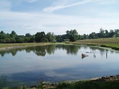
I found Leckhampstead to be an absolutely delightful village, with thatched cottages and an attractive church. It was still quite early in the afternoon and I had plenty of time, so I sat down on a bench opposite the gateway into the churchyard for a few minutes whilst I recharged my batteries and admired the view. I did not want to stop for too long, however, and I soon found myself standing off and walking along the footpath that headed uphill past the church. A short stretch of road and another short footpath took me onto a road, and I started walking along this southwestward back towards Buckingham. It was a fairly boring walk, the only high point being Foxcote Reservoir, which I did not get very good views over from the road. I was quite glad when I reached the little village of Maids Moreton, and when I saw that the church door was open I could not resist going in for a quick look around.
Being inside the church was quite relaxing, and I sat down for a few minutes to pray. The silence was marvellous, and it was with regret that I stood up and started walking once again. A bridleway took me south from near the church towards the A422 road, beside which there was a field that was full of gloriously red poppies. I was tempted to extend the walk a couple of miles by following the A413 road southwards to the river Great use, but I decided against it and instead walked westwards along the A422 back into the centre of Buckingham. On the way I found a little rag doll on the pavement; with no children insight, I moved it off to the side slightly and sat it up against the base of the lamppost; hopefully the child who dropped it will find it on the way to school in the morning. When I finally reached the car I was surprised to see how busy the car park was; it had been virtually empty when I set off this morning, but by now there was virtually no free spaces. I was quite relieved to have finished the walk and was not looking forward to the drive back to Cambridge, but I had found the walk to be much, much more enjoyable than I had been expecting it to be.
Directions
This walk starts off at the long-stay car park in the centre of Buckingham. Leave the car park and follow the pedestrianised Cornwall Place through a little shopping centre to reach the High Street. Once there, turn left and walk southwestwards towards the prominent stone-built Old Gaol building, which is now a museum. At the Old Gaol turn right and then left, to head southwestwards along Market Hill with some shops on the right, and then continue straight on to reach the A422 West Street. Turn right and start following this road as it heads westwards, passing School Lane on the right, and then turn right when Stowe Avenue is reached on the right. Stowe Avenue climbs up a slight hill, and once it passes two small attractive stone cottages on either side of the road a pavement starts on the right, and this can be followed as it heads northwestwards towards Chackmore.
When the pavement ends at a road that leads to Chackmore continue straight on to cross another road a few yards further on. At this junction continue straight on uphill along a road that leads to the Corinthian Arch, which can be seen prominently at the top of the hill straight ahead. Walk up towards the archway, and just before it is reached turn to the left and take a path that heads through some bushes to meet a surfaced track. This track heads westwards through Stowe Park, passing to the south of a little lake before curving to head northwestwards on the approach to Oxford Water. At a road junction continue straight on along a road that heads northeastwards for a little over a mile, straight past the frontage of Stowe School. Continue on for a few hundred yards until a gate is reached; here a track leads off to the left, heading up the hill towards the prominent landmark of the Wolfe Memorial, a massive obelisk.
Walk up to the Obelisk, and once there continue onwards in an exact northerly direction, crossing a fence and descending down to a little stream, before continuing uphill and crossing another fence to reach Stowe Woods. A narrow grassy track runs up the middle of the woods, and after about a kilometre turn left along a footpath that heads through a little gap in the trees. The path continues westwards for a short distance, nearing but not joining a track, before turning to the right and heading northwards beside a hedge. When another hedge is reached, the footpath turns to the left before ending at a road opposite Wetley's Wood. Once at the road, turn right and follow it as it heads northwards; fairly soon it becomes dual carriageway as it passes the western edge of the Silverstone motor racing circuit. This road continues northwards for a couple of miles, and crosses the new A43(T) on a bridge before reaching the old A43 Brackley Road on the outskirts of the village of Silverstone.
Once at the Brackley Road turn right and follow it northeastwards for a few hundred yards, and then turn to the left to follow High Street as it heads northwards into the centre of the village. Continue along this road as it passes the post office, and when it finally reaches the church and war memorial turn right along Whittlebury Road. Continue along this, and when it reaches the old A43 road cross it and continue on eastwards, passing the stump of an old windmill and heading onwards for a couple of kilometres. Just before the church in Whittlebury is reached turn left along a footpath that heads eastwards for a short distance, before ending at the A413 road. Cross the A413, and once on the other side head straight on along a bridleway that follows a track eastwards. The track ends after a few hundred yards, and the bridleway continues on in a rough southeasterly direction across fields, with an area of woodland called Buckingham Thick Copse close by to the south.
When a gap is reached in the woodland, between Buckingham Thick Copse and Old Tun Copse, turn right through a gate and follow a footpath that heads due south, with an area of woodland immediately to the right. A little under a kilometre later a road is reached; cross this road and once on the other side continue on southwards along the footpath. This meets a stream at the Northamptonshire / Buckinghamshire border; at the stream turn left and follow the footpath as it skirts the northern bank of the stream southeastwards until it meets the end of a track near some farm buildings. Join this track, and follow it as it heads southwards for a little over a mile, as it becomes surfaced and ends at a crossroads immediately to the east of the village of Lillingstone Lovell. At the crossroads continue on southwards along a road, and after a couple of hundred yards turn left along a footpath that heads southeastwards for about half a kilometre across fields towards Hill Farm.
The footpath crosses a track and then continues straight on to the southeast, slowly curving to take a slightly more southerly course as it crosses fields before ending at a road near to the access driveway for Lodge Farm. Once at the road turn right and follow it southwards for a couple of hundred yards, before it curves to the left towards Leckhampstead Church. Immediately past the church turn right, heading along a footpath between the church and a thatched cottage. This footpath heads for a short distance steeply uphill before ending at a road, at which you turn to the right along the road. Pass a house on the right, and then as the road curves to the left take a short footpath that heads off to the right, heading across a field before ending at another road. Turn right and follow this road as it heads southwestwards for a couple of miles into the village of Maids Moreton, which is now virtually a suburb of Buckingham.
Follow the road as it heads past the church in Maids Moreton, and when it curves sharply to the right turn to the left to follow a bridleway that heads off to the left, initially along a track. At some playing fields the track ends, but the bridleway continues on southwards for a few hundred yards before ending at the A422 road. Once at the A422 turn right and walk for a few yards to the roundabout with the A413 road; where continue straight on to head westwards along the A422 towards the centre of Buckingham. Less than a mile further on the centre of the town is reached, and the car park in which this walk started is on the left.
Distances
| From | To | Distance (m) | Ascent (ft) | Descent (ft) |
|---|---|---|---|---|
| Buckingham | Silverstone | 8.1 | 541 | 413 |
| Silverstone | Buckingham | 10.7 | 604 | 732 |
This makes a total distance of 18.8 miles, with 1145 feet of ascent and 1145 feet of descent.
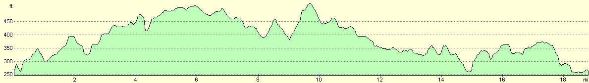
For more information on profiles, ascents and descents, see this page
Disclaimer
Please note that I take no responsibility for anything that may happen when following these directions. If you intend to follow this route, then please use the relevant maps and check the route out before you go out. As always when walking, use common sense and you should be fine.
If you find any information on any of these routes that is inaccurate, or you wish to add anything, then please email me.
All images on this site are © of the author. Any reproduction, retransmissions, or republication of all or part of any document found on this site is expressly prohibited, unless the author has explicitly granted its prior written consent to so reproduce, retransmit, or republish the material. All other rights reserved.
Although this site includes links providing convenient direct access to other Internet sites, I do not endorse, approve, certify or make warranties or representations as to the accuracy of the information on these sites.
And finally, enjoy your walking!
Nearby walks
| # | Title | Walk length (miles) |
|---|---|---|
| 146 | Bletchley to Wolverton | 11.9 |
| 157 | Wolverton to Bugbrooke | 16.6 |
| 216 | Northampton to Silverstone via Towcester | 14.5 |
|
|

|