Walk #613: Derby to Matlock
 |
 |
|
General Data
| Date Walked | 26/06/2004 |
| County | Derbyshire |
| Start Location | Derby railway station |
| End Location | Matlock Station |
| Start time | 07.21 |
| End time | 15.56 |
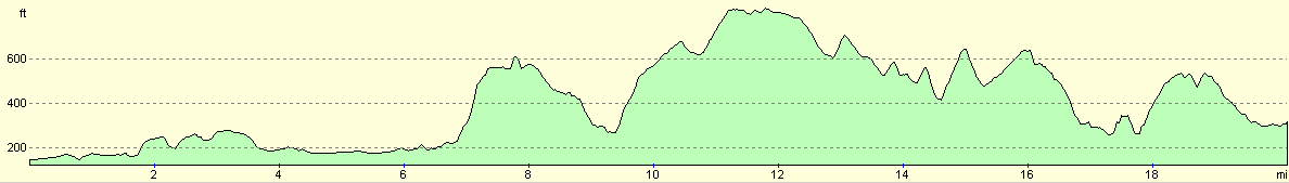
| Distance | 20.2 miles |
| Description | This was a long and surprisingly nice linear walk, heading from Derby to the borders of the Peak District at Matlock. |
| Pack | Today I carried my 30-litre Karrimor HotRock rucksack, which was filled with my waterproof leggings, water bottle, trainers and a couple of spare shirts, together with the usual assortment of odds and ends. It weighed slightly more than usual as I also carried a couple of litres of extra water. |
| Condition | I felt very good after this walk, and after a little rest could easily have walked further if I had wanted. I have no blisters, and no major aches or strains in my body. |
| Weather | For the first three hours the weather was dry, but this pleasant situation soon stopped and it started to drizzle. The drizzle never got hard, and I got wetter from walking through wet long grass than I did from the rain. After my belated break the rain stopped, but there was still not much sign of any sun. |
| OS map | Landranger number 128 (Derby & Burton upon Trent), Landranger number 119 (Buxton & Matlock, Bakewell & Dove Dale) and Outdoor Leisure number 24 (The Peak District - White Peak Area) |
 |
 |
|
 |
 |
|
Map of the walk
Maps courtesy of Google Maps. Route for indicative purposes only, and may have been plotted after the walk. Please let me have comments on what you think of this new format. For a detailed table of timings for this walk, please see the table file.
Notes
For some time I have wanted to do the twenty-mile walk northwards from Derby to Matlock, connecting up a couple of walks that I have done previously. I was not expecting the walk to be particularly scenic (especially the southern sections as far as Belper), so it was not very high on my list of priorities. This weekend I found myself at my parents in Derbyshire, and so I decided that instead of going up into the Peak District to do a walk (as I normally do if I find myself in Derbyshire) I would do this walk. I also decided that I would do the walk from south to north, as this is the direction that I did my sectional Land's End to John O'Groats walk in, and this is a slight short cut from that walk.
I arrived at the railway station in Derby at about seven, and decided to park in the car park by the station. This was my first mistake; when you drive into the car park you collect a ticket, and you cannot leave until you have paid. This is all fair enough, but when I gt out of the car I found that to park for a day - or even five minutes - cost seven pounds! If I had known this then I would not have gone into that car park and parked elsewhere in Derby. This annoyed me, and so to relax myself a little I went into the station for a quick look around and to pick up a timetable for the Matlock branch.
This was all soon done, and I found myself walking along through the streets of Derby, which were quiet at this time of day. My dad used to own a business near the station, and I was therefore walking along streets that I knew exceptionally well. I soon found myself walking through the Eagle Centre, the main shopping centre in Derby, which was unsurprisingly nearly deserted at this time of the morning. I headed northwards towards the Guildhall and a lovely little fountain that was built a few years ago to the Cathedral; this is hardly worth the name, and is really only a rebranded town church. Outside the church I chatted to a couple for a few minutes about the walk, before heading onwards towards the inner ring road.
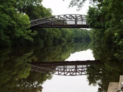
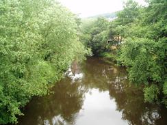
Despite having spent many days in Derby, I really did not know the northern side of the town that well, aside from the A6 corridor. I passed a Catholic church and then headed on into the Darley Abbey area of Derby, which turned out to be a pleasant surprise. For the first time in the day I saw the River Derwent near the old bridge that carries the old LNWR railway line over the river; the line is long disused, but the bridge now carries a footpath and cycle path, and allowed me to get some photos along the river. Near the bridge there is the Derby Rowing club, and as I stood on the wooden staging to take a photo downstream I was amused to read a plaque that stated that on a certain date, the president of the club had failed to walk on water!
Amused, I continued on northwards along a good path that led past the grounds of Darley Abbey. I was tempted to walk through the parkland near the river, but I was unsure about whether or not I could get out at the other end, so I decided that it would be safest to follow the path that ran alongside the boundary wall. The Abbey itself was originally an Augustinian Priory founded in around 1146, but the site was nearly obliterated during the Dissolution of the Monasteries in 1538. The only remaining part of the Abbey is the Abbey Pub, which I did not walk past, but is worth a quick diversion to if you can.
Once the Park ended I joined a road, that went uphill past Darley Abbey Church, a nice example built between 1818 and 1819, and then headed northwards towards the A6 road. A handy newsagents, bustling with teenagers struggling under heavy shoulder-slung bags of Saturday newspapers, allowed me to get a few provisions in ready for the rest of the day's walk. I soon found myself at the A6, and a few yards further on the large roundabout between the A38 and the A6. A Dutch lorry driver was lost, so after helping him find the correct route on his map, I set off up the A6 once more. As soon as the built-up area ended I dived off to the right, following a footpath that led northwards to Duffield. The first few hundred yards of the path were easy to follow, but progress soon became harder as I came across a veritable jungle of vegetation that had overgrown the path. Fairly soon I found myself having to avoid nettles and brambles that extended to above waist height, and I was quite glad when the path left the field boundary and instead cut across a field, dived under the railway line, and joined the western bank of the River Derwent.
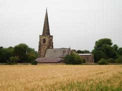
The rest of the walk into Duffield was highly pleasant, along an easy to follow path, and with St Alkmund's Parish Church clearly visible ahead. The church looked spectacular when viewed over a field of corn, and I was sad when I finally reached the road and head to leave the views behind. I then followed the road and another footpath to join the A6, which I followed through the village. I have driven through Duffield along the A6 on many occasions, but on this, my first time walking through it, I was surprised to find that Duffield had a castle. Of the castle only the mound remains of this, in National Trust care, and it must have been an impressive structure. The walls of the Keep were 15 feet thick (second only in thickness to those of the Tower of London), and was the home of the Ferrars family. One of the reasons that so little trace of the castle now remains is that it only lasted for two hundred years before being destroyed by Henry III in 1266. I did not really want to climb up to have a look around, and instead I headed off along the A6 for a short distance, before joining the Midshires Way, which I would be following for well over ten miles.
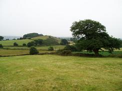
The path initially took me along a track past a golf course, before climbing fairly steeply uphill towards Courthouse Farm. There were some nice views from this climb; the first expansive ones of the day, and I soaked these in as I chatted to a couple of golfers enjoying an early morning round. A while later I decided to visit the trig point marked on the map, but as soon as I left the track, which by this time was overhung by trees, I realised that a light drizzle was falling. I soon found myself at the pillar, which was half hidden in the vegetation, and looked as though it had been moved sometime, as it was half out of the ground amongst some other rubble and standing at an angle. I took some photos and recorded the flush bracket number, before heading off back down the small hill to the track. Once I was back under the trees I was protected from the rain to a certain extent, but as soon as I reached the end of the track at Farnah Green I knew I would be exposed some more, and so I stopped to put my coat on.
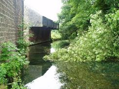
I found that the Midshires Way was quite an easy trail to follow, and it was quite well waymarked. This allowed me to put my brain more or less into neutral as I followed it to the A517, and then northwards along Long Wall Lane. The were some quite pretty views from the lane as it headed uphill, and once it ended at a road a far more boring stretch of path ensued. Things did not get much better until I reached the woodland to the north of Netherpark Farm, and although I got slightly lost in the woodland (I followed the wrong path for fifty or so yards), I enjoyed the stroll, if only because it got me out of the drizzle for a short period. The Way then passed Alderwasley School, with a well-sited war memorial right beside the path, and then headed northwestwards across fields to Watergate Farm and the Whatstandwell to Wirksworth Road. After this the walk became slightly more interesting as it followed Intake Lane northwestwards, before eventually descending underneath an incline on the High Peak Trail (formerly the course of the Cromford and High peak railway line). This bridge was more than a little interesting, and I studied the area around it for a few minutes before descending downhill to meet the A6(T) in Cromford. The bridge also marked the point where I left the Midshires Way, and I was now on unwaymarked paths.
The most obvious route from Cromford to Matlock would be to follow the A6 northwards through Matlock Bath, but I had a planned diversion off route. The next day was going to be my grandfather's 96th birthday, and he and my grandma were staying in Willersley Castle Hotel, so I had arranged to go and visit them. On the way to the hotel I descended past Arkwright's Mill, now a World Heritage Site, and Cromford Wharf, the end of the Cromford Canal, before reaching the canal. The hotel itself was a fantastic building; it was built by Richard Arkwright as a home, and has commanding views, both over the mills and the surrounding craggy hillsides. Unfortunately it burnt down during construction, and Arkwright died before it was rebuilt. I had a lovely hour with my grandparents, and uplifted by having seen them I left the grandeur of the hotel (feeling rather out of place in my boots and dishevelled clothing) and headed off back down the hill.
Walking along the A6 really did not appeal to me, so instead I chose to follow the road that heads northwards uphill to Starkholmes, foregoing the brash commercialism of Matlock Bath for a much grander walk along the road. I knew from experience that there were much better paths nearby, but nearing the end of a long day - and with a specific train in mind - I decided to stick to the road. I could see the Matlock cable cars going up to the Heights of Abraham on the other side of the valley, and as I descended down into Matlock I realised the exact moment that I reached 10,000 miles walked since the beginning of 1999. This caused me to pause for a moment and remember the walks, views, people, pain and joy that I had experienced during the last five and a half years. I reached the 10,000-mile mark right outside a pub and I was sorely tempted to go in for a drink, but I decided against it and instead strode down the road that I knew so well into Matlock itself. I soon found myself at the railway station, having missed the train that I had intended to take by a few minutes. This did not bother me, and I chatted to the main in the station shop for half an hour whilst I waited for the next train.
When the train finally came I jumped on and sat down, ready to enjoy the ride down the Matlock branch. I had not travelled on the branch line for many years, and I stared out of the window, looking for points of interest such at the 'windows' in High Tor Tunnel (actually short stretches where the tunnel gets so near to the cliff face that the side of the tunnel is actually open), Cromford Station, and the sad remnants of the once-grand triangular station at Ambergate. The ticket machine on the train was out of order, and so the guard came on the intercom telling us that he could not sell us tickets, and this meant that I got the trip for free. This slightly offset the seven pounds that I had paid to park at Derby, and proved to be an agreeable end to what had been a surprisingly superb day's walk. It is nice to think that the high spot of the day for me was not the walk itself, but walking into a hotel to see my grandparents; I do not get to see them very often, and to visit them in such a way was rather special for me.
Directions
This walk starts off at Derby railway station. Leave the station and walk through the forecourt, before taking a road that heads past the old railway institute, which is now a bar. The path from the railway station towards the centre of the town is well marked, following Liversage Walk westwards. This path soon enters the Eagle Centre, Derby's main shopping centre, and walk straight through, passing a Sainsbury's on the right. When you leave the Eagle Centre the pedestrianised Albion Street is reached; walk down this until it ends at Victoria Street opposite a covered market building. Turn left along Victoria Street for a few yards, before turning right to head up the pedestrianised Corn Market. At the top of the hill near the Assembly Rooms this becomes Iron Gate, and this can be followed northwards towards the slip roads leading off the A601 St Alkmund's Way. Do not follow the road as it curves to the left, but turn right to walk eastwards for a short distance to a pedestrian bridge that leads over the A601 towards an imposing church. Once across the bridge, head straight on along Darley Lane, which soon becomes North Parade and finally Darley Green before it ends.
When the road ends, continue straight on northwards along a surfaced path that passes the grounds of Darley Abbey before meeting Abbey Lane. Continue northwards along this lane, which becomes Church Lane as it passes Darley Abbey Church and eventually ends at the dial-carriageway A6 Duffield Road. Once this road is reached, turn right and follow it for a hundred yards to the roundabout with the A38(T) road, which heads under the roundabout. Cross the roundabout and then continue straight on northwards along the A6(T). After about a kilometre the built-up area ends, and when the road curves slightly to the left a footpath leads off to the right. Initially the path is nicely wide, but it soon squeezes northwards along the edge of a field, and was very overgrown when I walked along it. Eventually the path diverts to the right to cross a field, aiming for a small bridge under the Derby to Sheffield railway line. It is then easy to follow as it heads towards the River Derwent, and skirts this northward towards Duffield Church. The path goes through the churchyard before reaching Makeney Road beside a bridge over the river.
Once at the road turn left and cross a bridge over the railway line; as soon as you have crossed it, turn to the right and descend some steps down into a field. A footpath then heads northwestwards for a couple of hundred yards, before reaching the A6(T) once more in Duffield. Turn right and follow the A6(T) northwards through the town, passing the station car park on the right and the old site of the castle on the left. On the northern outskirts of the town, before the road curves to the right to climb over the railway line, turn left at the junction with Avenue Road, not taking the road but a footpath that dives down for a few yards to reach Golf Lane. For well over the next ten miles the route follows the Midshires Way, which is quite well waymarked. The trail follows Golf Lane past the golf course club house, and shortly after the lane becomes a surfaced track the trail heads off to the right, following an obvious footpath that heads westwards before turning to the right, crossing a little stream and heading uphill to the north. The path soon joins a broad, rutted track, that heads up past some more golf holes before settling on heading northwards over Firestone Hill.
The track is lined with trees on either side, which makes it quite sheltered, and only occasionally do views down into the valley to the right become visible. The track ends at a road in Farnah Green; turn right along this road for a hundred yards and then turn to the left to join a footpath, which initially heads westwards before turning to head northwestwards for a few hundred yards. When the footpath meets track, turn right and follow this track northwards until a little ford is crossed (with a footbridge for pedestrians), and the A517 road is met near Blackbrook. Turn right along the A517 for a few yards, and take the second road on the left. This is known as Long Walls Lane, and head steeply uphill northwards past some houses. When the houses ends so does the surfacing, and the lane is quite rutted as it climbs. The total length of the lane is about two kilometres, and it ends at the apex of a sharp bend in a road. Turn left along this road for about fifty yards, and then turn right to join another footpath that heads northwestwards across a series of small fields, passing to the north of Crowtrees Farm, after which it curves to the right, joining an indistinct track that heads northeastwards for about half a mile before ending at Palerow Lane.
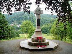
Once at Palerow Lane turn right to head eastwards along the road for a short distance until it ends at a T-junction, and then turn right along another road for a few yards, until a footpath leads off to the left before a farm at Sandy Ford is reached. This footpath heads northwestwards across fields, and is easy to follow as the Midshires Way is very well waymarked. The path crosses a road (strangely called Jackass Lane) by Netherpark Farm, and then dives downhill to the north, entering an area of woodland along the access track to Shining Cliff youth hostel. The path crosses Peatpits Brook and, shortly afterwards, curves slightly to the right at a complex path junction, heading uphill along another track. This track heads northeastwards into the small Park Plantation, and then curves to the left to head northwestwards, eventually joining a green lane that heads past a war memorial and reached Higg Lane. Join the road and follow it as it crosses Pendleton Brook and curves to the west of the school at Alderwasley Hall. When a track comes in from the right turn left to heads northwestwards along another footpath, slowly turning to head on a more northerly course as it crosses a succession of small fields.
The footpath descends downhill to reach Watergate Farm, and then cross Mere Brook and start following a footpath that leads uphill to the northwest. The footpath is easy to follow as it climbs over a hill, before descending to meet another road. Cross the road, and once on the other side start walking along Intake Lane, a rutted lane that heads northwestwards, passing a campsite on the right. After about a mile the track turns sharply to the right and then to the left, before resuming a northwesterly course as it descends slowly downhill. The track is quite dark as it descends under the heavy tree cover, and fairly soon a dark and foreboding bridge under the High Peak Trail is reached, and it is here that we say goodbye to the Midshires Way, which turns off to the left to join the trail above. This route continues on under the bridge, and descends for about a kilometre, joining a minor road and passing houses before ending at the A6(T). Cross the A6(T) to reach the pavement on the other side, and then turn to the left to head northwestwards along it for a short distance until a complex traffic-light controlled crossroads is reached.
At the crossroads turn right along a road that virtually doubles back on itself as it descends towards Arkwright's Mill, and it then curves to the left to head northeastwards past Cromford Wharf to the bridge over the River Derwent. Cross the bridge, and on the other side follow the road as it curves to the right (at this bend the route up to Willersley Castle, to which I walked, heads off, but I will not describe that short walk as it is peripheral to the main route). After this bend turn left along a road that heads steeply uphill, curving to the right sharply before slowly curving to the left as it climbs uphill, taking a northerly course towards the little village of Starkholmes. The route from here is very simple; follow the road as it heads through Starkholmes, and then as it descends towards Old Matlock. The road curves to the right passing the church, before curving to the left to reach the A615 road in Matlock Green. Turn to the left and follow the A615 as it heads northwestwards into Matlock; it passes a linear set of play areas and formal gardens squeezed in between the river and the road, before reaching Crown Square in the centre of Matlock. Once at the roundabout in the square turn left to cross the River Derwent, and once the road curves to the left on the other side turn right to enter the station car park. Matlock Railway Station is a short distance away along the access road that leads through the car park, and is well signposted.
Distances
| From | To | Distance (m) | Ascent (ft) | Descent (ft) |
|---|---|---|---|---|
| Derby station | Duffield | 6.0 | 358 | 305 |
| Duffield | Cromford | 11.9 | 1988 | 1890 |
| Cromford | Matlock station | 2.3 | 364 | 341 |
This makes a total distance of 20.2 miles, with 2710 feet of ascent and 2536 feet of descent.
For more information on profiles, ascents and descents, see this page
Transport
There are regular train services from Matlock back to Derby; these are usually hourly. There are also some bus services as well that run from the nearby bus station in Matlock, although the bus station in Derby is a distance away from the railway stations, and the busses generally take longer.
Disclaimer
Please note that I take no responsibility for anything that may happen when following these directions. If you intend to follow this route, then please use the relevant maps and check the route out before you go out. As always when walking, use common sense and you should be fine.
If you find any information on any of these routes that is inaccurate, or you wish to add anything, then please email me.
All images on this site are © of the author. Any reproduction, retransmissions, or republication of all or part of any document found on this site is expressly prohibited, unless the author has explicitly granted its prior written consent to so reproduce, retransmit, or republish the material. All other rights reserved.
Although this site includes links providing convenient direct access to other Internet sites, I do not endorse, approve, certify or make warranties or representations as to the accuracy of the information on these sites.
And finally, enjoy your walking!
Nearby walks
| # | Title | Walk length (miles) |
|---|---|---|
| 11 | Stanton Moor | 2.9 |
| 12 | Darley Dale, Stanton Moor and Rowsley | 8.7 |
| 14 | Friden, Long Dale and Gratton Dale | 7.8 |
|
|

|