Walk #639: A circular walk from Buxton to Wheston and Taddington
 |
 |
|
General Data
| Date Walked | 27/12/2004 |
| County | Derbyshire |
| Start Location | Buxton marketplace |
| End Location | Buxton marketplace |
| Start time | 08.19 |
| End time | 15.30 |
| Distance | 18.8 miles |
| Description | This was a lovely walk, taking in some areas of the Peak District that I have never walked before, along with some old favourites. |
| Pack | Today I carried my 30-litre Karrimor HotRock rucksack, which was filled with three litres of water, a spare fleece, waterproofs and various electronic gadgets. |
| Condition | I am fairly tired after this walk, which is probably to be expected after such a long walk. Towards the end of the day the side of my right knee was aching, which was more of an annoyance than anything else. |
| Weather | The day started off fairly clear with scarcely a cloud in the sky, but this eventually changed with some dark grey clouds coming overhead. There were some short periods of light drizzle that were not enough to force me to put my coat on. The wind was bitterly cold when I was exposed to it, and it was generally a cold day. |
| OS map | Outdoor Leisure number 24 (The Peak District - White Peak Area) or Landranger number 119 (Buxton & Matlock, Bakewell & Dove Dale) |
 |
 |
|
 |
 |
|
Map of the walk
Maps courtesy of Google Maps. Route for indicative purposes only, and may have been plotted after the walk. Please let me have comments on what you think of this new format. For a detailed table of timings for this walk, please see the table file.
 |
Notes
This was a walk that I had planned some months ago, and as I was up in Derbyshire for Christmas I thought that it was a good opportunity to do it. It was still dark when I set off from my parents' house for the long drive north into the Peak District along roads that were slippy after the heavy overnight frost. It was starting to get light by the time that I reached the centre of the town, and parked in a car park by the market place. The parking bay cost three pounds and as I did not have enough coins to pay I went into a shop opposite to buy a bottle of water and some chocolate and get some change. It did not take me long to get all my kit together and shoulder my rucksack, so I locked the car and started heading off down the road.
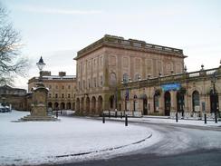
Buxton is a town that has never really impressed me, and although it has some lovely buildings it also has some fairly unattractive areas. Initially I could feast my eyes on some superb architecture that seemed to be enhanced by a covering of snow, and I soon passed a solicitor's office where an old friend works. However I soon ended up leaving the attractive areas and started descending past the station, the highlight of which is the old fantail window set in a wall, the only remains of the old station building. I soon found myself passing under the tall, majestic viaduct that carries the Buxton to Hillhead Quarry freight line over the town, and started climbing uphill along another road. This passed under a lower bridge that carries the Wye Dale line into the town; a line that may one day carry passenger trains once again.
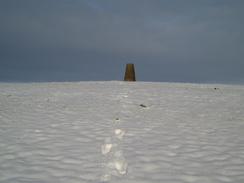
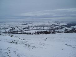
The pavements became increasingly slippy as I headed out of the town along the A6(T), and it was with some relief that I eventually reached the road that took me off the A6. The road took me eastwards for a short distance before I joined a footpath that started to head uphill. Although people had walked along the path before me and the snow was not virgin I still enjoyed finding untrodden patches of snow and letting my boots sink in with a satisfying crunching sound. The path was easy to follow and I soon found myself leaving it to start the short climb uphill to the first trig pillar of the day. I paused here and took in the magnificent views all around me, with the hills covered in snow and red skies from the sun that was still hanging low in the sky.
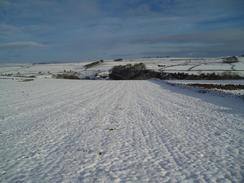
I managed to pull myself away from the pillar and headed back to the path, which soon became a rough track as it headed northeastwards towards the Tunstead limestone quarry. The going would have been quite boggy if it had not been for the ground, which was well frozen and therefore firm underfoot. I had planned to follow a footpath that lead across the quarry, but when I reached the western edge of the quarry I discovered a footpath diversion notice running for a year until April 2005. I considered attempting to cross anyway as the alternative route involved far more road walking, but in the end I started heading along another track for a few hundred yards until it ended at a road. This took me eastwards down an icy road, which was fortunately quiet so I could walk down the tracks made by cars, where there was considerably less ice and I could get better traction.
The road descended down to a bridge over a railway line by the northern edge of the Tunstead works, once the largest quarry in Britain. Tarmac has a large office beside the road, and I enjoyed looking at the snow covered railway sidings, and I noticed the areas not covered by snow where the point heaters had been working. What would have been a fairly boring and even ugly industrial scene was unexpectedly enhanced and even made pretty by the lying snow. The road continued on up a steep hill that soon had me puffing for breath and concentrating on finding a firm footing on the icy surface. My next target was the trig pillar on the top of Bole Hill, a short distance uphill from the road. I made my way past some startled sheep to the pillar, where once again I got some lovely views. I studied these for a while before heading back down to the road by a different route, taking in more deep virgin snow. At one point the gradient became steep and I found myself joyfully trudging through knee-deep snow, an experience I used to hate but now enjoy immensely.
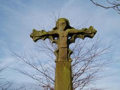
Back on the road I made good time towards the small village of Hargatewall, which I did not quite reach before taking a bridleway that headed northeastwards across fields before skirting the northern end of Peter Dale, which looked lovely in its covering of snow. At Dale Head I crossed the route of the Limestone Way, which I walked as part of my Land's End to John O'Groats walk, and started heading up a steep road that was very slippy with ice. I soon reached the little village of Wheston, where I visited a pretty carved cross that stands in an enclosure beside the road. This is quite exquisite and is not the sort of thing I expected to find in this area, and I studied it for a few minutes before heading back to the road and continuing on.
The trig pillar that stands on the top of the hill to the northeast of Wheston was my next target, and I headed along a snow-covered Water Lane before going through a gate and climbing uphill to the pillar. This was easy to find, although the views were not as good as they had been from the two previous pillars today, and I soon found myself running downhill through the snow back to the lane, and then back to Wheston. From Wheston I followed a bridleway, now part of the long-distance Pennine Bridleway route southwards. In a field beside the track a tractor was spreading muck over the snow, and the nauseating smell of this followed me for a while until the track ended at a toad. It was hard to tell the difference between the track and the road due to the snow covering, and I made good time south until the road ended at a junction. From here I joined the Limestone Way and followed it as it headed southwards along a track, scarcely avoiding being mowed down by a couple of Land Rovers who were out green laning.
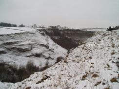
The track became increasingly steep as it stated descending down into the Wye Valley at Miller's Dale, and I got some nice views of the viaducts before joining the B6049 in the valley floor. I stopped to look at an old waterwheel beside the picturesque river before crossing a long wooden footbridge. On the other side a steep, stony path led up to the old Matlock to Buxton railway line, and I then joined another footpath that led through the old Miller's Dale lime works. This path started climbing gently before becoming increasingly steep as it skirted the eastern edge of the quarry face. The path was very slippy, and I was glad that I was ascending rather than descending as I could attack the slope more easily. The views from the path were superb, however, and more than made up for the tricky walk.
The gradient eventually slackened near the top of the quarry, and the path headed past old mine shafts towards the hamlet of Preistcliffe. Here I joined a long and winding road that led me south towards the A6(T), which I crossed carefully before entering the village of Taddington. I had hoped to get a good photo of the church, but I could not find a good viewpoint and because time was pressing I was loathed to search for too long. Instead I joined a footpath that headed westwards out of the village, climbing uphill towards a little water reservoir and some transmission masts. Near here was the final trig pillar of the day at Sough Top, from where there were some expansive views. At the pillar the wind was bitterly cold and blowing straight through me, so I took some photographs and hurried off westwards along the path, hoping to lose height and get out of the wind.
The path led westwards into the little village of Chelmorton, which has a nice church that I took a few photographs of before chatting about the icy conditions to a couple of ladies who were standing outside the village pub. Soon after the church I left the village by a track that led northwestwards, following the Midshires Way. About ten minutes along the track I got a phone call from a friend in Cambridge, and as we chatted I went off course, leaving the track and heading off along a different footpath towards Burrs Farm. I soon realised my mistake and headed off across a couple of fields back to the Midshires Way that runs along Caxterway Lane. The path eventually left the lane and headed across a couple of fields.
This soon led me onto the last obstacle of the day, the dip down into the steep-sided valley of Deep Dale. The path zigzagged steeply into the valley, and the path was treacherously icy. In a couple of places I chose to do down on my bottom as it was so slippy, and I was quite relieved when I finally reached the bottom of the valley. The path up the other side was less treacherous and I made good time until I got to the steepest section at the very top of the ascent. Here I chose to take what seemed to be a slightly easier route and this led me to a barbed wire fence at the top. This proved to be quite difficult to climb over, and I cursed as I ripped my trousers in two places.
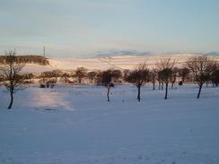
It was easy to get back to the proper path, and I followed it northwestwards to a road near King Sterndale church, and then across more fields to a farm at Cowdale. It was easy to follow as it headed on to Staden, and it then continued on towards a large and imposingly impressive railway viaduct. I took a few photographs of this before following the path under it and out onto a road that led onto the A515 to the south of Buxton. The rest of the walk was quite straightforward as I followed the A515 northwards into the town centre, and I soon arrived at my car in a tired but quite ecstatic state, after what had been a hard but very rewarding stroll.
Directions
This walk starts off at the market place car park in the centre of Buxton. Leave the car park and turn right, to head downhill in a rough northerly direction. When a roundabout is reached turn right, and start heading eastwards, passing the railway station before descending down to another roundabout. Head straight across this roundabout to another one, and then under a high railway viaduct to another. At this roundabout turn left, and follow the road as it curves around to the left, climbing up hill and under another, lower, railway bridge. As it climbs the road curves to the right and then the left, and when the gradient starts to slacken turn right down Waterswallows Road, which leads slightly north of east along the southern edge of Fairfield Common. When the road starts to curve to the left after about half a mile, turn right down a road for a few yards and then turn left to follow a footpath that climbs uphill to the east.
The path is clear and easy to follow as it passes to the south of a trig pillar, and soon afterwards the path becomes a track as it heads towards Daisymere Farm. The track becomes Green Lane as it climbs up a slight hill, crossing a road at Greenfairfield Farm and continuing on for another few hundred yards to the western edge of the Tunstead limestone works. There is a footpath across the quarry, but this was closed when I did this walk, so instead turn left to head northwestwards along a track for a little under half a mile until it reaches a road at Handybarn.
Once at the road turn right, and start following it as it heads downhill to the east, curving around to a bridge over a railway line by a large entrance to the quarry. Cross the bridge, and once on the other side follow the road as it climbs steeply uphill to the northeast. When the gradient slackens and the road curves to the right another road comes in from the left; follow the original road as it heads southeastwards around the southern side of Bole Hill, where there is another trig pillar. The road eventually settles on a more easterly course. Take the second road to the left, which curves past an area of woodland towards the little village of Hargatewall.
When Hayward Farm is reached on the left turn left down its access road, which heads through the farmyard and becomes a track on the other side. A footpath turns along this track, and it is easy to follow as it heads northeastwards for a mile before skirting the western edge of Peter Dale and descending down to meet the road at Dale Head. At the road turn right and follow it down for a few yards, cross the limestone Way footpath and then head steeply uphill on the other side. The road passes Bottom Farm and an exquisite cross in an enclosure on the tight before entering the little hamlet of Wheston. If you wish to visit the trig pillar then take a road that leads off to the left, heading uphill slightly, and when the road curves to the left take a green track called Water Lane that heads off to the right. Go a hundred yards along this track and then go through the second gate on the right, and head uphill to the trig pillar at the top of the hill. Once you have visited it return back to the road junction in Wheston.
Almost immediately after the road to the left a track leads off to the right, soon curving to the left to head in a more or less southerly direction for about half a kilometre, and when it meets a road continue straight on along this road. When the road ends at a T-junction after about half a mile continue straight on along a track, following the Limestone Way as it heads south. The path starts descending, and joins a track towards Monksdale Farm before descending steeply down towards the B6049 road into Miller's Dale. Once at the B6049 turn right and follow it west for a few yards until just before an old waterwheel is reached on the left; turn left before this and take a footpath that leads down to a footbridge over the River Wye. Cross the bridge, and once on the other side climb up a steep and stony footpath until it reaches the trackbed of the old Matlock to Buxton railway line.
Cross the trackbed and on the other side take a footpath that enters the site of the old Miller's Dale Quarry. The footpath heads south for a short distance before curving to the left to start climbing steeply up to the southeast, following the eastern edge of the quarry. The footpath is steep and fairly rough, so care should be taken on the climb. Once the top of the quarry is reached the gradient slackens, and it is easy to follow as it heads on a slight west of southerly course for about a kilometre, before meeting a track near Lydgate Farm. Follow the track for a few yards past a house, and then take a minor road that leads off to the left. This road heads southwestwards for a short distance, squeezing between a house and a bank, before curving around past Rock Lodge Farm to head southeastwards and reach the A6(T).
Carefully cross the A6(T), and on the other side continue on for a few yards until a road junction is reached. Turn left and walk southeastwards for a few yards to another junction just before the church. At this junction turn right and follow the road uphill for a couple of yards; when it curves to the left turn right to join a footpath that heads uphill to the west. It soon reaches a road; cross this and continue on along the footpath on the other side, which is easy to follow as it makes its way to a water reservoir at Sough Top. Continue westwards along the footpath as it passes a trig pillar, and then crosses Sough Lane and Pillwell Lane before descending steeply to meet the end of a track near the church in Chelmorton.
Turn left and follow the lane as it descends downhill for a short distance, passing the church and the village pub before reaching a road junction. Here turn right, and join the Midshires Way, which we will be following until the end of the day. Initially this leaves Chelmorton on a footpath that heads northwestwards, but after it crosses the A5270 Old Coalpit Lane it follows a green lane called Caxterway Lane. After about half a mile the track curves to the right; shortly before this the footpath leaves to the left, crossing a series of small fields northwestwards before coming to the eastern bank of Deep Dale.
The path zigzags down the steep side of the dale, and once at the bottom climbs up the other side in a similar fashion to reach the fields on the western side of the valley. Continue on along the footpath, keeping a field boundary to the right until it ends at a road by King Sterndale Church. Turn left along the road for a few yards, and when it curves to the left turn right along another footpath. This skirts the south side if Kid Tor before taking a more westerly course to reach the farm at Cowdale. Stay on the Midshires Way as it leaves Cowdale, heading in a rough westerly direction for about a kilometre until it reaches Staden.
The path is easy to follow as it heads west from Staden, and starts dropping down to pass under the first arch of an imposing railway viaduct. After this it joins a track that drops down before ending at a road in the valley floor. Turn left and follow this road westwards for a hundred yards until it reaches a T-junction with the A515 road. Once at the A515 road turn right, and start following it as it climbs uphill to the northwest. At the top of the hill continue straight across a complex road junction controlled by traffic lights, and continue on uphill until the car park at the market place is reached, where this walk ends.
Distances
| From | To | Distance (m) | Ascent (ft) | Descent (ft) |
|---|---|---|---|---|
| Buxton marketplace | Wheston | 7.3 | 978 | 902 |
| Wheston | Taddington | 5.1 | 794 | 785 |
| Taddington | Buxton marketplace | 6.4 | 850 | 935 |
This makes a total distance of 18.8 miles, with 2622 feet of ascent and 2622 feet of descent.
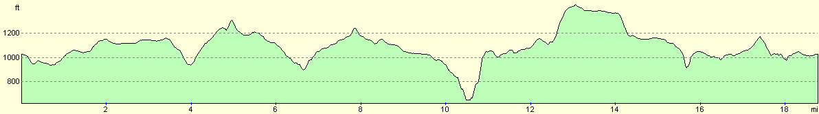
For more information on profiles, ascents and descents, see this page
Disclaimer
Please note that I take no responsibility for anything that may happen when following these directions. If you intend to follow this route, then please use the relevant maps and check the route out before you go out. As always when walking, use common sense and you should be fine.
If you find any information on any of these routes that is inaccurate, or you wish to add anything, then please email me.
All images on this site are © of the author. Any reproduction, retransmissions, or republication of all or part of any document found on this site is expressly prohibited, unless the author has explicitly granted its prior written consent to so reproduce, retransmit, or republish the material. All other rights reserved.
Although this site includes links providing convenient direct access to other Internet sites, I do not endorse, approve, certify or make warranties or representations as to the accuracy of the information on these sites.
And finally, enjoy your walking!
Nearby walks
| # | Title | Walk length (miles) |
|---|---|---|
| 1 | Shining Tor and Cat's Tor from the Cat and Fiddle pub | 7.2 |
| 13 | Edale and Kinder Scout | 11.0 |
| 14 | Friden, Long Dale and Gratton Dale | 7.8 |
|
|

|