Walk #652: Ledbury to Hereford
 |
 |
|
General Data
| Date Walked | 27/02/2005 |
| County | Herefordshire |
| Start Location | Ledbury station |
| End Location | Hereford station |
| Start time | 09.21 |
| End time | 15.26 |
| Distance | 17.1 miles |
| Description | This was a surprisingly enjoyable walk after yesterday's epic stroll, taking in footpaths and short sections of road walking to head westwards from Malvern to Hereford. |
| Pack | Today I carried my 30-litre Karrimor rucksack, filled with my usual set of detritus and kit. |
| Condition | I awoke this morning with a snivelling cold, and as the day went on this slowly got worse. Aside form this I feel fine, and could have walked further after a little rest. |
| Weather | The day was quite mixed, with sunshine and cloud and one light flurry of snow. It was a reasonably chilly day for the time of year, although I only felt cold when I was exposed to the full force of the wind. |
| OS map | Landranger number 149 (Hereford & Leominster, Bromyard & Ledbury) |
 |
 |
|
 |
 |
|
Map of the walk
Maps courtesy of Google Maps. Route for indicative purposes only, and may have been plotted after the walk. Please let me have comments on what you think of this new format. For a detailed table of timings for this walk, please see the table file.
 |
 |
|
 |
 |
|
Notes
As I awoke this morning in the nice B&B that I had booked myself into last night, I could see blue skies outside the window with only a scattering of clouds. Some snow had fallen overnight, and the tops of the Malvern Hills were once again covered in a frosty covering of snow. Breakfast was very nice, and afterwards I chatted to the landlady for a while before loading up my car and heading down the road to Ledbury. I paused in the town to go onto a shop to buy a newspaper, and when the assistant enquired about what I was doing he did not seem to believe that I was planning to walk to Hereford. If anything this is a relatively short walk for me, and so I just smiled and left.
I was quite concerned about time for all of today's walk; I was aware that once I reached Hereford I would have to get the train back, and once I had done that I was faced with a three-hour drive back to Cambridge. For this reason once I reached the car park at Ledbury I did not prevaricate as I am sometimes known to do, and assembled my kit and headed off. The first part of the route followed the Ledbury Town Trail, which follows the high embankment of an old railway line to the west of the town. I left this after ten minutes to take a footpath westwards; on my rather old (circa 1989) map this goes across fields, but housing and industrial development had sprung up and followed me until I reached a main road that now acts as the western boundary of Ledbury.
Once across the main road an easy to follow footpath took me westwards across field before I entered a hop orchard and eventually a minor road, Another footpath took me further west, and it was here that I encountered the first problem of the day; I had to cross a stile at a muddy field boundary, and as I placed my hand on the stile pole to pull myself up an unseen piece of barbed wire dug itself deeply into the fourth finger on my right had. I pulled it away and a spurt of blood came out, so I sucked on it as I climbed over the stile before eventually wrapping a spare hanky around the wound. Frankly the positioning of the barbed wire on the pole was terrible, and I could imagine other people doing the same thing.
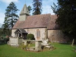
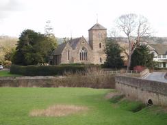
I soon reached the A4172 road above Little Marcle, and started following roads and a couple of footpaths westwards towards Putley Church. This church looked superb in the morning sunlight, and the trees that surrounded the church made an enticing backdrop. The church itself is quite small, but the setting really was noticeable. A little distance away there was a large hall, Putley Court, that I studied as I puffed my way uphill, although I could not really get a good photograph through the trees lining the road.
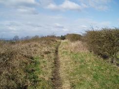
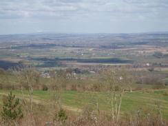
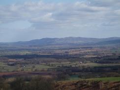
By the time that I reached the charmingly-named Woolhope Cockshoot I had had enough of road walking, and so I decided to take a path that headed off to the tight, climbing up to the ridgeline of Seager Hill through some woodland. There is a track but no right of way marked on the map, and so I was unsure about whether the track was walkable, but a sign on the gate at the bottom of the track warned about fire risk and the ground was churned up, which I took as a good sign that the public were allowed along the track. Initially the path was slightly muddy and overgrown as it headed uphill through the trees, but once I reached the top I was greeted by a stupendous view of the white-topped Malvern Hills to the east. The sight took my breath away (although that could have been the result of the climb) and I stopped to take in the great views along the plains.
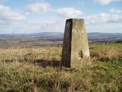
The track along the top of the ridge was easy to follow until I got near to the trig pillar, where a couple of gates blocked the way. This was the first indication that the track as not a right of way, and unfortunately the gates had vertical boards that made them very hard to climb. Eventually I found a way around them that would not damage anything, and I walked the short distance to the trig pillar. This is situated in a field and whilst the views were not quite as good as they had been at the southeastern edge of the hill they were good nonetheless, as hopefully the photographs that I took will testify. The track continued on from the pillar with the trees ever-present on the left, before eventually becoming a better track and descending down to a complex junction of tracks in Cockshoot.
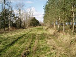
These tracks were obviously forestry tracks, and I chose one that fortunately took me in the correct direction through the woodlands. This was a pleasant enough walk, and I even managed to see a deer come running across the track about fifty yards on front of me, a sight that I always find enchanting. Eventually this track ended at a road near a house, which it was guarded from by another gate. This proved easier to get over, and I was soon striding uphill past a large quarry to reach the top of Tower Hill, from where a dirty and overgrown road led me south towards Backbury Hill. I had wanted to climb this to find a trig pillar, and the footpath was easy to follow past the site of the pillar on the Ordnance Survey map. Unfortunately I could not see any trace of it existing on the ground, although the area was scrubby woodland and it would have been easy for me to miss it.
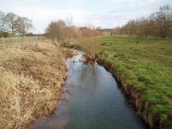
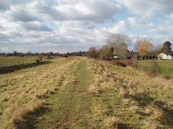
I did not want to spend too long searching as I was aware that I still had to catch a train, and so, disappointed, I headed down the hill along footpaths and a road to reach Old Sufton and, eventually, a larger road that heads along the eastern bank of the River Lugg. I followed this south into the small hamlet of Mordiford before following the B4224 road over the old bridge (I assume from the village's name that there used to be a ford here before the bridge, and Mordi' may be an altered from of Mudd'?). Time was becoming less pressing as I realised that I would be able to make the 15.45 train, and so I decided that instead of following the road I would take a footpath that headed northwestwards along the southern bank of the River Lugg. For most of the way this followed the top of a flood bank, and I watched as a couple tried to shepherd a newborn lamb towards its mother. The wind was really cold and the banking exposed so for the first time today I put my balaclava on to keep my face warm.
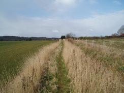
I had developed a cold overnight and as the day went on this had been getting worse, and by this time my nose was in full flood. Fortunately I always keep some hankies with me (which had proved useful for me cut finger earlier), but these did not prevent me from feeling quite grotty. I strode on through the village of Hampton Bishop, where I was amused by a thatched cottage that had a thatched cat sitting at one end of the roof - a feature that I cannot recall having seen before. I soon crossed the B4224 road and started following a footpath along the northern bank of the River Wye as it headed towards Hereford. This was a lovely stretch of path, and I tried to make the most of the views as I walked beside the flowing waters.
The riverside path ended too quickly, and I was faced by a last couple of miles towards the railway station in Hereford. My route took me through the suburbs of the town and not through the centre, so I did not get any views of the cathedral aside from a few glimpses of spires. This was a shame, but I did not have much time to spare before my train and so I could not afford to take a diversion through the town centre. Eventually I reached the railway station with about fifteen minutes to spare before the train left; this proved ideal and allowed me time to buy a ticket and use the toilet without rushing. I had not been expecting today's walk to be very good, but I was pleasantly surprised to find that it had been a very fulfilling walk, although not as classic as yesterday's walk over the Malvern Hills.
Directions
This walk starts off at Ledbury railway station. Leave the station car park by the approach road, and when this ends at the A439 road after a few yards turn right towards a bend in the road. At the bend join a footpath to the right, which climbs uphill before joining the Ledbury Town Trail. This is an old, disused railway line that heads over the A438 on a bridge before heading south through the town. When a narrow bridge over a road is reached after half a mile leave the path and turn right, to join a cycle path that heads past a school and goes westwards through a housing estate. The cycle path soon ends, and a footpath continues on past industrial buildings and across some scrubby fields before reaching a main road.
Cross this road and once on the other side follow a footpath that heads westwards, crossing a stream before heading across fields and entering a hop orchard. The path heads to the left of some buildings before continuing on for a short distance to end at a road. Turn right along this road for a couple of hundred yards before taking a footpath that leads off to the left; note that this is the second and not the first footpath. The footpath heads in a rough westerly direction, descending to cross a stream before climbing up to meet a road. Turn left along this road and then after a few yards turn right to follow another footpath southwestwards towards the A4172 road. I could not find the proper exit onto the A4172 road so I walked further south until I found a way onto the road near to a road junction immediately to the north of Little Marcle.
Take the road junction as it heads northwestwards for a hundred yards before turning sharply to the left to head in a more westerly direction. After about a kilometre take a footpath that leads off to the tight, heading past a hop orchard and heading northwestwards before reaching a road junction. Head straight across at the junction and follow a road northwestwards into Putley Green. Take the first road off to the left, which heads westwards before turning to the right along a footpath that ends at a road beside Putley Church. Continue straight on westwards along this road as it climbs uphill; when it ends at a junction turn left along another road that heads southwards for a hundred yards before turning right along another road.
This road climbs steeply uphill, before flattening out as it heads westwards and eventually climbing steeply once more before ending at a road junction in Woolhope Cockshoot. Turn left and the immediately to the right, to head northwestwards along a road for about fifty yards until a gate is reached on the right. Go through this gate, and follow a path that heads uphill northwards through the trees before emerging from them at the top of the ridge on Seager Hill. Turn left and follow the path northwestwards along the ridgeline, keeping the trees on the left. After a couple of miles the path starts to descend down through the trees and becomes of better quality before ending at a complex intersection. Take a path that heads uphill in a rough westerly direction; this climbs uphill through the woodland before flattening off and descending down to end at a gate beside a public road. Go through the gate, and once on the other side start heading uphill along a road with a large quarry to the right.
The road soon ends at the top of Tower Hill beside a house, here turn left and start walking down a track southwards towards Wooton. The road then curves to head southwestwards; just before a house is reached on the right turn right along a track that leads uphill. After a hundred yards turn right along a footpath that leaves the track to the right; this climbs up over Backbury Hill before joining a track and ending at a road. Turn right and follow this road westwards for a hundred yards; just before a car park is reached on the left turn left down a bridleway that heads southwestwards towards Old Sufton, where it joins a track that heads westwards towards a road.
Once at the road turn left and start following it southwards until it ends at the B4224 road in Mordiford. Turn right and follow the B4224 road as it crosses the River Lugg on a bridge, and once on the western side of the river turn right to join a footpath that climbs onto the top of the flood bank. The footpath follows the southern side of the river as it curves to take a westerly course; when a track is reached on the eastern side of the village of Hampton Bishop turn left down this track for a hundred yards until it ends at a road. Turn right along this road and follow it as it heads westwards through the village. At the western end of the village the road curves sharply to the left; follow it as it heads southwards past some house before taking a footpath that leads off to the right to head westwards towards the B4224 road.
Turn right along the B4224 road for about fifty yards before taking a footpath that heads off to the left. Initially this follows a flood bank westwards, but it soon diverts off to the left across a field to join the northern bank of the River Wye. Follow the path as it heads along the river upstream, until it eventually diverts away to the right to go through a small housing estate and reach the B4224 road once more. Turn left to walk along the B4224 until Old Eign Hill road leads off to the right; follow this road as it heads uphill before curving to the left to head west. When a junction is reached turn right and follow Hafod Road as it heads northwestwards before reaching a soundabout with the A438 Ledbury Road. Cross the roundabout, and on the other side follow Bodenham Road as it heads northwestwards before ending at the A465 Aylestone Hill. Turn left and follow the A465 as it heads downhill for a short distance; once it crosses the railway line on a bridge turn right and follow a road as it passes a DIY store and reaches Hereford railway station, where this walk ends.
Distances
| From | To | Distance (m) | Ascent (ft) | Descent (ft) |
|---|---|---|---|---|
| Ledbury station | Woolhope Cockshoot | 6.1 | 778 | 400 |
| Woolhope Cockshoot | Hampton Bishop | 7.1 | 981 | 1460 |
| Hampton Bishop | Hereford station | 3.9 | 112 | 75 |
This makes a total distance of 17.1 miles, with 1871 feet of ascent and 1935 feet of descent.
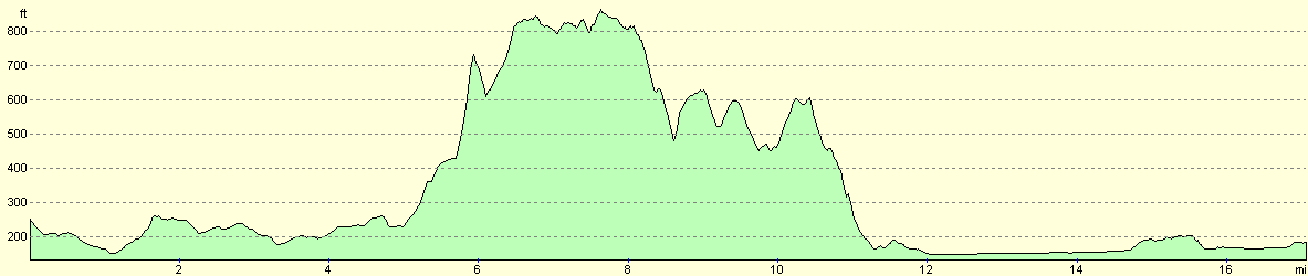
For more information on profiles, ascents and descents, see this page
Transport
There are regular train services between the railway stations in Hereford and Ledbury; these are less frequent on Sundays, but the journey is still feasible. Please see the National Rail Enquiries website for more details.
Disclaimer
Please note that I take no responsibility for anything that may happen when following these directions. If you intend to follow this route, then please use the relevant maps and check the route out before you go out. As always when walking, use common sense and you should be fine.
If you find any information on any of these routes that is inaccurate, or you wish to add anything, then please email me.
All images on this site are © of the author. Any reproduction, retransmissions, or republication of all or part of any document found on this site is expressly prohibited, unless the author has explicitly granted its prior written consent to so reproduce, retransmit, or republish the material. All other rights reserved.
Although this site includes links providing convenient direct access to other Internet sites, I do not endorse, approve, certify or make warranties or representations as to the accuracy of the information on these sites.
And finally, enjoy your walking!
Nearby walks
| # | Title | Walk length (miles) |
|---|---|---|
| 651 | Malvern to Ledbury | 16.4 |
|
|

|