Walk #676: Farnham to Gomshall
 |
 |
|
General Data
| Date Walked | 11/06/2005 |
| County | Surrey |
| Start Location | Farnham Station |
| End Location | Gomshall Station |
| Start time | 10.15 |
| End time | 17.39 |
| Distance | 20.7 miles |
| Description | This was a surprisingly enjoyable stroll, much of it through woodland as I followed the North Downs Way eastwards. |
| Pack | Today I carried my 30-litre Karrimor rucksack that was filled with various accoutrements. |
| Condition | My feet suffered a fair bit today, and towards the end they were fairly sore. I also had a little trouble with chaffing, although this only became obvious once I had finished walking. All in all it could have been worse considering it is three weeks since I last did a walk. |
| Weather | The day started off bright and sunny with scarcely a breeze, although as the day went on it slowly started to cloud over. Although it remained dry whilst I was walking, when I was on the train on the way back to Farnham it started to rain quite heavily. |
| OS map | Landranger number 186 (Aldershot & Guildford, Camberley & Haslemere) and Landranger number 187 (Dorking, Reigate & Crawley area) |
 |
 |
|
 |
 |
|
Map of the walk
Maps courtesy of Google Maps. Route for indicative purposes only, and may have been plotted after the walk. Please let me have comments on what you think of this new format. For a detailed table of timings for this walk, please see the table file.
 |
 |
|
Notes
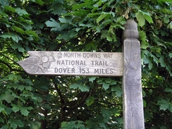
At the beginning of this year I set myself the target of walking the North Downs Way, a National Trail that runs from Farnham to Dover, skirting close to the south of London. The walk follows the course of the M25 for a long distance and for this reason I was not in much of a hurry to start it, and whenever I allocated a weekend to go down and start walking, I would find something better to do. Three weeks ago I finished the TGO Challenge, and since then I have not done any walks, and so I was aware that my body would be starting to get out of shape. I therefore found myself leaving Great Shelford at 07.45 morning, for the two-hour drive south to Farnham and the start of the trail. I had a fairly eventful journey; I headed off on a wild-goose chase along the A414 in totally the wrong direction, a mistake that added fifteen minutes onto the journey and a few points on my blood pressure.
Eventually I found myself at Farnham railway station, and my first problem was to find a ticket machine at which to buy the �3.10 parking ticket for the day. Annoyingly the two that I could find were out of order, so I was forced to walk across the car park to the station, where I bought one at the ticket office. Quite what I was to have done if the ticket office was closed I do not know! All of this made me even later, and it was ten fifteen before I was finally ready to head off down the road to wards a junction with a main road, a couple of hundred yards away from the station. Here was a sign proclaiming the start of the North Downs Way, and it has to be the worst starting place of any of the National Trails that I have done so far, as it is situated right beside a dual carriageway.
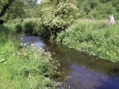
Fortunately the going soon became better, and although the noise of the dual carriageway still intruded on the walk I found that I was following a very pleasant stretch of path, along what was seemingly a long disused road beside a narrow, trickling stream, which turned out to be the River Wey. I turned the volume on my Walkman up to mask the noise of the traffic, and I was relieved when the path finally turned to head eastwards away from the dual carriageway. There was a nice engraved bench beside the path at the corner of a field commemorating the North Downs Way; I can only assume that this is the first relatively quiet place that they could find to put it!
The path rejoined a quiet road and used this to cross the River Wey, which again was little more than a stream. A short climb took me uphill, and the path then skirted the edge of a field with a real stink hanging in the air - I think that the field to the left was being used as a tip, and it really reeked. A short distance on a jogger came past and I chatted to him for an enjoyable couple of minutes, before strolling on. The path passed the golf course on Furze Hill, and just before I left the road the jogger passed again, and he walked alongside me for a few minutes as we chatted. He turned out to be an ex-marathon runner who still jogged for pleasure, and I found myself feeling quite jealous, as I cannot jog or run very far at all.
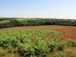
The next couple of miles took me eastwards towards Totford Hatch across the edge of a hill, with the views north towards the Hog's Back blocked n most places by trees. Some of the fields had a lovely, almost red, carpet of flowers on them, making for a lovely sight that uplifted me as I strolled along. Unfortunately although I could not see the Hogs Back I could easily hear the traffic on the A31 that runs along the top of the linear hill, and this accompanied me all the way eastwards to Puttenham. the church in the village is slightly unusual, with dormer-style windows in the roof, which in turn slopes down to a low level, meaning that the roof is far bigger than the walls. I left Puttenham and immediately crossed the B3000, and there followed a very pleasant walk over Puttenham Heath along a good path.
The trail passes under the A3, and on the bridge overhead there are two wooden crosses; apparently a reminder of the fact that the Pilgrim's Way also follows the route. I did no pay the Watt's Gallery much attention, and I headed on eastwards along a fairly undistinguished stretch of path. Eventually a track led to a road, which in turn led down to the A3100 road immediately to the south of Guildford. By this time I was felt in need of a rest, and so when I saw the Ye Olde Ship Inn on the other side of the road I could not resist going in for a quick drink. Because of my late start I knew that I could not spend too long there, but I guestimated the distance left to walk and the time that it would take, and worked out that I could afford to spend about half an hour. In the end I was in the pub for nearly forty minutes, during which time I drunk two lovely pints of Abbott and had a couple of packs of crisps. Hopefully the badness of the latter will offset the goodness of the Satsuma's that I had been scoffing all morning.
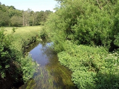
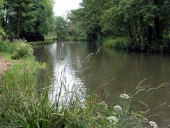
I was much more relaxed when I left the pub, and I headed down a lane towards the River Wey Navigation. On the way the track passed over a railway line and there were some people waiting; they told me that a special was due through, and as he was speaking a train could be seen heading through the tunnel to the north. Unfortunately this tuned out to be a normal multiple unit and not anything of much interest, so I headed down to the Navigation. this turned out to be an attractive stretch of water and of much more interest, and I took a few photographs before heading over a delicate footbridge to get to the other bank. A quick walk across Shalford Park took me to the A281, which proved easy to cross. I soon found myself following the path up to the top of Whinny Hill, heading through patches of some attractive woodland. A short descent down to Halfpenny Lane was followed by a nice ascent up a sandy track to the church at the top of Martha's Hill.
Again the views from here were slightly spoiled by the trees, but there were gaps through which I could get some superb views to the south. Apparently it is possible to see eight counties from the summit, but with the trees and the slightly hazy skies it was far from possible to do so today. The church has been a site of pilgrimage since 1463, although there is little evidence that this was as a result of the Pilgrim's Way, which is probably a relatively modern invention. The descent eastwards of the hill led me to a road, which took me northwards for a short distance before climbing uphill to head through the trees towards the car park beside the A25 at Newlands Corner. Although I was short of time I decided to stop off and buy a ludicrously large ice cream at the stall, which I ravenously wolfed down as I headed eastward through the trees.
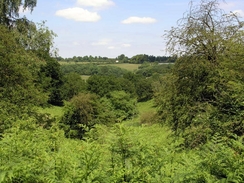
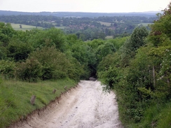
The next few miles flew by as the path headed through the trees, which loomed close-by overhead. In dark, damp weather the path would have been quite gloomy, but with sunshine overhead it made for a very enjoyable walk. I pushed myself on to walk faster as the path crossed Netley Heath, with a few concrete signs of the Canadian Army, which had had bases on the Heath during the Second World War. Before I knew it I found myself at Beggar's Lane, where I would be leaving the North Downs Way for the walk down to the nearest railway station. The junction with the North Downs Way was marked by a burnt-out van. After the last few miles of pleasant woodland walking this was an annoying sight, and as I headed down the rough track I felt myself feeling rather grumpy. This mood was not helped by the state of the track, which was deeply rutted chalk that made my aching feet ache even more as my toes banged against the front of my boots as I headed down the steep track. It was therefore a relief when the gradient slackened and it passed under the railway line, after which I had to join the A25 for the short walk westwards towards Gomshall railway station.
There were no ticket machines at Gomshall Station, and when the train arrived I got on ready to buy a ticket. However no guard arrived, and by the time the train pulled into Guildford station I had not paid. There was not long before my next train to Aldershot, and so I sprinted across the footbridge and reached the train a few minutes before it was due to go. I settled non my seat, and I was surprised to find that, again, not guard came to sell me a ticket, and so when the train reached Aldershot I walked to the ticket office and purchased a ticket for the last leg of the journey to Farnham. I was tempted to buy a ticket for the whole journey, but if they are not putting conductors on trains to sell tickets then I will be blowed if I will go and do their job for them. As it happens the next stage of the journey was on a bus as the line was closed for maintenance work, and by the time the bus pulled into Farnham station it was raining quite hard. I had not had a proper meal all day, and so I walked to a pub that was a few yards down the road from the station, and was amazed to find that they were not serving food after seven on a Saturday evening! Slightly annoyed at this I walked back to the car, changed into my trainers and started the drive back to Gomshall. I took a couple of wrong turns in Guildford, but eventually I found myself passing through Gomshall, and I pulled up outside the Compasses Inn to get some food. I had some lovely sausages, served in a large Yorkshire Pudding along with some bubble and squeak, all of which was covered in a delicious, thick gravy. This made me feel much better, and I arrived at the youth hostel in fine spirits.
Directions
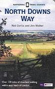
The walk is also covered in detail in the North Downs Way National Trail Guide, by Neil Curtis and Jim Walker, ISBN 1 85410 853 0, published by Aurum Press Ltd.
The exception to this is the last mile, where I left the North Downs Way for the stroll down to Gomshall Railway station. This was a very easy stretch to walk; when the track of Beggar's Lane is reached near TW09674875 turn right to head southwestwards down the deeply rutted track. Once the gradient slackens follow the track as it heads under the railway line before ending at the A254. Turn right and follow the A25 westwards for a few hundred yards; just before the railway bridge over the road is reached turn right up a narrow footpath that leads up to Gomshall Railway station.
Distances
| From | To | Distance (m) | Ascent (ft) | Descent (ft) |
|---|---|---|---|---|
| Farnham Station | Puttenham | 7.2 | 682 | 607 |
| Puttenham | Guildford | 4.2 | 305 | 459 |
| Guildford | Beggar's Lane | 8.2 | 1138 | 643 |
| Beggar's Lane | Gomshall Station | 1.1 | 39 | 397 |
This makes a total distance of 20.7 miles, with 2164 feet of ascent and 2106 feet of descent.
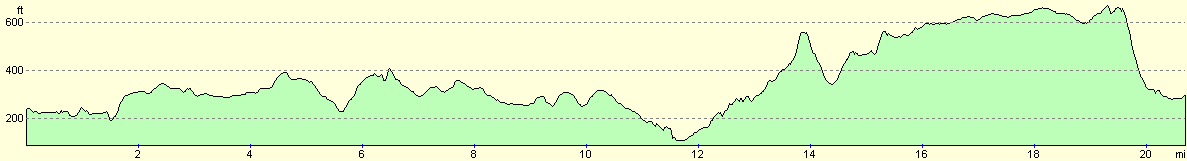
For more information on profiles, ascents and descents, see this page
Transport
There are regular trains between Gomshall and Farnham railway stations; unfortunately this journey involves one or two changes of train during the journey.
Accommodation
I spent the night at The Holmbury St Mary Youth Hostel, Radnor Lane, Dorking, Surrey RH5 6NW, Telephone (01306) 730777. This youth hostel is situated about three miles to the south of Gomshall and therefore a little too far away from the North Downs Way; however as I had my car it proved to be a very useful place to stay. A night's accommodation cost me eleven pounds in what is a particularly nice youth hostel.
Disclaimer
Please note that I take no responsibility for anything that may happen when following these directions. If you intend to follow this route, then please use the relevant maps and check the route out before you go out. As always when walking, use common sense and you should be fine.
If you find any information on any of these routes that is inaccurate, or you wish to add anything, then please email me.
All images on this site are © of the author. Any reproduction, retransmissions, or republication of all or part of any document found on this site is expressly prohibited, unless the author has explicitly granted its prior written consent to so reproduce, retransmit, or republish the material. All other rights reserved.
Although this site includes links providing convenient direct access to other Internet sites, I do not endorse, approve, certify or make warranties or representations as to the accuracy of the information on these sites.
And finally, enjoy your walking!
This walk was mentioned in the following routes:
| The North Downs Way |
Nearby walks
| # | Title | Walk length (miles) |
|---|---|---|
| 599 | A circular walk from Westhumble to Surrey's highest point | 20.0 |
|
|

|