Walk #820: A circular walk from Shrewton
 |
 |
|
General Data
| Date Walked | 15/08/2008 |
| County | Wiltshire |
| Start Location | Shrewton |
| End Location | Shrewton |
| Start time | 09.11 |
| End time | 17.32 |
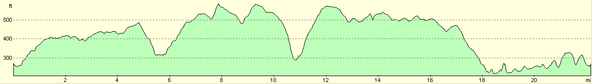
| Distance | 22.2 miles |
| Description | This was a lovely walk, following tracks across and to the south of Salisbury Plain. |
| Pack | Today I carried my 30-litre Karrimor rucksack, filled with waterproofs, a book and other odds and ends. |
| Condition | I injured my right ankle a few weeks ago, and this gave me pain for pretty much all of the walk. Aside from this, I was relatively fine, with no other problems to report. |
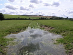
| Weather | The day was bright and sunny, with occasional cloudy spells. It was quite warm, although not overly so for the time of year. |
| OS map | Landranger number 184 (Salisbury & The Plain, Amesbury) |
 |
 |
|
 |
 |
|
Map of the walk
Maps courtesy of Google Maps. Route for indicative purposes only, and may have been plotted after the walk. Please let me have comments on what you think of this new format. For a detailed table of timings for this walk, please see the table file.
 |
 |
|
 |
 |
|
Notes
It had been a couple of weeks since my last week, a lag caused by a combination of poor weather and an injury to my right ankle that was not healing. I was even uncertain if I would walk today, as I had some pain in the ankle last night as I walked upstairs. Eventually, with Sencan's encouragement, I decided to go. Next I had to decide which walk to do. The last one I completed was a local one without much scenery, and so this time I wanted something a little wilder. Since I moved down to the south coast I had been neglecting Salisbury Plain, so it seemed like a good place to do a walk.
The drive to Shrewton did not take as long as I expected - the traffic through Salisbury was not bad despite it being the morning rush hour, and after 45 minutes I arrived in the village. There was nowhere obvious to park, so I pulled up on a wide road a few yards uphill from the village shop. Before setting off I went down to the shop, which is a bit of a labyrinthine place, much larger than it looks from the outside and stocked with all sorts of niceties. I bought a bottle of water and two chocolate bars for the day, to go along with the sandwiches that Sencan made me before I set off.
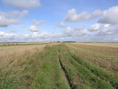
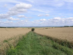
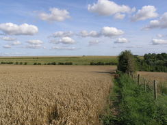
I had done the first part of this walk before in 2004, and I remembered enjoying certain aspects of it. I was there in good spirits as I headed off. The initial part of the walk took me up the A360 road - it was busy, and I made slow progress as I stepped onto the narrow verges to avoid the worst of the traffic. It was there a relief when the track was reached that would take me westwards. A piggery lay between the road and the track, and the smell was quite severe; fortunately it was soon passed, and the track took me on westwards, the sun beating down on me when it appeared through gaps in the cloud. Ominously my right ankle started giving twinges as I walked over the uneven ground, and soon the discomfort started to increase.
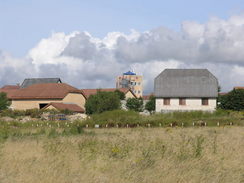
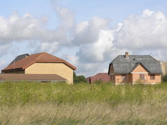
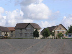
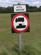
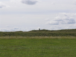
The signs of military life soon started appearing - warning signs and notices covered in foreboding messages. I took heed of these and continued on, crossing a couple of concrete tracks before glimpsing a strange roofline beyond the trees in the distance. These were the buildings of a mock German village called Copehill Down, which is used by soldiers to practice urban fighting. It is a slightly incongruous but, to me, lovely sight. The rooflines of the buildings all look foreign, and if were to you put glass in the windows instead of the wooden shutters then they could have been livable in.
My route took me to the south of the village, and as I strolled along the sound of a tannoy system boomed out, asking people to switch off their mobile phones. Last night on TV there had been a news article about an MOD-sponsored grand challenge into autonomous anti-insurgent vehicles taking place on Salisbury Plain - this was obviously taking part in the village. Road and flying vehicles were being put through their paces. It was interesting to be there at the same time, although I could see nothing aside from two large cranes with cameras on, and a fuel truck that arrived, complete with an army Land Rover as an escort.
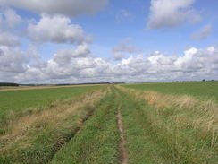
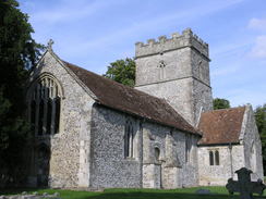
Tracks took me westwards, initially on the level before a descent started down towards the village of Chitterne. The tops of roofs soon became visible, but it seemed to be a while before the track unceremoniously ended at a road. I plodded along this into the centre of the village; the church was away to my right, and nearby there was a sign banning tanks from the village. The way some people drive 4x4's through my village, I wondered if it would be handy to have one of these outside my house. The pub was shut, and even if it was open I had not walked far enough to be rewarded with a stop.
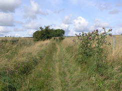
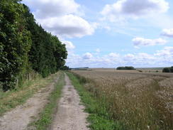
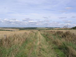
A climb along a sunken lane was a pleasant change, as it was nice and cool with the trees that hung overhead. This took me up onto Breakheart Hill, the gradient slackening as the sides of the track opened out, along with the views. My ankle hurt on the ascent, although once back on the level it was much improved. the walk westwards along the next stretch was pleasant enough; the views were not too expansive as the path followed the top of the hill.
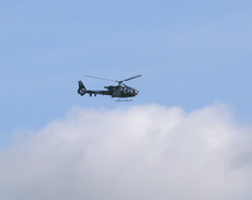
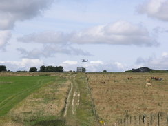
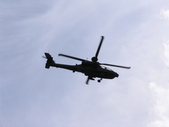
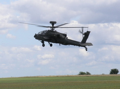
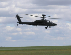
As I approached the point where I would turn off the Imber Range path I saw an Apache helicopter ahead of me. It would hover low above the ground, then rise and do a long circuit before returning a few minutes later. I found the sight entrancing, the machine looking so ominously dangerous. Near Knock Barrow I stopped to try and get some good photographs of it, before heading south down another track.
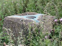
A series of tracks took me south uphill, and then eastwards, before descending down towards the Chitterne Brook. I was in need of a break by this time, but I pressed on, crossing a road and climbing up Clay Pit Hill. Eventually I reached a little trig pillar, and it was here that I decided to stop for lunch. The trig pillar was on the other side of the fence and I decided not to climb over to get the flush bracket number - the pillar was overgrown, and my ankle felt too dodgy for any climbing or the walk to the nearest gate. Instead I sat down on the verge of the track and are the delicious sandwiches that Sencan had prepared for me. Salad and ham were squeezed between slices of bread, and the whole thing exploded as soon as I removed them from the wrapping. It was extremely tasty, and fortified me for what was still a long walk ahead of me.
Due to the pain from my ankle I was tempted to cut the walks short and take a more direct route back to Shrewton. In the end stubbornness won, and instead I took my planned route. This took me southeastwards, and after passing a combine harvester busy collecting grain, I saw another Apache in the distance. This seemed to be hovering, and soon signs told me that this was a military airfield. The helicopter would hover for a while, do a circuit and then come around once more towards me. I managed to get a couple of good shots off at it, and I noticed with amusement that the gun at the front moved to follow me as it flew around - the gun follows the movement of the pilot's head, so as he looked at me it moved.
Eventually the large grassy area of the airfield was left behind, and the track became rougher as it approached the impressive banked ramparts of Yarnbury Castle. Again there was a trig pillar visible on the banks, but I was not in a mood to divert off to visit it. Instead I walked on, soon reaching the A303 dual carriageway. I had expected this to be difficult to cross, but it was remarkably easy due to a wide central reservation that allowed me to treat it as having two halves.
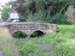
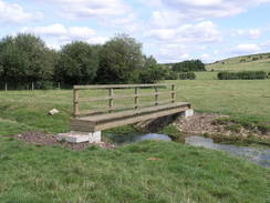
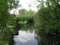
On the other side of the road there was a pig farm, and the smell from this accompanied me as I strolled southeastwards. Soon a track crossing was reached, and here I started a long descent towards the village of Berwick St James. This was to be the last of the high-level tracks that I would follow today, the rest of the day being on lowland paths and tracks. The pub in Berwick St James was passed, and it was tempting to nip in for a quick rest. Instead I strolled on, crossing a bridge over the River Till before passing a farm that had a large circular boot brush outside it. After this a pleasant walk northwards along a footpath followed, although the river was always out of view to the left.
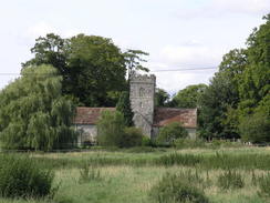
Eventually the church at Winterborne Stoke became visible, rising up out of the grass. It was a surprisingly pretty view, and although I was flagging the view helped me progress onwards. Soon I reached the A303(T) in the village, and I had to wait for a few minutes for a gap in the traffic to form. On the opposite side of the road was a pub, and it as tempting to nip into this for a quick drink. Time was pressing, however, and I felt that if I stopped I would not be able to restart. So instead I pressed on, following a track that led towards a barn.
Shortly after this there was an old enclosure ditch on the right, in which were several tumuli. I was too tired to go and have a look at this, and instead continued along the path as it fell and then rose up to meet a road. From here it was a simple road walk back to Shrewton, but it proved to be quite hard and far from enjoyable, although this was totally down to my fatigue. Some men were drinking some pints outside a pub in the village, and I was quite envious of them as I headed back towards the shop in the village. This was handy as it allowed me to buy a bottle of Ribena - I had run out of water, and was in need of some refreshment.
My car was only a short distance away, and as I hobbled towards it I looked back on what had proved to be a frustrating walk. It should have been lovely - the scenery in particular was good, and the encounters with the Apache helicopters fascinating - but the discomfort from my right ankle was distinctly worrisome. I will have to ensure that this is looked at before I try another walk.
 |
 |
|
 |
 |
|
Directions
This walk starts off in the car park of the Royal British Legion in Shrewton, which is near to the church. Leave the car park and turn left, to start heading northwestwards out of the village along the A360 road. Pass the junction with the B390 on the left, and continue on up the hill. Just after a left-hand bend turn left along a green lane (actually a by-way) at The Gibbet. When the by-way turns off to the right fairly soon continue straight on along a green lane. Initially this heads westwards, before taking a slightly more northerly route. The path is easy to follow on the ground even though it is unfenced, and it crosses a couple of concrete tank tracks before eventually reaching the Imber Range Perimeter Path at another concrete track, just before the buildings of the Copehill Down mock German village is reached. From here the Path heads off to the left and is signposted; I found it easier to join the track and follow that around the south side of the village (however, if you do this be very aware of military vehicles).
The path became more distinct on the southwestern side of the village, where a T-junction in the tracks is reached. Here follow the path as it heads westwards across the plain for a couple of miles, before eventually descending downhill to meet a road junction to the east of Chitterne. Head westwards down this road for a short distance to another T-junction, and then turn left to head south for a few yards to a T-junction with the B390 road. At the B390 turn right to walk westwards past the village pub, and at a sharp left-hand bend turn right up another track that heads steeply uphill to the northwest onto the top of Breakheart Hill.
From here the track is distinct and easy to follow; be careful not to divert to the north into the military firing range. Continue along until a track junction is reached immediately to the west of Quebec Barn, and then turn left to head southwards, with a hedge on the right. As the track curves to the left continue straight on, passing Quebec Farm before ending at a road.
Carefully cross this road and then head southwestwards along another track that heads uphill; soon a linear band of trees is followed on the left. At the top of the hill is another patch of trees; pass these and then turn left, to start heading eastwards, with the belt of trees to the left. Continue on along this track; it crosses another track before meeting a second. Here turn left and then right, to continue eastwards across a field. The path slowly starts descending downhill, eventually crossing Chitterne Brook on a footbridge before rising slightly to meet a road.
Cross the road and then continue on eastwards along another bridleway, which climbs up onto Clay Pit Hill. Keep on this track as the ascent slackens and finally levels off, passing a trig pillar to the south of Chitterne. Just before the B390 road is reached, turn right down another track. This heads uphill to the southeast, continuing on for a couple of miles before skirting the eastern ramparts of Yarnbury Castle and reaching the A303(T) dual carriageway.
Take care crossing this road, and then continue on southeastwards along a track on the other side. A little over a mile later a track crossing is reached to the east of The Penning; here turn left to start heading eastwards down a track that leads into the village of Berwick St James. At the main road turn left and follow it northwards through the village for a short distance; after the pub turn right to head eastwards down a track. This crosses the River Till, before curving to the left to enter a farmyard.
Continue on through the farmyard, and then follow a track onwards with trees on the left until a cottage is reached. Pass the cottage, and then join a footpath that heads northwards to the east of the river, crossing fields. Soon Winterbourne Stoke church becomes visible; head towards this, and join a road that heads north to reach the A303 in Winterbourne Stoke.
Again, take care in crossing the main road, and on the other side follow a track that passes a farm before heading roughly northwards. At a right-hand bend the track curves down to cross the River Till once more, before curving to the left to reach Foredown Barn. Just before the farm turn left along a bridleway that runs northwards with a hedge on the left, passing an old enclosure in Fore Down.
The bridleway sticks to the eastern side of the embryonic river as it climbs once more, curving to head northwestwards before reaching the A344 road. Join the road and follow it as it heads northwestwards, falling and climbing before eventually descending down into Shrewton. Follow the road as it curves around to the right, and continue on until the car park of the Royal British Legion is reached on the left, where this walk ends.
Distances
| From | To | Distance (m) | Ascent (ft) | Descent (ft) |
|---|---|---|---|---|
| Shrewton | Knook Barrow | 7.9 | 643 | 328 |
| Knook Barrow | Near B390 | 5.0 | 400 | 492 |
| Near B390 | Berwick St James | 5.4 | 220 | 489 |
| Berwick St James | Shrewton | 3.9 | 361 | 315 |
This makes a total distance of 22.2 miles, with 1624 feet of ascent and 1624 feet of descent.
For more information on profiles, ascents and descents, see this page
 |
 |
|
 |
 |
|
 |
 |
|
 |
 |
|
 |
 |
|
 |
 |
|
 |
Disclaimer
Please note that I take no responsibility for anything that may happen when following these directions. If you intend to follow this route, then please use the relevant maps and check the route out before you go out. As always when walking, use common sense and you should be fine.
If you find any information on any of these routes that is inaccurate, or you wish to add anything, then please email me.
All images on this site are © of the author. Any reproduction, retransmissions, or republication of all or part of any document found on this site is expressly prohibited, unless the author has explicitly granted its prior written consent to so reproduce, retransmit, or republish the material. All other rights reserved.
Although this site includes links providing convenient direct access to other Internet sites, I do not endorse, approve, certify or make warranties or representations as to the accuracy of the information on these sites.
And finally, enjoy your walking!
Nearby walks
| # | Title | Walk length (miles) |
|---|---|---|
| 629 | Shrewton to Warminster | 16.7 |
| 790 | A circular walk from Salisbury | 24.0 |
| 849 | A circular walk from Urchfont to Etchilhampton and West Lavington | 16.4 |
|
|

|