Walk #845: A circular walk from East Meon to Butser and Old Winchester Hills
 |
 |
|
General Data
| Date Walked | 11/03/2010 |
| County | Hampshire |
| Start Location | East Meon |
| End Location | East Meon |
| Start time | 09.27 |
| End time | 15.13 |
| Distance | 14.6 miles |
| Description | This was a pleasant walk from East Meon to Butser and Old Winchester Hills. |
| Pack | Today I carried my 30-litre Karrimor rucksack, filled with waterproofs, a book and other odds and ends. |
| Condition | My feet suffered again today - although, surprisingly, I had no new blisters at the end of the day, the remnants of the ones I suffered on MOnday caused me a great deal of discomfort. |
| Weather | Today was mostly grey and cloudy, with a chilly breeze. The sun made a lasting appearance at the very end of the day. |
| OS map | Landranger number 185 (Winchester & Basingstoke, Andover & Romsey) and Landranger number 197 (Chichester & The South Downs, Bognor Regis & Arundel){ |
 |
 |
|
 |
 |
|
Map of the walk
Maps courtesy of Google Maps. Route for indicative purposes only, and may have been plotted after the walk. Please let me have comments on what you think of this new format. For a detailed table of timings for this walk, please see the table file.
 |
 |
|
 |
 |
|
Notes
I have only done three walks this year, and I have suffered from some fairly severe problems with blisters on my feet. When you consider that I walked 6,200 miles in a year and only got four significant blisters, you can see how my walking condition has deteriorated during the last year. For this reason, I decided that instead of attempting around twenty miles - a distance I could manage with few problems - I would do something around twelve or thirteen. My feet were blistered after Monday's walk, and this was another reason to take it easy. My last few walks have been fairly flat, so I also wanted to do one with a little more ascent. After studying my maps, I decided to do a circular walk based around the South Downs Way and East Meon.
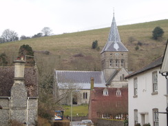
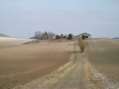
Although East Meon is not too far away from my home near Romsey, it is not the easiest place to get to, and the last few miles were along narrow roads. I knew little about East Meon, except for the fact that the pretty church was pictured on the front cover of the Ordnance Survey map. As I approached the village I saw a sign pointing to a car park; I turned around and parked in a fairly large car park beside some allotments. My first impressions of the village were positive, especially the new housing visible to the north.
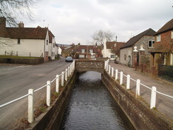
I got my kit together and headed through the village. I had not packed any water for the day, a little bit of a risk given the remoteness of the walk (there were going to be no pubs on the walk). Fortunately I came across a small village shop, and I nipped in to buy a bottle of water and a few snacks for the day. I then headed off. The centre of the village is exceptionally pretty; a stream runs by the High Street, and although the houses lining it are not, say, Cotswold pretty, they are hardly unattractive. The only problem is that the promised sun had not made an appearance, and instead a grey curtain of cloud hung overhead.
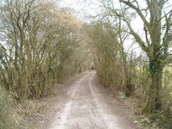
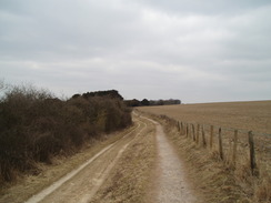
A country lane led me eastwards, and this then became a green lane that was a mixture of surfaces, from hard chalk to rutted earth to concrete. It was a pleasant stretch, and I listened to an audiobook as I strolled along. A road was joined, from where I could see an aerial at the top of the massive Butser Hill. The stretch of road did not last long, and a green lane started to take me southwards.
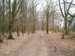
I had intended to follow this track as it slowly climbed the hill, and then divert off to the trig pillar at the top of the hill. Instead, I found a stile leading off to the left into an area of woodland. This appeared to be well-walked, and it was not obvious where it could go except up the hill. The path was steep, but soon emerged from the tree cover and headed up onto Ramsdean Down. Petersfield became visible on the left, along with many other nice views.
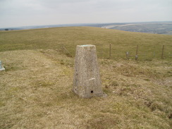
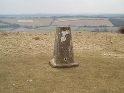
The climb was steep, and showed me exactly how much fitness I have lost during my sabbatical from walking. Although I did not need to stop, it was a relief when the gradient started slackening and I could stride off. The top of the hill is fairly flat, and covered in a series of objects aside from the obvious massive aerial. I angled off to visit the trig pillar; as I was taking a photo, a glider came nearly directly overhead - a beautiful, graceful sight.
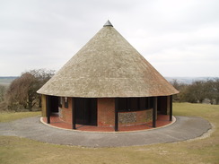
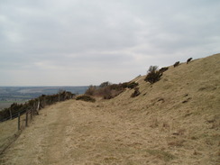
I made my way from the pillar past the mast, and then down to the many car parks on the hillside (there are some toilets in a circular building) to join the South Downs Way. After this a road led me southwestwards, still quite high, with little descent. A thin silvery line off to the left marked the sea; in sunshine the views would be spectacular. As it was the clouds made the view hazy, but were still good. The stiff breeze was quite chilling.
The path took me westwards, soon heading into an area of woodland that must be spectacular later in spring and summer. A road was rejoined that took me up to Mercury Park, an old MOD base that is now abandoned. Seeing all the empty houses was quite saddening. A little further on was the Wetherdown sustainability centre. I stayed in the hostel here when I walked the South Downs Way a few years ago, so when I saw a sign for a cafe I decided to nip in. It was fairly busy with kids and their parents, but I had a nice cup of tea and a slice of flapjack. On the wall there is a sign showing how many kilowatt-hours they are generating from their solar panels. All very new-age, but nothing wrong with that.
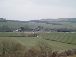
I set off again, and decided to divert off my main route to follow the South Downs Way to the trig pillar on Wether Down. This is on top of a reservoir next to a little farm compound, and the views from the top were superb. When back on my proper route, I followed a road westwards across Chidden Down; again, there were some good views. Indeed, they were so good that I decided to abandon my planned route, which followed the Monarch's Way downhill, and instead stayed to the high ground. My feet were starting to ache again, and I could feel a couple of blisters starting to form on my little toes; there was little that I could do to fix this, so I hobbled on.
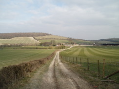
Soon the road reached the South Downs Way once more, and I headed along a track that headed towards Old Winchester Hill. This is an old hillfort that I have visited on several different walks; it is well preserved, and the ditches are still visible. I walked alongside the ditch instead of heading straight across the centre, then climbed the banking and headed over to the trig pillar and viewpoint. Again the views were slightly spoilt, and I did not hang around too long because of the breeze. Instead I headed back the way I had come to the road, following the South Downs Way.
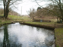
A good off-road path means that you do not have to follow the road (although not a single car passed me on the way), and then a path heads steeply downhill to Whitewool Farm. There are a series of fishing ponds by the farm, and a sign indicated a cafe in a wooden cabin by the track I was following. I headed in, and chatted to the ladies inside as one cooked me a superb bacon sandwich. This only delayed me for ten minutes or so, and I then headed back along the South Downs Way, leaving it as it met a green lane.
A path took me eastwards to meet a road near East Meon; I followed this back towards the village. My feet were hurting less now, but I decided that it might be best to stop the walk here, so I headed back through the village to my car park. It had been a good day's walk, but the views would have been superb on a clear, sunny day.
 |
 |
|
 |
 |
|
Directions
This walk starts off from the car park by the allotments in East Meon. Leave the car park and follow Workhouse Lane as it heads eastwards through the village. At a road junction continue straight on along High Street, passing a shop on the left. Continue with a stream on the left; the stream veers away to the left, and follow the road onwards. Take the first road, Greenway, off to the left, and follow this as it curves around to the right past some houses.
At a sharp right-hand bend at SU687220, turn left and start following a track that heads eastwards for a mile. It initially climbs uphill on a good-quality surface, before becoming rutted as it progresses. At a junction of five paths and tracks (creating a large expanse a little like a green roundabout), continue straight on along a track. This heads slightly south of eastwards, becoming a concrete track before ending at a road at SU703219. Turn right down this road for a few yards, before turning to the left down another road. After a couple of hundred yards turn right to join a track at SU705216.
Initially this track slopes gently downhill, before starting to climb steeply uphill. A patch of woodland starts on the left; cross a stile and join a footpath that heads steeply uphill through the trees in a southeasterly direction, bursting out onto Ramsdean Down. Continue along the path as it climbs up the crest of the Down and the views unfold. Slowly the gradient slackens; at the top pass through a gate and head slightly to the left to reach the trig pillar at the top of Butser Hill.
From the trig pillar, head towards the aerial mast; pass to the left of it and join a track that leads downhill to some car parks. Pass through the car parks and then join the access road, where the South Downs Way is joined. The road becomes Limekiln Lane. At a road junction continue on along the top of the top of the hill southwestwards; at a complex road junction at SU705191 take the first road off to the right. This heads westwards, passing a house on the left before it becomes a track. Continue westwards along this track for 1.5 miles; at SU683188 It becomes a road and curves sharply to the right to climb up to Mercury Park.
At SU675191 Leave the South Downs Way and continue on westwards along a road that runs across Chidden and Teglease Down for a couple of miles. It starts to curve to the right to take a more northerly course. At SU647208 Rejoin the South Downs Way and follow a track southwestwards to the fort on Old Winchester Hill. When a gate is reached go through it and walk across the centre of the hill fort to the trig pillar. Once there, turn around and head back to the road.
At the road turn left and follow it northwards. There is a traffic-free route to the left which avoids the road, although it was quiet enough as I walked along it. After 0.6 miles a road junction is reached; here turn right and follow the South Downs Way as it heads steeply downhill to the southeast. At the bottom of the hill it joins a track that heads eastwards towards Whitewool Farm. At the farm turn left and then right, to follow a track eastwards, crossing a stream near a pond to reach a road.
Turn right down this road for 0.3 miles, and shortly after a cottage on the left turn left up a concrete track. This heads northeastwards for 0.6 miles until it meets a T-junction with a green track called Halnaker Lane. Here leave the South Downs Way, and continue straight on eastwards along a footpath. At some sheds turn left and then left again to pass to the right of the barn, and join a track that heads downhill to end at Coombe Road. Turn left to follow the road northwards; it turns to the right to enter East Meon. Follow the road as it curves to the left towards the centre of East Meon, passing a school on the way. When a junction with Workhouse Lane is reached, turn left to walk back to the car park where this walk started.
Distances
| From | To | Distance (m) | Ascent (ft) | Descent (ft) |
|---|---|---|---|---|
| East Meon | Butser Hill | 3.4 | 643 | 105 |
| Butser Hill | Wether Down | 3.8 | 266 | 384 |
| Wether Down | Old Winchester Hill | 3.3 | 187 | 315 |
| Old Winchester Hill | East Meon | 4.1 | 272 | 564 |
This makes a total distance of 14.6 miles, with 1368 feet of ascent and 1368 feet of descent.
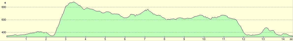
For more information on profiles, ascents and descents, see this page
Disclaimer
Please note that I take no responsibility for anything that may happen when following these directions. If you intend to follow this route, then please use the relevant maps and check the route out before you go out. As always when walking, use common sense and you should be fine.
If you find any information on any of these routes that is inaccurate, or you wish to add anything, then please email me.
All images on this site are © of the author. Any reproduction, retransmissions, or republication of all or part of any document found on this site is expressly prohibited, unless the author has explicitly granted its prior written consent to so reproduce, retransmit, or republish the material. All other rights reserved.
Although this site includes links providing convenient direct access to other Internet sites, I do not endorse, approve, certify or make warranties or representations as to the accuracy of the information on these sites.
And finally, enjoy your walking!
Nearby walks
| # | Title | Walk length (miles) |
|---|---|---|
| 709 | South Downs Way: Winchester to Wether Down | 20.4 |
| 710 | South Downs Way: Wether Down to Cocking | 18.2 |
| 797 | A walk from Wickham to Old Winchester Hill | 23.1 |
|
|

|