Walk #883: Blandford Forum to Pillwell
 |
 |
|
General Data
| Date Walked | 01/02/2011 |
| County | Dorset |
| Start Location | Blandford Forum |
| End Location | Pillwell |
| Start time | 07.51 |
| End time | 15.16 |
| Distance | 20.2 miles |
| Description | This was a pleasant stroll following the Stour Valley Way northwards through Dorset. |
| Pack | Today I carried my 30-litre Karrimor rucksack, filled with water, my waterproofs, a couple of books and other odds and ends. |
| Condition | I feel absolutely fine after this walk. |
| Weather | Today was not an ideal day for walking. There were several prolonged bouts of drizzle, made worst by a fairly fierce breeze. |
| OS map | Landranger number 194 (Dorchester & Weymouth, Cerne Abbas & Bere Regis) and Landranger number 183 (Yeovil & Frome, Shaftesbury & Shepton Mallet) |
 |
 |
|
Map of the walk
Maps courtesy of Google Maps. Route for indicative purposes only, and may have been plotted after the walk. Please let me have comments on what you think of this new format. For a detailed table of timings for this walk, please see the table file.
 |
 |
|
Notes
Late last year I had started off my walk along the Stour Valley Way. I had intended to complete it before the New Year, but events rather got in the way, and my walking in January had almost all been on the Isle of Wight. Since I would be moving out of the area in a few weeks, it seemed like a sensible idea to complete it as soon as possible. The previous walk had ended in Blandford Forum, an hour's drive away from home, so I set off in the dark.
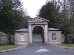
I had never actually been in Blandford Forum before, and I liked what I saw - it seemed like a typically lovely west country town, the sort of place that Thomas Hardy must have known and loved. Unfortunately I could not say the same: the first two car parks I found all had a maximum stay of just four hours, and there were no signs stating where a long-stay could be found. Event the public toilets required a few coins to enter. Eventually a friendly passer-by pointed me to a large car park behind the brewery.
All this kafuffle meant that I set off a good twenty minutes later than I should have done, and I delayed myself further by nipping into the large Tesco superstore to buy a few provisions. I started munching these as I joined the trail and started following it past the town. The roads were busy with people going to school, and I joined a disjointed line of straggling schoolchildren walking in the same direction.
It start to drizzle as I joined the road that headed up towards Byrnaston. The rain was not quite enough to cause me to put my coat on, but enough to get the outside of my fleece wet. I had walked this route before, and followed roads and paths more or less on autopilot towards Byrnaston School. I had gone off the trail here a few years previously, and the same thing happened again - the route around the school is terribly waymarked on the ground, and it was hard to find the proper route. I more or less found the correct route to the west of the school, before making my way down a wooded hillside to reach a track.
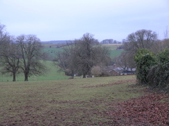
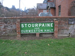
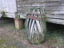
This led me towards the little village of Durweston; in the playing fields was an old station sign in Southern Railways green, a pleasant touch. The trail crossed the river by the mill, and a little further on the concrete supports of the station platform, long abandoned. The station was on the old and much-loved Somerset and Dorset railway line, parts of which are being reopened as the North Dorset Trailway, a stretch of which starts in Stourpaine. This stretch only opened in November, meaning that it was very new.
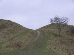
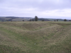
Unfortunately my route was going to be much less direct. After passing the church, the trail headed north out of the village and then up Hod Hill, which is dominated by the ramparts of the fort. This was a fascinating site; part of the ramparts are those of a 5th Century BC hill fort that was later invaded by the Romans (ballista bolts were found as a sign of the attack). The Romans made a smaller fort, the ramparts of which were also visible, although this was soon abandoned.
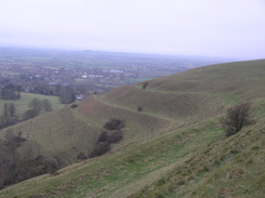
A steep but easy descent led down to a road, after which there was a very steep climb up onto the southern flank of Hambledon Hill. The grass and earth had been scraped off the steepest part of this ascent, making the walk on the chalk easy and not in the least slippery. It started to drizzle once the gradient slackened, and again I was left with the decision about whether or not to put my coat on. In the end I decided against despite the haze of rain in the distance.
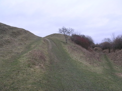
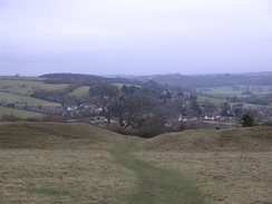
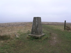
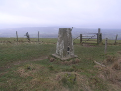
I strode past the trig pillar and on towards the ramparts of Hambledon hill fort, an unusual Neolithic fort that is shaped like a telephone receiver. The path became less clear once across the southern ramparts, but I just headed slightly west of north. In good weather the views would have been superb, but today they were spoilt somewhat by the persistent drizzle. There were some good views over the many levels of ramparts, however, even if the distant views were obscured.
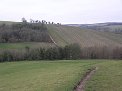
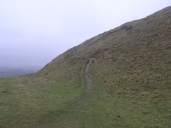
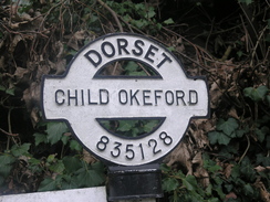
The path off the hill was exceptionally treacherous, the weathered chalk slippery on the steep path. It took me a while to get safely down without falling, a task that was more down to luck than good judgement. It was a relief to be down and able to walk to the pretty little village of Child Okeford. The trail left the village westwards to cross the river once more by a stretch of floodplain that had obviously suffered from the recent rainfall.
A fairly uninteresting walk took me north along the floodplain to the hamlet of Hammoon, before heading along a road southwards. The map shows the trail heading off westwards and then southwards towards the old railway line. However a sign on the ground showed that the track needed was private. A bridleway sign pointed down the field southwards, parallel to the road; I followed this for a short distance but at the bottom of the field realised I was heading in the wrong direction. I headed back around two other sides of the field to rejoin the track. It seems that I was not the only one inconvenienced by this.
Soon I came to the point where the footpath was due to head south across fields; a plank bridge over a ditch had been removed, and small trees planted in a gap in the hedge. I made my way around and through to the next field, navigating by dead reckoning. This led to a locked gate and footbridge over a stream. I negotiated these and made my way to rejoin the trail at the old railway trackbed. Research when I got home showed that, with the opening of this stretch of the trailway, the Stour Valley Way had been rerouted onto it. Unfortunately there were no signs to show this, and I lost a great deal of time walking around fields.
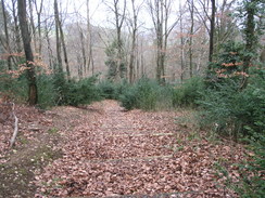
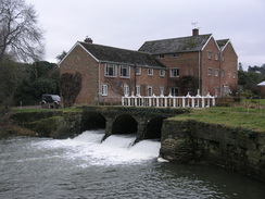
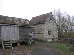
The trail did not spend long on the trailway before diverting off to pass Fiddleford Mill, now in the care of English Heritage. Another stroll along the floodplain took me to the town of Sturminster Newton.
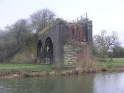
The cutting that carried the old Somerset and Dorset railway line through the town had been filled in since my map was drawn, the sight only being visible by a short panel of track on the filled-in ground. These alterations made it slightly difficult to find the route out of the town, but I eventually found the correct road. When this ended some steps led down onto the floodplain, near which were the arches of an approach viaduct to a bridge over the river. The bridge itself had long since been removed, but the arches still stood testament to the old line.
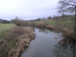
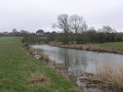
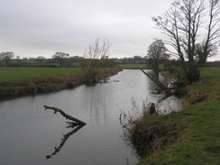
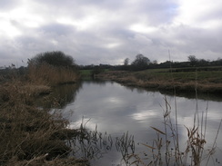
The next couple of miles were a highly pleasant amble along the bank of the river, and there was even the slightest glimpse of the sun on the water. I had given up on catching the next bus back from Pilwell to Blandford Forum, which meant that I had a long time to wait for the one after. This meant that I could amble along and enjoy the best of the day.
Unfortunately the last couple of miles to Marnhull were fairly nondescript as the trail crossed a series of small fields. Navigation was not particularly difficult, and there were waymarkers to point me in the right direction, but the numerous stiles and gates all took time to negotiate. To make matters worse, the walk alongside the river had spoilt me and these fields were nowhere near as scenic. It was a relief when I finally reached Marnhull. There was no sense in walking any further north, as there was a convenient car park where I could start the next day's walk to complete the trail. Instead I headed along the road through the village, which had plenty of attractive stone-built houses.
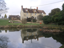
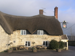
Eventually I reached a bus stop opposite the church. A quick glance at the bus timetable proved confusing; it showed two separate 309 services, one running on schooldays and the other not. Both of the times were different from the one that I had got off Traveline. Confused, I headed off to the Crown, the nearby pub. The apart nearest me had an attractive thatched roof, giving it an air of permanence. A sign inside the door stated that the pub was the Pure Drop Inn' in Hardy's Tess of the D'Urbevilles'. Fascinated by the literary connection, I entered.
The pub seemed to be empty aside from the barman, who greeted me like an old friend. Another customer entered as we chatted and I asked about the bus times. The customer told me a time, which unfortunately was different from the other three that I had. Then the barman came to the rescue; he phoned up the bus company for me and got me the proper time. It was a very friendly act that put my mind at ease. I left the pub about fifteen minutes before the bus was due, and I wandered down to the bus stop to wait for the bus. It arrived a couple of minutes early; surprisingly it was a double decker, nearly filled with schoolchildren. I climbed to the top deck and sat right at the front, wiping the windows so that I could watch the scenery roll past. It had been a slightly frustrating day's walk, and one that would have been improved by better weather.
 |
 |
|
Directions
This walk starts off at the long-stay car park on the southern side of the river in Blandford Forum at ST887059. Leave the car park via the access road and follow it as it curves to the right, passing a large Tesco store to reach a roundabout on Bournemouth Road. The rest of the day follows the Stour Valley Way.
Turn right and start following Bournemouth Road northwestwards for a third of a mile until it ends at a roundabout immediately to the south of Blandford Bridge over the river. Turn left for a hundred yards, and then take the first road off to the right, New Road. This head uphill; after two-thirds of a mile a junction with Forum View is reached on the right. Turn right along this road and follow it as it winds northwards for about a quarter of a mile.
When a phone box is reached at ST872066 in Byrnaston, turn left and then immediately right to join a footpath that heads downhill, aiming for the far left-hand corner of the field. Go through a gate and join a track that passes a club house on the right. The track soon rejoins Forum View, which can be followed northwards; when it curves to the right turn left along another road.
After a short distance the entrance driveway leading up to Byrnaston School is reached; just before this turn right along an access road to a farm, and then take a footpath that heads northwards uphill along the field. Cross a stile in the midpoint of the fence at the top of the field, then turn left between two fences to reach the school's access driveway. Unfortunately the route through the school is far from clear with poor signage; use the directions below as information only, and follow any better directions on the ground.
Turn right to head north along the track towards the school for a short distance, then turn left along a track. Follow this westward until it ends at a hedge, with a reservoir on the other side of the hedge. Turn right and follow this hedge northwards, crossing a fence without a stile. When a band of trees are reached, turn right to look for a stile off to the left beside a wooden farm gate. Cross this and start following a path, then steps down the slope. These end at an unsurfaced track amidst the trees; turn right and follow this as it winds around eastwards, more or less on the level, before ending at a junction with an access road to the school at ST867076.
Turn left and follow the single-lane track northwestwards; it becomes a public road as it enters Durweston. After 0.8 miles it ends at a T-junction with a road. Turn right along this road for a few yards, and then turn left down another road, passing a pretty thatched cottage on the right. This road curves to the right before ending at the A257 road beside the war memorial.
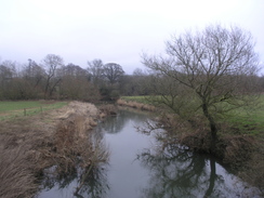
Carefully cross the A357, then turn left for a few yards until Mill Lane leads off to the right. Head down this track and follow it as it curves to the left to reach the river beside the mill. An obvious path turns to the right, crossing the river on a green pipe bridge. Continue on northeastwards along the track. Immediately after it passes under an old railway bridge, turn left along a footpath that runs between fences, crossing uneven ground as it angles towards Stourpaine church.
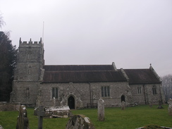
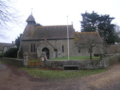
Go through a metal gate to reach the end of Manor Road beside the church. Head straight on along the road through the centre of the village for a quarter of a mile; follow it as it curves to the left. When the road ends, turn right along a good bridleway that heads northwards with a stream close-by. The bridleway soon curves to the left to start climbing uphill to the northwest between hedges up Hod Hill. It opens out as it crosses the ramparts of the old fort, and continues straight on as the gradient starts to level. Aim for the northwester corner of the fort; cross the ramparts and then take an obvious path chalk path downhill. This skirts some trees on the left, before curving to the right, joining a larger track before ending at a surfaced road at ST885112.
Cross the road and continue straight on uphill along a chalk track, initially with some woodland on the left. The ascent is steep; after a quarter of a mile a barn is reached on the left. Here the path swings to the left to continue climbing westwards up the hill. The track swings to the right to take a more northwesterly course; at a gateway turn right and join a minor footpath that continues on with woodland on the right. This leads to a footpath junction at ST849120; turn right through a gate and follow a good footpath that soon curves to the left to reach the trig pillar on Hambledon Hill.
Pass the trig pillar and continue on northwestwards along a good chalk path. It parallels, then crosses, the ramparts of an old fort. Once inside the fort, turn half-right to start heading northwestwards through the fort. The path is not obvious on the ground, but aim for the ramparts on the northwestern side of the fort at ST841129. From here head downhill to the west; the hill is steep and the chalk slippery, so care is needed.
At the bottom of the hill go through a clapper gate and a few steps before continuing westwards with a fence on the right. When the path nears a house beside a road, turn left along a footpath that parallels the road. Eventually this drops down a few steps to the right to meet Salisbury road in Child Okeford. Turn left and follow the road a short distance into the centre of the village. Pass the village cross on the left, and just before the village shop is reached, turn right down Haywards Lane.
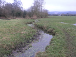
Continue as the lane curves to the left slightly; as it curves sharply to the left turn right to join a track. Do not follow the obvious track, and instead cross a stile beside a field gate to take a footpath that runs immediately to the north of it. When aline of trees on the right ends, cross a stile and turn half-right to head diagonally across a field to the far-right hand corner. Follow the obvious path across the next field; pass through a gate into the next field and then turn half-left to head towards a footbridge over the River Stour; a small stream needs to be crossed first. This field can be boggy, so you may need to take a winding route to reach the footbridge at ST824125.
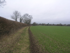
Cross the river and continue on along an obvious footpath across the next field, aiming for the far-right hand corner. Just before a gate is reached, turn right to cross a footbridge across a large ditch. The path then curves to head westwards for a short distance to end at a track opposite Bere Marsh Farm. Turn right and start following the track northwards for a quarter of a mile. When it curves to the left, continue straight on along a footpath that continues in a rough northerly direction.
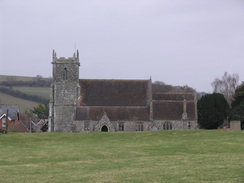
It skirts some woodland on the right and with a woodland burial ground on the left. It leaves the trees behind and crosses another field, skirting a broad hedge on the right. After this it keeps hedges on the left as it crosses a series of fields, eventually becoming a track that ends at a road in Nammoon at ST817143. Turn left down this road and head north for a couple of hundred yards until it ends at a junction opposite the small Hammoon church.
Do not approach the church, and instead turn left to follow a lane that soon curves to the left to take a southwesterly and then a southerly course. Here the route has changed from that shown on older OS maps; continue for three-quarters of a mile until an old railway trackbed is reached at ST813135, and then turn right to join the old railway line. Follow it as it heads westwards for 0.7 miles until a junction with a track is reached at ST802137. Turn left and follow this road as it heads southwards to reach a road in Fiddleford.
Turn right and follow this road westwards for a couple of hundred yards; when the road curves to the right continue straight on down a track towards Fiddleford Mill. At the mill turn right to squeeze between a stone barn on the right and a wooden one on the left, then left to join a footpath that crosses a sluice and then a footbridge to reach some fields. Head straight across the first field towards a hedge; cross a small footbridge over a stream and then continue on west-northwestwards across the floodplain. Aim for the far right-hand corner of the first field; skirt a hedge on the right and then head northwestwards across another field. This ends at a tract at ST790139.
Turn left and follow this track westwards between hedges. This ends at Penny Street; turn right and follow this road as it curves to the left to take a northwesterly course towards the centre of Sturminster Newton. The road curves to the left and then right to reach the B3092 in the centre of the town. Turn right to head northwards for a few yards, and then turn left down The Row. Head westwards along this road, and when it ends take a footpath that heads off down some steps northwestwards onto the floodplain.
Ignore the pretty footbridge leading over the river on the left, and instead turn right along a footpath that heads through scrubland to reach the eastern bank of the river beside the arches of an old railway viaduct. The path heads north-northeastwards through more scrubland and across a boardwalk, then starts to climb with the river off to the left. It remains high as the river curves to the left, then slowly descends to meet the river bank beside a footbridge over a stream. Stick close to the river bank for 1.3 miles as it curves to take a northerly course. Eventually it enters an area of woodland called Joyce's Coppice, eventually angling away from the river end ending at a road at ST776165.
turn right and start following this road uphill to the northeast. The gradient soon slackens; before the road curves to the right, turn left through a hedge and across a stile to enter a field. The path heads northwestwards with a hedge on the right; at the far corner of the field turn right into another field and keep a hedge on the left for just under a hundred yards. Keep another hedge on the right as the path heads northwards across a couple of fields. Pass an overgrown pond on the left, and continue on northwards, soon joining a hedge on the right. The path crosses a stile beside a gate to reach Mowes Lane at ST776177 beside Antell's Farm.
Turn left for a few yards down the lane and then right to head up a short track to a metal gate. Do not cross the gate, and instead turn right to cross into a field. Head north with a hedge on the left; go through the hedge and continue northwards. Pass the end of a hedge on the right and join another on the left that soon ends at another hedge. Cross through this into a field, with houses away to the left. Continue on with a hedge on the right; this reaches a pond. Keep the pond on the left and join a track that heads northwards, becoming a road before it ends at New Street at ST775184.
Turn left and then immediately right to head up Kenilsworth Road. When this ends turn right, keeping a driveway on the right, and cross a stile beside a gate to reach a field. Head north across a field, for path of the time with a hedge on the left. The hedge is left behind as the path cuts across the field. It meets a hedge; turn left and follow the path northwestwards until some barns are reached at ST773189. Pass the barns and then turn right to follow a track north-northeastwards; this eventually turns to the left and then the right before ending at Burton Street.
Here the Stour Valley Way is left behind. Turn right and follow Burton Street as it winds eastwards through Marnhull; after a third of a mile it curves to the right to head southwards for another third of a mile, ending at a junction with the church on the right. Turn left along the road for a few yards to reach the Crown Inn, where this walk ends.
 |
 |
|
Distances
| From | To | Distance (m) | Ascent (ft) | Descent (ft) |
|---|---|---|---|---|
| Blandford St Mary | Child Okeford | 8.9 | 1411 | 1289 |
| Child Okeford | Sturminster Newton | 5.9 | 197 | 213 |
| Sturminster Newton | Pilwell | 5.4 | 361 | 305 |
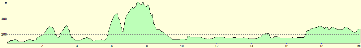
This makes a total distance of 20.2 miles, with 1969 feet of ascent and 1807 feet of descent.
For more information on profiles, ascents and descents, see this page
Transport
Damory service 309 runs infrequent services between the Pilwell (either outside the school or opposite the Crown pub) and the centre of Blandford Forum. It may be best to give them a phone rather than relying on the printed timetables.
 |
 |
|
 |
 |
|
 |
 |
|
 |
 |
|
 |
 |
|
 |
 |
|
 |
 |
|
 |
 |
|
 |
 |
|
 |
 |
|
 |
 |
|
 |
Disclaimer
Please note that I take no responsibility for anything that may happen when following these directions. If you intend to follow this route, then please use the relevant maps and check the route out before you go out. As always when walking, use common sense and you should be fine.
If you find any information on any of these routes that is inaccurate, or you wish to add anything, then please email me.
All images on this site are © of the author. Any reproduction, retransmissions, or republication of all or part of any document found on this site is expressly prohibited, unless the author has explicitly granted its prior written consent to so reproduce, retransmit, or republish the material. All other rights reserved.
Although this site includes links providing convenient direct access to other Internet sites, I do not endorse, approve, certify or make warranties or representations as to the accuracy of the information on these sites.
And finally, enjoy your walking!
Nearby walks
| # | Title | Walk length (miles) |
|---|---|---|
| 809 | A circular walk from Wimborne Minster | 25.0 |
| 810 | A circular walk from Shapwick to Stourpaine | 22.8 |
| 811 | A circular walk from Durweston to Woolland Hill and Milton Abbas | 22.9 |
|
|

|